
Gesamtpreis (1 Artikel Artikel):
Versandziel:

metselaar bart (8 Ergebnisse)
Direkt zu den wichtigsten Suchergebnissen
Suchfilter
Produktart
- Alle Product Types
- Bücher (8)
- Magazine & Zeitschriften (Keine weiteren Ergebnisse entsprechen dieser Verfeinerung)
- Comics (Keine weiteren Ergebnisse entsprechen dieser Verfeinerung)
- Noten (Keine weiteren Ergebnisse entsprechen dieser Verfeinerung)
- Kunst, Grafik & Poster (Keine weiteren Ergebnisse entsprechen dieser Verfeinerung)
- Fotografien (Keine weiteren Ergebnisse entsprechen dieser Verfeinerung)
- Karten (Keine weiteren Ergebnisse entsprechen dieser Verfeinerung)
- Manuskripte & Papierantiquitäten (Keine weiteren Ergebnisse entsprechen dieser Verfeinerung)
Zustand Mehr dazu
- Neu (8)
- Wie Neu, Sehr Gut oder Gut Bis Sehr Gut (Keine weiteren Ergebnisse entsprechen dieser Verfeinerung)
- Gut oder Befriedigend (Keine weiteren Ergebnisse entsprechen dieser Verfeinerung)
- Ausreichend oder Schlecht (Keine weiteren Ergebnisse entsprechen dieser Verfeinerung)
- Wie beschrieben (Keine weiteren Ergebnisse entsprechen dieser Verfeinerung)
Einband
- alle Einbände
- Hardcover (Keine weiteren Ergebnisse entsprechen dieser Verfeinerung)
- Softcover (4)
Weitere Eigenschaften
- Erstausgabe (Keine weiteren Ergebnisse entsprechen dieser Verfeinerung)
- Signiert (Keine weiteren Ergebnisse entsprechen dieser Verfeinerung)
- Schutzumschlag (Keine weiteren Ergebnisse entsprechen dieser Verfeinerung)
- Angebotsfoto (3)
Sprache (1)
Preis
- Beliebiger Preis
- Weniger als EUR 20
- EUR 20 bis EUR 45 (Keine weiteren Ergebnisse entsprechen dieser Verfeinerung)
- Mehr als EUR 45 (Keine weiteren Ergebnisse entsprechen dieser Verfeinerung)
Gratisversand
- Kostenloser Versand nach USA (Keine weiteren Ergebnisse entsprechen dieser Verfeinerung)
Land des Verkäufers
Verkäuferbewertung
-
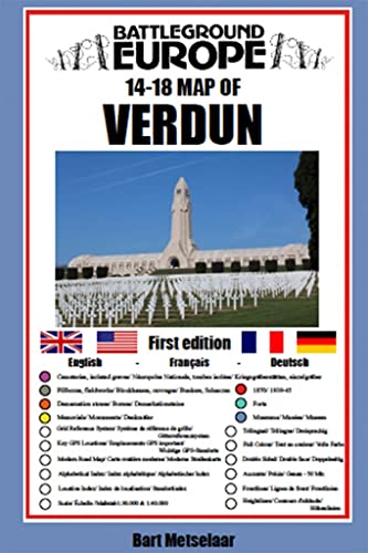
Verdun (Map)
Anbieter: PBShop.store UK, Fairford, GLOS, Vereinigtes Königreich
Verkäuferbewertung 4 von 5 Sternen

EUR 10,03
EUR 3,80 Versand
Versand von Vereinigtes Königreich nach USAAnzahl: 1 verfügbar
In den WarenkorbPAP. Zustand: New. New Book. Shipped from UK. Established seller since 2000.
-
Verdun
Anbieter: Revaluation Books, Exeter, Vereinigtes Königreich
Verkäuferbewertung 5 von 5 Sternen

EUR 6,85
EUR 14,43 Versand
Versand von Vereinigtes Königreich nach USAAnzahl: 1 verfügbar
In den WarenkorbPaperback. Zustand: Brand New. map edition. 8.39x5.59x0.08 inches. In Stock.
-
Verdun
Anbieter: Revaluation Books, Exeter, Vereinigtes Königreich
Verkäuferbewertung 5 von 5 Sternen
EUR 10,03
EUR 14,43 Versand
Versand von Vereinigtes Königreich nach USAAnzahl: 1 verfügbar
In den WarenkorbPaperback. Zustand: Brand New. map edition. 8.39x5.59x0.08 inches. In Stock.
-
Verdun (Map) (Battleground Europe Maps)
Anbieter: Ria Christie Collections, Uxbridge, Vereinigtes Königreich
Verkäuferbewertung 5 von 5 Sternen
EUR 9,97
EUR 13,83 Versand
Versand von Vereinigtes Königreich nach USAAnzahl: 1 verfügbar
In den WarenkorbZustand: New. In.
-
Zustand: New. 2020. Map. . . . . . Books ship from the US and Ireland.
-

Kartoniert / Broschiert. Zustand: New. Comprehensive mapping for the Battle of Verdun 1916 and a sizeable part of the early days of the Meuse-Argonne Offensive 1918. Clearly produced in full colour, with different types of feature in different colours, all supported by two comprehensive keys.
-

Taschenbuch. Zustand: Neu. Verdun (Map) | Bart Metselaar | Taschenbuch | Battleground Europe Maps | Kartoniert / Broschiert | Englisch | 2020 | Pen & Sword Books Ltd | EAN 9781526768209 | Verantwortliche Person für die EU: Libri GmbH, Europaallee 1, 36244 Bad Hersfeld, gpsr[at]libri[dot]de | Anbieter: preigu.
-

Verdun (Map)
Sprache: Englisch
Verlag: Pen & Sword Books Nov 2020, 2020
ISBN 10: 1526768208 ISBN 13: 9781526768209
Anbieter: AHA-BUCH GmbH, Einbeck, Deutschland
Verkäuferbewertung 5 von 5 Sternen
Karte. Zustand: Neu. Neuware - Comprehensive mapping for the Battle of Verdun 1916 and a sizable part of the early days of the Meuse-Argonne Offensive 1918. Clearly produced in full color, with different types of feature in different colors, all supported by two comprehensive keys.For many years the Holts have provided tourers to the battlefields with excellent mapping for the Ypres Salient and the Somme. This map of the Verdun/Meuse area fills one of the many gaps in the coverage of the Western Front.This map of the Verdun battlefield is in the same style, using a color coded system to distinguish the different types of features. It includes some 300 locations of memorials, cemeteries, significant remnants of the battle terrain, remaining fortifications, trenches, the destroyed villages and other vestiges of the war. On the reverse there is a cut out and enlarged section of the Verdun battlefield in particular - the most visited part of the area, which provides greater detail. This section includes the Ossuary at Douamont, Forts Douamont, Vaux and Souville and many more features. The front line at key stages of the battle in 1916 is clearly indicated.GPS references are given for the more significant sites. Roads and major tracks are shown, with restrictions in access as known at the date of publication.The map extends from the eastern fringes of the Argonne Forest to the west and encompasses the whole of the 1916 Verdun battlefield to the east. This means that several places of interest to the student of the American army's offensive in late 1918 are shown.The map is trilingual - in English, French and German - so far as is practicable given the constraints of space. The map is of a manageable size, both in a vehicle and when being used outside.