
Gesamtpreis (1 Artikel Artikel):
Versandziel:

max edelson (19 Ergebnisse)
Direkt zu den wichtigsten Suchergebnissen
Suchfilter
Produktart
- Alle Product Types
- Bücher (19)
- Magazine & Zeitschriften (Keine weiteren Ergebnisse entsprechen dieser Verfeinerung)
- Comics (Keine weiteren Ergebnisse entsprechen dieser Verfeinerung)
- Noten (Keine weiteren Ergebnisse entsprechen dieser Verfeinerung)
- Kunst, Grafik & Poster (Keine weiteren Ergebnisse entsprechen dieser Verfeinerung)
- Fotografien (Keine weiteren Ergebnisse entsprechen dieser Verfeinerung)
- Karten (Keine weiteren Ergebnisse entsprechen dieser Verfeinerung)
- Manuskripte & Papierantiquitäten (Keine weiteren Ergebnisse entsprechen dieser Verfeinerung)
Zustand Mehr dazu
- Neu (14)
- Wie Neu, Sehr Gut oder Gut Bis Sehr Gut (Keine weiteren Ergebnisse entsprechen dieser Verfeinerung)
- Gut oder Befriedigend (5)
- Ausreichend oder Schlecht (Keine weiteren Ergebnisse entsprechen dieser Verfeinerung)
- Wie beschrieben (Keine weiteren Ergebnisse entsprechen dieser Verfeinerung)
Einband
Weitere Eigenschaften
- Erstausgabe (1)
- Signiert (Keine weiteren Ergebnisse entsprechen dieser Verfeinerung)
- Schutzumschlag (2)
- Angebotsfoto (6)
Sprache (1)
Preis
- Beliebiger Preis
- Weniger als EUR 20 (Keine weiteren Ergebnisse entsprechen dieser Verfeinerung)
- EUR 20 bis EUR 45
- Mehr als EUR 45
Gratisversand
Land des Verkäufers
Verkäuferbewertung
-

Coastal Nature, Coastal Culture: Environmental Histories of the Georgia Coast
Buch 12 von 15: Environmental History and the American SouthSprache: Englisch
Verlag: University of Georgia Press, 2018
ISBN 10: 0820353698 ISBN 13: 9780820353692
Anbieter: ThriftBooks-Dallas, Dallas, TX, USA
Verkäuferbewertung 5 von 5 Sternen

Paperback. Zustand: Very Good. No Jacket. May have limited writing in cover pages. Pages are unmarked. ~ ThriftBooks: Read More, Spend Less.
-

The New Map of Empire: How Britain Imagined America before Independence
Anbieter: Voyageur Book Shop, Milwaukee, WI, USA
Verkäuferbewertung 5 von 5 Sternen
Erstausgabe
Hardcover. Zustand: Very Good. Zustand des Schutzumschlags: Very Good. First Edition. Moderate highlighting to the Intro. and last forty pages. L.
-
The New Map of Empire: How Britain Imagined America Before Independence
Anbieter: WorldofBooks, Goring-By-Sea, WS, Vereinigtes Königreich
Verkäuferbewertung 5 von 5 Sternen
EUR 32,12
EUR 6,54 Versand
Versand von Vereinigtes Königreich nach USAAnzahl: 1 verfügbar
In den WarenkorbPaperback. Zustand: Very Good. The book has been read, but is in excellent condition. Pages are intact and not marred by notes or highlighting. The spine remains undamaged.
-
The New Map of Empire
Anbieter: PBShop.store US, Wood Dale, IL, USA
Verkäuferbewertung 5 von 5 Sternen
HRD. Zustand: New. New Book. Shipped from UK. Established seller since 2000.
-

Plantation Enterprise in Colonial South Carolina
Anbieter: ThriftBooks-Dallas, Dallas, TX, USA
Verkäuferbewertung 5 von 5 Sternen
Hardcover. Zustand: Very Good. No Jacket. May have limited writing in cover pages. Pages are unmarked. ~ ThriftBooks: Read More, Spend Less.
-
The New Map of Empire
Anbieter: PBShop.store UK, Fairford, GLOS, Vereinigtes Königreich
Verkäuferbewertung 5 von 5 Sternen
EUR 41,78
EUR 6,85 Versand
Versand von Vereinigtes Königreich nach USAAnzahl: 15 verfügbar
In den WarenkorbHRD. Zustand: New. New Book. Shipped from UK. Established seller since 2000.
-
The New Map of Empire: How Britain Imagined America Before Independence
Anbieter: Majestic Books, Hounslow, Vereinigtes Königreich
Verkäuferbewertung 4 von 5 Sternen

EUR 53,40
EUR 7,59 Versand
Versand von Vereinigtes Königreich nach USAAnzahl: 3 verfügbar
In den WarenkorbZustand: New. pp. 420.
-
Plantation Enterprise in Colonial South Carolina
Anbieter: Wonder Book, Frederick, MD, USA
Verkäuferbewertung 5 von 5 Sternen
Zustand: Very Good. Very Good condition. Good dust jacket. A copy that may have a few cosmetic defects. May also contain light spine creasing or a few markings such as an owner's name, short gifter's inscription or light stamp.
-
The New Map of Empire: How Britain Imagined America Before Independence
Anbieter: Asano Bookshop, Nagoya, AICHI, Japan
Verkäuferbewertung 5 von 5 Sternen
Zustand: Brand New. In 1763 British America stretched from Hudson Bay to the Keys, from the Atlantic to the Mississippi. Using maps that Britain created to control its new lands, Max Edelson pictures the contested geography of the British Atlantic world and offers new explanations of the causes and consequences of Britain's imperial ambitions before the Revolution.
-
The New Map of Empire: How Britain Imagined America before Independence
Anbieter: Kennys Bookstore, Olney, MD, USA
Verkäuferbewertung 5 von 5 Sternen
Zustand: New. In 1763 British America stretched from Hudson Bay to the Keys, from the Atlantic to the Mississippi. Using maps that Britain created to control its new lands, Max Edelson pictures the contested geography of the British Atlantic world and offers new explanations of the causes and consequences of Britain's imperial ambitions before the Revolution. Num Pages: 420 pages, maps. BIC Classification: HBTQ. Category: (G) General (US: Trade). Dimension: 23 x 15. . . 2017. Hardcover. . . . . Books ship from the US and Ireland.
-

Plantation Enterprise in Colonial South Carolina
Anbieter: Revaluation Books, Exeter, Vereinigtes Königreich
Verkäuferbewertung 5 von 5 Sternen
EUR 53,53
EUR 14,59 Versand
Versand von Vereinigtes Königreich nach USAAnzahl: 2 verfügbar
In den WarenkorbPaperback. Zustand: Brand New. 383 pages. 9.50x6.25x1.00 inches. In Stock.
-
The New Map of Empire How Britain Imagined America before Independence
Anbieter: Revaluation Books, Exeter, Vereinigtes Königreich
Verkäuferbewertung 5 von 5 Sternen
EUR 54,45
EUR 14,59 Versand
Versand von Vereinigtes Königreich nach USAAnzahl: 2 verfügbar
In den WarenkorbHardcover. Zustand: Brand New. 420 pages. 9.75x6.25x1.50 inches. In Stock.
-
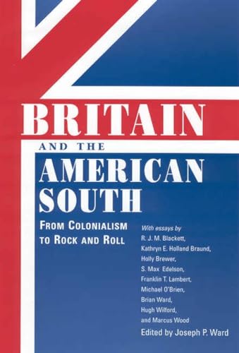
Britain and the American South From Colonialism to Rock and Roll
Buch 3 von 12: Chancellor Porter L. Fortune Symposium in Southern History SeriesAnbieter: Revaluation Books, Exeter, Vereinigtes Königreich
Verkäuferbewertung 5 von 5 Sternen
EUR 57,95
EUR 11,67 Versand
Versand von Vereinigtes Königreich nach USAAnzahl: 2 verfügbar
In den WarenkorbPaperback. Zustand: Brand New. 281 pages. 8.75x5.75x0.75 inches. In Stock.
-

EUR 43,04
EUR 48,99 Versand
Versand von Deutschland nach USAAnzahl: Mehr als 20 verfügbar
In den WarenkorbZustand: New. Edelson examines the relationships between planters, slaves, and the natural world they colonized to create the Carolina Lowcountry. With a bold interdisciplinary approach, Plantation Enterprise reconstructs the environmental, economic, and cultural changes.
-

EUR 43,31
EUR 48,99 Versand
Versand von Deutschland nach USAAnzahl: Mehr als 20 verfügbar
In den WarenkorbZustand: New. In 1763 British America stretched from Hudson Bay to the Keys, from the Atlantic to the Mississippi. Using maps that Britain created to control its new lands, Max Edelson pictures the contested geography of the British Atlantic world and offers new explanat.
-

EUR 53,70
EUR 48,99 Versand
Versand von Deutschland nach USAAnzahl: Mehr als 20 verfügbar
In den WarenkorbZustand: New. Über den AutorPaul S. Sutter (Editor) PAUL S. SUTTER is an associate professor of history at University of Colorado, Boulder. He is the author of Driven Wild: How the Fight against Automobiles Launched the Modern Wild.
-

Plantation Enterprise in Colonial South Carolina
Sprache: Englisch
Verlag: Harvard University Press Mai 2011, 2011
ISBN 10: 0674060229 ISBN 13: 9780674060227
Anbieter: AHA-BUCH GmbH, Einbeck, Deutschland
Verkäuferbewertung 5 von 5 Sternen
Taschenbuch. Zustand: Neu. Neuware - Reinterprets one of America's oldest symbols - the southern slave plantation. This title examines the relationships between planters, slaves, and the natural world they colonized to create the Carolina Lowcountry.
-

The New Map of Empire : How Britain Imagined America Before Independence
Sprache: Englisch
Verlag: Harvard University Press Apr 2017, 2017
ISBN 10: 0674972112 ISBN 13: 9780674972117
Anbieter: AHA-BUCH GmbH, Einbeck, Deutschland
Verkäuferbewertung 5 von 5 Sternen
Buch. Zustand: Neu. Neuware - In 1763 British America stretched from Hudson Bay to the Keys, from the Atlantic to the Mississippi. Using maps that Britain created to control its new lands, Max Edelson pictures the contested geography of the British Atlantic world and offers new explanations of the causes and consequences of Britainżs imperial ambitions before the Revolution.
-

EUR 113,05
EUR 48,99 Versand
Versand von Deutschland nach USAAnzahl: Mehr als 20 verfügbar
In den WarenkorbZustand: New. Über den AutorPaul S. Sutter (left) is an associate professor of history at the University of Georgia and editor of the series Environmental History and the American South. He is author of Driven Wild: How the Fight against Automobi.