

Gesamtpreis (1 Artikel Artikel):
Versandziel:

martenet simon (3 Ergebnisse)
Direkt zu den wichtigsten Suchergebnissen
Suchfilter
Produktart
- Alle Product Types
- Bücher (3)
- Magazine & Zeitschriften (Keine weiteren Ergebnisse entsprechen dieser Verfeinerung)
- Comics (Keine weiteren Ergebnisse entsprechen dieser Verfeinerung)
- Noten (Keine weiteren Ergebnisse entsprechen dieser Verfeinerung)
- Kunst, Grafik & Poster (Keine weiteren Ergebnisse entsprechen dieser Verfeinerung)
- Fotografien (Keine weiteren Ergebnisse entsprechen dieser Verfeinerung)
- Karten (Keine weiteren Ergebnisse entsprechen dieser Verfeinerung)
- Manuskripte & Papierantiquitäten (Keine weiteren Ergebnisse entsprechen dieser Verfeinerung)
Zustand Mehr dazu
- Neu (Keine weiteren Ergebnisse entsprechen dieser Verfeinerung)
- Wie Neu, Sehr Gut oder Gut Bis Sehr Gut (Keine weiteren Ergebnisse entsprechen dieser Verfeinerung)
- Gut oder Befriedigend (1)
- Ausreichend oder Schlecht (2)
- Wie beschrieben (Keine weiteren Ergebnisse entsprechen dieser Verfeinerung)
Einband
- alle Einbände
- Hardcover (3)
- Softcover (Keine weiteren Ergebnisse entsprechen dieser Verfeinerung)
Weitere Eigenschaften
- Erstausgabe (1)
- Signiert (Keine weiteren Ergebnisse entsprechen dieser Verfeinerung)
- Schutzumschlag (Keine weiteren Ergebnisse entsprechen dieser Verfeinerung)
- Angebotsfoto (2)
Sprache (1)
Preis
- Beliebiger Preis
- Weniger als EUR 20 (Keine weiteren Ergebnisse entsprechen dieser Verfeinerung)
- EUR 20 bis EUR 45 (Keine weiteren Ergebnisse entsprechen dieser Verfeinerung)
- Mehr als EUR 45
Gratisversand
Land des Verkäufers
Verkäuferbewertung
-
Martenet's Map of Maryland and District of Columbia, including a sketch of Delaware and parts of Pennsylvania, Virginia, and West Virginia
Verlag: J.L. Smith, Philadelphia, 1885
Erstausgabe
Hardcover. Zustand: Fair. First. First edition. Philadelphia: J. L. Smith, 1885. Lithographed map (46 7/16" x 74") with hand-color in outline. Dissected and laid down on linen in 32 panels. Bound in the publisher's brown cloth with a blind border. Title gilt to the front board. Nearly disbound; the spine perished and the front board detached (with some losses at the fore); the rear board precarious. Each panel tanned peripherally. Split at the top-left and top-right sections, with smaller splits throughout. Losses at five central intersections, as well as along the lower edge of the map. Simon J. Martenet (1832-1892) was the City Surveyor of Baltimore for 16 years from 1867 to 1883. Martenet had published a version of the map in 1865, but considered the present map -- richly revised and augmented -- a distinct work. Mandated by the legislature to be used in schools, the wall-size map depicts the state of Maryland within its broader context (including insets of Hagerstown, Cumberland, Frederick City, Annapolis, Cambridge, Easton, Chestertown, Baltimore (including wards), Washington D.C. and Salisbury). Situated between the metropolises of Washington, Baltimore, and Philadelphia, Maryland had always benefited from the connections -- particularly railroads -- among these cities, but by the 1880's, the Industrial Revolution had completely changed the landscape of the state. Baltimore and Washington were expanding rapidly, with governmental power being consolidated in Washington and Baltimore experiencing a manufacturing boom: its population of 500,000 -- not far below its present size -- staffed some 4,000 factories. Baltimore's new industrial prowess meant that it needed connections to outlying areas, including rural areas that had long been isolated. Maryland's own homegrown railroad, the Baltimore & Ohio (B&O), grew from one of America's first rail lines into a massive railroad giant stretching across Appalachia. Catalogued by Jonah Kramer.
-
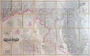
Martenet's Map of Maryland and District of Columbia, Including a Sketch of Delaware and Parts of Pennsylvania, Virginia, and West Virginia
Verlag: J. L. Smith, 1885
Anbieter: Arader Galleries - AraderNYC, New York, NY, USA
Verkäuferbewertung 5 von 5 Sternen

Hardcover. Zustand: Good. Philadelphia: J. L. Smith, [1884] 1885. Large folded map in a quarto binding (46 1/2" x 73 1/2"). With hand-colored engraved map in 32 sections laid on publisher's linen and mounted in partial covers. Bound in publisher's brown cloth with gilt title to front board and marbled endpapers. Boards worn and spine starting. Tanning at folded seams with stains to the verso. Simon J. Martenet (1832-1892) was an American surveyor, mapmaker and real estate consultant who was born in Baltimore to a German mother and Swiss father. In 1867, he published an atlas and large map of Maryland, that was so accurate it was used by all the public schools in the state. Between 1856-1886, his company published many atlases and maps that were known for their detail and historical information. He used this information for real estate speculation. This map contains a key at the lower left, presenting 59 different symbols and abbreviations for subjects such as mills, factories, hotels, roads and railroads. There is a table of county populations at the 1880 census and soundings of the Chesapeake and Delaware Bays. Ten city maps are inset, including Anapolis, Baltimore and Washington.
-

Martenet's Map of Maryland, Atlas Edition, Under the Patronage of the Legislature
Erscheinungsdatum: 1866
Hardcover. Zustand: Fair. No Jacket. solid binding, clean un-marked pages, although fragile with a few scattered tears, foxing on covers, brown cloth with gilt, tears and chipping on spine. BP/locked cabinet.


