

Gesamtpreis (1 Artikel Artikel):
Versandziel:

map walker (29 Ergebnisse)
Direkt zu den wichtigsten Suchergebnissen
Suchfilter
Produktart
- Alle Product Types
- Bücher (5)
- Magazine & Zeitschriften (Keine weiteren Ergebnisse entsprechen dieser Verfeinerung)
- Comics (Keine weiteren Ergebnisse entsprechen dieser Verfeinerung)
- Noten (Keine weiteren Ergebnisse entsprechen dieser Verfeinerung)
- Kunst, Grafik & Poster (Keine weiteren Ergebnisse entsprechen dieser Verfeinerung)
- Fotografien (Keine weiteren Ergebnisse entsprechen dieser Verfeinerung)
- Karten (24)
- Manuskripte & Papierantiquitäten (Keine weiteren Ergebnisse entsprechen dieser Verfeinerung)
Zustand Mehr dazu
- Neu (Keine weiteren Ergebnisse entsprechen dieser Verfeinerung)
- Wie Neu, Sehr Gut oder Gut Bis Sehr Gut (Keine weiteren Ergebnisse entsprechen dieser Verfeinerung)
- Gut oder Befriedigend (Keine weiteren Ergebnisse entsprechen dieser Verfeinerung)
- Ausreichend oder Schlecht (Keine weiteren Ergebnisse entsprechen dieser Verfeinerung)
- Wie beschrieben (29)
Einband
Weitere Eigenschaften
- Erstausgabe (5)
- Signiert (Keine weiteren Ergebnisse entsprechen dieser Verfeinerung)
- Schutzumschlag (Keine weiteren Ergebnisse entsprechen dieser Verfeinerung)
- Angebotsfoto (28)
Sprache (1)
Preis
- Beliebiger Preis
- Weniger als EUR 20 (Keine weiteren Ergebnisse entsprechen dieser Verfeinerung)
- EUR 20 bis EUR 45
- Mehr als EUR 45
Gratisversand
- Kostenloser Versand nach USA (Keine weiteren Ergebnisse entsprechen dieser Verfeinerung)
Land des Verkäufers
Verkäuferbewertung
-

Shropshire. (Walker County Map)
Verlag: London.Published by Longman, Rees, Orme. n.d. [1840?], 1840
Anbieter: J. Patrick McGahern Books Inc. (ABAC), Ottawa, ON, Kanada
Verkäuferbewertung 4 von 5 Sternen

Hardcover. folding linen backedcolour map of Shropshire, 42x 34.5cm, folding to: 12x 8.5cm, in theoriginal blind stamped brown cloth gilt titles on the upper cover, wornat the edges, good to very good (gar) ~ partial image.
-
Journal of the Royal Geographical Society , Volume II, 1832. [with maps 'South East portion of Australia during the progress of discovery in the interior of New South Wales to 1832' and 'Western Australia from the latest documents received 1832']
Verlag: John Murray for Royal Geographical Society, London, 1832
Anbieter: Muir Books [Robert Muir Old & Rare Books], PERTH, WA, Australien
Verkäuferbewertung 5 von 5 Sternen

Erstausgabe
Leather. 1st Edition. 1st ed., Volume 2, octavo, full leather binding, gilt decoration to spine, gilt titled red leather spine label, maps, pp (viii), 334. Complete with all 11 maps. Some rubs and scrapes boards, trace of water damage corners of endpapers, foxing to first page of Nile report, also to maps of Africa and Egypt, light staining to margins (only) of New South Wales map. The map of Western Australia in near fine conditon. Amorial bookplate of J.T. Williamson. Very good condition. Maps include John Walker's large folding map of Western Australia whic accompanies Recent Information from Australia with a despatch from Lieut-Governor James Stirling describing the Swan River district, 2 April 1832, and Arrowsmith's large folding map of New South Wales to accompany Allan Cunningham's report of exploration of the interior. Also included: a letter from Captain FitzRoy regarding the Abrolhos Islands, and maps of North Africa, the Egyptian desert, British Guiana, the Maldives, the mouth of the Ganges river, New Zealand, the Virgin Islands, the Upper Nile, west Africa.
-

Memoirs of the Life and Gospel Labours of the Late Daniel Wheeler. With map of by J. & C. Walker
Verlag: Harvey & Darton/Charles Gilpin, London, 1842
Anbieter: Muir Books [Robert Muir Old & Rare Books], PERTH, WA, Australien
Verkäuferbewertung 5 von 5 Sternen
Erstausgabe
J & C Walker (map) (illustrator). 1st edition. 1st ed., 8vo., pp xxviii 793, fold. map, missing f.f.e.p., remains of removed pres. plate for f.e.p.d., ink stain to side edges affecting p. 769 - r.e.p.d., some very light foxing, uncut edges, folding map [4 maps on one sheet] by J & C Walker, good tight copy, or. cl. bds., library number to lower spine, bumped split corners, edges of spine splitting o/w very good condition. Copper-plate engraved map by Walker showing four maps on one sheet, the islands in the South Pacific: Friendly Islands; Sandwich Isles; Society & Harvey Isles; Eimeo & Tahiti. The author was a British Quaker missionary who ".set sail from the Thames on 13 Nov. 1833 in the Henry Freeling, a cutter of 101 tons, purchased and provisioned by private members of the Society of Friends. The ship arrived off Hobart Town on 10 Sept. 1834, and left in December, conveying James Blackhouse and George Washington Walker to Port Jackson and Norfolk Island on her way to Tahiti. During four or five months spent in that island Wheeler held many services, sometimes on board his ship, with the queen and the chiefs, the missionaries, English residents, and the crews of vessels in the harbour. Queen Pomare remitted the Henry Freeling's port dues because Wheeler's was ?a visit of love, and not a trading voyage? She again came to his meetings on the island of Eimeo. Christmas day 1835 was spent in the Sandwich Islands, and the first Quakers' meeting held there, attended by native chiefs, governor, and the queen. At Honolulu the Henry Freeling stayed some time, also at Rarotonga, the Friendly Islands, and Tongataboo. She made the Bay of Islands about a month before Christmas 1836, and on reaching Sydney in January 1837 was sold and the ship's company discharged. The ship's course was entirely without pre-arrangement, and directed from day to day by Wheeler's spiritual intimations. In a letter to a friend he illustrates his sense of divine protection by saying that he has been ashamed even in landing in canoes through the broken surf to use a life-belt which a friend had given him on leaving." (DNB). Wheeler also published a US edition, however, withouth the map. Ferguson 3537.
-
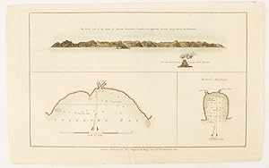
The North side of Queen Charlotte's Islands as it appeared running along shore to the Westward.
Verlag: Alexander Hogg at the King's Arms. [circa1784]., (London)., 1784
Anbieter: Asia Bookroom ANZAAB/ILAB, Canberra, ACT, Australien
Verkäuferbewertung 5 von 5 Sternen
Engraved map in triptych, on laid paper, 20.1 x 32.7 cm, three insets: cross section of the north side of Queen Charlotte's Islands (Solomon Islands) with detail of a volcano "6 leagues North"; Swallow's Bay Harbour; and Byron's Harbour, early hand colour, trimmed to the plate mark at the top edge, neat sealed tear affecting the publisher's caption, slight edge wear and paper toning, but a most attractive map in very good condition. Attractive engraving of the Queen Charlotte's Islands (Solomon Islands). The Islands were named for the consort of King George III, by Philip Carteret, the British naval officer and explorer who participated in two of the Royal Navy's circumnavigation expeditions in 1764?66 and 1766?69. His ship the Swallow gave her name to the Bay, and Carteret's commanding officer on the first of his voyages, John Byron, to the Harbour, depicted in this most attractive early chart.
-
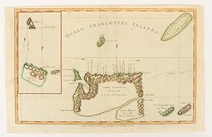
Queen Charlotte's Islands.
Verlag: Alexander Hogg at the King's Arms. [circa1784]., (London)., 1784
Anbieter: Asia Bookroom ANZAAB/ILAB, Canberra, ACT, Australien
Verkäuferbewertung 5 von 5 Sternen
Engraved map on laid paper, 21.4 x 33.7 cm, inset of Gower's, Simson's and Carteret's Island, early outline hand colour, trimmed to the plate mark at the top edge, three small edge tears affecting the upper margin only, slight paper toning, but a most attractive map in very good condition. Fine impression of the Queen Charlotte's Islands (Solomon Islands). It features the Swallow's track, the ship's route taken by Captain Philip Carteret in 1767, the British naval officer and explorer who participated in two of the Royal Navy's circumnavigation expeditions in 1764?66 and 1766?69.
-
Map of the Kingdoms of Siam and Cochin China.
Erscheinungsdatum: 1828
Anbieter: Geographicus Rare Antique Maps, Brooklyn, NY, USA
Verbandsmitglied: ABAA ESA ILAB
Verkäuferbewertung 4 von 5 Sternen
Karte Erstausgabe
Good. Some wear along old fold lines. Repaired and reinforced split along bottom horizontal fold. Some discoloration and repair where originally tabbed into volume, at center. Laid down on archival tissue. Size 37 x 25 Inches. This rare large-format 1828 map of Southeast Asia, compiled by John Walker to illustrate John Crawfurd's mission to Siam (Thailand), is the first accurate survey of the coasts of Siam. Coverage extends from China to Singapore and from the Gulf of Martaban (Burma) to Vietnam and Hainan. Siam at the time was inaccessible to European merchants and even diplomats, with its coasts and interior largely unknown. This map is an amalgam of European sources, but with regard to Siam, it was derived primarily from secretly acquired early 19th-century Siamese surveys previously unknown to Europeans and, for all intents and purposes, still lost. Historical Context Following the resurgence of the Kingdom of Siam after the Burmese-Siamese War (1765 - 1767), Siam emerged as a major political power and the central state in Southeast Asia. The regional destabilization following Siamese victory led to a power vacuum in Burma, which precipitated a series of further conflicts, both between Siam and Burma and between Burma and Great Britain, lasting well into the early 19th century. The British took advantage of the weak Burmese military to seize additional territory in Assam, Manipur, and Arakan during the First Anglo-Burmese War (1824 - 1826). At the same time, Siam continued to grind away at both Burmese territory to the west and parts of Laos and Cambodia to the east, stopped only by Vietnamese and French forces in Indochina. To the south, Britain exerted a strong influence over the Malay States, leaving only Siam as a fully independent and powerful Southeast Asian state resistant to European influence. The Crawfurd Mission The Scottish linguist, diplomat, doctor, and colonial administrator John Crawfurd (1783 - 1868) was sent to the Kingdom of Siam by the Governor-General of India, Lord Francis Edward Rawdon-Hastings (1754 - 1826). Hastings was interested in evaluating the growing power of Siam, acquiring a reliable reconnaissance of Siamese lands, establishing trade relations, and understanding Siamese policy with regard to both the Malay States to the south (particularly Penang, to which the British had laid claim) and to French attempts to establish a colonial presence in Vietnam. While the mission failed to establish trade relations, evaluate Siamese political positions regarding Penang, or explore the interior, Crawfurd did collect cartographic materials detailing the coast, much of which John Walker compiled into this map. The 'Mohammedan Mariner' In the appendix to Crawfurd's Journal of an Embassy from the Governor-General of India to the Courts of Siam and Cochin-China , he lists the sources of this remarkable map. Many are new surveys conducted en route , earlier British surveys of the Malay States and Bengal, and French sources for Indochina, but the bulk of the map as it relates to Siam is based upon cartography passed clandestinely to Crawfurd by a Siamese Muslim navigator. To quote Crawfurd, From the Cape of Patani to the point of Kwiis taken from a Mohammedan mariner, a native of Siam, possessed of considerable intelligence-who was acquainted with the use of maps and the quarterstaff, and could even take an altitude of the sun with our quadrants. he goes on to describe how this same mariner, in fear of his life, divulged less and less information the closer the came to Siam, .a great deal of useful information . as we approached Siam they became much more shy and reserved, and now communicated nothing without a strict injunction to secrecy. They constantly resisted our solicitations to assist in translating the Governor-general's letter into Siamese, observing that the communication of his Majesty's titles would be considered as the divulgement of a state secret, which might cost them their lives. The comman.
-
Birds Eye View of Casco Bay: Portland, Maine and Surroundings.
Erscheinungsdatum: 1950
Anbieter: Geographicus Rare Antique Maps, Brooklyn, NY, USA
Verbandsmitglied: ABAA ESA ILAB
Verkäuferbewertung 3 von 5 Sternen

Karte
Very good. Exhibits wear along original fold lines. Verso repairs and reinforcements at fold intersections. Exhibits an area of infill at a fold intersection. Size 19.5 x 28 Inches. This is a beautiful 1950 bird's eye-view map of Casco Bay, Portland, Maine. It is the last edition of the George Walker view of the same title, first issued in 1906. The view covers Casco Bay, from Port Elizabeth and South Portland with Rangeley Lakes and Mount Washington evident on the horizon. The city of Portland is beautifully rendered. Throughout, the map notes towns, islands, capes, points, and a few other topographical features. The bustling bay is full of ships and ferries traveling between its various islands. As distinct from the original 1906 issue, the title of this edition has been moved from the bottom of the map to the top, and the bottom has been filled with a tour of the region marking such highlights as John Smith's visit in 1614, a hiding spot of Captain Kidd's treasure, and the excellent hotel and cottage accommodations on the principal islands. Publication History This view/map was copyrighted and first issued by Geo H. Walker and Co. in 1906. In and around 1950 the original lithographic stone was used again for this 1950 edition, printed on behalf of the Down-East Sportscraft firm of Freeport, Maine. It appears on the market from time to time but is neglected in institutional collections. We note only one example of this edition in OCLC, at the Osher Map Library at the University of Southern Maine. References: OCLC 1059856737.
-

Part of Map of Boston Proper.
Erscheinungsdatum: 1894
Anbieter: Geographicus Rare Antique Maps, Brooklyn, NY, USA
Verbandsmitglied: ABAA ESA ILAB
Verkäuferbewertung 3 von 5 Sternen
Karte
Very good. Minor wear along original fold lines, especially near center. Professionally flattened and backed with archival tissue. Text on verso. Size 13 x 21 Inches. This is an 1894 George H. Walker and Company city map or plan of Boston, Massachusetts. The map depicts the central part of the city from the intersection of Columbus Avenue and Dartmouth Street to East Boston and from Charlestown to the Point Channel. Highly detailed, myriad streets, buildings, wharves, and other locations are noted throughout the city. Subway, surface, and elevated mass transit lines are illustrated using red overprinting, as are two locations of S.S. Pierce Company Grocers and the Macullar, Parker Company Clothiers store. Boston Common is situated slightly to the left of center, shaded green, with the public garden illustrated just across Charles Street. City wards are identified and numbered. This map was created and published by George H. Walker and Company in 1894 and presented by the Hotel Essex. References: OCLC 46397908.
-

Part of Englewood.
Erscheinungsdatum: 1876
Anbieter: Geographicus Rare Antique Maps, Brooklyn, NY, USA
Verbandsmitglied: ABAA ESA ILAB
Verkäuferbewertung 3 von 5 Sternen
Karte
Good. Even overall toning. Original centerfold exhibits some wear and in verso reinforcement. Minor discolorations here and there. Edge wear mostly confined to margins. Size 16.75 x 27.25 Inches. Very detailed 1876 map of northeastern Englewood (part 1 of 2), showing roads and property owners' names, and building footprints. Published as plates 64-65 in Walker & Pease' exquisite 'topographical, illustrated, historical, descriptive' Atlas of Bergen County, New Jersey , 1876. On verso appear similar maps of Highland, Floraville, and Teaneck, all in Englewood and Ridgefield Townships. References: Phillips (Atlases) #2152.
-

Property of Wm. Walter Phelps, I.S. Homans, and Others, newar Englewood, New Jersey.
Erscheinungsdatum: 1876
Anbieter: Geographicus Rare Antique Maps, Brooklyn, NY, USA
Verbandsmitglied: ABAA ESA ILAB
Verkäuferbewertung 3 von 5 Sternen
Karte
Good. Even overall toning. Original centerfold exhibits some wear and in verso reinforcement. Minor discolorations here and there. Edge wear mostly confined to margins. Size 16.75 x 27.25 Inches. Detailed map of property owners near Englewood, New Jersey, incl. Phelps and Homans. Insets of New Bridge and River Edge. Published as plates 76-77 in Walker & Pease' exquisite 'topographical, illustrated, historical, descriptive' Atlas of Bergen County, New Jersey , 1876. Blank on verso. References: Phillips (Atlases) #2152.
-

Part of Englewood.
Erscheinungsdatum: 1876
Anbieter: Geographicus Rare Antique Maps, Brooklyn, NY, USA
Verbandsmitglied: ABAA ESA ILAB
Verkäuferbewertung 3 von 5 Sternen
Karte
Good. Even overall toning. Original centerfold exhibits some wear and in verso reinforcement. Minor discolorations here and there. Edge wear mostly confined to margins. Size 16.75 x 27.25 Inches. Very detailed 1876 map of the eastern-most portion of Englewood, showing roads and property owners' names, and building footprints. Published as plates 72-73 in Walker & Pease' exquisite 'topographical, illustrated, historical, descriptive' Atlas of Bergen County, New Jersey , 1876. Blank on verso. References: Phillips (Atlases) #2152.
-

Englewood.
Erscheinungsdatum: 1876
Anbieter: Geographicus Rare Antique Maps, Brooklyn, NY, USA
Verbandsmitglied: ABAA ESA ILAB
Verkäuferbewertung 4 von 5 Sternen
Karte
Good. Even overall toning. Original centerfold exhibits some wear and in verso reinforcement. Minor discolorations here and there. Edge wear mostly confined to margins. Size 16.75 x 27.25 Inches. Very detailed 1876 map of Englewood Township, New Jersey, showing roads, property boundaries, and owners' names. Notable too is the early depiction of school district boundaries in a state that today publicizes the high quality of its schools in the context of property values. Published as plates 60-61 in Walker & Pease' exquisite 'topographical, illustrated, historical, descriptive' Atlas of Bergen County, New Jersey , 1876. On verso appear absolutely lovely lithographic views of the residence of Judge Henry H. Voorhis, a house for sale, HE & J Taylor's Stables, Carriage Factory of George de Baun. References: Phillips (Atlases) #2152.
-

Fairmount.
Erscheinungsdatum: 1876
Anbieter: Geographicus Rare Antique Maps, Brooklyn, NY, USA
Verbandsmitglied: ABAA ESA ILAB
Verkäuferbewertung 4 von 5 Sternen
Karte
Good. Even overall toning. Original centerfold exhibits some wear and in verso reinforcement. Minor discolorations here and there. Edge wear mostly confined to margins. One large repaired tear from left margin extinding 2 inches into page. Size 16.75 x 27.25 Inches. Exquisitely detailed and charming lithographic views of various unnamed buildings surround a map of Fairmount, New Barbadoes Township, New Jersey. Most of the views focus on the properties and lands of G. N. Zingsem, the architect renowned for designing Fairmount Park in Philadelphia. Today Fairmont enjoys an unusual diversity of flora due to Zingsem's importation of various Elms, poplar, Cedar, and Capalpa trees into the region. The grand Fairmont Hotel, destroyed by fire in 1925, appears in the lower left quadrant. An almost identical map without views graces the verso. Published in Walker & Pease' exquisite 'topographical, illustrated, historical, descriptive' Atlas of Bergen County, New Jersey , 1876. References: Phillips (Atlases) #2152.
-

Norwood, Hillsdale, Palisade Land Co.
Erscheinungsdatum: 1876
Anbieter: Geographicus Rare Antique Maps, Brooklyn, NY, USA
Verbandsmitglied: ABAA ESA ILAB
Verkäuferbewertung 3 von 5 Sternen
Karte
Good. Even overall toning. Original centerfold exhibits some wear and in verso reinforcement. Minor discolorations here and there. Edge wear mostly confined to margins. Size 17 x 13.75 Inches. Maps of Norwood (plate 107), the property of the Palisade Land Co. (plates 108-109), and Hillsdale, NJ, showing property boundaries and owner names. Notable too is that depiction of school district boundaries-- even at this early date New Jersey schools were being highlighted in the context of property (and presumably property values), a practice that continues to this day. Published in Walker & Pease' exquisite centennial 'topographical, illustrated, historical, descriptive' Atlas of Bergen County, New Jersey , 1876. Note, image above represents the verso and recto (front and back) of a single sheet of paper. References: Phillips (Atlases) #2152.
-

Part of Tenafly, Palisade Township.
Erscheinungsdatum: 1876
Anbieter: Geographicus Rare Antique Maps, Brooklyn, NY, USA
Verbandsmitglied: ABAA ESA ILAB
Verkäuferbewertung 3 von 5 Sternen
Karte
Good. Even overall toning. Original centerfold exhibits some wear and in verso reinforcement. Minor discolorations here and there. Edge wear mostly confined to margins. Size 16.75 x 27.25 Inches. Vividly detailed 1876 map of Tenafly, Palisade Township, New Jersey, showing roads and property owners' names. Published as plates 88-89 in Walker & Pease' exquisite 'topographical, illustrated, historical, descriptive' Atlas of Bergen County, New Jersey , 1876. Similar maps of Demarest, Overton and New Milford appear on verso. References: Phillips (Atlases) #2152.
-

Massachusetts Atlas Plate No. 12.
Erscheinungsdatum: 1907
Anbieter: Geographicus Rare Antique Maps, Brooklyn, NY, USA
Verbandsmitglied: ABAA ESA ILAB
Verkäuferbewertung 4 von 5 Sternen
Karte
Very good. Repaired tear extending ten inches from left margin. Blank on verso. Still attached to original booklet. Size 20 x 27.5 Inches. This is a 1907 George Walker and Company pocket map of southern Cape Cod, Massachusetts. The map depicts from Marion to Hyannis and from Bourne to Nantucket Sound and Vineyard Sound. Several counties are labeled, including Marion, Bourne, Falmouth, and Barnstable as well as Cape Cod Bay, Nantucket Sound, Vineyard Sound, and Buzzard Bay. The Cape Cod Division of the New York, New Haven, and Hartford Railroad is depicted, along with numerous roads. Ponds and hills are labeled. Along the bottom border, a legend explains the different notations utilized throughout the map, including the difference between town and county borders and that the abbreviation P.O. after a town name indicates the presence of a post office. This map was published by George H. Walker and Company in Boston in 1907.
-

Boston Harbor.
Erscheinungsdatum: 1925
Anbieter: Geographicus Rare Antique Maps, Brooklyn, NY, USA
Verbandsmitglied: ABAA ESA ILAB
Verkäuferbewertung 3 von 5 Sternen
Karte
Very good. Light wear along original fold lines. Reinforced where previously attached to binder. Size 13 x 21.5 Inches. This is a c. 1927 George H. Walker and Company bird's-eye view map of Boston Harbor. South Boston occupies the center of the foreground, with a few major streets identified, along with Commonwealth Pier, Pleasure Bay, and Fort Independence on Castle Island. Sailing ships crowd the water between Dorchester Bay and Old Boston Harbor. East Boston, with its many wharves and airport, appear in the foreground on the left. Numerous islands dot the harbor as it stretches toward the horizon. Forts, lighthouses, and other buildings are illustrated on some of these islands. The route of the Nantasket Beach Line Steamers appears as a dashed line, along with the Main Ship Channel between Fort Revere and Boston Light. Publication History and Census This view was published by George H. Walker and Company c. 1927. Walker and Company published similar views of Boston Harbor as early as 1897, many of which were sold by newsboys on the harbor's ferries.
-
![Bild des Verkäufers für Map of the Coast of Maine [Western Part]. zum Verkauf von Geographicus Rare Antique Maps](https://pictures.abebooks.com/inventory/md/md32068505786.jpg)
Map of the Coast of Maine [Western Part].
Erscheinungsdatum: 1893
Anbieter: Geographicus Rare Antique Maps, Brooklyn, NY, USA
Verbandsmitglied: ABAA ESA ILAB
Verkäuferbewertung 3 von 5 Sternen
Karte
Good. Verso repairs to fold separations and at fold intersections. Exhibits slight loss at some fold intersections. Accompanied by original binder. Size 20.75 x 31 Inches. This is an 1893 George H. Walker map of the western section of the coast of Maine. The map depicts from Kittery east to Lincolnville and from Norway Lake and Snows Falls south to the Atlantic Ocean. Red overprinting highlights bicycle routes that meander through most of the region, including a coastal route. Bicycling in Maine in the late 19th century In the late 19th century, bicycling was popular throughout the United States. In Portland alone, there were more than forty bicycle stores by 1896. Dozens of bicycling clubs throughout the state organized tours. In his dissertation Pedaling Vacationland: Bicyclists, Genteel Recreation, and the Maine Landscape, 1878 1902 , Sam Shupe details the importance of Maine's bicycling culture and the reputation it gained not just in the northeast but across the country. Publication History and Census This map was created and published by George H. Walker in 1893. A single example is cataloged in OCLC, part of the institutional collection at Cornell University. References: Shupe, S.D. Pedaling Vacationland: Bicyclists, Genteel Recreation, and the Maine Landscape, 1878 - 1902. (Boston University, PhD Dissertation). OCLC 6901076.
-

Narragansett Bay.
Erscheinungsdatum: 1900
Anbieter: Geographicus Rare Antique Maps, Brooklyn, NY, USA
Verbandsmitglied: ABAA ESA ILAB
Verkäuferbewertung 4 von 5 Sternen
Karte
Good. Light wear along original fold lines. Areas of infill in top and bottom margin. Slight area of infill along top border. Light toning and soiling. Size 20 x 27 Inches. This is an uncommon c. 1900 George H. Walker bird's-eye view map of Narragansett Bay, Rhode Island. This is one of a series of view and maps published by Walker, among others, to serve the on-board and in-terminal newsstand market. The views were sold as souvenirs as well as practical guides to the journey. A Closer Look The view depicts the entirety of Narragansett Bay, from Point Judith to Providence, and extends eastward as far as Warren Point and Sakonnet. It identifies Newport, Conanicut Island, Prudence Island, Rhode Island, and various settlements along the bay's shoreline. Ferry routes crisscross the bay and lighthouses are illustrated in profile. Railroads appear as well, including the New York, New Haven, and Hartford Railroad. Publication History and Census This map was produced by Boston map publisher George H. Walker and published c. 1900 by the Rhode Island News Co. of Providence, Rhode Island. Walker is better known for his similar view maps of Boston Harbor - the present example is thus somewhat out of his focus area and very scarce. We note five examples cataloged in OCLC which are part of the collections at the New York Public Library, Brown University, Harvard University, the State Library of Massachusetts, and the University of California Santa Barbara. References: OCLC 36488389.
-
Rhode Island / Road map of Rhode Island showing all the roads and points of interest, with the cycling roads distinguished by red lines.
Erscheinungsdatum: 1898
Anbieter: Geographicus Rare Antique Maps, Brooklyn, NY, USA
Verbandsmitglied: ABAA ESA ILAB
Verkäuferbewertung 3 von 5 Sternen
Karte Erstausgabe
Very good. Slight wear on old fold lines. Accompanies original binder. Size 30 x 25.5 Inches. A scarce and lovely c. 1898 folding map of Rhode Island prepared by the prolific New England map publisher George Walker. It highlights features around the state, including Narragansett Bay and Newport, summertime destination for America's crème de la crème . A Closer Look Coverage includes Rhode Island and adjacent waters, along with portions of Connecticut and Massachusetts. Towns and cities are noted, along with roads, railroads, steamship lines (which could be more convenient for certain destinations, such as Newport), waterways, islands, lighthouses, and administrative boundaries. The 'best routes' for travelers are traced in red. An inset of Block Island appears at bottom-right. The sheer density of rail lines, many belonging to the 'New York, New Haven and Hartford Railroad', demonstrates the dominance of that mode of transportation. In the following years, streetcars and interurban trolleys would also connect many of the cities seen here. Narragansett Bay Like other coastal communities along the shores of New England, Narragansett Bay was primarily a site of trade and fishing for centuries, before adopting tourism and leisure activities in the late 19th century. With the help of steamships and railroads, the wealthy classes of Boston, New York, and other cities recognized the natural beauty and preferable climate of Narragansett Bay as an escape from the heat and grime of the urban summer. Newport, towards bottom-right, became a summer retreat for America's elite, who built magnificent mansions along the coast. Publication History and Census This map was prepared by George Walker and Co. (here as 'Walker Lith. and Pub. Co.') in Boston. It is undated but, from context, appears to be from the very late 19th century (Harvard's Map Collection dates it to 1898). Later editions of the map published in 1905 and 1909 are dated. The existence of multiple editions has led to some confused cataloging, but the map is scarce regardless of edition. Only Harvard appears to hold the first edition of the map, making this an especially rare find. References: Harvard Map Collection MAP-LC G3770 1898 .G4.
-

Boston Harbor.
Erscheinungsdatum: 1897
Anbieter: Geographicus Rare Antique Maps, Brooklyn, NY, USA
Verbandsmitglied: ABAA ESA ILAB
Verkäuferbewertung 4 von 5 Sternen
Karte
Very good. Creasing along fold lines. Size 14 x 19.5 Inches. An uncommon 1897 early example of a George H. Walker aquatint view of Boston Harbor. It presents the city and harbor as teeming with activity, a testament to Boston's dynamism at the turn of the 20th century. A Closer Look Centered on South Boston and oriented towards the southeast, the view depicts Boston Harbor from East Boston and Nahant eastward as far as Squantum and Slate Island. The bustling harbor is illustrated full of ships and ferries traveling between various islands and cities (views such as this were sold and given to customers of various Boston-based ferry services). Islands throughout the harbor are illustrated, including Thompson's Island, Castle Island, Spectacle Island, Governors Island, Deer Island, Lovell's Island, Calf Island, and Peodock's Island. Various lighthouses are illustrated and labeled, including Boston Light, Bug Light, and Minots Ledge Light. Continuity and Change Walker published this view in several editions from 1897 and until around 1925 (see 'Publication History and Census below). Comparing this early edition to a late c. 1925 edition (previously sold by us) reveals changes in the cityscape. Though the two are superficially nearly identical, a close examination demonstrates several minor but notable changes. Most noticeably, the 1925 edition expands the scope slightly to the right (westwards) to include Hough's Neck, the Fore River Shipyard, and other points along the coastline in Quincy. East Boston is also more filled in, with land reclamation significantly expanding the area of usable land, including the addition of what would eventually become Logan International Airport. Some changes are also recognizable in Boston proper, such as the Custom House Tower, the tallest building in the city when completed in 1915. Even minute details, such as the upgrading of a bridge on Dorchester Ave. near South Station, were updated for accuracy. Publication History and Census George H. Walker and Co. published this view in several editions (not all of which are dated) in the late 19th and early 20th century, up to around 1925. This dated 1897 edition appears to be the earliest. It is not listed in the OCLC, though the Library of Congress looks to hold a slightly modified printing of the same edition (OCLC 925600125).
-

Map of the Railroads of the State of Massachusetts Accompanying the Report of the Railroad Commissioners Corrected to January 1, 1909.
Erscheinungsdatum: 1908
Anbieter: Geographicus Rare Antique Maps, Brooklyn, NY, USA
Verbandsmitglied: ABAA ESA ILAB
Verkäuferbewertung 4 von 5 Sternen
Karte
Very good. Exhibits light wear along original fold lines. Lower left margin extended. Exhibits tiny areas of infill. Size 26.25 x 34.25 Inches. This is a 1908 George Walker railroad map of Massachusetts. Colored lines trace railroads throughout. The red lines highlight the network of the Boston and Maine Railroad, while green follows the Boston and Albany Railroad, and blue the New York, New Haven, and Hartford Railroad. Other colored lines illustrate the networks of the Chester and Becket Railroad, the Central New England Railroad, the Grafton and Upton Railroad, and the New England Northern Railroad. Cities and towns throughout are labeled, and mileage from Boston to various cities provided. An inset in the upper right details the region surrounding Boston and the Boston and Maine, Boston and Albany, and New York, New Haven, and Hartford rail networks in that area. Publication History and Census This map was created and published by the Walker Lithographing and Publishing Company and printed by the Wright and Potter Printing Company of Boston. References: OCLC 497900199.
-
Catalogue of Road Maps, City Maps, and Atlases, Published by Geo. H. Walker and Co.
Erscheinungsdatum: 1898
Anbieter: Geographicus Rare Antique Maps, Brooklyn, NY, USA
Verbandsmitglied: ABAA ESA ILAB
Verkäuferbewertung 3 von 5 Sternen
Karte
Very good. Twenty-four page booklet. Size 6.25 x 3.5 Inches. An interesting bit of cartographic ephemera, this is the c. 1898 George H. Walker and Company twenty-four-page catalog of maps, atlases, and other related products. A prolific Boston-based map publisher, this catalog provides an overview of a successful map publisher's output and a glimpse of how maps were sold and advertised around the turn of the 20th century. A Closer Look An index of atlases, wall maps, pocket maps, pocket railroad maps, and pocket road maps precedes the catalog proper and provides the place, page number, and price for each product. Then the catalog begins with a few short explanations followed by 19 pages filled with descriptions of maps that include the price, type (wall map, pocket map, atlas, etc.), and a short description. Publication History and Census This catalog was created and published by George H. Walker and Company c. 1898. We note a single cataloged example: University of Massachusetts Amherst. Per the OCLC entry, the Amherst example bears the imprint: 'For sale by H.L. De Blaeu, Bookseller, Stationer and NewsdealerAlbany, N.Y.' The presently offered example bears a similar but different imprint: 'For Sale by Boston Map Store. 'Old Corner Book Store'Boston, Mass.' This underscores how such catalogs were distributed. References: OCLC 21915173.
-
Map of Cape Cod and Vicinity.
Erscheinungsdatum: 1902
Anbieter: Geographicus Rare Antique Maps, Brooklyn, NY, USA
Verbandsmitglied: ABAA ESA ILAB
Verkäuferbewertung 4 von 5 Sternen
Karte
Very good. Minor verso reinforcement along some old fold lines and intersections. Light toning along old fold lines. Detached but accompanied by original binder. Size 30.5 x 28 Inches. A charming 1902 map of Cape Cod, Nantucket, Martha's Vineyard, and other points along the coast of Massachusetts, published by George H. Walker and Company. Rich in information, it focuses in particular on cycling routes, reflecting the boom in recreational cycling in the preceding years. A Closer Look The map depicts the region from New Bedford east to the Atlantic Ocean and from Duxbury and Provincetown south to Nantucket. Cycling routes are traced in red, with further connections to Boston, Quincy, Taunton, and Fall River suggested, indicating the main selling point of the map. Other roads, railroad lines, and ferry and steamship lines are also noted, providing comprehensive transportation information to the traveler and local alike. Town borders are outlined in orange. Waterways, swamps, shoals, and other maritime and coastal features are also illustrated. The Bicycle Boom Though invented in the early 19th century, bicycles only became commercially accessible and popular in the closing decades of the 19th century. A range of innovations made the machines more reliable, safe, comfortable, and affordable, and they became fashionable for their applications in transportation, leisure, and sport on both sides of the Atlantic. As would later happen with automobiles, cycling clubs sprang up to scour best routes, advocate for improved roads, and connect enthusiasts (for instance, the Massachusetts Bicycle Club was founded in 1879 in Boston). Cycling was particularly popular among women, as it provided freedom of movement and association (the sexes could intermingle without parental oversight). With regard to the present map, the quaint small towns and seaside roads of Cape Cod, Nantucket, and Martha's Vineyard were especially well-suited for bicycles. Publication History and Census This map was created and published by George H. Walker and Company in 1902, updating an earlier 1892 map. Yale University and the American Antiquarian Society list the 1892 edition among their holdings, but we are unable to locate any examples of the 1902 edition in institutional collections or on the market.
-
Map of Cape Cod and Vicinity 1892.
Erscheinungsdatum: 1892
Anbieter: Geographicus Rare Antique Maps, Brooklyn, NY, USA
Verbandsmitglied: ABAA ESA ILAB
Verkäuferbewertung 3 von 5 Sternen
Karte
Good. Some discoloration along old fold lines. Infill in the lower right, northeast of Nantucket, and here and there at fold intersections. Tape residue and infill along fold at upper left corner. Stabilized on archival tissue. Size 28.25 x 32.75 Inches. A lovely 1892 George H. Walker map of Cape Cod, Martha's Vineyard, Nantucket, and environs. It was produced to capitalize on the bicycle craze of the late 19th century, which revolutionized transportation and opened new possibilities for women's independence. A Closer Look The map depicts from New Bedford east to the Atlantic Ocean and from Duxbury and Provincetown south to Nantucket. Red lines mark the borders of towns, and roads are traced and labeled throughout. Railroad lines and ferry and steamship lines are also noted, providing comprehensive transportation information to travelers and locals alike. Waterways, swamps, shoals, lighthouses, and other maritime and coastal features are also recorded. The Turn of the Century Bicycle Boom Though invented in the early 19th century, bicycles only became commercially accessible and popular in the closing decades of the 19th century. At first, 'penny-farthing' or high-wheeled bicycles became popular in the 1870s and 1880s, but they tended to be dangerous and uncomfortable to ride. A range of innovations in the following years made the machines more reliable, safe, comfortable, and affordable, and they became fashionable for their applications in transportation, leisure, and sport on both sides of the Atlantic. As would later happen with automobiles, cycling clubs sprang up to scour for the best routes, advocate for improved roads, and connect enthusiasts (for instance, the Massachusetts Bicycle Club was founded in 1879 in Boston). With regard to the present map, the quaint small towns and seaside roads of Cape Cod, Nantucket, and Martha's Vineyard were especially well-suited for bicycles. Cycling was particularly popular among women, as it provided freedom of movement and association outside of the home. At first, penny-farthings were preferred by men, while modern bicycles, dubbed 'safety bicycles,' were marketed towards women. The bicycle craze peaked in the 1890s and was an early example of American consumer culture, with products explicitly marketed towards women. The popularity of cycling among women set off a range of cultural changes; for instance, the elaborate Victorian dress was scaled down to allow women the freedom of movement to ride bicycles, resulting in shorter skirts and bloomers, which were effectively pants. Some historians even credit the bicycle as prompting a wider push for women's rights and suffrage. Publication History and Census This map was created and published by George H. Walker and Company in 1892; a 1902 edition (also sold by us) was later issued, as was a 1907 edition. Regardless of edition, the map is rare, with the present edition being listed in the OCLC among the holdings of Yale University, the American Antiquarian Society, Harvard University, the Boston Athenaeum, the State Library of Massachusetts, Williams College, Princeton University, and the National Library of Australia. References: OCLC 913849202, 57016157, 219812642.
-

City of New-York.
Erscheinungsdatum: 1848
Anbieter: Geographicus Rare Antique Maps, Brooklyn, NY, USA
Verbandsmitglied: ABAA ESA ILAB
Verkäuferbewertung 4 von 5 Sternen
Karte
Very good. Removed from original binder (included) and backed with archival tissue for stability. Stored flat. Minor wear and toning on original fold lines. Size 23 x 18 Inches. A scarce 1848 pocket map of the city of New York by William Kemble and Edward Walker. A Closer Look This map is much updated, enlarged, and expanded revision of the 1833 New York map of David H. Burr. Coverage embraces from 26th street on the west side and 40th street on the east side south as far as the Batter. Parts of adjacent Brooklyn, including Williamsburg, Brooklyn Heights, and Fort Green are also included. City wards are number and color coded, all streets are identified, and countless important buildings are noted. Ferry routes cross the East and Hudson Rivers in numerous places. The map is gridded in quarter-mile sections. The map notes the original site of Columbia College near Park Place as well as the current site of New York University near Washington Square Park. Churches, theaters, and public baths area also identified throughout. A major elaboration over the Burr edition is the dramatic expansion of the Brooklyn portion of the map beyond the original map's border as far as DeKalb Street to account for the development of Fort Green Park and the surrounding streets. Also of interest is a revision to include both Masonic and Odd Fellows Lodges. A note in the lower left acts as a key to identifying these establishments. Walker was an Odd Fellow and may have been a Mason as well - hence this unusual addition to the original Burr plate. Publication History and Census This map was created and published by William Kemble and Edward Walker in 1848. It is notably much rarer than the earlier edition by Burr, which enjoyed quite a long and substantial run. The OCLC identifies only 4 examples in institutional collections. References: OCLC: 18803986. New York Public Library, Map Division, Map Div. 01-1822. Haskell, D., Manhattan Maps A Co-operative List, 900 (1846).
-

Trolley Pathfinder Birds Eye Map of Interurban Trolley Lines in New England.
Erscheinungsdatum: 1905
Anbieter: Geographicus Rare Antique Maps, Brooklyn, NY, USA
Verbandsmitglied: ABAA ESA ILAB
Verkäuferbewertung 4 von 5 Sternen
Karte
Very good. Verso repairs to fold separations. Closed tear extending one-quarter (1/4) inch into printed area from top margin professionally repaired on verso. Reinforced where once attached to booklet. Accompaniedbybooklet. Size 14 x 20 Inches. This is a vivid 1905 chromolithograph bird's-eye view style pocket map of New England by George Walker issued for the Metropolitan News Company. It was issued to promote the extensive but ephemeral New England interurban streetcar network of the early 20th century. A Closer Look Centered on Boston and oriented with north to the right, the map reveals New England from Portsmouth to New York City and Long Island, excluding Cape Cod. It features the extensive trolley lines connecting major New England cities and towns including Boston, Providence, Brockton, Plymouth, Manchester, Springfield, Portsmouth, Worchester, Hartford and others. It also notes railway lines, parks, lakes, rivers and other geographic features. Interurban Streetcars At the end of the 19th century, New England was serviced by an extensive network of interurban electric and steam powered streetcars. These were not proper railroads, but rather a separate system, run by various competing companies, that extended from New York to Boston and throughout New England as far north as Bath and Lewiston, Maine. By 1919, most of the interurban streetcar lines were consolidated under the Shore Line Electric Railway. The rise of the automobile ushered in the end of interurban streetcar travel by 1940. Chromolithography Chromolithography is a color lithographic technique developed in the mid-19th century. The process involved using multiple lithographic stones, one for each color, to yield a rich composite effect. Oftentimes, the process would start with a black basecoat upon which subsequent colors were layered. Some chromolithographs used 30 or more separate lithographic stones to achieve the desired product. Chromolithograph color could also be effectively blended for even more dramatic results. The process became extremely popular in the late 19th and early 20th centuries, when it emerged as the dominant method of color printing. The vivid color chromolithography produced made it exceptionally effective for advertising and propaganda imagery. Publication History and Census This map was created by George H. Walker and published by the Metropolitan News Company in 1905. Stylistically it is very similar to Trolley Wayfinder Birds Eye View of Trolley Routes in New England , published in the same year, also by Walker, but focused more broadly. It is held by six institutions in the United States (the Connecticut State Library, the Connecticut Historical Society, the Boston Public Library, Brown University, Harvard University, and Southern Methodist University) and is scarce to the market. References: OCLC 1295610993, 36486343.
-
New Driving Road Map of Essex County, Mass.
Erscheinungsdatum: 1884
Anbieter: Geographicus Rare Antique Maps, Brooklyn, NY, USA
Verbandsmitglied: ABAA ESA ILAB
Verkäuferbewertung 4 von 5 Sternen
Karte
Very good. Light wear along original fold lines. Very slight loss at fold intersections. Size 25.25 x 33 Inches. This is an 1884 George Walker map of Essex County, Massachusetts. The map details the North Shore region, including Cape Ann, Gloucester, Essex, Lawrence, Salem, Newburyport, and Lynn. The county's road and railroad network appears in detail, noting the 'Gloucester, Essex, and Lawrence' branches of the 'Eastern Railroad', the 'Newburyport Railroad', the 'Boston and Maine Railroad', and the 'Salem and Lowell Railroad'. Publication History and Census This map was created and published by George H. Walker in 1884. We note seven examples in OCLC: American Antiquarian Society, Harvard University, the Boston Athenaeum, the State Library of Massachusetts, Salem State University, and the Wisconsin Historical Society. References: OCLC 11026512.
-
To Her Most Gracious Majesty Queen Victoria, This Map of the World on Mercator's Projection, is most respectfully dedicated, by Her devoted Subjects J. and C. Walker.
Erscheinungsdatum: 1840
Anbieter: Geographicus Rare Antique Maps, Brooklyn, NY, USA
Verbandsmitglied: ABAA ESA ILAB
Verkäuferbewertung 3 von 5 Sternen
Karte Erstausgabe
Very good. Laid on original linen, Stable. Some offsetting and toning. Original binder. Size 53.25 x 53.25 Inches. A dramatic first edition of J. and C. Walker's 1840 highly decorative wall map of the world on Mercator's Projection - notable here for its bold inclusion of the Republic of Texas. It also rather neutrally addresses the ambiguity of the Oregon Question - an ongoing dispute between the United States and British Canada over claims to British Columbia that would not be resolved until 1846. This deluxe edition of the map is enhanced by extensive tables offering statistics and data on all parts of the world. Republic of Texas The Republic of Texas was a short-lived nation established in March 1836 when it seceded from Mexico. Following the independence of Mexico from Spain, the American Stephen Fuller Austin led a group of 300 Empresarios to settle Texas, near Austin, where they received a grant from the Mexican government. As more Americans moved to Texas, resentment and strife began to build between the American settlers and Mexican authorities. This and other factors ultimately led to the Texan Revolution in 1835 and the declaration of Texan independence in 1836. Texas remained an independent republic until it joined the United States 10 years later in 1846. Texas Borders Shown Here The present map depicts the Republic of Texan bounded by the Sabine River on the east, the Nueces River on the west, and the Red River on the north - representing one of the smaller configures applied to Texas at this time. Nonetheless, this is an accurate reflection of the territory actually under Texas control, as opposed to that which it ambitiously claimed. The borders of the Republic of Texas were in dispute from the earliest days of the Texan Revolution. The Republic-claimed borders followed the Treaties of Velasco between the newly created Texas Republic and Mexican leader, Antonio López de Santa Anna. The treaties established an eastern boundary following the 1819 Adams-Onís Treaty between the United States and Spain, which established the Sabine River as the eastern boundary of Spanish Texas and western boundary of the Missouri Territory. The Republic's southern and western boundary with Mexico was more nuanced. Texas claimed the Rio Grande del Norte as its western and southernmost border, while Mexico argued for a boundary much further east at the Nueces River. When Texas was annexed into the United States, the agreement followed the Republic claimed boundary, thus absorbing Mexican claimed territory as far west as Santa Fe. This escalated already existing tensions between the United States, the former Republic of Texas, and Mexico, ultimately triggering the Mexican-American War (1846 -1848). 54-40 or Fight! American Claims to British Columbia Following the transcontinental crossing of North America by the British Northwest Company sponsored explorer Alexander MacKenzie (1792 1793), and the American expedition of Lewis and Clark up the Missouri to the mouth of the Columbia River (1804 1806), it became apparent that control of the fur and resource rich Pacific Northwest would bring wealth and power to whomever could assert sovereignty. The American tycoon John Jacob Astor (1763 - 1848), with the permission of President Thomas Jefferson, was the first to attempt a permanent trading colony in the region, founding Astoria on the Columbia River in 1811. This quickly led to a confrontation with the established British-Canadian Northwest Company over this valuable territory. Americans in the 1820s through the 1840s argued that most of the Pacific Northwest should be part of the United States as a legacy of the 1803 Louisiana Purchase. England, on the other hand, argued for residual claims to the region derived from the MacKenzie Expedition (1825 - 1827) and its fur trading empires: The Northwest Company and the Hudson Bay Company. The Oregon Dispute, as it came to be known, evolved into a geopolitical issue between the British.

![Bild des Verkäufers für Journal of the Royal Geographical Society , Volume II, 1832. [with maps 'South East portion of Australia during the progress of discovery in the interior of New South Wales to 1832' and 'Western Australia from the latest documents received 1832'] zum Verkauf von Muir Books [Robert Muir Old & Rare Books]](https://pictures.abebooks.com/inventory/md/md31886591989.jpg)


