Map thomas starling (4 Ergebnisse)

Sprache: Englisch
Verlag: Mr Bull, United Kingdom, 1832
- Karte
Anbieter: Pendleburys - the bookshop in the hills, Llanwrda, Vereinigtes KönigreichPendleburys - the bookshop in the hills
Verkäufer/-in kontaktierenVerkäufer/-in mit 5 SternenZustand: Gebraucht - Gut
EUR 20,48
EUR 13,49 VersandVersand von Vereinigtes Königreich nach USAAnzahl: 1 verfügbar
No Binding. Zustand: Very Good. No Jacket. miniature map of West Africa taken from the 'Geographical Annual or Cabinet Atlas', copper engraved and coloured by hand, sheet measures 6 1/2" x 4 1/4". Adjoining leaf gives the principal places with longitude and latitude.

Sprache: Englisch
Verlag: Mr Bull, United Kingdom, 1832
- Karte
Anbieter: Pendleburys - the bookshop in the hills, Llanwrda, Vereinigtes KönigreichPendleburys - the bookshop in the hills
Verkäufer/-in kontaktierenVerkäufer/-in mit 5 SternenZustand: Gebraucht - Gut
EUR 20,48
EUR 13,49 VersandVersand von Vereinigtes Königreich nach USAAnzahl: 1 verfügbar
No Binding. Zustand: Very Good. No Jacket. miniature map of the Italian States taken from the 'Geographical Annual or Cabinet Atlas', copper engraved and coloured by hand, sheet measures 6 1/2" x 4 1/4". Adjoining leaf gives the principal places with longitude and latitude.
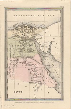
Verlag: Published for the Proprietors by Mr. Bull. (1833)., London., 1833
Anbieter: Asia Bookroom ANZAAB/ILAB, Canberra, ACT, AustralienAsia Bookroom ANZAAB/ILAB
Verkäufer/-in kontaktierenVerkäufer/-in mit 5 SternenZustand: Gebraucht
EUR 46,96
EUR 18,67 VersandVersand von Australien nach USAAnzahl: 1 verfügbar
Engraved map, 14.1 x 8.8 cm, original hand colour in very good condition. Fine miniature map with appealing hand colour denoting Lower, Central and Upper Egypt.

Verlag: London. Published for the Proprietors Mr. Bull, Holles St., 1830, 1830
Anbieter: J. Patrick McGahern Books Inc. (ABAC), Ottawa, ON, KanadaJ. Patrick McGahern Books Inc. (ABAC)
Verkäufer/-in kontaktierenVerkäufer/-in mit 4 SternenZustand: Gebraucht - Sehr gut
EUR 63,95
EUR 8,78 VersandVersand von Kanada nach USAAnzahl: 1 verfügbar
No Binding. Zustand: Fine. 16x 10cm (6.25"x 4"), (image, 9x 14cm), attractively hand coloured, fine - Bonar Law #311. p224. - One of 40 maps from the "Geographical Annual" designed and engraved by London engraver, Thomas Starling. A nice example of miniature cartography.


