Map neele samuel john (3 Ergebnisse)
Verlag: (W. and D. Brownlie) [1805]., London & Glasgow., 1805
Anbieter: Asia Bookroom ANZAAB/ILAB, Canberra, ACT, AustralienAsia Bookroom ANZAAB/ILAB
Verkäufer/-in kontaktierenVerkäufer/-in mit 5 SternenZustand: Gebraucht
EUR 141,15
EUR 18,61 VersandVersand von Australien nach USAAnzahl: 1 verfügbar
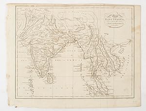
Engraved map, 18.7 x 23.9 cm, original folds, age toned and spotted, inner margin a trifle ragged, paper thinning in a few spots, in good condition. Attractive map engraved for "A System of Geography; or A Descriptive, Historical, and Philosophical View of the Several Quarters of the World" published in 1805.
Verlag: circa1803., (London)., 1803
Anbieter: Asia Bookroom ANZAAB/ILAB, Canberra, ACT, AustralienAsia Bookroom ANZAAB/ILAB
Verkäufer/-in kontaktierenVerkäufer/-in mit 5 SternenZustand: Gebraucht
EUR 156,83
EUR 18,61 VersandVersand von Australien nach USAAnzahl: 1 verfügbar
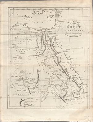
Engraved map, 23 x 18.5 cm, original folds, small split to one fold affecting the margin only, paper age- toned, lower corner darkened, and, on the verso inked circles to the lower half in an early hand, but in good condition. Finely engraved early 19th Century map also showing, to the north, Syria, Palestine and Cyprus and Darf…ur and Mountains of the Moon, Sources of the Nile to the South.
Verlag: Thomson., London., 1816
Anbieter: Asia Bookroom ANZAAB/ILAB, Canberra, ACT, AustralienAsia Bookroom ANZAAB/ILAB
Verkäufer/-in kontaktierenVerkäufer/-in mit 5 SternenZustand: Gebraucht
EUR 266,62
EUR 18,61 VersandVersand von Australien nach USAAnzahl: 1 verfügbar
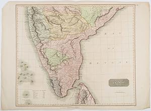
Engraved map with full handcolour, 50.5 x 59.7 cms ; 53.9 x 73.8 cms (sheet), central fold, a few minor edge tears one intruding into the top border (the map unscathed), marginal edgewear, two corners with some loss , but the map in very good crisp condition. An elegant map with great detail, prepared for John Thomson's influent…ial "New General Atlas" (1814-1821). Showing India from 20 degrees to 7 degrees north of the equator and includes the northern half of Ceylon, with territorial interests attractively coloured.


