Gesamtpreis (1 Artikel Artikel):
Versandziel:

map chart (137 Ergebnisse)
Direkt zu den wichtigsten Suchergebnissen
Suchfilter
Produktart
- Alle Product Types
- Bücher (17)
- Magazine & Zeitschriften (Keine weiteren Ergebnisse entsprechen dieser Verfeinerung)
- Comics (Keine weiteren Ergebnisse entsprechen dieser Verfeinerung)
- Noten (Keine weiteren Ergebnisse entsprechen dieser Verfeinerung)
- Kunst, Grafik & Poster (Keine weiteren Ergebnisse entsprechen dieser Verfeinerung)
- Fotografien (Keine weiteren Ergebnisse entsprechen dieser Verfeinerung)
- Karten (120)
- Manuskripte & Papierantiquitäten (Keine weiteren Ergebnisse entsprechen dieser Verfeinerung)
Zustand Mehr dazu
- Neu (Keine weiteren Ergebnisse entsprechen dieser Verfeinerung)
- Wie Neu, Sehr Gut oder Gut Bis Sehr Gut (2)
- Gut oder Befriedigend (4)
- Ausreichend oder Schlecht (Keine weiteren Ergebnisse entsprechen dieser Verfeinerung)
- Wie beschrieben (131)
Einband
Weitere Eigenschaften
- Erstausgabe (14)
- Signiert (3)
- Schutzumschlag (Keine weiteren Ergebnisse entsprechen dieser Verfeinerung)
- Angebotsfoto (129)
Sprache (3)
Gratisversand
Land des Verkäufers
Verkäuferbewertung
-

ECOLOGY OF THE BIRDS OF QUAKER RUN VALLEY, ALLEGANY STATE PARK, NEW YORK
Verlag: The University of the State of New York, 1936
Anbieter: Dick's Book Barn, Trumansburg, NY, USA
Verkäuferbewertung 3 von 5 Sternen

Soft cover. Zustand: Very Good. No Jacket. B&W photos and fold-out Chart and map (illustrator). New York State Museum Handbook 16 This copy is in excellent condition; tight and clean; the wraps show no wear.
-

Structure Of The Northern Muddy Mountain Area, Nevada
Sprache: Englisch
Verlag: Geological Society Of America, 1949
Anbieter: Arroyo Seco Books, Pasadena, Member IOBA, Pasadena, CA, USA
Verbandsmitglied: IOBA
Verkäuferbewertung 4 von 5 Sternen

Erstausgabe Signiert
Soft cover. Zustand: Near Fine. Photographs, Chart, Folding Map (illustrator). 1st Edition. 923-968 Pp. Brown Printed Wrappers.Near Fine. Generically Inscribed By Author. Per Wikipedia, Chester Ray Longwell (1887 - 1975) Was An American Geologist Who Conducted Extensive Research Into The Geology Of The Basin And Range Province In Nevada. His Fieldwork Led To A More Complete Understanding Of Paleozoic And Lower Mesozoic Stratigraphic Sequence In The Southern Great Basin. Elected A Fellow Of The Geological Society Of America In 1923, Longwell Served As Society's President In 1949. He Was Elected A Member Of The National Academy Of Sciences In 1935. From 1953 To 1954, He Served As President, American Geological Institute. He Was Elected To The American Philosophical Society In 1948 And The American Academy Of Arts And Sciences In 1953. Inscribed by Author(s).
-
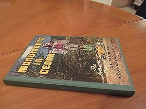
Monuments In Cedar (1St Edition, 1945, Signed By Author, With Bookmark)
Sprache: Englisch
Verlag: Roy Anderson, Ketchikan Ak, 1945
Anbieter: Arroyo Seco Books, Pasadena, Member IOBA, Pasadena, CA, USA
Verbandsmitglied: IOBA
Verkäuferbewertung 4 von 5 Sternen
Erstausgabe Signiert
Hardcover. Zustand: Near Fine. Folding Map And Chart Of Tlingit-Speaking People (illustrator). 1st Edition. 160 Pp. Green Cloth With Paste-On Illustration, Map And Folding Chart Of Tlingit People Tipped On To Rear Pastedown, As Issued. With The Printed Bookmark Made For This Book. First Printing, 1945. Signed By Author On Front Pastedown. Near Fine. Signed by Author(s).
-

Mineral Resources of the Scotchman Peak Wilderness Study Area, Lincoln and Sanders Counties, Montana, and Bonner County, Idaho
Verlag: U. S. Government Printing Office, Washington, D. C., 1981
Erstausgabe
Softcover. Zustand: Very Good. First Edition. Unmarked. Two plates folded in rear pocket. ; Book Description; Spine has staples. Pages are clean and not marred by notes or folds. Covers are square with wear as noted. Ships Safe and Fast. ; U. S. Geological Survey Bulletin; Vol. 1467; B&W Illustrations; 8vo 8" - 9" tall; 26 pages DV3.
-
CHART OF THE RED SEA - an Original Antique Map
Sprache: Englisch
Erscheinungsdatum: 1809
Anbieter: K Books Ltd ABA ILAB, York, YORKS, Vereinigtes Königreich
Verbandsmitglied: ABA ILAB PBFA
Verkäuferbewertung 5 von 5 Sternen

EUR 53,56
EUR 22,53 Versand
Versand von Vereinigtes Königreich nach USAAnzahl: 1 verfügbar
In den WarenkorbNo Binding. Zustand: Very Good. A splendid map. . In very good condition. Printed circa 1809. Chart of the Red Sea, showing Abyssinia from the Straits of Babel, Mandeb to Salaka, from observations taken from the Honourable Company's Cruiser Panther.
-
A Beginner's Chinese-English Dictionary of the National Language (Gwoyeu)
Verlag: Lund Humphries, 1947
Anbieter: Daisyroots Books, GRANGE OVER SANDS, CMA, Vereinigtes Königreich
Verkäuferbewertung 5 von 5 Sternen
EUR 59,51
EUR 34,67 Versand
Versand von Vereinigtes Königreich nach USAAnzahl: 1 verfügbar
In den WarenkorbZustand: Good. Lund Humphries 1947 hardback, maroon cloth boards, colour map on back end papers, radical chart on front end paper Boards have a slight bloom on them which doesn't affect them Internally clean and sound . Comprehensive work with lots of additional charts and tables internet room C1/5.
-

First Edition. Worn folding map in the original stiff-card wrappers, edges very slightly dust-dulled and toned. Wear and tear as with age. Remains well preserved overall; bright and clean. Physical description; 1 folding map. Subjects; Wiltshire. Map of Wiltshire. English Maps. 19th century maps. 3 Kg.
-
The Ghasi (A Scheduled Caste Community of Orissa)
Verlag: Tribal/Harijan Research Inst (1994), Bhubaneswar, 1994
Anbieter: Expatriate Bookshop of Denmark, Svendborg, Dänemark
Verkäuferbewertung 5 von 5 Sternen
orig. wrappers. Folding map, folding chart (illustrator). (4),68 pages., 21x14cm, Ethnographic study of a "denotified/ ex-criminal/ vulnerable community" of Orissa. Contents: Introduction; Demographic Composition; Habitat & Settlement; Economic Life; Social Organisation; Life-Cycle Rituals; Caste Council; Religious Life; Strategy for Development. Printer's colophon at bottom of last page reads: "OGP - MP - PTS (TW) 11 - 500 - 6.1-1994" [ie: published in an edition of 500 copies]. Rear cover stained, minor rubbing, VG.
-

La Equinococosis en Espana
Verlag: Consejo Superior., Madrid, 1944
Anbieter: Expatriate Bookshop of Denmark, Svendborg, Dänemark
Verkäuferbewertung 5 von 5 Sternen
orig. wrappers. Folding chart & map, (illustrator). 24x17cm, 314,(1) pages., "Echinococcus granulosus [hydatid tapeworm] in Spain" Includes textual tables & photos, a photoplate, folding chart & folding map. Contents: Nomenclatura de la afeccion; Datos naturalistas sobre la equinococosis; Unicismo o pluralismo de la tenia causante de la equinococosis; Fase larvaria de los ciclofilididos y en especial de los equinococos; Equinococosis en general; Equinococosis granulosa humana; Equinococosis segun su topografia; Equinococosis neuroaxiales; Equinococosis alveolar; Reflexiones sobre la casuistica hispana de la equinococosis humana; Bibliografia equinococosica hispana. The bibliography on tapeworm in Spain runs 48 pages and describes & annotates 446 items, mostly 19th-20th Century. Unopened. Rubbed,wrappers soiled, a 2cm rear hinge tear, Good.
-
Surat and its Trade in the Second Half of the Seventeenth Century
Verlag: University of Delhi, Delhi, 1977
Anbieter: Expatriate Bookshop of Denmark, Svendborg, Dänemark
Verkäuferbewertung 5 von 5 Sternen
orig. cloth. Zustand: some rubbing,Good +. 2 photoplates,1 map,1 chart (illustrator). 22x14cm, viii,223 pp, Includes 2 photoplates, 1 map-plate,1 chart-plate.
-
Holsteens Erobring og Omvendelse til Kristendom af Keiser Carl den Store : Et kronet Priis-Skrivt
Verlag: Forfatterens Forlag, Kjřbenhavn, 1826
Anbieter: Expatriate Bookshop of Denmark, Svendborg, Dänemark
Verkäuferbewertung 5 von 5 Sternen
Later boards. Folding map & chart. (illustrator). 20x12cm, 184 pp., Recent binder's blind boards. Includes a large folding map & a large folding chart. Text entirely in Danish: "Holstein's Conquest & Conversion to Christianity by Charlemagne". Some foxing. All edges gilt. VG.
-
Israndens tilbagerykning fra Řstjylland til Sjaelland-Fyn, belyst ved Ledeblokke
Verlag: C.A. Reitzels Forlag, Křbenhavn, 1932
Anbieter: Expatriate Bookshop of Denmark, Svendborg, Dänemark
Verkäuferbewertung 5 von 5 Sternen
orig.wrappers. Folding map & chart. (illustrator). 23x15cm, 70 pp., Series: Danmarks Geologiske Undersřgelse, IV. Rćkke, Bd. 2, Nr. 9. Danish text. Includes an 11-page German summary: "Der Ruckzüg des Eisrandes von Ostjütland nach Seeland-Funen durch Leitheschiebe beleuchtet". Minor rubbing. Corner bump. VG.
-
Die Herren von Wallbrunn zu Ernsthofen : Geschichte einer Herrschaft : 1440-1722
Verlag: Verein für Heimatsgeschichte, Ober-Ramstadt, 1977
Anbieter: Expatriate Bookshop of Denmark, Svendborg, Dänemark
Verkäuferbewertung 5 von 5 Sternen
orig.wrappers. Zustand: Minor rubbing. VG. Folding map & chart. (illustrator). 24x15cm, 160 pp.
-
The Religion of Bellona Island: A Study of the Place of Beliefs & Rites in the Social Life of Pre-Christian Bellona: Part 1.
Verlag: National Museum of Denmark, Copenhagen, 1966
Anbieter: Expatriate Bookshop of Denmark, Svendborg, Dänemark
Verkäuferbewertung 5 von 5 Sternen
orig.wrappers. Folding map & chart (illustrator). 25x18cm, xii, 140 pp, University of Copenhagen doctoral dissertation. Series: Language and Culture of Rennell and Bellona Island Full title reads: "The Religion of Bellona Island: A Study of the Place of Beliefs & Rites in the Social Life of Pre-Christian Bellona: Part 1: The Concepts of Supernaturals". Contents: Introduction: Field Work & Sources; The Purpose of the Present Study; Methods; Limitations of the Present Study; Positive Factors; Negative Factors; General Evaluation of the Material; Present-day Attitudes; Informants; Bellona Society: An Outline: Geography & Economy; Clans, Subclans & Lineages; The Household; Marriage; Parents & Children; Siblings & Cousins; Mother's Brother & Man's Sister's Child; Affinal Kinsmen; Social Stratifications & the Political System; The Universe: Creation of the World; The Universe; The Gods in General: Types &Physiognomies of the Gods; Relationship of Gods to Flora & Fauna; Worshipped & Non-worshipped Gods; Duality of the Worshipped Gods; The Sky Gods ('atua ngangi); The Gods in Ngabenga; Tehainga'atua; Other Sky Gods; The District Gods ( ngasuenga); 'Aitu and ngasuenga; Tehu'aingabenga; Other District Gods; The Significance of District Gods; Non-worshipped Gods ('apai); The Culture Heroes (kakai); The Hiti; The Ancestors: Death & Afterlife; Annihilated Ancestors; Worshipped Ancestors; Man & Supernaturals: The Supernaturals: An Outline; Relations to Nature; Social Relations; Ancestors; Origins & Explanations; Transactions; Appendix: The Sacred & the Profane: A Survey of Some Bellonese Concepts. Some rubbing & soil to wrappers, VG.
-

The Port of Callao, in the South Sea.
Erscheinungsdatum: 1753
Anbieter: Geographicus Rare Antique Maps, Brooklyn, NY, USA
Verbandsmitglied: ABAA ESA ILAB
Verkäuferbewertung 3 von 5 Sternen
Karte
Very good. Fold lines visible. Size 9 x 15 Inches. This is a rare work by the British cartographer Thomas Jefferys, a 1753 map of Callao and Lima in Peru. It depicts the coastline of the Lima region while also serving as a nautical chart, noting soundings, islets, and other features. A Closer Look This overhead view of the coast is oriented towards the east, covering an area of about 30 miles, from Ancon in the north to Chorrillos in the south. Waterways, agricultural and urban areas, and elevation are indicated. Scales are given in toises and Spanish fathoms. The motivation for the map's production is not immediately clear, but Jefferys' connections with the Crown and the map's dedication to 'His Catholic Majesty' would suggest it was considered important information for the Court, especially given the regular warfare between Britain and Spain across the 18th century. Although produced during a period of peace, the British and Spanish had recently negotiated an end to the War of Jenkins' Ear (1739 - 1748), which was fought in the Americas but became subsumed under the wider War of Austrian Succession (1740 - 1748). Afterwards, the two empires avoided direct confrontations but generally fell into opposing camps, as during the Seven Years' War (1756 - 1763) and the American Revolutionary War (1775 - 1783). Lima and Callao Lima was founded in 1537 as a power base for Francisco Pizarro in his fight against both indigenous forces and Spanish rivals. The city was built somewhat inland to protect from seaborne attack, and Callao developed as the port to Lima. Lima was the capital of the Viceroyalty of Peru from 1543 onwards. The city walls were built between 1684 and 1687, to guard against attack from pirates who roamed the Pacific Ocean. Callao was founded two years after Lima, about 15 km to the west, and grew into a major port, not just for Lima but for all of Spanish South America. Any goods bound for export coming from the southern half of Spanish South America went through Callao, even if originating east of the Andes in what is now Argentina. Thereafter, they were sent to Panama and carried overland to Caribbean ports or travelled west across the Pacific as part of the Manila Galleon Trade. In 1746, a powerful earthquake followed by a tsunami completely destroyed Callao and badly damaged Lima. Afterwards, Callao had to be entirely rebuilt, including fortifications at the end of the promontory on which Callao sits, which are faintly visible here. The resulting structure, the Fortaleza del Real Felipe, was built between 1747 and 1774 and was thus under construction when this map was made. The importance of defending Lima and the risk of seaborne pirate attack meant that the project received considerable resources and became one of the most important structures in the Spanish New World colonies. Its value was proven a century later, ironically against the Spanish, when the former imperial master launched a failed attempt to recapture independent Peru in 1866. Publication History and Census This map was made by Thomas Jefferys, known as the 'Geographer to the Prince of Wales' and later as 'Geographer to the King.' It is undated but appeared in 1753 in the important publication The Gentleman's Magazine . It is only independently cataloged in the holdings of a small handful of institutions, though is likely to be distributed in institutions holding copies of The Gentleman's Magazine from 1753. References: OCLC 45130851.
-

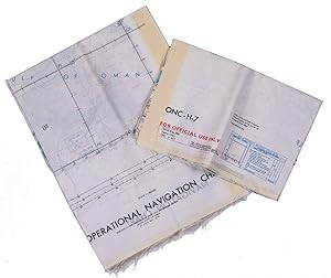
Persian Gulf | ONC-H-6/7. Operational navigation chart.
Verlag: Aeronautical chart and information center, United States Air Force,, St Louis,, 1967
Anbieter: Antiquariaat FORUM BV, Houten, Niederlande
Verkäuferbewertung 5 von 5 Sternen
EUR 1.500,00
EUR 25,00 Versand
Versand von Niederlande nach USAAnzahl: 1 verfügbar
In den WarenkorbRayon pilot's map of the Arabian Gulf region focusing on the Trucial States (modern UAE), Qatar, Bahrain, Oman, Iran and Saudi Arabia, including main oil installations. Items of specific interest to aircraft, such as airfields and even seaplane bases, are particularly listed. Warnings to stay within the specific flying routes while in Iran are placed on multiple locations. While the map depicts a continuous area on both side on of one sheets, it actually consist of two maps, originally published separately. Slightly frayed at the edges. In very good condition. Two maps colour printed on both sides of a sheet of silk (103 x 78.5 cm) on a scale of ca. 1:1,000,000. The two maps (ONC-H-6 & ONC-H-7) show one continuous area.
-

World aeronautical chart (446) Wadi Sirhan.
Verlag: USAF aeronautical chart and information service,, Washington, DC,, 1958
Anbieter: Antiquariaat FORUM BV, Houten, Niederlande
Verkäuferbewertung 5 von 5 Sternen
Pilot's map of Wadi Sirhan in the border region of Iraq, Saudi Arabia and Jordan. The map shows the concave and zigzagging border between Saudi Arabia and Jordan before it revision in 1965. The indefinite nature of the borders is clearly visible on the map in the changed and crossed-out borderlines and the notations "boundary approximate" and "boundary approximate". Several areas are marked as "danger area" or "prohibited area". Stamped "obsolete for use in aviation", otherwise in excellent condition. Colour printed map, 56 x 73.5 cm, with a legend printed on the back. Scale 1:1,000,000.
-
Persian Gulf | ONC-H-6/7. Operational navigation chart.
Verlag: Aeronautical chart and information center, United States Air Force,, St Louis,, 1969
Anbieter: Antiquariaat FORUM BV, Houten, Niederlande
Verkäuferbewertung 5 von 5 Sternen
EUR 2.800,00
EUR 25,00 Versand
Versand von Niederlande nach USAAnzahl: 1 verfügbar
In den WarenkorbRayon pilot's map of the Arabian Gulf region focusing on the Trucial States (modern UAE), Qatar, Bahrain, Oman, Iran and Saudi Arabia, including main oil installations. Items of specific interest to aircraft, such as airfields and even seaplane bases, are particularly listed. Warnings to stay within the specific flying routes while in Iran are placed on multiple locations. While the map depicts a continuous area on both side on of one sheets, it actually consist of two maps, originally published separately. We here include two copies so the whole area can be displayed. The maps are reproduced after the third and fourth edition.In very good condition. Two copies of two folding maps colour printed on both sides of a sheet of silk (103 x 78.5 cm) on a scale of ca. 1:1,000,000. The two maps (ONC-H-6 & ONC-H-7) show one continuous area.
-

Preliminary Coast Chart No. 8 Seguin Island to Kennebunkport, Maine.
Erscheinungsdatum: 1859
Anbieter: Geographicus Rare Antique Maps, Brooklyn, NY, USA
Verbandsmitglied: ABAA ESA ILAB
Verkäuferbewertung 3 von 5 Sternen
Karte
Very good. Backed on archival tissue for stability. Exhibits light wear along original fold lines. Some spotting and foxing evident. Exhibits a small area of infill. Blank on verso. Size 38.75 x 22.75 Inches. This is an 1859 U.S. Coast Survey nautical chart or map of the southern coast of Maine. Depicting portions of coastal Maine from the mouth of the Kennebec River and Seguin Island to Goat Island and Kennebunkport (although Kennebunkport is unlabeled), innumerable depth soundings are recorded here in aid of navigation. Coastal islands abound and are nearly all identified, along with many lighthouses, such as the Goat Island Light, the Wood Island Light, the Cape Elizabeth Light, the Seguin Island Light, the Pond Island Light, and the Breakwater Light near Portland. Coves, points, and bays along the coastline are also identified. Tables detailing the region's lighthouses, tides, and magnetic variations are included along the right border, along with notes concerning the depth soundings and abbreviations employed on the map. Publication History and Census The creation of this chart, as was the case with all U.S. Coast Survey charts, was a collaboration. C. O. Boutelle and T. J. Cram undertook triangulation work, while the topography was executed by A. W. Longfellow and I. Hull Adams. The hydrography was executed by parties under the command of M. Woodhull, S.D. Trenchard, and W.G. Temple. The whole work was compiled and produced under the supervision of A. D. Bache, one of the most influential Superintendents in the history of the U.S. Coast Survey. An example is cataloged in OCLC and is part of the institutional collection at the University of Maine. References: OCLC 180672031.
-

Cachimbo Range Brazil.
Erscheinungsdatum: 1955
Anbieter: Geographicus Rare Antique Maps, Brooklyn, NY, USA
Verbandsmitglied: ABAA ESA ILAB
Verkäuferbewertung 3 von 5 Sternen
Karte
Very good. Minor wear and toning along original fold lines. Minor spotting. Size 22 x 29 Inches. This is a scarce 1955 U.S. Air Force aeronautical chart or map of the Cachimbo Range, Brazil. It covers parts of the Brazilian states of Para and Mato Grosso from Ilha Guandu south to Pouso Alegre and east as far as Aldeias dos Tapirapes. The map is highly detailed and notes several rivers, towns, lakes, villages and other hydrographical and topographical features essential for the air pilot. Verso of this chart features legends and a World aeronautical chart index. This chart was published by the USAF Aeronautical Chart and Information Service and was issued as chart no. 1069. First issued in 1943, this is the second edition revised to Feb 1955.
-

Cape Comorin India-Mahe.
Erscheinungsdatum: 1954
Anbieter: Geographicus Rare Antique Maps, Brooklyn, NY, USA
Verbandsmitglied: ABAA ESA ILAB
Verkäuferbewertung 4 von 5 Sternen
Karte
Very good. Minor wear and toning along original fold lines. Minor spotting. Size 22 x 29 Inches. This is a scarce 1954 U.S. Air Force aeronautical chart or map of the south India. It covers from Thiruvannamalai south to Kanyakumari. Important cities of Madurai, Coimbatore, Cochin, Thiruvananthapuram (Trivandrum), Tiruchirappalli, Madurai, etc. are noted throughout. The map is highly detailed and noted towns, cities, rivers, lakes, capes, bays, roads, railways, and other hydrographical and topographical features essential for the air pilot. Verso of this chart features legends and a world aeronautical chart index. This chart was published by the USAF Aeronautical Chart and Information Service, Washington 25, D.C., and was issued as chart no. 795. First issued in 1947, this is the seventh edition revised to May 1954.
-

Cape Sao Roque Brazil.
Erscheinungsdatum: 1956
Anbieter: Geographicus Rare Antique Maps, Brooklyn, NY, USA
Verbandsmitglied: ABAA ESA ILAB
Verkäuferbewertung 4 von 5 Sternen
Karte
Very good. Minor wear and toning along original fold lines. Minor spotting. Size 22 x 29 Inches. This is a scarce 1956 U.S. Air Force aeronautical chart or map of the northeast coast of Brazil. It focuses on Cape Sao Roque, on the northeastern tip of Brazil, and its vicinity from Recife north as far as Fortaleza and inland as far as Juazeiro do Norte. The cities of Joao Pessoa, Natal, Mossoro, Campina Grande, etc. are noted. The map is highly detailed and notes several rivers, towns, lakes, villages and other hydrographical and topographical features essential for the air pilot. Verso of this chart features legends and a world aeronautical chart index. This chart was published by the USAF Aeronautical Chart and Information Service, and was issued as chart no. 1018. First issued in 1947, this is the fifth edition revised to April 1956.
-

Carisis Novos Range Brazil.
Erscheinungsdatum: 1952
Anbieter: Geographicus Rare Antique Maps, Brooklyn, NY, USA
Verbandsmitglied: ABAA ESA ILAB
Verkäuferbewertung 4 von 5 Sternen
Karte
Very good. Minor wear and toning along original fold lines. Minor spotting. Size 22 x 29 Inches. This is a fine 1952 U.S. Air Force aeronautical chart or map of the Cariris Novos mountain range along the boundaries of the States of Ceara and Piaui, Brazil. It covers the range and its vicinity from Piripiri south to Simplicio Mendes and from Saboeiro westward as far as Anaja. The cities of Teresina, Picos, Floriano, etc. are noted. The map is highly detailed and notes several rivers, towns, lakes, villages and other hydrographical and topographical features essential for the air pilot. Verso of this chart features legends and a world aeronautical chart index. This chart was published by the USAF Aeronautical Chart and Information Service, and was issued as chart no. 1017. First issued in 1949, this is the second edition revised to April 1952.
-

Cape El Cheil British Somaliland-Ethiopia-Italian Somaliland.
Erscheinungsdatum: 1955
Anbieter: Geographicus Rare Antique Maps, Brooklyn, NY, USA
Verbandsmitglied: ABAA ESA ILAB
Verkäuferbewertung 3 von 5 Sternen
Karte
Very good. Minor wear and toning along original fold lines. Minor spotting. Size 22 x 29 Inches. This is a scarce 1955 U.S. Air Force aeronautical chart or map of southeastern Somalia. It covers from El Uarot north past Obbia or Hobya port city to Negro Bay and inland as far as Galadi. The chart notes towns, roads, cities, rivers, topography and other data essential to the air pilot. Verso features legends and a world aeronautical chart index. This chart was published by the Aeronautical Chart Service, Washington 25 D.C., and issued as chart no. 808. First issued in 1947, this is the second edition revised to Jan 1955.
-

Coupes Geologiques.
Erscheinungsdatum: 1837
Anbieter: Geographicus Rare Antique Maps, Brooklyn, NY, USA
Verbandsmitglied: ABAA ESA ILAB
Verkäuferbewertung 3 von 5 Sternen
Karte
Very good. Original centerfold. Blank on verso. Size 13.5 x 18 Inches. This is a fine example of Conrad Malte-Brun's 1837 chart showing geological sections. It features cross-sections between Paris and Colmar, between the Ardennes and the Limousin, in the Pyrenees, between Cumberland and Durham (england), and in Derbyshire. A legend is included below each cross-section. This chart was issued as plate no. 20 in Conrad Malte-Brun's 1837 Atlas Complet du Precis de la Geographie Universelle . References: Rumsey 0458.026. Phillips (Atlases) 6079.
-

Great Nicobar Island Nicobar Islands.
Erscheinungsdatum: 1954
Anbieter: Geographicus Rare Antique Maps, Brooklyn, NY, USA
Verbandsmitglied: ABAA ESA ILAB
Verkäuferbewertung 3 von 5 Sternen
Karte
Very good. Minor wear and toning along original fold lines. Minor spotting. Size 22 x 29 Inches. This is a fine 1954 U.S. Air Force aeronautical chart or map of the Great Nicobar Island and vicinity, part of the Nicobar Islands of India located in the Indian Ocean. It covers the Camorta Island, Nancowry Island, Katchall Island, Little Nicobar Island and the Great Nicobar Island. Important cities, rivers and roads are noted along with other hydrographical and topographical features essential for the air pilot. Verso of this chart features legends and a world aeronautical chart index. This chart was published by the USAF Aeronautical Chart and Information Center, and was issued as chart no. 801. First issued in 1949, this is the third edition revised to July 1954.
-

Kaouar Oasis French Equatorial Africa-French West Africa.
Erscheinungsdatum: 1954
Anbieter: Geographicus Rare Antique Maps, Brooklyn, NY, USA
Verbandsmitglied: ABAA ESA ILAB
Verkäuferbewertung 3 von 5 Sternen
Karte
Very good. Minor wear and toning along original fold lines. Minor spotting in red. Size 22 x 29 Inches. This is a fine 1954 U.S. Air Force aeronautical chart or map of the Kaouar Oasis in north east Niger. The map covers the region from Kaussa Arma north to Gouonega in Chad. The towns of Bilma, and Dirkou are noted. The map is highly detailed, noting communes, valleys, mountains, deserts, rivers, dunes, cities and other hydrographical and topographical features essential for the air pilot. Famous for the production of salt and dates, were part of the Bornu Empire and the Fezzan caravan route. Though mostly desert, 19th century Fezzan had numerous oases and supported a relatively large population. This desert kingdom was a critical stopping point for trade caravans crossing the Sahara since antiquity. Verso of this chart features legends and a world aeronautical chart index. This chart was published by the USAF Aeronautical Chart and Information Center and was issued as chart no. 663. First issued in 1948, this is the third edition revised to May 1954.
-

Lake Sap Cambodia-Laos-Thailand-Vietnam.
Erscheinungsdatum: 1955
Anbieter: Geographicus Rare Antique Maps, Brooklyn, NY, USA
Verbandsmitglied: ABAA ESA ILAB
Verkäuferbewertung 3 von 5 Sternen
Karte
Very good. Minor wear along original fold lines. Minor spotting. Toning along fold lines and lower right quadrant. Size 22 x 29 Inches. This is a fine 1955 U.S. Air Force aeronautical chart of Lake Sap (Tonle Sap) and vicinity in Cambodia. It covers from the Gulf of Siam and Chanthaburi north to Chaiyaphum in Thailand and from Buon Ma Thuot north to Da Nang. Part of the Mekong River is also included. The map is highly detailed, noting important cities, towns, rivers, roads as well as other hydrographical and topographical features essential for the air pilot. The Tonle Sap or Sap Lake, is the largest fresh water lake in Southeast Asia. This unusual combined lake and river system changes directions twice a year, when it drains into the Mekong River during the dry season and backs up during the rains to form the enormous Lake Sap. Verso of this chart features legends and a world aeronautical chart index. This chart was published by the USAF Aeronautical Chart and Information Center, and was issued as chart no. 738. First issued in 1948, this is the seventh edition revised to March 1955.
-

Little Andaman Island Andaman and Nicobar Islands.
Erscheinungsdatum: 1957
Anbieter: Geographicus Rare Antique Maps, Brooklyn, NY, USA
Verbandsmitglied: ABAA ESA ILAB
Verkäuferbewertung 3 von 5 Sternen
Karte
Very good. Minor wear and toning along original fold lines. Minor spotting. Size 22 x 29 Inches. This is a fine 1957 U.S. Air Force aeronautical chart or map of the Little Andaman Island and vicinity, part of the Andaman and Nicobar Islands of India located in the Indian Ocean. It covers the South Andaman Island, North Sentinel Island, Rutland Island, Havelock Island, Neill Island, Little Andaman Island, Car Nicobar Island, Camorta Island, Teressa Island, Trinkat Island and the Tillanchong Island. Important cities, rivers and roads are noted along with other hydrographical and topographical features essential for the air pilot. Verso of this chart features legends and a world aeronautical chart index. This chart was published by the USAF Aeronautical Chart and Information Center, and was issued as chart no. 798. First issued in 1948, this is the fifth edition revised to Oct 1957.
-

Giuba River Ethiopia-Italian Somaliland.
Erscheinungsdatum: 1954
Anbieter: Geographicus Rare Antique Maps, Brooklyn, NY, USA
Verbandsmitglied: ABAA ESA ILAB
Verkäuferbewertung 4 von 5 Sternen
Karte
Very good. Minor wear and toning along original fold lines. Minor spotting. Size 22 x 29 Inches. This is a scarce 1954 U.S. Air Force aeronautical chart or map of southern Somalia. It covers from Margherita north past Mogadishu to El Dere and inland as far as Afmadow. The chart notes towns, roads, cities, rivers, topography and other data essential to the air pilot. Verso features legends and a world aeronautical chart index. This chart was published by the Aeronautical Chart Service, and issued as chart no. 911. First issued in 1947, this is the fifth edition revised to Mar 1954.