
Gesamtpreis (1 Artikel Artikel):
Versandziel:

map artist (10 Ergebnisse)
Direkt zu den wichtigsten Suchergebnissen
Suchfilter
Produktart
- Alle Product Types
- Bücher (10)
- Magazine & Zeitschriften (Keine weiteren Ergebnisse entsprechen dieser Verfeinerung)
- Comics (Keine weiteren Ergebnisse entsprechen dieser Verfeinerung)
- Noten (Keine weiteren Ergebnisse entsprechen dieser Verfeinerung)
- Kunst, Grafik & Poster (Keine weiteren Ergebnisse entsprechen dieser Verfeinerung)
- Fotografien (Keine weiteren Ergebnisse entsprechen dieser Verfeinerung)
- Karten (Keine weiteren Ergebnisse entsprechen dieser Verfeinerung)
- Manuskripte & Papierantiquitäten (Keine weiteren Ergebnisse entsprechen dieser Verfeinerung)
Zustand Mehr dazu
- Neu (1)
- Wie Neu, Sehr Gut oder Gut Bis Sehr Gut (1)
- Gut oder Befriedigend (5)
- Ausreichend oder Schlecht (Keine weiteren Ergebnisse entsprechen dieser Verfeinerung)
- Wie beschrieben (3)
Einband
Weitere Eigenschaften
- Erstausgabe (Keine weiteren Ergebnisse entsprechen dieser Verfeinerung)
- Signiert (Keine weiteren Ergebnisse entsprechen dieser Verfeinerung)
- Schutzumschlag (Keine weiteren Ergebnisse entsprechen dieser Verfeinerung)
- Angebotsfoto (4)
Sprache (2)
Gratisversand
- Kostenloser Versand nach USA (Keine weiteren Ergebnisse entsprechen dieser Verfeinerung)
Land des Verkäufers
Verkäuferbewertung
-

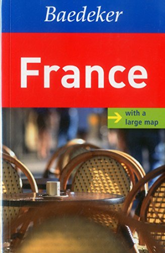
Algarve Baedeker Guide (Baedeker Guides)
Sprache: Englisch
Verlag: MAIRDUMONT GmbH & Co. KG 08/06/2012, 2012
ISBN 10: 3829768133 ISBN 13: 9783829768139
Anbieter: Bahamut Media, Reading, Vereinigtes Königreich
Verkäuferbewertung 5 von 5 Sternen

EUR 3,17
EUR 8,10 Versand
Versand von Vereinigtes Königreich nach USAAnzahl: 2 verfügbar
In den WarenkorbZustand: Very Good. Shipped within 24 hours from our UK warehouse. Clean, undamaged book with no damage to pages and minimal wear to the cover. Spine still tight, in very good condition. Remember if you are not happy, you are covered by our 100% money back guarantee.
-
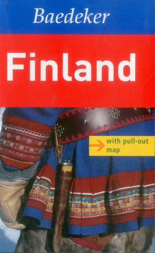
Finland Baedeker Guide (Baedeker Guides)
Sprache: Englisch
Verlag: Marco Polo Travel Publishing, Ltd., 2012
ISBN 10: 3829768141 ISBN 13: 9783829768146
Anbieter: WorldofBooks, Goring-By-Sea, WS, Vereinigtes Königreich
Verkäuferbewertung 5 von 5 Sternen
EUR 8,39
EUR 6,50 Versand
Versand von Vereinigtes Königreich nach USAAnzahl: 1 verfügbar
In den WarenkorbPaperback. Zustand: Very Good. The book has been read, but is in excellent condition. Pages are intact and not marred by notes or highlighting. The spine remains undamaged.
-
Algarve Baedeker Guide (Baedeker Guides)
Sprache: Englisch
Verlag: MAIRDUMONT GmbH and Co. KG, 2012
ISBN 10: 3829768133 ISBN 13: 9783829768139
Anbieter: Reuseabook, Gloucester, GLOS, Vereinigtes Königreich
Verkäuferbewertung 5 von 5 Sternen
EUR 3,75
EUR 11,61 Versand
Versand von Vereinigtes Königreich nach USAAnzahl: 1 verfügbar
In den WarenkorbPaperback. Zustand: Used; Good. Dispatched, from the UK, within 48 hours of ordering. This book is in good condition but will show signs of previous ownership. Please expect some creasing to the spine and/or minor damage to the cover.
-
Softcover. Zustand: Bon. Various Map Artist (illustrator). Edition 2012. Ammareal reverse jusqu'ŕ 15% du prix net de cet article ŕ des organisations caritatives. ENGLISH DESCRIPTION Book Condition: Used, Good. Edition 2012. Ammareal gives back up to 15% of this item's net price to charity organizations.
-

Marco Polo Guide Barcelona
Anbieter: Revaluation Books, Exeter, Vereinigtes Königreich
Verkäuferbewertung 5 von 5 Sternen
EUR 15,56
EUR 11,61 Versand
Versand von Vereinigtes Königreich nach USAAnzahl: 1 verfügbar
In den WarenkorbPaperback. Zustand: Brand New. paperback/map edition. 148 pages. 7.50x4.25x0.75 inches. In Stock.
-
Algarve Baedeker Travel Guide (Baedeker Guides)
Sprache: Englisch
Verlag: MAIRDUMONT GmbH & Co. KG, Germany, Ostfildern, 2012
ISBN 10: 3829768133 ISBN 13: 9783829768139
Anbieter: WorldofBooks, Goring-By-Sea, WS, Vereinigtes Königreich
Verkäuferbewertung 5 von 5 Sternen
EUR 25,49
EUR 6,50 Versand
Versand von Vereinigtes Königreich nach USAAnzahl: 4 verfügbar
In den WarenkorbPaperback. Zustand: Very Good. This superb full-colour, illustrated guide features 3D laminated cut-outs to show you the key sights of the Algarve in perspective and a large, fully-indexed, pull-out map. Additional detailed maps and plans can also be found throughout the guide, clearly pin-pointing the best places to stay and the top places to eat and drink. At the heart of the guide is a wealth of comprehensive information written by experts on the sights and top attractions, in an easy-to-read A-Z format. Also included are great, practical travel tips covering accommodation and food and drink for all budgets, entertainment, sport, transport and health; not to mention some insider tips for saving money or having a unique travel experience. There is also a variety of recommended tours covering the best routes available, to ensure you get the most from your destination. The plastic wallet allows you to keep the guide and map together and ensures that both will survive in all weather. Baedeker - setting a new standard in 21st century travel guide publishing. The book has been read, but is in excellent condition. Pages are intact and not marred by notes or highlighting. The spine remains undamaged.
-
![Bild des Verkäufers für [Original lithograph/lithografie van v. Geldorp] Om een miljoen, 6 Januari 1899, 1 pp. zum Verkauf von Antiquariaat Arine van der Steur / ILAB](https://pictures.abebooks.com/inventory/md/md31290601806.jpg)
[Original lithograph/lithografie van v. Geldorp] Om een miljoen, 6 Januari 1899, 1 pp.
Anbieter: Antiquariaat Arine van der Steur / ILAB, Den Haag, Niederlande
Verkäuferbewertung 4 von 5 Sternen

Zustand: Very Good. 300 x 290 mm. Bijvoegsel van de "Amsterdamsche Courant" van 6 Januari 1899. Pictured are Minister Lely (Minister van Waterstaat, Handel en Nijverheid) and the 'Stedemaagd'. Lithograph, total: 300 x 290; on paper. Folding lines in the middle of the print.
-

Asia.
Verlag: Henry Teesdale & Co. (1836)., London., 1836
Anbieter: Asia Bookroom ANZAAB/ILAB, Canberra, ACT, Australien
Verkäuferbewertung 5 von 5 Sternen
Engraved map coloured in outline, 33.7 x 41.5 cms; 38.7 x 48 cms (sheet including platemark), relief shown by hachures, central fold, all edges gilt, in very good condition. An very attractive map prepared for Teesdale's "A New General Atlas of the World.".
-
Tokyo Bay Area - Heart of Japan's Empire.
Verlag: Chicago Daily Tribune. 28 July1945., Chicago., 1945
Anbieter: Asia Bookroom ANZAAB/ILAB, Canberra, ACT, Australien
Verkäuferbewertung 5 von 5 Sternen
Colour bird's eye view map, 22.4 x 39.3 cms on a newspaper leaf trimmed to a half sheet 29.8 x 41.6 cms (including caption), slight toning at an old central fold, the map in very good condition. Unrelated black and white photographic illustrations on the verso "Pre-flight Trainers used in Chicago to give ground instruction to would-be pilots" and "New rekindled Montauk Light, Long Island, N.Y." Map published in the Chicago Daily Tribune days before the bombing of Hiroshima on August 6,1945. "Perspective map of Tokyo bay and contiguous land and sea areas, showing Tokyo, Yokohama, the Yokosuka naval base, industrial sections and other features .In this map north is at the right instead of at the top - an expedient adopted to show all of the bay as large as possible in half page space." (caption).
-
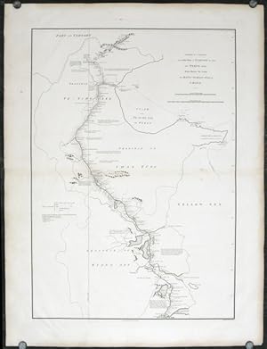
A Sketch of a Journey from Zhe-Hol in Tartary by land to Pekin and from thence by water to Hang-Tchoo-Foo in China.
Verlag: George Nicol., London., 1796
Anbieter: Asia Bookroom ANZAAB/ILAB, Canberra, ACT, Australien
Verkäuferbewertung 5 von 5 Sternen
Double-sheet engraved copperplate map, 63.2 x 44.8 cm; 75 x 57 cms (sheet including platemark), central fold, the sheet toned at the edges and central fold, a couple of minor spots and edge wear, but in very good condition. An exquisitely engraved map with fine detail of the route taken by George Macartney on the first official British embassy to China 1792-1794, undertaken with the aim of gaining trade concessions from the Chinese Emperor and published in George Staunton's officall account. While the official purpose was not successful, much was learned about China and the Chinese as is evident from this map with its explanatory texts. To the west of Pekin, just below the starting point at Zhe-hol (Jehol) which is situated at the top of this map, the commentary reads: "A great part of the country around Pekin is employed in the production of culinary vegetables and a variety of fruits." At the lower edge of the map, just north of the ending point of Hangzhou is the lake Tai Hoo: "The western side of the Tai-hoo is bounded by a very romantic and fertile country whose mountains are clutivated to their very tops. A great part of the province of Tche-tchiang appears to be cultivated with Mulberry trees for the food of the Silk worms." Cities of the 1st, 2nd and 3rd orders, "considerable towns" and villages are marked, along with "Halting places" etc. Fascinating Western documentation of the area around the Imperial Canal of the late Eighteenth Century.
