
Gesamtpreis (1 Artikel Artikel):
Versandziel:

lowry wilson (32 Ergebnisse)
Direkt zu den wichtigsten Suchergebnissen
Suchfilter
Produktart
- Alle Product Types
- Bücher (21)
- Magazine & Zeitschriften (Keine weiteren Ergebnisse entsprechen dieser Verfeinerung)
- Comics (Keine weiteren Ergebnisse entsprechen dieser Verfeinerung)
- Noten (Keine weiteren Ergebnisse entsprechen dieser Verfeinerung)
- Kunst, Grafik & Poster (6)
- Fotografien (Keine weiteren Ergebnisse entsprechen dieser Verfeinerung)
- Karten (4)
- Manuskripte & Papierantiquitäten (1)
Zustand Mehr dazu
- Neu (6)
- Wie Neu, Sehr Gut oder Gut Bis Sehr Gut (2)
- Gut oder Befriedigend (8)
- Ausreichend oder Schlecht (Keine weiteren Ergebnisse entsprechen dieser Verfeinerung)
- Wie beschrieben (16)
Einband
Weitere Eigenschaften
- Erstausgabe (4)
- Signiert (Keine weiteren Ergebnisse entsprechen dieser Verfeinerung)
- Schutzumschlag (Keine weiteren Ergebnisse entsprechen dieser Verfeinerung)
- Angebotsfoto (27)
Sprache (2)
Gratisversand
Land des Verkäufers
Verkäuferbewertung
-

Loose Leaf. Zustand: New. Reproduction. Original title: Durham Cathedral, from the Nave German: Durham Kathedrale, aus der Nave French: Cathédrale de Durham, de la Nave Spanish: Catedral de Durham, de la Nave High-quality fine-art reproduction based on an original work from the Ycba. Creation period: 19th century (1834). Professionally printed on premium fine-art paper (Photo Matt Fibre) in size A5. The motif is printed with a white border (museum-style presentation). No.
-

The Inside of a Smelting House at Broseley, Shopshire, A5
Verlag: Contentum Ltd., Larnaca, Cyprus
Kunst / Grafik / Poster
Loose Leaf. Zustand: New. Reproduction. Original title: The Inside of a Smelting House at Broseley, Shopshire German: Das Innere eines Schmelzhauses in Broseley, Shopshire French: L'intérieur d'une maison de fusion ŕ Broseley, Shopshire Spanish: El interior de una fundición en Broseley, Shopshire High-quality fine-art reproduction based on an original work from the Ycba. Creation period: 18th century (1788). Professionally printed on premium fine-art paper (Photo Matt Fibre) in size A5. The motif is printed with a white border (museum-style presentation). No.
-
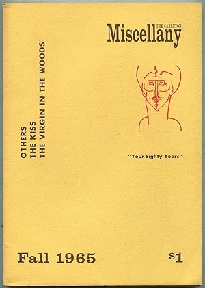
The Carleton Miscellany Fall 1965, Vol. VI, No. 4
Verlag: Carlton College, Northfield, Minnesota, 1965
Anbieter: Between the Covers-Rare Books, Inc. ABAA, Gloucester City, NJ, USA
Verbandsmitglied: ABAA ESA ILAB IOBA
Verkäuferbewertung 5 von 5 Sternen

Erstausgabe
Softcover. Zustand: Near Fine. First edition. Printed yellow wrappers. Modest age-toning, near fine. Essays and poetry contributions by John Lucas, Robley Wilson, Jr., Lawrence P. Spingarn, Ernest Kroll, John Pauker and Ralph S. Pomeroy, Harold Bordwell, Laurence Lieberman, Barry Spacks, Daniel Hoffman and Mona Van Duyn, Robert Lowry, Larry Rubin, Constance Urdang, Andrew Oerke and Kenneth Pitchford, Forbes Hays, David Porter, Robert Diebold and Wayne Carver.
-

EUR 26,25
EUR 48,99 Versand
Versand von Deutschland nach USAAnzahl: Mehr als 20 verfügbar
In den WarenkorbZustand: New.
-

The Principles of Architecture, Containing the Fundamental Rules of the Art, in Geometry, Arithmetic, & Mensuration, With the Application of Those Rules to Practice, the True Method of Drawing the Ichnography and Orthography of Objects, Geometrical.
Sprache: Englisch
Verlag: Creative Media Partners, LLC Mai 2025, 2025
ISBN 10: 1025222555 ISBN 13: 9781025222554
Anbieter: AHA-BUCH GmbH, Einbeck, Deutschland
Verkäuferbewertung 5 von 5 Sternen
Taschenbuch. Zustand: Neu. Neuware - 'The Principles of Architecture, Volume 3' by Peter Nicholson offers a detailed exploration of the fundamental rules of architecture, emphasizing the integration of geometry, arithmetic, and mensuration. This historical text, originally published in 1809, provides insights into the practice of architectural design, including methods for drawing the ichnography and orthography of objects. The volume explores the application of these principles, offering a window into early 19th-century architectural techniques and theories. This work remains valuable for students, historians, and practitioners seeking a comprehensive understanding of traditional architectural methods and their underlying mathematical foundations.This work has been selected by scholars as being culturally important, and is part of the knowledge base of civilization as we know it. This work was reproduced from the original artifact, and remains as true to the original work as possible. Therefore, you will see the original copyright references, library stamps (as most of these works have been housed in our most important libraries around the world), and other notations in the work.This work is in the public domain in the United States of America, and possibly other nations. Within the United States, you may freely copy and distribute this work, as no entity (individual or corporate) has a copyright on the body of the work.As a reproduction of a historical artifact, this work may contain missing or blurred pages, poor pictures, errant marks, etc. Scholars believe, and we concur, that this work is important enough to be preserved, reproduced, and made generally available to the public. We appreciate your support of the preservation process, and thank you for being an important part of keeping this knowledge alive and relevant.
-

The Principles of Architecture, Containing the Fundamental Rules of the Art, in Geometry, Arithmetic, & Mensuration, With the Application of Those Rules to Practice, the True Method of Drawing the Ichnography and Orthography of Objects, Geometrical.
Sprache: Englisch
Verlag: Creative Media Partners, LLC Mai 2025, 2025
ISBN 10: 1025179587 ISBN 13: 9781025179582
Anbieter: AHA-BUCH GmbH, Einbeck, Deutschland
Verkäuferbewertung 5 von 5 Sternen
Taschenbuch. Zustand: Neu. Neuware - 'The Principles of Architecture, Containing the Fundamental Rules of the Art,' by Peter Nicholson, is a comprehensive treatise on the foundational elements of architectural design. Originally published in 1809, this volume delves into the geometric, arithmetic, and mensuration principles essential for architects. Nicholson meticulously details the application of these rules to practical design, offering guidance on drawing the ichnography and orthography of objects with geometrical precision. This historical text provides valuable insight into early 19th-century architectural practices and education. The book serves as a significant resource for understanding the classical approach to architectural design and the mathematical underpinnings of the art. It remains a valuable resource for students, historians, and practitioners interested in the evolution of architectural theory and practice.This work has been selected by scholars as being culturally important, and is part of the knowledge base of civilization as we know it. This work was reproduced from the original artifact, and remains as true to the original work as possible. Therefore, you will see the original copyright references, library stamps (as most of these works have been housed in our most important libraries around the world), and other notations in the work.This work is in the public domain in the United States of America, and possibly other nations. Within the United States, you may freely copy and distribute this work, as no entity (individual or corporate) has a copyright on the body of the work.As a reproduction of a historical artifact, this work may contain missing or blurred pages, poor pictures, errant marks, etc. Scholars believe, and we concur, that this work is important enough to be preserved, reproduced, and made generally available to the public. We appreciate your support of the preservation process, and thank you for being an important part of keeping this knowledge alive and relevant.
-

The Principles of Architecture, Containing the Fundamental Rules of the Art, in Geometry, Arithmetic, & Mensuration, With the Application of Those Rules to Practice, the True Method of Drawing the Ichnography and Orthography of Objects, Geometrical.
Sprache: Englisch
Verlag: Creative Media Partners, LLC Mai 2025, 2025
ISBN 10: 1025219287 ISBN 13: 9781025219288
Anbieter: AHA-BUCH GmbH, Einbeck, Deutschland
Verkäuferbewertung 5 von 5 Sternen
Buch. Zustand: Neu. Neuware - 'The Principles of Architecture, Volume 3' by Peter Nicholson offers a detailed exploration of the fundamental rules of architecture, emphasizing the integration of geometry, arithmetic, and mensuration. This historical text, originally published in 1809, provides insights into the practice of architectural design, including methods for drawing the ichnography and orthography of objects. The volume explores the application of these principles, offering a window into early 19th-century architectural techniques and theories. This work remains valuable for students, historians, and practitioners seeking a comprehensive understanding of traditional architectural methods and their underlying mathematical foundations.This work has been selected by scholars as being culturally important, and is part of the knowledge base of civilization as we know it. This work was reproduced from the original artifact, and remains as true to the original work as possible. Therefore, you will see the original copyright references, library stamps (as most of these works have been housed in our most important libraries around the world), and other notations in the work.This work is in the public domain in the United States of America, and possibly other nations. Within the United States, you may freely copy and distribute this work, as no entity (individual or corporate) has a copyright on the body of the work.As a reproduction of a historical artifact, this work may contain missing or blurred pages, poor pictures, errant marks, etc. Scholars believe, and we concur, that this work is important enough to be preserved, reproduced, and made generally available to the public. We appreciate your support of the preservation process, and thank you for being an important part of keeping this knowledge alive and relevant.
-

A Carolina-Virginia Genealogy
Verlag: Aldershot/Gale & Polden LTD, 1962
Anbieter: Riverby Books, Fredericksburg, VA, USA
Verkäuferbewertung 5 von 5 Sternen
Hardcover. Zustand: Very Good. Hardcover. Bound in blue leatherette over boards with gold lettering down the spine and emblem on the front cover. Cloth has mild edge wear, particularly along the corners and the crown and foot of the spine. Covers are otherwise crisp and clean. Corners are slightly bumped. Binding is tight and secure. Previous owners inscription on FFEP. Genealogy notes on both rear endpapers. Annotations throughout, though they do not effect readability. Pages are evenly toned throughout, but remain otherwise crisp and clean. Numerous fold-out maps, all in excellent condition. 349 pages. Aldershot/Gale & Polden LTD. Title page is dated 1962. Copyright page is dated 1962. A good copy. Please email with questions or to request photos. Note: if there is a photo beside this listing, it is a STOCK photo that ABE put there (for reasons that we cannot understand or control) and might not match this actual book.
-
The Architecural Review: For the Artist & Craftsman, Volume One, November - May, 1897
Verlag: The Architectural Review, London, 1897
Anbieter: The Guru Bookshop, Hereford, Vereinigtes Königreich
Verkäuferbewertung 5 von 5 Sternen
EUR 57,71
EUR 28,01 Versand
Versand von Vereinigtes Königreich nach USAAnzahl: 2 verfügbar
In den WarenkorbHardcover. Zustand: Good. On green decorative cloth Volume I May-November 1897 (next to punch issues).
-
A MANUAL OF THE MOLLUSCA BEING A TREATISE ON RECENT AND FOSSIL SHELLS.
Verlag: Lockwood & Co., London, 1875
Anbieter: J. Wyatt Books, Ottawa, ON, Kanada
Verkäuferbewertung 5 von 5 Sternen
Cloth. Zustand: Very Good. Waterhouse, A.N. And Lowry, Joseph Wilson (illustrator). Third Edition. With an Appendix of recent and fossil conchological discoveries by Ralph Tate, profusely illustrated, top edge gilt, covers worn but spine titles still bright, previous owners name ffep otherwise unmarked, 543pp +81 page Appendix + index to Appendix, VG/--. Book.
-
TABULAR VIEW OF CHARACTERISTIC BRITISH FOSSILS, stratigraphically arranged. Containing nearly 600 figures of the more prominent forms of organic remains found in British Strata, arranged in the order of their occurrence, together with a column showing the succession of the strata with the thickness and mineral character of the principal members of each formation. [London: Edward Stanford, Geographer to His Majesty the King. 12, 13, and 14 Long Acre, W.C.] [n.d. but post
Verlag: 1872.], 1872
Anbieter: Deborah Coltham Rare Books, Worcester, Vereinigtes Königreich
Verbandsmitglied: ABA ILAB PBFA
Verkäuferbewertung 5 von 5 Sternen
EUR 96,18
EUR 13,25 Versand
Versand von Vereinigtes Königreich nach USAAnzahl: 1 verfügbar
In den Warenkorb4to, with four large folding charts, each 247 x 685mm, mounted on guards and with linen backed folds, each partially coloured; some occasional light soiling and staining, and with some minor creasing; in contemporary blue wrappers, with blue cloth back-strip, with printed paste downs, white printed label on upper cover, with a couple of small nicks to lower and outer margins, covers lightly soiled; with ownership signatures at head of upper wrapper; a good copy. A striking example of Victorian 'infographics'. A later issue of this striking series of four engraved folding plates illustrating a chronology of British fossils: the tertiary division - pleistocene; the secondary division - cretaceous; Mesozoic; and palćozoic - permian. The final plates is the only one with an imprint, noting 'Drawn by C. R. Bone, Compiled & Engraved by J. W. Lowry, London: Published by Edward Stanford, 12, 13, 14 Long Acre, W.C.' According to the British Museum catalogue, the work first appeared in 1853 and was issued at that time by the CSPK, and were also available for purchase mounted on canvas and roller, varnished. At some point, the noted map maker and seller Edward Stanford took over publication, possibly in 1872 based upon an advertisement from 'The Teachers List': 'These diagrams, compiled by the eminent Scientific Men whose names are appended, and hitherto issued by the Society for Promoting Christian Knowledge, will in future be published by Edward Stanford, 6 and 6 Charing Cross, London' (advert from 1872 'The Teacher's List' p. 59). Growing in prominence, Stanford's moved to their print works to Long Acre in 1873. According to a list on the inside rear pastedown, this was the first in a series of published 'Diagrams of Natural History' published by Stanford. See BM (N.H) III, 1186 for the earlier editions; not in Ward and Carozzi.
-
![Bild des Verkäufers für [Antique print, engraving] AGRICULTURE (landbouw). Potatoe (aardappel) Harrow and Set Scoops, published 1818, 1 p. zum Verkauf von Antiquariaat Arine van der Steur / ILAB](https://pictures.abebooks.com/inventory/md/md31325814813.jpg)
[Antique print, engraving] AGRICULTURE (landbouw). Potatoe (aardappel) Harrow and Set Scoops, published 1818, 1 p.
Anbieter: Antiquariaat Arine van der Steur / ILAB, Den Haag, Niederlande
Verkäuferbewertung 4 von 5 Sternen

Plate from the illustrated encyclopedia titled: The Cyclopaedia, Or, Universal Dictionary of Arts, Sciences, and Literature: Agriculture-astronomical instruments, by Abraham Rees, published in London 1820.It shows agricultural tools to harvest potatoes and some movable or fixed pig cases.Signed at the bottom, with date and address of the publisher: J. Farey del. / Published as the Act directs, 1818, by Longman. London / Lowry sculp. Engraving on paper, total: 266 x 203 mm; despite some rubbing along the margins, in good condition.
-

Bley-Water Tarn from the Top of the High Street Mountain.
Verlag: London: Fisher, Son & Co., [ circa 1844]., 1844
Anbieter: Wittenborn Art Books, San Francisco, CA, USA
Verkäuferbewertung 5 von 5 Sternen
Kunst / Grafik / Poster
Zustand: Good. Steel engraving. 8 x 10 1/2 in. (sheet). Very Good, some toning and foxing in sheet margins.
-
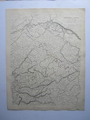
Central India
Verlag: Chapman & Hall, London, 1848
Anbieter: Angelika C. J. Friebe Ltd. - MapWoman, Dorking, Vereinigtes Königreich
Verkäuferbewertung 5 von 5 Sternen
Karte
EUR 60,11
EUR 23,34 Versand
Versand von Vereinigtes Königreich nach USAAnzahl: 1 verfügbar
In den WarenkorbNo Binding. Zustand: Very Good. steel engraved map with original outline colouring; overall 45 x 35 cm, image 41 x 31 cm. some foxing; 1 small identation; o/w vg cond. A detailed map of Central India from the Punjab to Berar, and Marwar to Nepal. From: Sharpe's Corresponding Atlas, Comprising Fifty-Four Maps, Constructed Upon A System Of Scale And Proportion, From the most Recent Authorities. Engraved On Steel By Joseph Wilson Lowry. With A Copious Consulting Index. London: Chapman And Hall, 186 Strand. MDCCCXLIX. Maps engraved by J.Wilson Lowry.
-

England and Wales railway map / (engraved by J. Wilson Lowry)
Verlag: London: Chapman and Hall, 1847
Erstausgabe
1st edition. Good copy in the original gilt-blocked cloth. Spine bands and panel edges somewhat bumped and rubbed as with age. Remains quite well-preserved overall. Physical description: 1 map; 605 x 427 mm. Subjects: England Railways 1847; Maps. 18 miles to an inch. Electric telegraph. Railways opened. England. Wales. Other names: Sharpe, John. Genre: Map. 3 Kg.
-
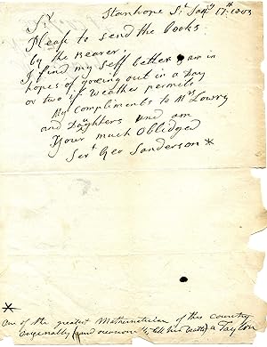
Autograph Letter Signed ('Geo Sanderson') to Lowry.
Verlag: 17 January ; Stanhope Street London, 1803
Anbieter: Richard M. Ford Ltd, London, Vereinigtes Königreich
Verkäuferbewertung 5 von 5 Sternen
Manuskript / Papierantiquität
EUR 270,50
EUR 5,25 Versand
Versand von Vereinigtes Königreich nach USAAnzahl: 1 verfügbar
In den Warenkorb8vo, 1 p. Text clear and complete. On aged and creased paper, with chipping to extremities. Thin strip of stub adhering to reverse, which carries the address in Sanderson's hand: 'Mr: Lowry | No: 57 | Tichfield St:'. He asks him to 'send the Books by the Bearer. | I find my self better & am in hopes of goeing out in a Day or two if weather permits'. He concludes by sending his compliments to Lowry's wife and daughters. Docketed in a contemporary hand at foot of page: 'One of the greatest Mathematicians of this country | Originally (and occasionally till his Death) a Taylor'. Sanderson's trade is not mentioned in his obituary in the New Monthly Magazine, February 1814, pp.91-2, where he is said to have been indebted in his last years to 'the liberality and care of his friends, Sir John and Lady Walsh and Mr. Burgoyne, whose proficiency in mathematics had enabled them justly to appreciate his extraordinary talent and acquirements'. The obituary notes his acquaintance with 'Lauden, Todd, Maskelyne, Wales, Hutton, Dalby, and Bonnycastle'.
-
The carpenter and joiner's assistant : being a comprehensive treatise on the selection, preparation, and strength of materials, and the mechanical principles of framing with their application in carpentry, joinery, and hand-railing : also a course of instruction in practical geometry, geometrical lines, drawing, projection, and perspective, and and illustrated glossary of terms used in architecture and building / by James Newlands
Verlag: Glasgow : Blackie and Son, 1860
Erstausgabe
First Edition. Worn copy bound in quarter leather over buckram boards with a gilt title to the spine. Some slight wear and tear as with age. Remains well preserved overall; bright, clean and sharp-cornered. Includes previous owner's inscription. Physical description; 291 p., CXI [i.e. CXV] leaves of plates : ill., plans ; 35 cm. Notes; "An extensive series of plates and many hundred engravings on wood." Includes index. Subjects; Carpentry. Joinery. Geometrical drawing. Framing (Building). Carpentry. Geometry and geometrical drawing. Joinery. Genres; Engraved title pages - Scotland - 1860. Engraved title pages - Scotland - 1869. Etchings - Scotland - 1860. Etchings - Scotland - 1869. Illustrated. Library bindings - England - 1894. Library bindings - England - 1934. Library bindings - England - 1974. Marbled papers - England - 1894. Steel engravings - Scotland - 1860. Steel engravings - Scotland - 1869. Treatises - Scotland - 1860. Wood engravings - Scotland - 1860. Wood engravings - Scotland - 1869. 4 Kg.
-

A Front View of the Hall of Audience at the Palace of Yuen-Min-Yuen. First edition.
Verlag: London: G. Nicol. 1796., 1796
Anbieter: Wittenborn Art Books, San Francisco, CA, USA
Verkäuferbewertung 5 von 5 Sternen
Kunst / Grafik / Poster
Zustand: Good. Engraving. Plate 22. 24 x 35 cm. image on Whatman watermakfred 1794. Sheet size 42 x 59 cm. Large Waterstain in lower maring, not affecting the4 image. k.Blick von N in die Einsiedelei in der Verenaschlucht mit der St. Verena- und der St. Martinskapelle und mit zahlreichen Staffagefiguren.Christian von Mechel est un graveur et éditeur suisse né ŕ Bâle le 4 avril 1737 et mort ŕ Berlin le 11 avril 1817.
-

BRITISH NORTH AMERICA LXVIII.
Verlag: Glasgow, Edinburgh & London. 1860, 1860
Anbieter: Peter Harrington. ABA/ ILAB., London, Vereinigtes Königreich
Verbandsmitglied: ABA ILAB PBFA
Verkäuferbewertung 5 von 5 Sternen
EUR 144,27
EUR 25,68 Versand
Versand von Vereinigtes Königreich nach USAAnzahl: 1 verfügbar
In den WarenkorbHandsome map of modern day Canada. Title located on top right corner with scale underneath. The Imperial Atlas of Modern Geography, published by Blackie and Son. Copper engraving. Good condition. Minor closed split at bottom of centre-fold. Original outline colour. Size: 50 x 34 cm.
-

BRAZIL LXXXVI.
Verlag: Glasgow, Edinburgh & London. 1860, 1860
Anbieter: Peter Harrington. ABA/ ILAB., London, Vereinigtes Königreich
Verbandsmitglied: ABA ILAB PBFA
Verkäuferbewertung 5 von 5 Sternen
EUR 144,27
EUR 25,68 Versand
Versand von Vereinigtes Königreich nach USAAnzahl: 1 verfügbar
In den WarenkorbMap of Brazil with a detailed inset at bottom left which includes the southern tip of Brazil and parts of Argentina. Taken from The Imperial Atlas of Modern Geography by Blackie & Son. Copper engraving. Fine condition, slightly age toned. Original outline colour. Size: 49.5 x 34 cm.
-
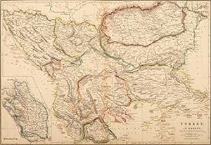
TURKEY IN EUROPE XXVII.
Verlag: Glasgow, Edinburgh & London. 1860, 1860
Anbieter: Peter Harrington. ABA/ ILAB., London, Vereinigtes Königreich
Verbandsmitglied: ABA ILAB PBFA
Verkäuferbewertung 5 von 5 Sternen
EUR 144,27
EUR 25,68 Versand
Versand von Vereinigtes Königreich nach USAAnzahl: 1 verfügbar
In den WarenkorbVery detailed map of Romania, Bosnia Yugoslavia, Bulgaria, Servia and Macedonia, Albania and part of Greece. An inset of Moldovia, Romania, is included at bottom left. Published in The Imperial Atlas of Modern Geography by Blackie & Son. Copper engraving. Good condition. Closed split runs down bottom half of centrefold. Original outline colour. Size: 49.5 x 33.5 cm.
-

VENEZUELA NEW GRANADA AND ECUADOR. LXXXIV.
Verlag: Glasgow, Edinburgh & London. 1860, 1860
Anbieter: Peter Harrington. ABA/ ILAB., London, Vereinigtes Königreich
Verbandsmitglied: ABA ILAB PBFA
Verkäuferbewertung 5 von 5 Sternen
EUR 174,33
EUR 25,68 Versand
Versand von Vereinigtes Königreich nach USAAnzahl: 1 verfügbar
In den WarenkorbAttractive map of Venezuela, Columbia, and Ecuador. Title located at bottom right with scale below. From The Imperial Atlas of Modern Geography by Blackie & Son. Copper engraving. Good condition, slightly age toned. Original outline colour. Size: 50 x 34 cm.
-
Eastern Persia
Verlag: Chapman and Hall, London, 1848
Anbieter: Alexandre Antique Prints, Maps & Books, Toronto, ON, Kanada
Verkäuferbewertung 4 von 5 Sternen
Karte
Zustand: Very Good; A detailed and correct map of Eastern Persia.Mountain chains and seas are strongly shaded.It was published during the reign of Mohammad Shah Qajar., Size : 410x314 (mm), 16.14x12.36 (Inches), Original Outline Coloring, 0.
-

CANADA WEST, AND PART OF CANADA EAST LXIX.
Verlag: Glasgow, Edinburgh & London. 1860, 1860
Anbieter: Peter Harrington. ABA/ ILAB., London, Vereinigtes Königreich
Verbandsmitglied: ABA ILAB PBFA
Verkäuferbewertung 5 von 5 Sternen
EUR 198,37
EUR 25,68 Versand
Versand von Vereinigtes Königreich nach USAAnzahl: 1 verfügbar
In den WarenkorbDetailed map of West Canada. A list of the counties and districts of Canada West and East is included. An inset of Montreal is located at top left. Published in The Imperial Atlas of Modern Geography by Blackie & Son. Copper engraving. Good condition. Original outline colour. Size: 50 x 34 cm.
-
Western Persia
Verlag: Chapman and Hall, London, 1848
Anbieter: Alexandre Antique Prints, Maps & Books, Toronto, ON, Kanada
Verkäuferbewertung 4 von 5 Sternen
Karte
Zustand: Very Good; A detailed and correct map of Western Persia.Mountain chains and seas are strongly shaded.It was published during the reign of Mohammad Shah Qajar., Size : 410x314 (mm), 16.14x12.36 (Inches), Original Outline Coloring, 0.
-

THE UNITED STATES __ VALLEY OF THE MISSISSIPPI LXXIII.
Verlag: Glasgow, Edinburgh & London. 1860, 1860
Anbieter: Peter Harrington. ABA/ ILAB., London, Vereinigtes Königreich
Verbandsmitglied: ABA ILAB PBFA
Verkäuferbewertung 5 von 5 Sternen
EUR 234,44
EUR 25,68 Versand
Versand von Vereinigtes Königreich nach USAAnzahl: 1 verfügbar
In den WarenkorbFrom Lake Superior to the Gulf coast, this is a detailed map of the southern and central states along the Mississippi River. The southern tip of Louisiana overlaps the bottom margin and the states east of the river overlap the right margin. Published in The Imperial Atlas of Modern Geography by Blackie. See also stock no. 7173. Copper engraving. Good condition. Original outline colour. Size: 34 x 49.5 cm. (13˝ x 19˝ inches).
-

EUROPE III.
Verlag: Glasgow, Edinburgh & London. 1860, 1860
Anbieter: Peter Harrington. ABA/ ILAB., London, Vereinigtes Königreich
Verbandsmitglied: ABA ILAB PBFA
Verkäuferbewertung 5 von 5 Sternen
EUR 234,44
EUR 25,68 Versand
Versand von Vereinigtes Königreich nach USAAnzahl: 1 verfügbar
In den WarenkorbDetailed map of Europe with scale at bottom right. The Imperial Atlas of Modern of Modern Geography by Blackie & Son. Copper engraving. Good condition. Minor repaired split on the bottom centrefold. Original outline colour. Size: 48.5 x 33.5 cm.
-

THE UNITED STATES OF NORTH AMERICA. ATLANTIC STATES AND VALLEY OF THE MISSISSIPPI. (IN TWO SHEETS) LXXII.
Verlag: Glasgow, Edinburgh & London. 1860, 1860
Anbieter: Peter Harrington. ABA/ ILAB., London, Vereinigtes Königreich
Verbandsmitglied: ABA ILAB PBFA
Verkäuferbewertung 5 von 5 Sternen
EUR 264,49
EUR 25,68 Versand
Versand von Vereinigtes Königreich nach USAAnzahl: 1 verfügbar
In den WarenkorbOne sheet only showing the east coast of the United States from the southern parts of Canada and the Great Lakes to Florida. A detailed inset is included at bottom right showing the continuation of Florida. From The Imperial Atlas of Modern Geography by Blackie & Son. See also stock no. 7172. Copper engraving. Good condition though slightly age toned. Original outline colour. Size: 34 x 49.5 cm. (13˝ x 19˝ inches).
-

The United States of North America, Pacific States
Verlag: The Imperial Atlas of Modern Geography; an extensive series of maps, embracing the most recent discoveries and the latest political divisions of territory in all parts of the World. Walter Grahame Blackie. 1860, 1860
Anbieter: Peter Harrington. ABA/ ILAB., London, Vereinigtes Königreich
Verbandsmitglied: ABA ILAB PBFA
Verkäuferbewertung 5 von 5 Sternen
EUR 354,66
EUR 25,68 Versand
Versand von Vereinigtes Königreich nach USAAnzahl: 1 verfügbar
In den WarenkorbLovely map of the west coast showing Washington, Oregon, California, Utah and New Mexico. Title at bottom left with scale below. Copper engraving. Very good condition. Original outline colour. Size: 34 x 25 cm (13 ˝ x 10 inches).
-
Antique Print-PNEUMATICS-SCIENCE-AIR-HYGROMETER-BAROMETER-Lowry-Howard-1788
Erscheinungsdatum: 1788
Anbieter: Pictura Prints, Art & Books, Overasselt, Niederlande
Verkäuferbewertung 5 von 5 Sternen
Kunst / Grafik / Poster
'"PNEUMATICS, OR THE SCIENCE OF AIR"'This print shows a view on a collection of scientific instruments used in the 18th century to study the properties of air and liquids. Hydrometers: Instruments for measuring the density or specific gravity of liquids (shown above, such as Fig. 25 and 26). Hygrometers: Devices for measuring humidity (the middle part). You will see different mechanical designs, including types that worked with strings or hairs that expand with moisture. Barometers and Pressure Gauges: Various air pressure measuring devices, including a circular scale at the bottom (Fig. 42) indicating the states "Very Dry", "Settled Fair", "Changeable", "Rain" and "Much Rain".Made by Wilson Lowry after Howard.Medium: Etching / engraving on handlaid (verge) paper.Sheet size: 26 x 42 cm (10.24 x 16.54 inch). Image size: 21 x 35.2 cm. (8.27 x 13.86 inch).PNEUMATICS-SCIENCE-AIR-LIQUIDS-HYGROMETER-BAROMETER-PRESSURE-WEATHER | RBOS-T43-LARGEBACKGROUND INFORMATIONThis attractive print was published in the New Royal Cyclopaedia and Encyclopaedia" (ook bekend als The New Royal Encyclopaedia Londinensis), samengesteld door George Selby Howard, 1788. Published by Alexander Hogg in Londen. Condition: good, given age. Brown edges. General age-related toning and/or occasional minor defects from handling. Please study scan carefully.

![Bild des Verkäufers für TABULAR VIEW OF CHARACTERISTIC BRITISH FOSSILS, stratigraphically arranged. Containing nearly 600 figures of the more prominent forms of organic remains found in British Strata, arranged in the order of their occurrence, together with a column showing the succession of the strata with the thickness and mineral character of the principal members of each formation. [London: Edward Stanford, Geographer to His Majesty the King. 12, 13, and 14 Long Acre, W.C.] [n.d. but post zum Verkauf von Deborah Coltham Rare Books](https://pictures.abebooks.com/inventory/md/md32055530533.jpg)
