Lieutenant colonel salmon (4 Ergebnisse)
 Weitere Bilder
Sprache: Französisch
Verlag: A. Fayard, Paris
- Softcover
Anbieter: Librairie RAIMOND, Dourges, , FrankreichLibrairie RAIMOND
Verkäufer/-in kontaktierenVerkäufer/-in mit 5 SternenZustand: Gebraucht - Gut bis sehr gut
EUR 25,00
EUR 20,00 VersandVersand von Frankreich nach USAAnzahl: 1 verfügbar
Couverture souple. Zustand: Bon. Lieutenant-Colonel SALMON LES GRANDS EXPLORATEURS AU PAYS DE LA SOIF - LE SAHARA : DUVEYRIER - SOLEILLET - GERARD ROHLFS - GENERAL MARGUERITTE Sans date circa fin XIXe siècle, Paris, Edition A. Fayard Format : In-16 (14,5 x 10 cm), broché, 158 pages illustré d'une carte des possessions françaises… d'Afrique Etat : couverture légèrement écorchée, papier bruni, livre solide poids : 220g.

Verlag: A. FAYARD
- Softcover
Anbieter: Le-Livre, SABLONS, , FrankreichLe-Livre
Verkäufer/-in kontaktierenVerkäufer/-in mit 5 SternenZustand: Gebraucht - Gut bis sehr gut
EUR 65,25
EUR 42,00 VersandVersand von Frankreich nach USAAnzahl: 1 verfügbar
Couverture souple. Zustand: bon. RO20146641: Non daté. In-16. Broché. Bon état, Couv. convenable, Dos satisfaisant, Intérieur frais. 160 pages. Une carte en noir et blanc, hors texte. . . . Classification Dewey : 940-Histoire générale de l'Europe.

Verlag: FAYARD A.
- Hardcover
Anbieter: Le-Livre, SABLONS, , FrankreichLe-Livre
Verkäufer/-in kontaktierenVerkäufer/-in mit 5 SternenZustand: Gebraucht - Gut bis sehr gut
EUR 85,00
EUR 42,00 VersandVersand von Frankreich nach USAAnzahl: 1 verfügbar
Couverture rigide. Zustand: bon. R320077628: NON DATE. In-18. Relié. Bon état, Plats abîmés, Dos satisfaisant, Intérieur frais. 159 + 160 + 156 pages. . . . Classification Dewey : 904-Recueils de récits d'événements.
Verlag: Ordnance Survey, Southampton 1958
- Softcover
- Karte
Anbieter: Khalkedon Rare Books ABA, ILAB, IOBA, ESA, Istanbul, TürkeiKhalkedon Rare Books ABA, ILAB, IOBA, ESA
Verkäufer/-in kontaktierenVerkäufer/-in mit 5 SternenZustand: Gebraucht - Gut
EUR 134,79
EUR 18,00 VersandVersand von Türkei nach USAAnzahl: 1 verfügbar
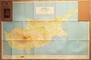
Soft cover. Zustand: Very Good. 3rd Edition. Revised Third Edition of this rare map of Cyprus, made by Salmon, who was the director of Cypriot land registration and surveys. "Shows grid, district boundaries, heights in feet, railways, roads (2 categories), antiquities, ancient sites.". / "Shows district boundaries, towns and cit…ies, roads (2 categories), railroads, ancient sites and antiquities, and dry streams. Relief is shown by contours, gradient tints, and spot heights. Earlier Edition: 1952.". (OCLC). "In December 1926, in a memorandum to the Colonial Office on vacant surveying positions in the colonies, Palestine and Cyprus were mentioned at the end of a group of Mediterranean colonies; that is there was a group of Mediterranean colonies, and also Cyprus and Palestine [.] Only in 1929 was an Imperial project involving Palestine and Transjordan, brought up at the committee (Colonial Survey Committee). This was the experimental aerial survey for determining the route of the Haifa - Damascus railway, which was presented as a model for mapping from aerial photographs [.] Among the important things reported to the Colonial Survey Committee was the reconnaissance conducted by Colonial Winterbotham, the Chief of the GSGS, in the survey departments of the colonies in 1929, a trip that had been encouraged in the first Conference of Empire Survey Officers in 1928 [.] . how much Salmon [F. J.] expected from Winterbotham's visit to Ceylon a short time before he was to take over the directorship of the small survey department of Cyprus.". (Source: The Survey of Palestine Under the British Mandate, 1920-1948). Original color map. Folded in original wrappers. Fine. Elephant folio. (58 x 89 cm). In English. Survey of Cyprus administration map. Scale of 4 miles to one inch = 1/253440. Compiled and drawn under the direction of F. J. SALMON, (Director of Land Registration and Surveys, Cyprus, 1932). Revised Third Edition. Second in 1950.


