
Gesamtpreis (1 Artikel Artikel):
Versandziel:

legenisel (11 Ergebnisse)
Direkt zu den wichtigsten Suchergebnissen
Suchfilter
Produktart
- Alle Product Types
- Bücher (5)
- Magazine & Zeitschriften (Keine weiteren Ergebnisse entsprechen dieser Verfeinerung)
- Comics (Keine weiteren Ergebnisse entsprechen dieser Verfeinerung)
- Noten (Keine weiteren Ergebnisse entsprechen dieser Verfeinerung)
- Kunst, Grafik & Poster (1)
- Fotografien (Keine weiteren Ergebnisse entsprechen dieser Verfeinerung)
- Karten (5)
- Manuskripte & Papierantiquitäten (Keine weiteren Ergebnisse entsprechen dieser Verfeinerung)
Zustand Mehr dazu
- Neu (Keine weiteren Ergebnisse entsprechen dieser Verfeinerung)
- Wie Neu, Sehr Gut oder Gut Bis Sehr Gut (5)
- Gut oder Befriedigend (1)
- Ausreichend oder Schlecht (Keine weiteren Ergebnisse entsprechen dieser Verfeinerung)
- Wie beschrieben (5)
Einband
- alle Einbände
- Hardcover (Keine weiteren Ergebnisse entsprechen dieser Verfeinerung)
- Softcover (2)
Weitere Eigenschaften
- Erstausgabe (1)
- Signiert (1)
- Schutzumschlag (Keine weiteren Ergebnisse entsprechen dieser Verfeinerung)
- Angebotsfoto (11)
Sprache (2)
Gratisversand
Land des Verkäufers
Verkäuferbewertung
-

First Edition. Very good paperback copy; edges somewhat dust-dulled and nicked. Remains quite well-preserved overall. Physical description: 172 pages ; 20 cm. Subjects: French history; Medieval history. 3 Kg.
-
Histoire de Dinan ŕ travers les âges avec plan actuel
Verlag: O.-L. Aubert, Saint-Brieuc, 1930
Anbieter: Librairie Aubry, Cormeray, Frankreich
Verkäuferbewertung 5 von 5 Sternen

Couverture souple. Zustand: Bon. Couverture légčrement défraîchie. Bon état. Réf 24493. In-8°, 166 pages, broché (278g).
-
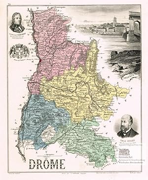
Drome. Antique Map. Dekorative Landkarte mit Ansicht und Stadtwappen von Valence und Portraits von Emile Augier sowie Etienne Jean Championnet. Lithographie von Legenisel nach Vuillemin bei Migeon um 1880
Sprache: Französisch
Verlag: Paris: Imprimerie Migeon um, 1880
Anbieter: historicArt Antiquariat & Kunsthandlung, Wiesbaden-Breckenheim, Deutschland
Verkäuferbewertung 5 von 5 Sternen
Karte Signiert
Lithographie von Legenisel (im Stein signiert) nach einer Zeichnung von A. Vuillemin auf rückseitig unbedrucktem Blatt, alt flächenkoloriert, Blattgröße ca. 34 x 25 cm, gut erhalten, Beilage: ganzseitige Originalbeschreibung der Provinz in französischer Sprache 1100 gr.
-

1 carte gravée en couleurs de l'Indre - N°35
Verlag: IMP. MIGEON
Karte
Pas de couverture. Zustand: bon. RO80091071: XIXe sičcle. In-4. En feuillets. Bon état, Livré sans Couverture, Dos satisfaisant, Intérieur acceptable. Une planche ( de 34.5 x 26.5 cm) illustrée d'une carte en couleurs et de quelques gravures en noir et blanc. . . . Classification Dewey : 912-Atlas, cartes et plans.
-

1 carte gravée en couleurs du Doubs - N°24
Verlag: IMP. MIGEON
Karte
Pas de couverture. Zustand: bon. RO80091066: XIXe sičcle. In-4. En feuillets. Bon état, Livré sans Couverture, Dos satisfaisant, Intérieur acceptable. Une planche ( de 34.5 x 26.5 cm) illustrée d'une carte en couleurs et de quelques gravures en noir et blanc. . . A l'italienne. Classification Dewey : 912-Atlas, cartes et plans.
-

1 carte gravée en couleurs du Jura - N°38
Verlag: IMP. MIGEON
Karte
Pas de couverture. Zustand: bon. RO80091074: XIXe sičcle. In-4. En feuillets. Bon état, Livré sans Couverture, Dos satisfaisant, Intérieur acceptable. Une planche ( de 34.5 x 26.5 cm) illustrée d'une carte en couleurs et de quelques gravures en noir et blanc. . . . Classification Dewey : 912-Atlas, cartes et plans.
-

1 carte gravée en couleurs de l'Ardčche - N°6
Verlag: IMP. MIGEON
Karte
Pas de couverture. Zustand: bon. RO80091053: XIXe sičcle. In-4. En feuillets. Bon état, Livré sans Couverture, Dos satisfaisant, Intérieur acceptable. Une planche (34.5 x 26.5 cm) illustrée d'une carte en couleurs et de quelques gravures en noir et blanc. . . . Classification Dewey : 912-Atlas, cartes et plans.
-

Antique Map-ILLE-ET-VILAINE-FRANCE-Legenisel-Barbier-Migeon-Bizet-1890
Erscheinungsdatum: 1890
Anbieter: Pictura Prints, Art & Books, Overasselt, Niederlande
Verkäuferbewertung 5 von 5 Sternen
J. Migeon (dir.) / A. Bizet (scribe) (illustrator). 'LA FRANCE / ILLE ET VILAINE / GRAVE PAR LEGENISEL ET PAR BARBIER / DRESSE SOUS LA DIRECTION DE J. MIGEON / MIGEON, EDITEUR. IMP. LL. R. DU MOULIN VERT PARIS / LE TRAIT ET LA LETTRE PAR A. BIZET'Antique map of Ille-et-Vilaine, France, with coloured arrondissements. Features portraits, and view of Rennes.Made by Legenisel and Barbier after J. Migeon (dir.) / A. Bizet (scribe).Medium: Steel engraving with original hand colouring on wove (vellin) paper.Sheet size: 26.7 x 40.6 cm (10.51 x 15.98 inch). Image size: 26.5 x 38.1 cm. (10.43 x 15 inch).ANTIQUE MAP FRANCE DEPARTEMENT 1890 FRENCH ATLAS MIGEON CITY VIEW PORTRAIT ENGRAVINGBACKGROUND INFORMATIONFrom "Nouvel Atlas Illustre: La France et ses colonies", published ca. 1890 by Migeon.Biography engraver: Barbier and Walter were 19th-century French engravers.Biography artist: J. Migeon (fl. 1854-1899) was a notable 19th-century French publisher of decorative atlases. A. Bizet contributed cartographic lettering to many Migeon maps. Condition: good, given age. Light foxing, creasing, and soiling. Remains of holes at top from binding. General age-related toning and/or occasional minor defects from handling. Please study scan carefully.
-

Antique Map-GERS-FRANCE-Dyonnet-Legenisel-Barbier-Vuillemin-1890
Erscheinungsdatum: 1890
Anbieter: Pictura Prints, Art & Books, Overasselt, Niederlande
Verkäuferbewertung 5 von 5 Sternen
Alexandre Aime Vuillemin (illustrator). 'LA FRANCE / GERS / GRAVE PAR CH. DYONNET. LEGENISEL ET BARBIER / DRESSE PAR VUILLEMIN / MIGEON IMP. EDIT.R LL. DU MOULIN VERT, PARIS'Antique map of Gers, France with colour-coded arrondissements. Includes three portraits, the coat of arms, and a cityscape of Auch.Made by Ch. Dyonnet. Legenisel and Barbier after Alexandre Aime Vuillemin.Medium: Steel engraving with original hand colouring on wove (vellin) paper.Sheet size: 26.7 x 40.6 cm (10.51 x 15.98 inch). Image size: 26.5 x 38.1 cm. (10.43 x 15 inch).ANTIQUE MAP FRANCE DEPARTEMENT 1890 FRENCH ATLAS MIGEON CITY VIEW PORTRAIT ENGRAVINGBACKGROUND INFORMATIONFrom "Nouvel Atlas Illustre: La France et ses colonies", published ca. 1890 by Migeon.Biography engraver: Ch. Dyonnet. Legenisel and Barbier were 19th-century French engravers.Biography artist: Alexandre Aime Vuillemin (1812-1880) was an engraver, publisher, and editor based in Paris, France in the middle of the 19th century. Despite a prolific publishing career, much of Vuillemin's life is shrouded in mystery. In 1852, he married Josephine Caroline Goret and they had at least one child, Ernestine Adčle Vuillemin, later in the same year. What is known is that his studied under the prominent French Auguste Henri Dufour (1798 - 1865). Vuillemin's most important work his detailed, highly decorative large format Atlas Illustre de Geographie Commerciale et Industrielle. Condition: good, given age. Light foxing, creasing, and soiling. Remains of holes at top from binding. General age-related toning and/or occasional minor defects from handling. Please study scan carefully.
-

Antique Map-EURE-FRANCE-Bizet-Legenisel-Barbier-Migeon-1890
Erscheinungsdatum: 1890
Anbieter: Pictura Prints, Art & Books, Overasselt, Niederlande
Verkäuferbewertung 5 von 5 Sternen
J. Migeon (illustrator). 'LA FRANCE / EURE / GRAVE PAR BIZET, LEGENISEL ET BARBIER / DRESSE SOUS LA DIRECTION DE J. MIGEON / MIGEON, EDITEUR. IMP. LL. R. DU MOULIN VERT PARIS'Antique map of Eure, France. Features a view of Evreux and portraits of notable figures.Made by Bizet, Legenisel and Barbier after J. Migeon.Medium: Steel engraving with original hand colouring on wove (vellin) paper.Sheet size: 26.7 x 40.6 cm (10.51 x 15.98 inch). Image size: 26.5 x 38.1 cm. (10.43 x 15 inch).ANTIQUE MAP FRANCE DEPARTEMENT 1890 FRENCH ATLAS MIGEON CITY VIEW PORTRAIT ENGRAVINGBACKGROUND INFORMATIONFrom "Nouvel Atlas Illustre: La France et ses colonies", published ca. 1890 by Migeon.Biography engraver: Bizet, Legenisel and Barbier were 19th-century French engravers.Biography artist: J. Migeon (fl. 1854-1899) was a notable 19th-century French publisher of decorative atlases. A. Bizet contributed cartographic lettering to many Migeon maps. Condition: good, given age. Light foxing, creasing, and soiling. Remains of holes at top from binding. General age-related toning and/or occasional minor defects from handling. Please study scan carefully.
-

L'Occupation.
Verlag: Paris: De Launay., 1774
Anbieter: Wittenborn Art Books, San Francisco, CA, USA
Verkäuferbewertung 5 von 5 Sternen
Kunst / Grafik / Poster
Zustand: Good. Color engraving. Later printing. Image: 21.5 x 28 cm. Sheet: 35 x 47.5 cm.
