Gesamtpreis (1 Artikel Artikel):
Versandziel:

krevelt (26 Ergebnisse)
Direkt zu den wichtigsten Suchergebnissen
Suchfilter
Produktart
- Alle Product Types
- Bücher (15)
- Magazine & Zeitschriften (Keine weiteren Ergebnisse entsprechen dieser Verfeinerung)
- Comics (Keine weiteren Ergebnisse entsprechen dieser Verfeinerung)
- Noten (Keine weiteren Ergebnisse entsprechen dieser Verfeinerung)
- Kunst, Grafik & Poster (8)
- Fotografien (Keine weiteren Ergebnisse entsprechen dieser Verfeinerung)
- Karten (3)
- Manuskripte & Papierantiquitäten (Keine weiteren Ergebnisse entsprechen dieser Verfeinerung)
Zustand Mehr dazu
- Neu (2)
- Wie Neu, Sehr Gut oder Gut Bis Sehr Gut (1)
- Gut oder Befriedigend (13)
- Ausreichend oder Schlecht (Keine weiteren Ergebnisse entsprechen dieser Verfeinerung)
- Wie beschrieben (10)
Einband
- alle Einbände
- Hardcover (1)
- Softcover (Keine weiteren Ergebnisse entsprechen dieser Verfeinerung)
Weitere Eigenschaften
- Erstausgabe (Keine weiteren Ergebnisse entsprechen dieser Verfeinerung)
- Signiert (7)
- Schutzumschlag (Keine weiteren Ergebnisse entsprechen dieser Verfeinerung)
- Angebotsfoto (21)
Sprache (1)
Gratisversand
- Kostenloser Versand nach USA (Keine weiteren Ergebnisse entsprechen dieser Verfeinerung)
Land des Verkäufers
Verkäuferbewertung
-

EUR 17,99
EUR 14,50 Versand
Versand von Zypern nach USAAnzahl: Mehr als 20 verfügbar
In den WarenkorbLoose Leaf. Zustand: New. Reproduction. Original title: Map of Friesland German: Karte von Friesland French: Carte de Friesland Spanish: Mapa de Frisia High-quality fine-art reproduction based on an original work from the Rijksmuseum. Creation period: 18th century (1782). Professionally printed on premium fine-art paper (Photo Matt Fibre) in size A5. The motif is printed with a white border (museum-style presentation). No.
-

EUR 17,99
EUR 14,50 Versand
Versand von Zypern nach USAAnzahl: Mehr als 20 verfügbar
In den WarenkorbLoose Leaf. Zustand: New. Reproduction. Original title: World Map German: Weltkarte French: Carte du monde Spanish: Mapa del mundo High-quality fine-art reproduction based on an original work from the Rijksmuseum. Creation period: 18th century (1772). Professionally printed on premium fine-art paper (Photo Matt Fibre) in size A5. The motif is printed with a white border (museum-style presentation). No.
-

Carte de la Guiane, Pour Servir a 'Hist. des Etablissemens Europeens
Verlag: Amsterdam, 1773, 1773
Anbieter: Pennymead Books PBFA, Knaresborough, Vereinigtes Königreich
Verbandsmitglied: PBFA
Verkäuferbewertung 5 von 5 Sternen

EUR 46,36
EUR 17,38 Versand
Versand von Vereinigtes Königreich nach USAAnzahl: 1 verfügbar
In den WarenkorbHand coloured, engraved map of the coastline. Toning in margin only. Fine condition. 12.5 x 9" Includes Fort Nassau and Fort New Amsterdam.
-

Nieuwe Genrale kaart van Europa volgens de laatste ontdekkingen van Capt. Cook.
Anbieter: Rob Kok Old Books & Prints, Loosdrecht, NH, Niederlande
Verkäuferbewertung 4 von 5 Sternen

1786. Handcoloured map. 20,5 x 24 cm. Folded. Taken from: Compleete zak-atlas van de zeventien Nederlandsche Provinciën. Amsteldam, Elwe en Langeveld, 1786. [100392].
-
Nieuwe Genrale kaart van Asia volgens de laatste ontdekkingen van Capt. Cook.
Anbieter: Rob Kok Old Books & Prints, Loosdrecht, NH, Niederlande
Verkäuferbewertung 4 von 5 Sternen
1786. Handcoloured map. 20,5 x 24 cm. Folded. Taken from: Compleete zak-atlas van de zeventien Nederlandsche Provinciën. Amsteldam, Elwe en Langeveld, 1786. [100393].
-
Nieuwe Genrale kaart van Africa volgens de laatste ontdekkingen van Capt. Cook.
Anbieter: Rob Kok Old Books & Prints, Loosdrecht, NH, Niederlande
Verkäuferbewertung 4 von 5 Sternen
1786. Handcoloured map. 20,5 x 24 cm. Folded. Taken from: Compleete zak-atlas van de zeventien Nederlandsche Provinciën. Amsteldam, Elwe en Langeveld, 1786. [100394].
-

Nieuwe Kaart van Friesland
Verlag: Jacobus Kok, 1781
Anbieter: Antiquariaat Dat Narrenschip, Middelburg, Niederlande
Verkäuferbewertung 5 von 5 Sternen
Karte
No Binding. Zustand: Fine. Oude, antieke landkaart van de provincie Friesland. Titel met het wapen van Friesland links onder; schaalstok rechts onder en windroos onder Terschelling. Gegraveerd door A. van Krevelt in 1781. Rugzijde blank. Oudtijds gekleurde kopergravure, uitgegeven in 1782 te Amsterdam in "Vaderlandsch Woordenboek," Jacobus Kok. Afmetingen (afbeelding): 33 x 43 cm.
-

Zustand: ACEPTABLE. Suivant les Plans des Hollandois Formato (cm): 23x28.
-

Zustand: ACEPTABLE. Sur ce que les Anglois et les Hollandois en ont publié Formato (cm): 23x28.
-

Carte des entrees des Rivieres de Demerary et D'Essequero
Verlag: Amsterdam, 1773
Kunst / Grafik / Poster
Zustand: ACEPTABLE. Suivant les Plans des Hollandois Formato (cm): 23x28.
-

Zustand: ACEPTABLE. Suivant les Plans des Hollandois Formato (cm): 23x28.
-

Carte Particuliere D'une Partie des Rivieres de Berbice et de Canje, Por L'Intelligence de la Relation touchant La Revolte des Negres en 1763
Verlag: Amsterdam, 1773
Kunst / Grafik / Poster
Zustand: ACEPTABLE. Formato (cm): 28x20.
-

Carte de l'Islande Pour servir ŕ l'Histoire Générale des Voyages.
Verlag: Artist: Krevelt A V Amsterdam ca :, 1778
Anbieter: Antique Sommer& Sapunaru KG, München, Deutschland
Verkäuferbewertung 4 von 5 Sternen
Technic: Copper print, colorit: colored, condition: Some folds, size (in cm): 29,5 x 37,5, Map shows total Iceland.
-
Compleete Zak-Atlas, van der Zeventien Nederlandsche Provincien, begreepen in XXXI, zeer naauwkeurig en zindfelyk in [Text in Unknown]t koper gebragte Kaarten, Op nieuw vervaardigd, nar bde laatste verbeteringen. . van de Heeren, Fraex, Bachine, und andere voornaame Aardryks-Kundigen: Waar by gevoegd is, een Algemeen denkbeeld van de Aardryks-kunde, Benevens eene korte beschtyving der XVII Nederlandsche Provincien .
Erscheinungsdatum: 1786
Anbieter: Maggs Bros. Ltd ABA, ILAB, PBFA, London, Vereinigtes Königreich
Verbandsmitglied: ABA ILAB PBFA
Verkäuferbewertung 5 von 5 Sternen
Karte
EUR 3.281,02
EUR 31,28 Versand
Versand von Vereinigtes Königreich nach USAAnzahl: 1 verfügbar
In den WarenkorbSecond edition under this title; octavo (203 x 117); double-page engraved title-page, 243, [1]pp., twenty-nine folding engraved maps, two folding engraved distance tables, all in fine original wash colour, a very good example. Contemporary half calf over speckled paper-covered boards, gilt, red morocco label to spine; joints and spine recently repaired, boards slightly rubbed. Amsterdam : Jan Barend Elwe & Dirk Meland Langeveld, Third edition of this atlas of the Low Countries, first published by [Johanna] Wedue de Josua Ottens in about 1770, and then reprinted under this title by Elwe and Langeveld in 1785, with this edition appearing in 1786. The Ottens atlas contained only the series of Low Country maps, while Elwe and Langeveld?s version inserted Krevelt?s maps of the world and four continents: Europe, Africa, Asia and the Americas. The atlas is preceded by a general geographical introduction, followed by a description of the different parts of the Netherlands. Reference: Koeman, E & L 2, recording only the Library of Congress example of this edition, and Ott 10: the first appearances of the Low Countries maps.
-

Antique Map of Paraguay by A. van Krevelt (1771)
Erscheinungsdatum: 1771
Anbieter: Bartele Gallery - The Netherlands, Langweer, FRL, Niederlande
Verkäuferbewertung 5 von 5 Sternen
Karte
No Binding. Zustand: Good. Antique map titled 'Carte du Paraguay et des Pays voisins'. Detailed map of the part of South America bounded by La Paz, Rio de Janeiro, Montevideo and the Pacific. Rio de la Plata and its tributaries are most prominent. General age-related toning, minor defects from handling. Please study image carefully. Overall size: 33 x 25 cm. Image size: 31 x 21 cm. The collection of Bartele Gallery includes over 50,000 authentic antique maps, sea charts, prints and books. Our Abebooks store includes a selection of maps, prints and books for SALE prices. Please visit our other online sales channels to explore our complete collection of original antique maps and prints!
-
Nieuwe Genrale kaart van Amerika, volgens de laatste ontdekkingen van Cook
Anbieter: Rob Kok Old Books & Prints, Loosdrecht, NH, Niederlande
Verkäuferbewertung 4 von 5 Sternen
1786. Handcoloured map. 20,5 x 24 cm. Folded. Taken from: Compleete zak-atlas van de zeventien Nederlandsche Provinciën. Amsteldam, Elwe en Langeveld, 1786. [100421].
-
Antique Map-EUROPE-CAPTAIN COOK-Krevelt-1786
Erscheinungsdatum: 1786
Anbieter: Pictura Prints, Art & Books, Overasselt, Niederlande
Verkäuferbewertung 5 von 5 Sternen
'"NIEUWE GENERALE KAART VAN EUROPA VOLGENS DE LAATSTE ONTDEKKINGEN VAN CAPT COOK AMSTERDAM". 'This print shows a view on a map of Europe.Made by after an anonymous artist.Medium: engraving on handlaid (verge) paper.Sheet size: 23 x 19.5 cm (9.06 x 7.68 inch). Image size: 21.5 x 18 cm. (8.46 x 7.09 inch).MAP-EUROPE-CAPTAIN COOK | RBOS-A10-38BACKGROUND INFORMATIONThis attractive print was published by Jan Barend Elwe in 1786. He was a Dutch book seller and publisher, active in Amsterdam at the end of the 18th century. He reissued maps by Sanson, Jaillot, de l'Isle and Ottens. Condition: good, given age. Smudges. Old restoration of tear. Folds as published. Brownish. Thin spot. General age-related toning and/or occasional minor defects from handling. Please study scan carefully.
-
Antique Print-BRASIL-COAST-AMAZONE-RECIFE-IGARASU-van Krevelt -1772
Erscheinungsdatum: 1772
Anbieter: Pictura Prints, Art & Books, Overasselt, Niederlande
Verkäuferbewertung 5 von 5 Sternen
Kunst / Grafik / Poster
'CARTE DU BRESIL (.)'This print shows a map of the Brasilian coast, near the river Amazone. Igarasu and Recife are indicated incorrectly on this map. Both are shown nearby Maranhao while they are situated near Olinda.Made by after an anonymous artist.Medium: Engraving with hand colouring on hand laid (verge paper.Sheet size: 40.7 x 27 cm (16.02 x 10.63 inch). Image size: 33 x 23.5 cm. (12.99 x 9.25 inch).BRASIL-COAST-AMAZONE-RECIFE-IGARASU | RBOS-A8-11BACKGROUND INFORMATIONThis attractive print was published in Amsterdam, 1772.Biography engraver: Abram van Krevelt (1732-1784) was a Dutch engraver of maps and characters, active in Amsterdam. Condition: good, given age. Folds as published. Creases. Small stains. Tear at top right margin, backed. General age-related toning and/or occasional minor defects from handling. Please study scan carefully.
-
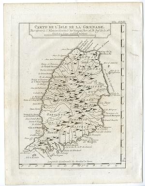
Antique Print-GRENADA-GRENADE-CARIBBEAN-Prevost-1777
Erscheinungsdatum: 1777
Anbieter: Pictura Prints, Art & Books, Overasselt, Niederlande
Verkäuferbewertung 5 von 5 Sternen
Signiert
Zustand: Very Good. Jacques Nicolas Bellin (illustrator). 'Carte de l'Isle de la Grenade.'Engraving / etching on hand laid (verge) paper. Sheet size: 19,5 x 25,5 cm. (7,7 x 10 inch). Image size: 15,2 x 21 cm. (6 x 8,3 inch).From a Dutch edition of Prevost's monumental work: 'Historische Beschryving der Reizen [.]', published in Amsterdam by E. van Harrevelt and d. J. Changuion, 1777. Antoine Francois Prevost d'Exiles (or Abbe Prevost's) multi-volume 'Histoire Generale Des Voyages' (1746-1759): ultimately 17 quarto volumes recounting major voyages of discovery and descriptions of far flung parts and including around 240 maps, plans and charts of those areas. These maps, plans and charts were mostly produced by Jacques Nicolas Bellin, the influential French hydrographer. Bellin's work spans from around 1740 to the 1770s; interestingly he signed his plates in a variety of styles: J. Bellin, N. Bellin, N.B., M.B. (Monsieur Bellin) and S.B. (Seigneur Bellin).Made by 'A. van Krevelt' after 'Jacques Nicolas Bellin'. Abram van Krevelt (1732-1784) was a Dutch draughtsman and engraver. Antoine Francois Prevost d'Exiles (1697-1763), usually known simply as the Abbe Prevost, was a French author and novelist.Condition: Very good, given age. Original vertical folds as issued. General age-related toning and/or occasional minor defects from handling. Please study scan carefully.Keywords: GRENADA-GRENADE-CARIBBEANPCO-A29-03.
-
Antique Print-DOMINICAN REPUBLIC-SAINT DOMINGUE-Prevost-Bellin-1777
Erscheinungsdatum: 1777
Anbieter: Pictura Prints, Art & Books, Overasselt, Niederlande
Verkäuferbewertung 5 von 5 Sternen
Signiert
Zustand: Very Good. Jacques Nicolas Bellin (illustrator). 'Carte de l'Isle de Saint Domingue (.).'Engraving / etching on hand laid (verge) paper. Sheet size: 31,5 x 23 cm. (12,4 x 9,1 inch). Image size: 28,5 x 19 cm. (11,2 x 7,5 inch).From a Dutch edition of Prevost's monumental work: 'Historische Beschryving der Reizen [.]', published in Amsterdam by E. van Harrevelt and d. J. Changuion, 1777. Antoine Francois Prevost d'Exiles (or Abbe Prevost's) multi-volume 'Histoire Generale Des Voyages' (1746-1759): ultimately 17 quarto volumes recounting major voyages of discovery and descriptions of far flung parts and including around 240 maps, plans and charts of those areas. These maps, plans and charts were mostly produced by Jacques Nicolas Bellin, the influential French hydrographer. Bellin's work spans from around 1740 to the 1770s; interestingly he signed his plates in a variety of styles: J. Bellin, N. Bellin, N.B., M.B. (Monsieur Bellin) and S.B. (Seigneur Bellin).Made by 'A. van Krevelt' after 'Jacques Nicolas Bellin'. Abram van Krevelt (1732-1784) was a Dutch draughtsman and engraver. Antoine Francois Prevost d'Exiles (1697-1763), usually known simply as the Abbe Prevost, was a French author and novelist.Condition: Very good, given age. Original folds as issued. General age-related toning and/or occasional minor defects from handling. Please study scan carefully.Keywords: DOMINICAN REPUBLIC-SAINT DOMINGUE-CARIBBEANPCO-A29-02.
-
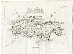
Antique Print-MARTINIQUE-CARIBBEAN-ISLAND-Bellin-Prevost-1777
Erscheinungsdatum: 1777
Anbieter: Pictura Prints, Art & Books, Overasselt, Niederlande
Verkäuferbewertung 5 von 5 Sternen
Signiert
Zustand: Very Good. Jacques Nicolas Bellin (illustrator). 'Carte de l'Isle de la Martinique (.).'Engraving / etching on hand laid (verge) paper. Sheet size: 34,5 x 25,5 cm. (13,6 x 10 inch). Image size: 29,5 x 19,5 cm. (11,6 x 7,7 inch).From a Dutch edition of Prevost's monumental work: 'Historische Beschryving der Reizen [.]', published in Amsterdam by E. van Harrevelt and d. J. Changuion, 1777. Antoine Francois Prevost d'Exiles (or Abbe Prevost's) multi-volume 'Histoire Generale Des Voyages' (1746-1759): ultimately 17 quarto volumes recounting major voyages of discovery and descriptions of far flung parts and including around 240 maps, plans and charts of those areas. These maps, plans and charts were mostly produced by Jacques Nicolas Bellin, the influential French hydrographer. Bellin's work spans from around 1740 to the 1770s; interestingly he signed his plates in a variety of styles: J. Bellin, N. Bellin, N.B., M.B. (Monsieur Bellin) and S.B. (Seigneur Bellin).Made by 'Abram van Krevelt' after 'Jacques Nicolas Bellin'. Abram van Krevelt (1732-1784) was a Dutch draughtsman and engraver. Antoine Francois Prevost d'Exiles (1697-1763), usually known simply as the Abbe Prevost, was a French author and novelist.Condition: Very good, given age. Original vertical folds as issued. General age-related toning and/or occasional minor defects from handling. Please study scan carefully.Keywords: MARTINIQUE-CARIBBEAN-ISLANDPCO-A29-03.
-
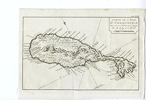
Antique Print-SAINT KITTS-CHRISTOPHER-CARIBBEAN-Prevost-Bellin-1777
Erscheinungsdatum: 1777
Anbieter: Pictura Prints, Art & Books, Overasselt, Niederlande
Verkäuferbewertung 5 von 5 Sternen
Signiert
Zustand: Very Good. Jacques Nicolas Bellin (illustrator). 'Carte de l'Isle St. Christophle (.).'Engraving / etching on hand laid (verge) paper. Sheet size: 33 x 25,5 cm. (13 x 10 inch). Image size: 30,5 x 24 cm. (12 x 9,4 inch).From a Dutch edition of Prevost's monumental work: 'Historische Beschryving der Reizen [.]', published in Amsterdam by E. van Harrevelt and d. J. Changuion, 1777. Antoine Francois Prevost d'Exiles (or Abbe Prevost's) multi-volume 'Histoire Generale Des Voyages' (1746-1759): ultimately 17 quarto volumes recounting major voyages of discovery and descriptions of far flung parts and including around 240 maps, plans and charts of those areas. These maps, plans and charts were mostly produced by Jacques Nicolas Bellin, the influential French hydrographer. Bellin's work spans from around 1740 to the 1770s; interestingly he signed his plates in a variety of styles: J. Bellin, N. Bellin, N.B., M.B. (Monsieur Bellin) and S.B. (Seigneur Bellin).Made by 'Abram van Krevelt' after 'Jacques Nicolas Bellin'. Abram van Krevelt (1732-1784) was a Dutch draughtsman and engraver. Antoine Francois Prevost d'Exiles (1697-1763), usually known simply as the Abbe Prevost, was a French author and novelist.Condition: Very good, given age. Original folds as issued. General age-related toning and/or occasional minor defects from handling. Please study scan carefully.Keywords: SAINT KITTS-CHRISTOPHER-CARIBBEANPCO-A29-07.
-
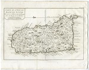
Antique Print-SAINT LUCIA-CARIBBEAN-Bellin-Prevost-1777
Erscheinungsdatum: 1777
Anbieter: Pictura Prints, Art & Books, Overasselt, Niederlande
Verkäuferbewertung 5 von 5 Sternen
Signiert
Zustand: Very Good. Jacques Nicolas Bellin (illustrator). 'Carte de l'Isle de Sainte Lucie (.).'Engraving / etching on hand laid (verge) paper. Sheet size: 32,5 x 25,5 cm. (12,8 x 10 inch). Image size: 29,8 x 19,5 cm. (11,7 x 7,7 inch).From a Dutch edition of Prevost's monumental work: 'Historische Beschryving der Reizen [.]', published in Amsterdam by E. van Harrevelt and d. J. Changuion, 1777. Antoine Francois Prevost d'Exiles (or Abbe Prevost's) multi-volume 'Histoire Generale Des Voyages' (1746-1759): ultimately 17 quarto volumes recounting major voyages of discovery and descriptions of far flung parts and including around 240 maps, plans and charts of those areas. These maps, plans and charts were mostly produced by Jacques Nicolas Bellin, the influential French hydrographer. Bellin's work spans from around 1740 to the 1770s; interestingly he signed his plates in a variety of styles: J. Bellin, N. Bellin, N.B., M.B. (Monsieur Bellin) and S.B. (Seigneur Bellin).Made by 'Abram van Krevelt' after 'Jacques Nicolas Bellin'. Abram van Krevelt (1732-1784) was a Dutch draughtsman and engraver. Antoine Francois Prevost d'Exiles (1697-1763), usually known simply as the Abbe Prevost, was a French author and novelist.Condition: Very good, given age. Original vertical folds as issued. General age-related toning and/or occasional minor defects from handling. Please study scan carefully.Keywords: SAINT LUCIA-CARIBBEAN-SAINTE LUCIEPCO-A29-04.
-
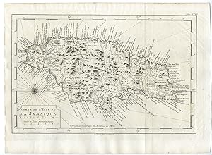
Antique Print-JAMAICA-JAMAIQUE-CARIBBEAN-Bellin-Prevost-1777
Erscheinungsdatum: 1777
Anbieter: Pictura Prints, Art & Books, Overasselt, Niederlande
Verkäuferbewertung 5 von 5 Sternen
Signiert
Zustand: Very Good. Jacques Nicolas Bellin (illustrator). 'Carte de l'Isle de Jamaique (.).'Engraving / etching on hand laid (verge) paper. Sheet size: 35 x 25,5 cm. (13,8 x 10 inch). Image size: 31,4 x 20,3 cm. (12,4 x 8 inch).From a Dutch edition of Prevost's monumental work: 'Historische Beschryving der Reizen [.]', published in Amsterdam by E. van Harrevelt and d. J. Changuion, 1777. Antoine Francois Prevost d'Exiles (or Abbe Prevost's) multi-volume 'Histoire Generale Des Voyages' (1746-1759): ultimately 17 quarto volumes recounting major voyages of discovery and descriptions of far flung parts and including around 240 maps, plans and charts of those areas. These maps, plans and charts were mostly produced by Jacques Nicolas Bellin, the influential French hydrographer. Bellin's work spans from around 1740 to the 1770s; interestingly he signed his plates in a variety of styles: J. Bellin, N. Bellin, N.B., M.B. (Monsieur Bellin) and S.B. (Seigneur Bellin).Made by 'Abram van Krevelt' after 'Jacques Nicolas Bellin'. Abram van Krevelt (1732-1784) was a Dutch draughtsman and engraver. Antoine Francois Prevost d'Exiles (1697-1763), usually known simply as the Abbe Prevost, was a French author and novelist.Condition: Very good, given age. Original vertical folds as issued. General age-related toning and/or occasional minor defects from handling. Please study scan carefully.Keywords: JAMAICA-JAMAIQUE-CARIBBEANPCO-A29-04.
-
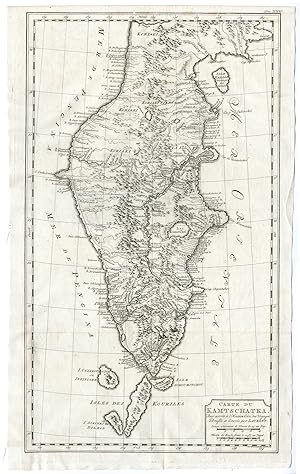
Antique Print-KAMCHATKA PENINSULA-RUSSIA-van Krevelt-Prevost-1777
Erscheinungsdatum: 1777
Anbieter: Pictura Prints, Art & Books, Overasselt, Niederlande
Verkäuferbewertung 5 von 5 Sternen
Signiert
Zustand: Very Good. Anonymous (illustrator). 'Carte du Kamtschatka (.).'Engraving / etching on hand laid (verge) paper. Sheet size: 32,5 x 54 cm. (12,8 x 21,3 inch). Image size: 29,5 x 51 cm. (11,6 x 20,1 inch).From a Dutch edition of Prevost's monumental work: 'Historische Beschryving der Reizen [.]', published in Amsterdam by E. van Harrevelt and d. J. Changuion, 1777. Antoine Francois Prevost d'Exiles (or Abbe Prevost's) multi-volume 'Histoire Generale Des Voyages' (1746-1759): ultimately 17 quarto volumes recounting major voyages of discovery and descriptions of far flung parts and including around 240 maps, plans and charts of those areas. These maps, plans and charts were mostly produced by Jacques Nicolas Bellin, the influential French hydrographer. Bellin's work spans from around 1740 to the 1770s; interestingly he signed his plates in a variety of styles: J. Bellin, N. Bellin, N.B., M.B. (Monsieur Bellin) and S.B. (Seigneur Bellin).Made by 'Abram van Krevelt' after 'Anonymous'. Abram van Krevelt (1732-1784) was a Dutch draughtsman and engraver. Antoine Francois Prevost d'Exiles (1697-1763), usually known simply as the Abbe Prevost, was a French author and novelist.Condition: Very good, given age. Original folds as issued. General age-related toning and/or occasional minor defects from handling. Please study scan carefully.Keywords: KAMCHATKA PENINSULA-RUSSIAPCO-A29-12.
-
Universele of Waereld-kaart volgens de laatste ontdekkingen van cap. Cook.
Anbieter: Rob Kok Old Books & Prints, Loosdrecht, NH, Niederlande
Verkäuferbewertung 4 von 5 Sternen
1786. Handcoloured map. 205 x 24 cm. Folded. With small hole in the marge. Taken from: Compleete zak-atlas van de zeventien Nederlandsche Provinciën. Amsteldam, Elwe en Langeveld, 17 [100390].

![Bild des Verkäufers für Compleete Zak-Atlas, van der Zeventien Nederlandsche Provincien, begreepen in XXXI, zeer naauwkeurig en zindfelyk in [Text in Unknown]t koper gebragte Kaarten, Op nieuw vervaardigd, nar bde laatste verbeteringen. . van de Heeren, Fraex, Bachine, und andere voornaame Aardryks-Kundigen: Waar by gevoegd is, een Algemeen denkbeeld van de Aardryks-kunde, Benevens eene korte beschtyving der XVII Nederlandsche Provincien . zum Verkauf von Maggs Bros. Ltd ABA, ILAB, PBFA](https://pictures.abebooks.com/inventory/md/md30447189964.jpg)