Gesamtpreis (1 Artikel Artikel):
Versandziel:

jeffreys thomas (13 Ergebnisse)
Direkt zu den wichtigsten Suchergebnissen
Suchfilter
Produktart
- Alle Product Types
- Bücher (8)
- Magazine & Zeitschriften (Keine weiteren Ergebnisse entsprechen dieser Verfeinerung)
- Comics (Keine weiteren Ergebnisse entsprechen dieser Verfeinerung)
- Noten (Keine weiteren Ergebnisse entsprechen dieser Verfeinerung)
- Kunst, Grafik & Poster (1)
- Fotografien (Keine weiteren Ergebnisse entsprechen dieser Verfeinerung)
- Karten (3)
- Manuskripte & Papierantiquitäten (1)
Zustand Mehr dazu
- Neu (Keine weiteren Ergebnisse entsprechen dieser Verfeinerung)
- Wie Neu, Sehr Gut oder Gut Bis Sehr Gut (Keine weiteren Ergebnisse entsprechen dieser Verfeinerung)
- Gut oder Befriedigend (2)
- Ausreichend oder Schlecht (1)
- Wie beschrieben (10)
Einband
Weitere Eigenschaften
Sprache (3)
Preis
- Beliebiger Preis
- Weniger als EUR 20 (Keine weiteren Ergebnisse entsprechen dieser Verfeinerung)
- EUR 20 bis EUR 45
- Mehr als EUR 45
Gratisversand
Land des Verkäufers
Verkäuferbewertung
-
2nd edition. Near fine cloth copy in a near-fine, very slightly edge-nicked and dust-dulled dust wrapper, now mylar-sleeved. Remains particularly well-preserved overall; tight, bright, clean and strong. Subjects: Great Britain Laws, statutes. Collections. 3 Kg.
-

Disorders of the Cervical Spine
Anbieter: Majestic Books, Hounslow, Vereinigtes Königreich
Verkäuferbewertung 4 von 5 Sternen

EUR 57,25
EUR 7,53 Versand
Versand von Vereinigtes Königreich nach USAAnzahl: 1 verfügbar
In den WarenkorbZustand: Used. pp. 240 Illus.
-
Disorders of the Cervical Spine
Anbieter: Biblios, Frankfurt am main, HESSE, Deutschland
Verkäuferbewertung 4 von 5 Sternen
Zustand: Used. pp. 240.
-
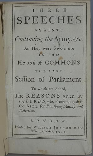
Three Speeches Against Continuing the Army, &c. As They Were Spoken in the house of Commons the Last Session of Parliament. To Which are Added, the Reasons Given by the Lords, Who Protested Against the Bill for Punishing Mutiny and Desertion
Verlag: William Johnson, London, 1718
Anbieter: Besleys Books PBFA, Diss, Vereinigtes Königreich
Verbandsmitglied: PBFA
Verkäuferbewertung 5 von 5 Sternen

EUR 35,77
EUR 20,84 Versand
Versand von Vereinigtes Königreich nach USAAnzahl: 1 verfügbar
In den WarenkorbSoft Cover. Zustand: Good. Booklet, disbound, modern paper wraps. 46pp. Occasional small soiling. Scarce. (a0).
-

Yorkshire Map: By Jefferys
Anbieter: Optimon Books, Gravesend, KENT, Vereinigtes Königreich
Verkäuferbewertung 5 von 5 Sternen
EUR 106,12
EUR 17,37 Versand
Versand von Vereinigtes Königreich nach USAAnzahl: 1 verfügbar
In den WarenkorbPaperback. Zustand: Fair. THERE ARE NO TARIFFS OR CUSTOMS DUTIES ON BOOKS. This facsimile reprint of Jeffreys' map is published at a scale of 1 inch to 1 mile in 20 sheets plus a cover sheet and a 2 sheet introduction by Brian Harley of Exeter University.Each sheet is 24.5" x 26.5". When assembled the full size map is 115 inches wide by 92 inches high. The sheets have Nottingham College of Education, Geography Department, stamped on rear.Some creases and tears to edges. Small stain on sheets 2 and 3. Overall in good condition. Protected by pale blue paper covers, which have tears to edges.Thomas Jefferys (c. 1719 â?" 1771), "Geographer to King George III", was an English cartographer who was the leading map supplier of his day. He engraved and printed maps for government and other official bodies and produced a wide range of commercial maps and atlases. Will be sent by courier.
-

THE PORT OF CALLAO, IN THE SOUTH SEA; WITH THE ADJACENT ISLANDS, ROCKS & COASTS
Verlag: c. 1760, 1760
Anbieter: Second Story Books, ABAA, Rockville, MD, USA
Verkäuferbewertung 4 von 5 Sternen
Karte
A map of the Peruvian port city of Callao, prepared by the English cartographer Thomas Jeffreys (c. 1719-1771), who was the geographer to George III. This map was originally published in a magazine, which has resulted in several folds (none of which show significant evidence of wear). Light age toning and some surface soiling in the left hand margin. Matted and framed, not examined out of frame. Map dimesions 14.5" x 8.5". Framed dimensions w 20 in x h 14 in. Shelved at Rockville PS1101 (#19). 1328558. Special Collections - Upstairs.
-
![Bild des Verkäufers für [Three Tory Statesmen, 1793.] Autograph Signatures of 'Mornington' [Marquis Wellesley, Wellington's brother], 'Bayham' [Marquis Camden, Ireland connection] and 'J. Th. Townshend' [Viscount Sydney of St Leonards], on part of parliamentary document. zum Verkauf von Richard M. Ford Ltd](https://pictures.abebooks.com/inventory/md/md31703296002.jpg)
[Three Tory Statesmen, 1793.] Autograph Signatures of 'Mornington' [Marquis Wellesley, Wellington's brother], 'Bayham' [Marquis Camden, Ireland connection] and 'J. Th. Townshend' [Viscount Sydney of St Leonards], on part of parliamentary document.
Verlag: Dated at foot 'July ', 1793
Anbieter: Richard M. Ford Ltd, London, Vereinigtes Königreich
Verkäuferbewertung 5 von 5 Sternen
Manuskript / Papierantiquität
EUR 214,64
EUR 5,21 Versand
Versand von Vereinigtes Königreich nach USAAnzahl: 1 verfügbar
In den WarenkorbRichard Colley Wellesley (1760-1842), 1st Marquess Wellesley [as Earl of Mornington]; John Jeffreys Pratt (1759-1840), 1st Marquess Camden [as Viscount Bayham]; John Thomas Townshend (1764-1831), 2nd Viscount Sydney of St Leonards. See their entries in the Oxford DNB. On 5.5 x 15.5 cm strip extracted from a document, and laid down on 8 x 21.5 cm part of gilt-edged leaf from an album. In good condition, lightly aged on aged and creased mount. The signatures are written above one another: 'Mornington / Bayham / J. Th. Townshend'. The only other writing, at the foot of the strip is ' / July 1793'. "Camden served as Lord Lieutenant of Ireland in the revolutionary years 1795 to 1798 and as Secretary of State for War and the Colonies between 1804 and 1805.".
-
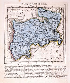
A Map of Middlesex.
Verlag: London, Robert Sayer, John Bennett, John & Carrington Bowles, 1775. 175 x 145mm (7 x 5ľ inches)., 1775
Anbieter: Tooley, Adams & Co., Wallingford, OXON, Vereinigtes Königreich
Verkäuferbewertung 4 von 5 Sternen
EUR 69,16
EUR 43,01 Versand
Versand von Vereinigtes Königreich nach USAAnzahl: 1 verfügbar
In den WarenkorbOriginal colour; very minor spotting in the margins, otherwise a fine example. A map of the county from, 'The Small English Atlas'.
-
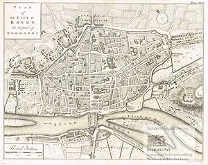
Plan of the City of Rouen the Capital of Normandy. Antique Map. Stadtplan von Rouen in der Normandie an der Seine. Original-Kupferstich von Thomas Jeffreys um 1770
Sprache: Deutsch
Verlag: London: John Cary um, 1815
Anbieter: historicArt Antiquariat & Kunsthandlung, Wiesbaden-Breckenheim, Deutschland
Verkäuferbewertung 5 von 5 Sternen
Karte Erstausgabe Signiert
1. detailreicher Original-Kupferstich von Thomas Jeffreys (in der Platte signiert) auf rückseitig unbedrucktem Büttenkarton, bildliche Darstellung ca. 20 x 25,5 cm, mit dekorativ abgesetztem Plattenrand, Blattgröße ca. 24,5 x 33 cm, rückseitig Namenseintrag des Vorbesitzers in Tinte, kleiner Einriss oben in der geglätteten Mittelfalz, im unteren breiten Rand etwas angestaubt, ansonsten sehr schöner und prägnantes Blatt aus dem Werk "A Description of the Maritime Parts of France" großer und/oder schwerer Artikel mit zusätzlichen Kosten für Versand und Versicherung - heavy and/or oversized item with additional costs for shipping and insurance - please ask us before you order this article 2100 gr.
-

Three Speeches Against Continuing the Army, &c. As They were Spoken In The House of Commons The Last Session of Parliament, To which are Added, The Reasons given by the Lords, who Protested against the Bill for Punishing Mutiny and Desertion.
Verlag: London: Printed for John Morphew, 1718., 1718
Anbieter: D & E LAKE LTD. (ABAC/ILAB), Toronto, ON, Kanada
Verkäuferbewertung 3 von 5 Sternen

Erstausgabe
8vo. pp. 46. disbound. First Edition.
-
A Chart opf the Gulf of St. Laurence, Composed from a Great Number of Actual Surveys and other Materials, Regulated and Connected by Astronomical Observations.
Verlag: Sayer & Bennett, London, 1775
Anbieter: Alexandre Antique Prints, Maps & Books, Toronto, ON, Kanada
Verkäuferbewertung 5 von 5 Sternen
Karte
Zustand: Very Good. This is the first state of the map (according to Kershaw), published in "The American Atlas."An impressive nautical chart depicting the Gulf of the St. Lawrence. Depth soundings have been noted along most of the coastlines. A small table denotes place names and their associated longitude and latitude sits in the top of the image., Size : 365x512 (mm), 14.37x20.16 (Inches), Hand Colored, 0.
-
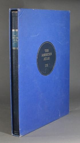
The American atlas 1776
Verlag: Times Newspapers Limited in association with the Royal Geographic Society and David Paradine Developments Limited, London, 1976
Anbieter: Rulon-Miller Books (ABAA / ILAB), St. Paul, MN, USA
Verbandsmitglied: ABAA ILAB RMABA
Verkäuferbewertung 5 von 5 Sternen
Limited to 200 copies (this, no. 16), large folio, pp. [8] plus 30 hand-colored maps, all but 1 either folding or double-page; original half blue morocco over blue marbled paper-covered boards, blue morocco label lettered in gilt on upper cover; publisher's slipcase; very light wear else near fine throughout. Originally published in London, and printed and sold by R. Sayer and J. Bennett, 1776.
-

Amsterdam - Thomas Jeffreys, c
Anbieter: Inter-Antiquariaat Mefferdt & De Jonge, Amsterdam, Niederlande
Verkäuferbewertung 4 von 5 Sternen
Kunst / Grafik / Poster
"A View of Amsterdam", ets vervaardigd door Thomas Jeffreys rond 1750, later met de hand gekleurd. Afm. 17,5 x 39,5 cm. We zien de stad vanaf een fictief punt, ongeveer 20 meter boven de Amstel, richting de Hogesluis. Ten zuiden van de huidige Sarphatistraat-Stadhouderskade was de omgeving van Amsterdam zeer landelijk. Er waren tuinen met soms een klein huisje erin, later bouwden rijke Amsterdammers aan de westelijke Amsteloever tientallen buitenplaatsen. Links van de rivier op de Amsteldijk, herberg de Berebijt. De naam ontleende het etablissement aan de berengevechten die hier in de 17de eeuw werden gehouden. Hiervandaan vertrokken de trekschuiten naar Utrecht; voor de trekschuit naar Muiden en Weesp moest men aan de overkant zijn, bij uitspanningen Lokhorst en De IJsbreker op de Weesperzijde. Onder de voorstelling een uitgebreide legenda met publieke gebrouwen en bastions. Prijs: Euro 495,-.