
Gesamtpreis (1 Artikel Artikel):
Versandziel:

intelligence office arab bureau (4 Ergebnisse)
Direkt zu den wichtigsten Suchergebnissen
Suchfilter
Produktart
- Alle Product Types
- Bücher (2)
- Magazine & Zeitschriften (Keine weiteren Ergebnisse entsprechen dieser Verfeinerung)
- Comics (Keine weiteren Ergebnisse entsprechen dieser Verfeinerung)
- Noten (Keine weiteren Ergebnisse entsprechen dieser Verfeinerung)
- Kunst, Grafik & Poster (Keine weiteren Ergebnisse entsprechen dieser Verfeinerung)
- Fotografien (Keine weiteren Ergebnisse entsprechen dieser Verfeinerung)
- Karten (2)
- Manuskripte & Papierantiquitäten (Keine weiteren Ergebnisse entsprechen dieser Verfeinerung)
Zustand Mehr dazu
- Neu (Keine weiteren Ergebnisse entsprechen dieser Verfeinerung)
- Wie Neu, Sehr Gut oder Gut Bis Sehr Gut (Keine weiteren Ergebnisse entsprechen dieser Verfeinerung)
- Gut oder Befriedigend (Keine weiteren Ergebnisse entsprechen dieser Verfeinerung)
- Ausreichend oder Schlecht (Keine weiteren Ergebnisse entsprechen dieser Verfeinerung)
- Wie beschrieben (4)
Einband
- alle Einbände
- Hardcover (2)
- Softcover (Keine weiteren Ergebnisse entsprechen dieser Verfeinerung)
Weitere Eigenschaften
- Erstausgabe (1)
- Signiert (Keine weiteren Ergebnisse entsprechen dieser Verfeinerung)
- Schutzumschlag (Keine weiteren Ergebnisse entsprechen dieser Verfeinerung)
- Angebotsfoto (4)
Sprache (1)
Preis
- Beliebiger Preis
- Weniger als EUR 20 (Keine weiteren Ergebnisse entsprechen dieser Verfeinerung)
- EUR 20 bis EUR 45 (Keine weiteren Ergebnisse entsprechen dieser Verfeinerung)
- Mehr als EUR 45
Gratisversand
- Kostenloser Versand nach USA (Keine weiteren Ergebnisse entsprechen dieser Verfeinerung)
Land des Verkäufers
Verkäuferbewertung
-
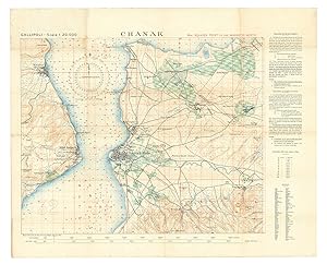
Chanak.
Verlag: Survey Department Egypt,, Cairo,, 1915
Anbieter: Antiquariaat FORUM BV, Houten, Niederlande
Verkäuferbewertung 5 von 5 Sternen

EUR 3.500,00
EUR 25,00 Versand
Versand von Niederlande nach USAAnzahl: 1 verfügbar
In den WarenkorbThe finest contemporary map of the Çanakkale sector of the Gallipoli Campaign, the site of the dreaded "Narrows" of the Dardanelles where allied naval forces made their ill-fated attempt to "force the straits" towards taking Istanbul, at a scale of 1:20,000. Drafted in Cairo under the direction of T. E. Lawrence (Lawrence of Arabia) at the Arab Bureau's Intelligence Office, based on a recently captured Ottoman map. The main map image is in black with land contours in brown, waterways in blue, and vegetation in green, with soundings printed in the strait and a grid of parallels and meridians in red (with a note that they are based on a magnetic north). The larger squares (each 5 x 5 smaller squares) are numbered (in a single sequence for the six maps in the series) and the 25 smaller squares designated by letters a-z (without e) - printed only in square 33, so that any 600 x 600 metre square on the map can be specified with coordinates.In the early days of World War I, the British and allied forces sought to knock the Ottoman Empire out of the conflict by taking Constantinople, by way of the Dardanelles. The Gallipoli Campaign (17 February 1915 to 9 January 1916) involved a force of 490,000 British, Indian, Australian, New Zealander and French troops making various landings upon the Gallipoli Peninsula that strategically guarded the mouth of the Dardanelles. The 325,000 Ottoman defenders, backed by German forces, successfully repelled these raids in one of the bloodiest military conflicts in world history.From the outset, the Allies were hampered by a lack of accurate maps of the Gallipoli Peninsula and the adjacent Asian shore of the Dardanelles. They eventually succeeded in capturing a complete six-part set of excellent, newly published Ottoman surveys showing the battle theatre in its entirety. These maps were rushed to the map department of the Intelligence Office (later the famed "Arab Bureau") in Cairo, where they were translated, enlarged and improved by a team headed by Lieutenant T. E. Lawrence, later known as "Lawrence of Arabia". These maps were printed by the Survey Department, Egypt, as a series of six interconnecting maps, although each map was designed to act as a stand-alone work complete in and of itself (a geographic key to all six maps is present on the back of the present map).Overall clean and bright, with some very light stains in the upper-left quadrant and light wear at some fold vertices.l Not in WorldCat. Folded. Colour-lithographed map (79 x 62.5 cm), printed in black, brown, red, blue and green. Mounted on contemporary cloth, with the key on the back (printed on or printed and pasted onto).
-

Colour lithograph, 790 x 625 mm. Mounted on original cloth with maps series key printed on verso. Folded. The finest contemporary map of the Çanakkale sector of the Gallipoli Campaign, the site of the dreaded "Narrows" of the Dardanelles where Allied naval forces made their ill-fated attempt to "force the straits" towards taking Istanbul. Drafted in Cairo under the direction of T. E. Lawrence at the Arab Bureau's Intelligence Office, based on a recently captured Ottoman map. - In the early days of World War I, the Entente sought to knock the Ottoman Empire out of the conflict by taking Constantinople, by way of the Dardanelles. The Gallipoli Campaign (17 February 1915 to 9 January 1916) involved a force of 490,000 British, Indian, Australian, New Zealander and French troops making various landings upon the Gallipoli Peninsula that strategically guarded the mouth of the Dardanelles. The 325,000 Ottoman defenders, backed by German forces, successfully repelled these raids in what was one of the most bloody military contests in world history. - From the outset, the Allies were hampered by a lack of accurate maps of the Gallipoli Peninsula and the adjacent Asian shore of the Dardanelles. They eventually succeeded in capturing a complete six-part set of excellent, newly published Ottoman surveys showing the battle theatre in its entirety. These maps were rushed to the map department of the Intelligence Office (later the famed "Arab Bureau") in Cairo, where they were translated, enlarged and improved by a team headed by Lieutenant T. E. Lawrence, later known as "Lawrence of Arabia". These maps were printed by the Survey Department, Egypt, as a series of six interconnecting maps, although each map was designed to act as a stand-alone work complete in and of itself (a geographic key to all six maps is present on the verso of the present map). - Overall clean and bright, with some very light staining to upper-left quadrant and some light wear at some fold vertices.
-
[Maps of the Gallipoli Peninsula.]
Erscheinungsdatum: 1915
Anbieter: Maggs Bros. Ltd ABA, ILAB, PBFA, London, Vereinigtes Königreich
Verbandsmitglied: ABA ILAB PBFA
Verkäuferbewertung 5 von 5 Sternen
Karte
EUR 8.954,33
EUR 31,30 Versand
Versand von Vereinigtes Königreich nach USAAnzahl: 1 verfügbar
In den WarenkorbFirst editions, first issues. Six colour lithograph maps measuring 630 by 785mm or 490 by 880mm. Scale 1 : 20,000. Very good copies mounted on linen with pin-holes from hanging, folded with a little staining. Cairo, Survey Department, Rare and important: a complete set of maps of the Gallipoli Peninsula produced under the direction of T.E. Lawrence in Cairo and based on captured Ottoman maps. In June 1915, working on the basis of a partial set of maps found on a captured Turkish soldier, T.E. Lawrence?s Arab Bureau produced this series of six maps, each separately mapping the entire length of the Gallipoli Peninsula in a format designed to be issued to officers fighting in the field. The maps are as follows: Kurija Dere; Bogali; Anarfarta Saghir; Chanak; Krithia; and Damler. Of these, Kurija Dere (now Kocadere) is the most important, being an advanced topographical rendering of the Ari Burnu sector (named after the sea point located in the centre of the map), in the north-western part of the Gallipoli Peninsula. It was issued in the summer of 1915 while the Gallipoli campaign was still ongoing. It adds the toponyms Anzac Cove, Brighton Beach, Hell Spit, and Maclagan?s Ridge, while noting the critical battles of August, 1915: Lone Pine and Chunuk Bair. The maps provide a clear understanding of the extreme difficulty that both the ANZACs and the Ottoman defenders faced while operating in such rugged territory. Soldiers often had to climb slopes of over 45° in gradient while enduring enemy fire. A series of red numbered grids, all orientated to the magnetic north to aid the use of the map in the field, have been added as Allied troops previously encountered severe orientation problems using the old maps of Gallipoli. The text panel to the right of the maps explains, in both English and French, how to use the grid reference as well as providing chart for converting feet to metres. A ?reference? translates Turkish topographical terms into English. In the event that they were captured, the importance of these maps were such that officers were generally given only the sector relevant for them. While the campaign was vital to the history of both Australia and New Zealand, it also made the name of Ottoman Colonel Mustafa Kemal, better known as ?Atatürk.? The Gallipoli Campaign ran from 17 February, 1915 to 9 January, 1916 and involved a force of 490,000 Allied soldiers (British, Indian, Australian, New Zealand, and French troops) who were deployed in a series of landings along the Gallipoli Peninsula which was defended by 325,000 Ottoman troops. The Allies were hampered by misguided assumptions regarding the strength of Turkish forces, as well as poor geographic intelligence, notably relying on an Admiralty chart published in 1908 which was both inaccurate and at an unhelpful scale of 1 : 50,000, as well as a French map dating from the Crimean War. While individual maps appear on the market from time to time, complete sets are very rare indeed. Brought together, they clarify the impossible demands of the entire campaign. Oral, H., Gallipoli through Turkish Eyes (Istanbul, Bahçesehir University Press, 2012), pp.219-37. .
-
Turkey. Gallipoli.
Erscheinungsdatum: 1915
Anbieter: Maggs Bros. Ltd ABA, ILAB, PBFA, London, Vereinigtes Königreich
Verbandsmitglied: ABA ILAB PBFA
Verkäuferbewertung 5 von 5 Sternen
Karte Erstausgabe
EUR 2.984,78
EUR 31,30 Versand
Versand von Vereinigtes Königreich nach USAAnzahl: 1 verfügbar
In den WarenkorbFirst edition. Colour-printed map, measuring 505 by 675mm. Scale 1 : 250,000. Dissected and then backed on original linen, folded for use, ms. ink annotations. Cairo, Survey Department, A wonderful copy of this remarkable map of Gallipoli belonging to Lt. Eric Arundel Wilton dso, Signalling Officer of the 16th Battalion. Wilton went ashore on the first day of the landings and was invalided off the peninsula with a serious gunshot wound a week later. The map was originally produced by the British War Office in October 1908 (as is noted on the map itself) but this is the first wartime issue, specifically produced in Cairo for the use of the forces ashore at Gallipoli in 1915 by the map-making group headed by T.E. Lawrence. There was later a second issue, easily identified by the addition ?corrected to July 1915,? just before the major series of secondary landings in August. This is a medium-format map on a 1:250,000 scale, perhaps less well-known than the series of 1:20,000 maps of specific sites. The scale allows the map to take in the entire peninsula, from the landing sites on the western coast right across the peninsula to the dreamt-of destination at Gallipoli itself. In addition to topographical information it denotes vegetation, water features, natural landmarks, populated places, and transport routes. The map has the ownership inscription of Wilton (1892?1932), a Victorian who enlisted into the AIF straight from the new Royal Military College at Duntroon, where he had been part of the first intake of June 1911. He was immediately appointed as a Lieutenant and Signalling Officer in the 16th Battalion, landing at Gallipoli on the first day. He was reported badly wounded on 1 May, although some sources, notably the account of the battle by the artist Ellis Silas (also a signaller in the 16th), suggest he had actually been carrying the wound for days. Given that Wilton was wounded and evacuated from Gallipoli within a week of the landing, never to return, the inference must be that this is the map issued to him as Signalling Officer for the landing: this would accord with the physical evidence on the verso, his name and ?copy no. 27? being added in ink ? clearly the map was only given out under very strict controls. Below these notes has been added a stamp for the ?4th Infantry Brigade? dated May 29, 1915 (perhaps it was in some sense checked off by the Brigade after his evacuation given the strategic information it contains?). That he retained the map can be seen from the fact that Wilton has added his rank of ?Major? to the inscription, a rank he did not attain until he was in France. After his evacuation, Wilton received treatment in Egypt, Malta and ? most unusually ? Florence before rejoining his battalion on the Western Front. Promoted to Major and transferred to one of the new Australian Machine Gun Companies, he saw action at Pozičres in June 1916. Wounded a second time, he recuperated in England before being sent back to France in January 1917, initially with the 4th Machine Gun Company. He was promoted Brigade Major of the 4th Battalion in July, transferring to the 12th in the same role in October. His actions during Third Ypres, at Zonnebeke, in January 1918 led to him being awarded the Distinguished Service Order for his ?tenacious? work in organising the battalion?s defensive line in appalling weather while under heavy artillery fire. Twice Mentioned in Dispatches, Wilton was in a training position by the end of the war. After his return to Australia in March 1919 he was taken on the permanent staff of Duntroon as an instructor in tactics with a particular remit to study the use of mechanised vehicles. He died in a motorcycle accident in Kew in 1932. An obituary in the Melbourne papers hailed him as a ?mechanical genius.? He was buried with full military honours at Boroondara Cemetery. .
![Bild des Verkäufers für [Maps of the Gallipoli Peninsula.] zum Verkauf von Maggs Bros. Ltd ABA, ILAB, PBFA](https://pictures.abebooks.com/inventory/md/md32265424689.jpg)
