
Gesamtpreis (1 Artikel Artikel):
Versandziel:

india office (450 Ergebnisse)
Direkt zu den wichtigsten Suchergebnissen
Suchfilter
Produktart
- Alle Product Types
- Bücher (448)
- Magazine & Zeitschriften (Keine weiteren Ergebnisse entsprechen dieser Verfeinerung)
- Comics (Keine weiteren Ergebnisse entsprechen dieser Verfeinerung)
- Noten (Keine weiteren Ergebnisse entsprechen dieser Verfeinerung)
- Kunst, Grafik & Poster (Keine weiteren Ergebnisse entsprechen dieser Verfeinerung)
- Fotografien (Keine weiteren Ergebnisse entsprechen dieser Verfeinerung)
- Karten (1)
- Manuskripte & Papierantiquitäten (1)
Zustand Mehr dazu
Weitere Eigenschaften
Sprache (3)
Gratisversand
Land des Verkäufers
Verkäuferbewertung
-
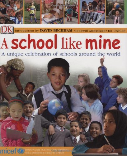
A School Like Mine : A Unique Celebration of Schools Around the World
Sprache: Englisch
Verlag: Dorling Kindersley Publishing, Incorporated, 2007
ISBN 10: 0756629136 ISBN 13: 9780756629137
Anbieter: Better World Books, Mishawaka, IN, USA
Verkäuferbewertung 5 von 5 Sternen

Zustand: Very Good. Former library copy. Pages intact with possible writing/highlighting. Binding strong with minor wear. Dust jackets/supplements may not be included. Includes library markings. Stock photo provided. Product includes identifying sticker. Better World Books: Buy Books. Do Good.
-
A School Like Mine : A Unique Celebration of Schools Around the World
Sprache: Englisch
Verlag: Dorling Kindersley Publishing, Incorporated, 2007
ISBN 10: 0756629136 ISBN 13: 9780756629137
Anbieter: Better World Books, Mishawaka, IN, USA
Verkäuferbewertung 5 von 5 Sternen
Zustand: Good. Former library copy. Pages intact with minimal writing/highlighting. The binding may be loose and creased. Dust jackets/supplements are not included. Includes library markings. Stock photo provided. Product includes identifying sticker. Better World Books: Buy Books. Do Good.
-

East India (Fifty Years Administration) : Memorandum on Some of the Results of Indian Administration During the Past Fifty Years of British Rule in India : Presented to Both Houses of Parliament by Command of His Majesty
Anbieter: PBShop.store US, Wood Dale, IL, USA
Verkäuferbewertung 5 von 5 Sternen
PAP. Zustand: New. New Book. Shipped from UK. Established seller since 2000.
-

Yarkand Forsyth's Mission
Anbieter: PBShop.store US, Wood Dale, IL, USA
Verkäuferbewertung 5 von 5 Sternen
PAP. Zustand: New. New Book. Shipped from UK. Established seller since 2000.
-

East India (Wheat); Reports and Papers on Impurities in Indian Wheats, 1888-89
Anbieter: PBShop.store US, Wood Dale, IL, USA
Verkäuferbewertung 5 von 5 Sternen
PAP. Zustand: New. New Book. Shipped from UK. Established seller since 2000.
-

Pamphlets issued by the India office and by other British and Indian governmental agencies, relating to the government of India, and to various political, economic, and social questions concerning it and Burma.
Anbieter: PBShop.store US, Wood Dale, IL, USA
Verkäuferbewertung 5 von 5 Sternen
PAP. Zustand: New. New Book. Shipped from UK. Established seller since 2000.
-
East India Fifty Years Administration Memorandum on Some of the Results of Indian Administration During the Past Fifty Years of British Rule in Ind
Anbieter: PBShop.store UK, Fairford, GLOS, Vereinigtes Königreich
Verkäuferbewertung 4 von 5 Sternen

EUR 15,41
EUR 3,80 Versand
Versand von Vereinigtes Königreich nach USAAnzahl: 15 verfügbar
In den WarenkorbPAP. Zustand: New. New Book. Shipped from UK. Established seller since 2000.
-
East India (Wheat); Reports and Papers on Impurities in Indian Wheats, 1888-89
Anbieter: PBShop.store UK, Fairford, GLOS, Vereinigtes Königreich
Verkäuferbewertung 4 von 5 Sternen
EUR 15,41
EUR 3,80 Versand
Versand von Vereinigtes Königreich nach USAAnzahl: 15 verfügbar
In den WarenkorbPAP. Zustand: New. New Book. Shipped from UK. Established seller since 2000.
-
Pamphlets Issued by the India Office and by Other British and Indian Governmental Agencies, Relating to the Government of India, and to Various Politi
Anbieter: PBShop.store UK, Fairford, GLOS, Vereinigtes Königreich
Verkäuferbewertung 4 von 5 Sternen
EUR 15,41
EUR 3,80 Versand
Versand von Vereinigtes Königreich nach USAAnzahl: 15 verfügbar
In den WarenkorbPAP. Zustand: New. New Book. Shipped from UK. Established seller since 2000.
-
Yarkand Forsyth's Mission
Anbieter: PBShop.store UK, Fairford, GLOS, Vereinigtes Königreich
Verkäuferbewertung 4 von 5 Sternen
EUR 15,41
EUR 3,80 Versand
Versand von Vereinigtes Königreich nach USAAnzahl: 15 verfügbar
In den WarenkorbPAP. Zustand: New. New Book. Shipped from UK. Established seller since 2000.
-

East India (Constitutional Reforms): Papers Relating to Premature Retirement on Proportionate Pension (Classic Reprint)
Anbieter: PBShop.store US, Wood Dale, IL, USA
Verkäuferbewertung 5 von 5 Sternen
PAP. Zustand: New. New Book. Shipped from UK. Established seller since 2000.
-

Present Results and Future Prospects of Existing Missions in India Extracted From a Statement the Progress of India, Prepared at the India Office, Received From India Classic Reprint
Anbieter: PBShop.store US, Wood Dale, IL, USA
Verkäuferbewertung 5 von 5 Sternen
PAP. Zustand: New. New Book. Shipped from UK. Established seller since 2000.
-

The People of India : a Series of Photographic Illustrations, With Descriptive Letterpress, of the Races and Tribes of Hindustan
Anbieter: PBShop.store US, Wood Dale, IL, USA
Verkäuferbewertung 5 von 5 Sternen
PAP. Zustand: New. New Book. Shipped from UK. Established seller since 2000.
-

The People of India : a Series of Photographic Illustrations, With Descriptive Letterpress, of the Races and Tribes of Hindustan
Anbieter: PBShop.store US, Wood Dale, IL, USA
Verkäuferbewertung 5 von 5 Sternen
PAP. Zustand: New. New Book. Shipped from UK. Established seller since 2000.
-

East India Constitutional Reforms, Draft Rules Under the Government of India Act Draft Rules Under the Government of India Act Required to Give Act on 7th October 1921 by the GovernorGen
Anbieter: PBShop.store US, Wood Dale, IL, USA
Verkäuferbewertung 5 von 5 Sternen
PAP. Zustand: New. New Book. Shipped from UK. Established seller since 2000.
-

East India (Constitutional Reforms
Anbieter: PBShop.store US, Wood Dale, IL, USA
Verkäuferbewertung 5 von 5 Sternen
PAP. Zustand: New. New Book. Shipped from UK. Established seller since 2000.
-

Correspondence Between the India Office and the Royal Asiatic Society on the Subject of the Indian Texts and Records Series Together With the Minutes Certain Official Letters Classic Reprint
Anbieter: PBShop.store US, Wood Dale, IL, USA
Verkäuferbewertung 5 von 5 Sternen
PAP. Zustand: New. New Book. Shipped from UK. Established seller since 2000.
-

Indian States Protection Against Disaffection Act, 1922 Passed Under the Procedure Prescribed by Section 67b of the Government of India Act Classic Reprint
Anbieter: PBShop.store US, Wood Dale, IL, USA
Verkäuferbewertung 5 von 5 Sternen
PAP. Zustand: New. New Book. Shipped from UK. Established seller since 2000.
-

Record of Fort St. George
Anbieter: PBShop.store US, Wood Dale, IL, USA
Verkäuferbewertung 5 von 5 Sternen
PAP. Zustand: New. New Book. Shipped from UK. Established seller since 2000.
-

Reports on the Punjab Disturbances April, 1919 Classic Reprint
Anbieter: PBShop.store US, Wood Dale, IL, USA
Verkäuferbewertung 5 von 5 Sternen
PAP. Zustand: New. New Book. Shipped from UK. Established seller since 2000.
-

Catalogue of Two Collections of Sanskrit Manuscripts Preserved in the India Office Library Classic Reprint
Anbieter: PBShop.store US, Wood Dale, IL, USA
Verkäuferbewertung 5 von 5 Sternen
PAP. Zustand: New. New Book. Shipped from UK. Established seller since 2000.
-

Proposals of the Government of India for a New Constitution for Burma, Vol 1 Classic Reprint
Anbieter: PBShop.store US, Wood Dale, IL, USA
Verkäuferbewertung 5 von 5 Sternen
PAP. Zustand: New. New Book. Shipped from UK. Established seller since 2000.
-

East India Constitutional Reforms Draft Rules Under the Government of India Act, 1919, as Approved by the Joint Select Committee No 1, Draft Legislative Councils Classic Reprint
Anbieter: PBShop.store US, Wood Dale, IL, USA
Verkäuferbewertung 5 von 5 Sternen
PAP. Zustand: New. New Book. Shipped from UK. Established seller since 2000.
-

Report on Indian Constitutional Reforms
Anbieter: PBShop.store US, Wood Dale, IL, USA
Verkäuferbewertung 5 von 5 Sternen
PAP. Zustand: New. New Book. Shipped from UK. Established seller since 2000.
-

Statistical Abstract Relating to British India
Anbieter: PBShop.store US, Wood Dale, IL, USA
Verkäuferbewertung 5 von 5 Sternen
PAP. Zustand: New. New Book. Shipped from UK. Established seller since 2000.
-

The People of India : a Series of Photographic Illustrations, With Descriptive Letterpress, of the Races and Tribes of Hindustan
Anbieter: PBShop.store US, Wood Dale, IL, USA
Verkäuferbewertung 5 von 5 Sternen
PAP. Zustand: New. New Book. Shipped from UK. Established seller since 2000.
-

Calendar of the Madras Despatches, 17441755
Anbieter: PBShop.store US, Wood Dale, IL, USA
Verkäuferbewertung 5 von 5 Sternen
PAP. Zustand: New. New Book. Shipped from UK. Established seller since 2000.
-

Annual Report of the Commissioner of Indian Affairs to the Secretary of the Interior
Anbieter: PBShop.store US, Wood Dale, IL, USA
Verkäuferbewertung 5 von 5 Sternen
PAP. Zustand: New. New Book. Shipped from UK. Established seller since 2000.
-

The People of India : a Series of Photographic Illustrations, With Descriptive Letterpress, of the Races and Tribes of Hindustan
Anbieter: PBShop.store US, Wood Dale, IL, USA
Verkäuferbewertung 5 von 5 Sternen
PAP. Zustand: New. New Book. Shipped from UK. Established seller since 2000.
-

Report of the Committee Appointed by the Secretary of State for India to Enquire Into the Administration and Organisation of the Army in India Classic Reprint
Anbieter: PBShop.store US, Wood Dale, IL, USA
Verkäuferbewertung 5 von 5 Sternen
PAP. Zustand: New. New Book. Shipped from UK. Established seller since 2000.