
Gesamtpreis (1 Artikel Artikel):
Versandziel:

hermannides rutger (14 Ergebnisse)
Direkt zu den wichtigsten Suchergebnissen
Suchfilter
Produktart
- Alle Product Types
- Bücher (2)
- Magazine & Zeitschriften (Keine weiteren Ergebnisse entsprechen dieser Verfeinerung)
- Comics (Keine weiteren Ergebnisse entsprechen dieser Verfeinerung)
- Noten (Keine weiteren Ergebnisse entsprechen dieser Verfeinerung)
- Kunst, Grafik & Poster (Keine weiteren Ergebnisse entsprechen dieser Verfeinerung)
- Fotografien (Keine weiteren Ergebnisse entsprechen dieser Verfeinerung)
- Karten (12)
- Manuskripte & Papierantiquitäten (Keine weiteren Ergebnisse entsprechen dieser Verfeinerung)
Zustand Mehr dazu
- Neu (Keine weiteren Ergebnisse entsprechen dieser Verfeinerung)
- Wie Neu, Sehr Gut oder Gut Bis Sehr Gut (1)
- Gut oder Befriedigend (1)
- Ausreichend oder Schlecht (Keine weiteren Ergebnisse entsprechen dieser Verfeinerung)
- Wie beschrieben (12)
Einband
- alle Einbände
- Hardcover (Keine weiteren Ergebnisse entsprechen dieser Verfeinerung)
- Softcover (Keine weiteren Ergebnisse entsprechen dieser Verfeinerung)
Weitere Eigenschaften
- Erstausgabe (Keine weiteren Ergebnisse entsprechen dieser Verfeinerung)
- Signiert (Keine weiteren Ergebnisse entsprechen dieser Verfeinerung)
- Schutzumschlag (Keine weiteren Ergebnisse entsprechen dieser Verfeinerung)
- Angebotsfoto (14)
Sprache (2)
Preis
- Beliebiger Preis
- Weniger als EUR 20 (Keine weiteren Ergebnisse entsprechen dieser Verfeinerung)
- EUR 20 bis EUR 45 (Keine weiteren Ergebnisse entsprechen dieser Verfeinerung)
- Mehr als EUR 45
Gratisversand
- Kostenloser Versand nach USA (Keine weiteren Ergebnisse entsprechen dieser Verfeinerung)
Land des Verkäufers
Verkäuferbewertung
-
Ipswiche, Ipswich
Verlag: Amsterdam, 1661
Anbieter: Hereward Books, Ely, CAMBR, Vereinigtes Königreich
Verbandsmitglied: PBFA
Verkäuferbewertung 4 von 5 Sternen

EUR 54,11
EUR 40,86 Versand
Versand von Vereinigtes Königreich nach USAAnzahl: 1 verfügbar
In den WarenkorbNo Binding. Zustand: Very Good. 14 cm x 13 cm image size 13 cm x 11 cm.Copper engraving plan of Ipswhich in b & w as issued from Hermannides' Magna Britannia.Centre fold some light browning the map has nosplits or chips. Nearly all of the plans are based on the small inset plans shown on John Speed's county maps.
-

Oxonium. Oxford.
Verlag: Aegidius Janssonius Valckenier, 1661
Anbieter: Altea Antique Maps, London, Vereinigtes Königreich
Verbandsmitglied: ABA ILAB PBFA
Verkäuferbewertung 5 von 5 Sternen

Karte
EUR 420,83
EUR 40,86 Versand
Versand von Vereinigtes Königreich nach USAAnzahl: 1 verfügbar
In den WarenkorbNo Binding. Zustand: Fine. Amsterdam: Aegidius Janssonius Valckenier, c.1661. Coloured. 110 x 130mm. An early plan of Oxford showing the outline of the streets and churches but without naming any features. The plan was published in Hermannides's 'Magna Britannia' which contained thirty townplans mostly copied from the insets of John Speed's county maps.
-
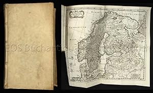
Regnorum Daniae ac Norvegiae, ut et omnium ad ea pertinentium regionum, Historica et Chorographica Descriptio. Pars I. Generalis.
Sprache: mehrsprachig
Verlag: Amsterdam, Peter le Grand, 1669
Anbieter: EOS Buchantiquariat Benz, Zürich, Schweiz
Verkäuferbewertung 4 von 5 Sternen
1. (von ?) Band. 24°. (18) Bl., 580 S. Mit figürlichem Kupfertitel und 2 gef. Karten, gest. von Aegidius Valkenier. Pergament d. Zt. mit hs. Rückentitel. Vgl. Griep/Luber 1522 (Ausgabe von Martin Zeiller, bei Janssonius Valkenier, 1655). Der vorliegende Band enthält den fast identischen Kupfertitel, jedoch mit anderer Verlagsangabe in der Kartusche unten mit dem Druckjahr 1670 in römischen Ziffern. Vermutlich gehören noch weitere Bände zu dem Werk, die vorne im Index aufgeführten Abbildungen verweisen alle auf höhere Seitenzahlen, in diesem Band befinden sich keine Abbildungen. - Karten etwas unschön gefaltet. Sprache: Deutsch / German + Wichtig: Für unsere Kunden in der EU erfolgt der Versand alle 14 Tage verzollt ab Deutschland / Postbank-Konto in Deutschland vorhanden +.
-

Dower. Douer.
Erscheinungsdatum: 1661
Anbieter: Altea Antique Maps, London, Vereinigtes Königreich
Verbandsmitglied: ABA ILAB PBFA
Verkäuferbewertung 5 von 5 Sternen
Karte
EUR 144,29
EUR 40,86 Versand
Versand von Vereinigtes Königreich nach USAAnzahl: 1 verfügbar
In den WarenkorbAmsterdam: Aegidius Janssonius Valckenier, c.1661. Coloured. 110 x 130mm. Stitch holes to left margin. A miniature map plan of Dover showing the outline of the streets and churches but without naming any features. The plan was published in Hermannides's 'Magna Britannia' which contained thirty townplans mostly copied from the insets of John Speed's county maps.
-

Staffordia. Stafford
Erscheinungsdatum: 1661
Anbieter: Altea Antique Maps, London, Vereinigtes Königreich
Verbandsmitglied: ABA ILAB PBFA
Verkäuferbewertung 5 von 5 Sternen
Karte
EUR 150,30
EUR 40,86 Versand
Versand von Vereinigtes Königreich nach USAAnzahl: 1 verfügbar
In den WarenkorbAmsterdam: Aegidius Janssonius Valckenier, c.1661. Coloured. 110 x 130mm. Stitch holes to right margin. An early miniature plan of Stafford showing the outline of the streets and churches but without naming any features. The plan was published in Hermannides's 'Magna Britannia' which contained thirty townplans mostly copied from the insets of John Speed's county maps.
-

Leicestria, Leic?ter.
Erscheinungsdatum: 1661
Anbieter: Altea Antique Maps, London, Vereinigtes Königreich
Verbandsmitglied: ABA ILAB PBFA
Verkäuferbewertung 5 von 5 Sternen
Karte
EUR 156,31
EUR 40,86 Versand
Versand von Vereinigtes Königreich nach USAAnzahl: 1 verfügbar
In den WarenkorbAmsterdam: Aegidius Janssonius Valckenier, c.1661. Coloured. 110 x 130mm. A miniature town plan of Leicester showing the outline of the streets and churches but without naming any features. The plan was published in Hermannides's 'Magna Britannia' which contained thirty townplans mostly copied from the insets of John Speed's county maps.
-

Colchestria. Colchester.
Erscheinungsdatum: 1661
Anbieter: Altea Antique Maps, London, Vereinigtes Königreich
Verbandsmitglied: ABA ILAB PBFA
Verkäuferbewertung 5 von 5 Sternen
Karte
EUR 180,36
EUR 40,86 Versand
Versand von Vereinigtes Königreich nach USAAnzahl: 1 verfügbar
In den WarenkorbAmsterdam: Aegidius Janssonius Valckenier, c.1661. Coloured. 110 x 130mm. A miniature plan of Colchester showing the outline of the streets and churches but without naming any features. The plan was published in Hermannides's 'Magna Britannia' which contained thirty townplans mostly copied from the insets of John Speed's county maps.
-

Berucium, Berwick.
Erscheinungsdatum: 1661
Anbieter: Altea Antique Maps, London, Vereinigtes Königreich
Verbandsmitglied: ABA ILAB PBFA
Verkäuferbewertung 5 von 5 Sternen
Karte
EUR 180,36
EUR 40,86 Versand
Versand von Vereinigtes Königreich nach USAAnzahl: 1 verfügbar
In den WarenkorbAmsterdam: Aegidius Janssonius Valckenier, c.1661. Coloured. 110 x 130mm. Slight printers crease from centre to lower margin. A miniature town plan of Berwick-upon-Tweed showing the outline of the streets and churches but without naming any features. The plan was published in Hermannides's 'Magna Britannia' which contained thirty townplans mostly copied from the insets of John Speed's county maps.
-

Hull.
Erscheinungsdatum: 1661
Anbieter: Altea Antique Maps, London, Vereinigtes Königreich
Verbandsmitglied: ABA ILAB PBFA
Verkäuferbewertung 5 von 5 Sternen
Karte
EUR 180,36
EUR 40,86 Versand
Versand von Vereinigtes Königreich nach USAAnzahl: 1 verfügbar
In den WarenkorbAmsterdam: Aegidius Janssonius Valckenier, c.1661. Coloured. 110 x 130mm. Trimmed to printed border on left by binder, new margin added. An early miniature town plan of Kingston upon Hull, showing the outline of the streets, churches and windmills, but without naming any features. The plan was published in Hermannides's 'Magna Britannia' which contained thirty townplans mostly copied from the insets of John Speed's county maps.
-

Lancastria. Lancaster.
Erscheinungsdatum: 1661
Anbieter: Altea Antique Maps, London, Vereinigtes Königreich
Verbandsmitglied: ABA ILAB PBFA
Verkäuferbewertung 5 von 5 Sternen
Karte
EUR 180,36
EUR 40,86 Versand
Versand von Vereinigtes Königreich nach USAAnzahl: 1 verfügbar
In den WarenkorbAmsterdam: Aegidius Janssonius Valckenier, c.1661. Coloured. 110 x 130mm. Stitch holes to right margin. An early miniature town plan of Lancaster showing the outline of the streets and churches but without naming any features. The plan was published in Hermannides's 'Magna Britannia' which contained thirty townplans mostly copied from the insets of John Speed's county maps.
-

Cestria, Ce?ter.
Erscheinungsdatum: 1661
Anbieter: Altea Antique Maps, London, Vereinigtes Königreich
Verbandsmitglied: ABA ILAB PBFA
Verkäuferbewertung 5 von 5 Sternen
Karte
EUR 210,42
EUR 40,86 Versand
Versand von Vereinigtes Königreich nach USAAnzahl: 1 verfügbar
In den WarenkorbAmsterdam: Aegidius Janssonius Valckenier, c.1661. Coloured. 110 x 130mm. Stitch holes to right margin. An early miniature plan of Chester showing the outline of the streets and churches but without naming any features. The plan was published in Hermannides's 'Magna Britannia' which contained thirty townplans mostly copied from the insets of John Speed's county maps.
-

Corcahia. Corcke. Corcach.
Erscheinungsdatum: 1661
Anbieter: Altea Antique Maps, London, Vereinigtes Königreich
Verbandsmitglied: ABA ILAB PBFA
Verkäuferbewertung 5 von 5 Sternen
Karte
EUR 270,54
EUR 40,86 Versand
Versand von Vereinigtes Königreich nach USAAnzahl: 1 verfügbar
In den WarenkorbAmsterdam: Aegidius Janssonius Valckenier, c.1661. Coloured. 110 x 130mm. An early miniature town plan of Cork showing the outline of the streets and churches but without naming any features. The plan was published in Hermannides's 'Magna Britannia' which contained thirty townplans mostly copied from the insets of John Speed's county maps.
-

Redingia. Reading.
Erscheinungsdatum: 1661
Anbieter: Altea Antique Maps, London, Vereinigtes Königreich
Verbandsmitglied: ABA ILAB PBFA
Verkäuferbewertung 5 von 5 Sternen
Karte
EUR 270,54
EUR 40,86 Versand
Versand von Vereinigtes Königreich nach USAAnzahl: 1 verfügbar
In den WarenkorbAmsterdam: Aegidius Janssonius Valckenier, c.1661. Coloured. 110 x 130mm. Stitch holes to right margin. An early miniature town plan of Reading showing the outline of the streets and churches but without naming any features. The plan was published in Hermannides's 'Magna Britannia' which contained thirty townplans mostly copied from the insets of John Speed's county maps.
-

Cambridge Cambrids.
Erscheinungsdatum: 1661
Anbieter: Altea Antique Maps, London, Vereinigtes Königreich
Verbandsmitglied: ABA ILAB PBFA
Verkäuferbewertung 5 von 5 Sternen
Karte
EUR 420,83
EUR 40,86 Versand
Versand von Vereinigtes Königreich nach USAAnzahl: 1 verfügbar
In den WarenkorbAmsterdam: Aegidius Janssonius Valckenier, c.1661. Coloured. 110 x 130mm. Trimmed to printed border on left by binder, margin replaceded. An early miniature plan of Cambridge showing the outline of the streets and churches but without naming any features. The plan was published in Hermannides's 'Magna Britannia' which contained thirty townplans mostly copied from the insets of John Speed's county maps.
