Gesamtpreis (1 Artikel Artikel):
Versandziel:

henry walling (32 Ergebnisse)
Direkt zu den wichtigsten Suchergebnissen
Suchfilter
Produktart
- Alle Product Types
- Bücher (29)
- Magazine & Zeitschriften (Keine weiteren Ergebnisse entsprechen dieser Verfeinerung)
- Comics (Keine weiteren Ergebnisse entsprechen dieser Verfeinerung)
- Noten (Keine weiteren Ergebnisse entsprechen dieser Verfeinerung)
- Kunst, Grafik & Poster (Keine weiteren Ergebnisse entsprechen dieser Verfeinerung)
- Fotografien (1)
- Karten (2)
- Manuskripte & Papierantiquitäten (Keine weiteren Ergebnisse entsprechen dieser Verfeinerung)
Zustand Mehr dazu
- Neu (22)
- Wie Neu, Sehr Gut oder Gut Bis Sehr Gut (1)
- Gut oder Befriedigend (2)
- Ausreichend oder Schlecht (Keine weiteren Ergebnisse entsprechen dieser Verfeinerung)
- Wie beschrieben (7)
Weitere Eigenschaften
- Erstausgabe (2)
- Signiert (Keine weiteren Ergebnisse entsprechen dieser Verfeinerung)
- Schutzumschlag (Keine weiteren Ergebnisse entsprechen dieser Verfeinerung)
- Angebotsfoto (14)
Sprache (2)
Gratisversand
Land des Verkäufers
Verkäuferbewertung
-

Hudson River New York, Albany, Troy, Saratoga Maps and Descriptions Classic Reprint
Anbieter: PBShop.store US, Wood Dale, IL, USA
Verkäuferbewertung 5 von 5 Sternen

PAP. Zustand: New. New Book. Shipped from UK. Established seller since 2000.
-

The Erie Railway and Its Branches Classic Reprint
Anbieter: PBShop.store US, Wood Dale, IL, USA
Verkäuferbewertung 5 von 5 Sternen
PAP. Zustand: New. New Book. Shipped from UK. Established seller since 2000.
-

The Allentown Line: New-York to Harrisburg and the Pennsylvania Coal Regions, Via Central Railroad of New-Jersey; With Sketches of Cities, Villages, Stations, Scenery, and Objects of Interest Along the Route (Classic Reprint)
Anbieter: PBShop.store US, Wood Dale, IL, USA
Verkäuferbewertung 5 von 5 Sternen
PAP. Zustand: New. New Book. Shipped from UK. Established seller since 2000.
-
Hudson River New York, Albany, Troy, Saratoga Maps and Descriptions Classic Reprint
Anbieter: PBShop.store UK, Fairford, GLOS, Vereinigtes Königreich
Verkäuferbewertung 4 von 5 Sternen

EUR 20,85
EUR 3,80 Versand
Versand von Vereinigtes Königreich nach USAAnzahl: 15 verfügbar
In den WarenkorbPAP. Zustand: New. New Book. Shipped from UK. Established seller since 2000.
-
The Allentown Line: New-York to Harrisburg and the Pennsylvania Coal Regions, Via Central Railroad of New-Jersey; With Sketches of Cities, Villages, Stations, Scenery, and Objects of Interest Along the Route (Classic Reprint)
Anbieter: PBShop.store UK, Fairford, GLOS, Vereinigtes Königreich
Verkäuferbewertung 4 von 5 Sternen
EUR 21,07
EUR 3,80 Versand
Versand von Vereinigtes Königreich nach USAAnzahl: 15 verfügbar
In den WarenkorbPAP. Zustand: New. New Book. Shipped from UK. Established seller since 2000.
-
The Erie Railway and Its Branches Classic Reprint
Anbieter: PBShop.store UK, Fairford, GLOS, Vereinigtes Königreich
Verkäuferbewertung 5 von 5 Sternen
EUR 21,19
EUR 3,80 Versand
Versand von Vereinigtes Königreich nach USAAnzahl: 15 verfügbar
In den WarenkorbPAP. Zustand: New. New Book. Shipped from UK. Established seller since 2000.
-

Hudson River: New York, Albany, Troy, Saratoga; Maps and Descriptions (Classic Reprint)
Anbieter: PBShop.store US, Wood Dale, IL, USA
Verkäuferbewertung 5 von 5 Sternen
HRD. Zustand: New. New Book. Shipped from UK. Established seller since 2000.
-

The Allentown Line: New-York to Harrisburg and the Pennsylvania Coal Regions, Via Central Railroad of New-Jersey; With Sketches of Cities, Villages, Stations, Scenery, and Objects of Interest Along the Route (Classic Reprint)
Anbieter: PBShop.store US, Wood Dale, IL, USA
Verkäuferbewertung 5 von 5 Sternen
HRD. Zustand: New. New Book. Shipped from UK. Established seller since 2000.
-

The Erie Railway and Its Branches (Classic Reprint)
Anbieter: PBShop.store US, Wood Dale, IL, USA
Verkäuferbewertung 5 von 5 Sternen
HRD. Zustand: New. New Book. Shipped from UK. Established seller since 2000.
-
Hudson River: New York, Albany, Troy, Saratoga; Maps and Descriptions (Classic Reprint)
Anbieter: PBShop.store UK, Fairford, GLOS, Vereinigtes Königreich
Verkäuferbewertung 5 von 5 Sternen
EUR 26,69
EUR 4,81 Versand
Versand von Vereinigtes Königreich nach USAAnzahl: 15 verfügbar
In den WarenkorbHRD. Zustand: New. New Book. Shipped from UK. Established seller since 2000.
-
The Allentown Line: New-York to Harrisburg and the Pennsylvania Coal Regions, Via Central Railroad of New-Jersey; With Sketches of Cities, Villages, Stations, Scenery, and Objects of Interest Along the Route (Classic Reprint)
Anbieter: PBShop.store UK, Fairford, GLOS, Vereinigtes Königreich
Verkäuferbewertung 4 von 5 Sternen
EUR 26,91
EUR 4,81 Versand
Versand von Vereinigtes Königreich nach USAAnzahl: 15 verfügbar
In den WarenkorbHRD. Zustand: New. New Book. Shipped from UK. Established seller since 2000.
-
The Erie Railway and Its Branches (Classic Reprint)
Anbieter: PBShop.store UK, Fairford, GLOS, Vereinigtes Königreich
Verkäuferbewertung 5 von 5 Sternen
EUR 27,04
EUR 4,81 Versand
Versand von Vereinigtes Königreich nach USAAnzahl: 15 verfügbar
In den WarenkorbHRD. Zustand: New. New Book. Shipped from UK. Established seller since 2000.
-

The Morris and Essex R. R.: And the Anthracite Coal Regions of Pennsylvania
Anbieter: Ria Christie Collections, Uxbridge, Vereinigtes Königreich
Verkäuferbewertung 5 von 5 Sternen
EUR 23,47
EUR 13,84 Versand
Versand von Vereinigtes Königreich nach USAAnzahl: Mehr als 20 verfügbar
In den WarenkorbZustand: New. In.
-

Tackabury's Atlas of the State of Michigan
Anbieter: Ria Christie Collections, Uxbridge, Vereinigtes Königreich
Verkäuferbewertung 5 von 5 Sternen
EUR 31,98
EUR 13,84 Versand
Versand von Vereinigtes Königreich nach USAAnzahl: Mehr als 20 verfügbar
In den WarenkorbZustand: New. In.
-

Atlas of the State of Michigan: including statistics and descriptions of its topography, hydrography, climate, natural and civil history, railways, ... etc.: Including Statistics and Descriptions
Anbieter: Ria Christie Collections, Uxbridge, Vereinigtes Königreich
Verkäuferbewertung 5 von 5 Sternen
EUR 32,60
EUR 13,84 Versand
Versand von Vereinigtes Königreich nach USAAnzahl: Mehr als 20 verfügbar
In den WarenkorbZustand: New. In.
-
![Beispielbild für Atlas of the state of Michigan : including statistics and descriptions of its topography hydrography climate natural and civil history railways educational institutions material resources etc. / by Alexander Winchell . [et al.] ; drawn compiled and edited by H. F. Walling. 1873 zum Verkauf von Majestic Books](https://pictures.abebooks.com/isbn/9789361589331-de-300.jpg)
Atlas of the state of Michigan : including statistics and descriptions of its topography hydrography climate natural and civil history railways educational institutions material resources etc. / by Alexander Winchell . [et al.] ; drawn compiled and edited by H. F. Walling. 1873
Verlag: Facsimile Publisher
ISBN 10: 9361589334 ISBN 13: 9789361589331
Anbieter: Majestic Books, Hounslow, Vereinigtes Königreich
Verkäuferbewertung 4 von 5 Sternen
EUR 16,84
EUR 7,51 Versand
Versand von Vereinigtes Königreich nach USAAnzahl: 4 verfügbar
In den WarenkorbZustand: New. pp. 217.
-

Taschenbuch. Zustand: Neu. The Erie Railway and Its Branches | Henry Francis Walling | Taschenbuch | 84 S. | Englisch | 2018 | hansebooks | EAN 9783337630768 | Verantwortliche Person für die EU: BoD - Books on Demand, In de Tarpen 42, 22848 Norderstedt, info[at]bod[dot]de | Anbieter: preigu.
-
Taschenbuch. Zustand: Neu. The Morris and Essex R. R. | And the Anthracite Coal Regions of Pennsylvania | Henry Francis Walling | Taschenbuch | 104 S. | Englisch | 2017 | hansebooks | EAN 9783337080440 | Verantwortliche Person für die EU: Hansebooks GmbH, Trakehner Weg 52, 22844 Norderstedt, gb[at]hansebooks[dot]com | Anbieter: preigu.
-

The Erie Railway and its Branches
Sprache: Englisch
Verlag: Creative Media Partners, LLC Jul 2023, 2023
ISBN 10: 1021937703 ISBN 13: 9781021937704
Anbieter: AHA-BUCH GmbH, Einbeck, Deutschland
Verkäuferbewertung 5 von 5 Sternen
Taschenbuch. Zustand: Neu. Neuware.
-
Taschenbuch. Zustand: Neu. Tackabury's Atlas of the State of Michigan | Henry Francis Walling (u. a.) | Taschenbuch | 216 S. | Englisch | 2017 | hansebooks | EAN 9783743448070 | Verantwortliche Person für die EU: Hansebooks GmbH, Trakehner Weg 52, 22844 Norderstedt, gb[at]hansebooks[dot]com | Anbieter: preigu.
-
Taschenbuch. Zustand: Neu. Atlas of the State of Michigan : including statistics and descriptions of its topography, hydrography, climate, natural and civil history, railways, educational institutions, material resources, etc. | Including Statistics and Descriptions | Henry Francis Walling (u. a.) | Taschenbuch | 228 S. | Englisch | 2016 | hansebooks | EAN 9783743421981 | Verantwortliche Person für die EU: Hansebooks GmbH, Trakehner Weg 52, 22844 Norderstedt, gb[at]hansebooks[dot]com | Anbieter: preigu.
-

The Erie Railway and its Branches
Sprache: Englisch
Verlag: Creative Media Partners, LLC Jul 2024, 2024
ISBN 10: 1019875305 ISBN 13: 9781019875308
Anbieter: AHA-BUCH GmbH, Einbeck, Deutschland
Verkäuferbewertung 5 von 5 Sternen
Buch. Zustand: Neu. Neuware - This book is a detailed history of the Erie Railway, one of the major transportation systems in the 19th century United States. The author traces the origins, development, and expansion of the railway, as well as its economic, social, and political impact. The book also includes maps, illustrations, and statistical data that enhance the reader's understanding of the subject. This book will interest not only railroad enthusiasts, but also students of American history, business, and technology.
-
![Bild des Verkäufers für [Map]: "Outline Map of the County and City of Philadelphia and Vicinity" zum Verkauf von Between the Covers-Rare Books, Inc. ABAA](https://pictures.abebooks.com/inventory/md/md30095438515.jpg)
[Map]: "Outline Map of the County and City of Philadelphia and Vicinity"
Verlag: Philadelphia, 1872
Anbieter: Between the Covers-Rare Books, Inc. ABAA, Gloucester City, NJ, USA
Verbandsmitglied: ABAA ESA ILAB IOBA
Verkäuferbewertung 5 von 5 Sternen
Unbound. Zustand: Near Fine. A 14.75" x 12" map matted to a larger frame unexamined outside of the mat. Slight age-toning else near fine in shrink wrap. A map removed from the *Topographical Atlas of the State of Pennsylvania* by Henry F. Walling and O.W. Gray considered the "first real atlas of the state." Walling was associated with Layfette College at the time and was the primary editor of the book while Gray, a Philadelphia civil engineer, provided the maps.
-

Official Topographical Atlas of Massachusetts,: From astronomical, trigonomical and various local surveys;
Verlag: Stedman, Brown & Lyon, 1871
Anbieter: Schoen Books, South Deerfield, MA, USA
Verbandsmitglied: SNEAB
Verkäuferbewertung 2 von 5 Sternen

Zustand: Good. Location:96 Folio spine repaired with new spine, new hinges also 100, [22] pages: 27 maps (26 color, some double); 45 cm. 17 1/4" x 14" "List of cities, towns, villages, post-offices, railways, and telegraph stations in Massachusetts": pages 95-100. Lists of "patrons" in Boston and vicinity and in Berkshire, Franklin, Hampshire, and Hampden counties 96.
-
Map of County of Berkshire Massachusetts details from actual surveys under direction of Henry F. Walling 1858
Verlag: Smith Gallup & Co, Boston, 1858
Anbieter: Carydale Books, Rhinebeck, NY, USA
Verkäuferbewertung 5 von 5 Sternen
Cloth. Zustand: Poor - Fair. Early Edition. rolled wall map dated 1858, ca. 63" h x 63" wide. including boundary, main map at center with many smaller village and town maps shown along with several vignettes of important residences. The map area is dark from age and exposure- it may have hung somwhere a very long time or was stored in a warm place a long time. There are also many small holes and a few larger ones. There are some stains- the largest to the lower right of the map, where it does not have a big effect on the contents. The top and bottom wood supports for hanging are both present and attached, the the condition of the map at the top make it questionable whether it should be hung with the weight of the bottom stick without some added support or strengthening of the backing toward the top. The outline colors are still discernable, Map paper and cloth underlayer are fraying at the edges. Overall, fair to poor copy, but a scarce survivor. Note: due to size and weight, shipping outside the USA will be much more expensive than an average book.
-
Atlas of the State of New Hampshire.
Verlag: New York: Comstock & Cline, 1877., 1877
Anbieter: Arader Galleries - AraderNYC, New York, NY, USA
Verkäuferbewertung 5 von 5 Sternen
Erstausgabe
Folio, (17 5/8 x 14 3/8 inches). Fine folding lithographed map of Coos County, 10 double-page maps, 12 single-page maps, most with original hand-color. Contemporary half straight-grained brown morocco, blue pebbled cloth, gilt (extremities a bit rubbed and worn). First edition. Double-page maps include: Geological Map of New Hampshire, Railroad Map of the United States, New England, New Hampshire and Vermont, Carroll County, Grafton County, Merrimack County, Cheshire County, Hillsborough County, and Rockingham County. "In 1853 [Walling] entered on his life work as a cartographer, and between that date and 1870 did a great work in the preparation of maps. His work extended over a large part of the Northern states. He prepared and published the well-known map of Massachusetts, which was the product in part of Borden's survey and in part the result of his own painstaking labor. About 1870 he became a professor of mathematics in Lafayette college, which office he retained for two years. For some years thereafter he was an assistant in the United States coast survey. Having acquired an interest in geological problems, he then became an officer of the national geological survey" (obituary, Cambridge Tribune, 1888). Hitchcock "served as New Hampshire State Geologist from 1868 to 1878 and taught at Dartmouth College from 1868 to 1908, holding the Hall Professorship of Geology and Mineralogy. Hitchcock's survey produced a three volume work, 'The Geology of New Hampshire' (1874-1878) and the folio, 'Atlas accompanying the report on the geology of New Hampshire.' The maps in the atlas comprise the first detailed, comprehensive map of the bedrock and surfacial geology of the state. Hitchcock used to name the rock units and designated their 'type localities.' Most of these rock formation names are still in use. In addition to geology, he contributed to a wide range of fields including fieldwork in paleontology, bedrock and glaciology, economic geology, and volcanology" (Dartmouth College Special Collections Library online). Phillips 2136.
-

Plan of London, Middlesex County, Ontario.
Verlag: Tackabury, George N, Montreal, 1877
Anbieter: Alexandre Antique Prints, Maps & Books, Toronto, ON, Kanada
Verkäuferbewertung 5 von 5 Sternen
Zustand: Excellent. Source: "Tackabury's Atlas of the Dominion of Canada" c.1877, Size : 349x280 (mm), 13.75x11 (Inches), Hand Colored.
-

Plan of London, Middlesex County, Ontario.
Verlag: Tackabury, George N, Montreal, 1877
Anbieter: Alexandre Antique Prints, Maps & Books, Toronto, ON, Kanada
Verkäuferbewertung 5 von 5 Sternen
Karte
Zustand: Very Good; Source: "Tackabury's Atlas of the Dominion of Canada" c.1877, Size : 352x273 (mm), 13.875x10.75 (Inches), Hand Colored.
-
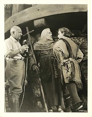
The Crusades (Two original photographs of Cecil B. DeMille from the set of the 1935 film)
Verlag: N.p., N.p., 1935
Anbieter: Royal Books, Inc., ABAA, Baltimore, MD, USA
Verkäuferbewertung 5 von 5 Sternen
Fotografie
Two vintage reference photographs of Cecil B. DeMille on the set of the 1935 film, one with Henry Wilcoxon and C. Aubrey Smith. Mimeo snipes printed on versos. DeMille's typically spectacular dramatization of the Third Crusade, launched by King Richard the Lionheart in 1187 AD. Nominated for an Academy Award for Best Cinematography. 8 x 10.25 inches. Near Fine with light edgewear and creasing in margins.
-
Map of the City of Boston and Its Environs
Verlag: New York: Baker & Tilden, 1866., 1866
Anbieter: Arader Galleries - AraderNYC, New York, NY, USA
Verkäuferbewertung 5 von 5 Sternen
Erstausgabe
"Fine folding coloured lithographed wall map (63 4/8 x 63 4/8 inches), in 36 sections laid down on cartographic linen, edges silked (browned, some folds beginning to separate, one or two section edges a bit frayed); preserved in a contemporary brown morocco backed marbled paper boards portfolio, linen ties (rebacked to style). First edition thus, showing Boston and the surrounding counties of Massachusetts at the end of the Civil War, Walling had issued a similar map in 1860. Walling was "arguably the most accomplished and interesting American mapmaker of the mid-late 19th century. His output was astonishing for its scope and quality, setting new and higher standards for others to emulate. Equally striking was the sheer volume of his output: During a 40-year career he was responsible for at least 117 largescale maps of American towns and counties, nearly 20 state maps and atlases, substantial contributions to the work of the U.S. Coast and Geodetic Survey and the U.S. Geological Survey, and important academic publications His earliest published works were maps ofProvidence, Rhode Island and Northbridge, Massachusetts, both published in Providence in 1849 with Samuel Barrett Cushing, a civil engineer and Walling's early employer. In or around 1850 he established himself on his own and moved to Boston, relocating in 1856 to New York City as his business expanded. Between 1849 and 1857 he produced at least 48 maps of towns in eastern and central Massachusetts, as well as 12 of towns in Maine, New Hampshire and Rhode Island. Interestingly none were published by Walling himself: those issued prior to 1852 bear the imprints of private publishers, or businessmen, while thereafter almost all were published "by authority of the town." "Walling's town maps are at a large scale hitherto seen only on maps of the most important American cities- generally somewhere between 1:12,000 and 1:15,000. This enables them to delineate ward or school district boundaries; topographical features such as meadows, wetlands, woodlands and elevations; the routes of roads and railroads; the locations of government buildings, schools and businesses; and the names of land owners. The Massachusetts maps typically note the town's incorporation date, population, and total acreage as well as a breakdown of the area occupied by land, roads, and water. The acreage data is an important clue to the origin of these maps: Massachusetts assessed taxes to its towns based on land valuations, so many of the maps were commissioned for administrative purposes by local governments" (Michael Buehler in "The Portolan", Sprin 2008, pages 22-33).".