Gesamtpreis (1 Artikel Artikel):
Versandziel:

h s tanner (47 Ergebnisse)
Direkt zu den wichtigsten Suchergebnissen
Suchfilter
Produktart
- Alle Product Types
- Bücher (38)
- Magazine & Zeitschriften (Keine weiteren Ergebnisse entsprechen dieser Verfeinerung)
- Comics (Keine weiteren Ergebnisse entsprechen dieser Verfeinerung)
- Noten (Keine weiteren Ergebnisse entsprechen dieser Verfeinerung)
- Kunst, Grafik & Poster (Keine weiteren Ergebnisse entsprechen dieser Verfeinerung)
- Fotografien (Keine weiteren Ergebnisse entsprechen dieser Verfeinerung)
- Karten (8)
- Manuskripte & Papierantiquitäten (1)
Zustand Mehr dazu
- Neu (8)
- Wie Neu, Sehr Gut oder Gut Bis Sehr Gut (Keine weiteren Ergebnisse entsprechen dieser Verfeinerung)
- Gut oder Befriedigend (15)
- Ausreichend oder Schlecht (1)
- Wie beschrieben (23)
Einband
Weitere Eigenschaften
- Erstausgabe (6)
- Signiert (1)
- Schutzumschlag (Keine weiteren Ergebnisse entsprechen dieser Verfeinerung)
- Angebotsfoto (30)
Sprache (2)
Gratisversand
Land des Verkäufers
Verkäuferbewertung
-

Assessing the Record and Causes of Late Triassic Extinctions (FROM: Earth-Science Reviews, Vol. 65, pp. 103-139).
Verlag: Elsevier, 2004
Anbieter: Eryops Books, Stephenville, TX, USA
Verkäuferbewertung 5 von 5 Sternen

No Binding. Zustand: Very Good. ORIGINAL2004 Reprint/Offprint of journal article; no covers issued; in very good condition. Journal.
-
BYU Studies. Vol. 40 No.2. 2001. Brigham an Abrahamic Figure, Father Brigham at Home, The Lion and the Lioness, Novels and the Kingdom, Mormon Environmental Ethics
Verlag: BYU Studies January 2001, 2001
Anbieter: The Book Garden, Bountiful, UT, USA
Verkäuferbewertung 5 von 5 Sternen
Paperback. Zustand: Very Good - Cash. Book has light rubbing and edge wear to the cover with minor reader wear to pages. Still great condition. Light creasing from opening front cover. Stock photos may not look exactly like the book.
-
BYU Studies. Vol. 40 No.2. 2001. Brigham an Abrahamic Figure, Father Brigham at Home, The Lion and the Lioness, Novels and the Kingdom, Mormon Environmental Ethics
Verlag: BYU Studies January 2001, 2001
Anbieter: The Book Garden, Bountiful, UT, USA
Verkäuferbewertung 5 von 5 Sternen
Paperback. Zustand: Very Good - Cash. Light reader wear and rubbing to the edges, corners, covers, and pages. The book is in great condition! Stock photos may not look exactly like the book.
-
Proceedings of the Aristotelian Society, New Series, vol. LXV. Containing Papers Read before the Society during the Eighty-sixth Session, 1964-1965
Verlag: Harrison & Sons, 1965
Anbieter: Windows Booksellers, Eugene, OR, USA
Verkäuferbewertung 5 von 5 Sternen
Hardcover, no dust jacket. Ex-library, otherwise very good. 282 pp.
-

A Description of the Canals and Rail Roads of the United States Comprehending Notices of All the Works of Internal Improvement Throughout the Several States Classic Reprint
Anbieter: PBShop.store US, Wood Dale, IL, USA
Verkäuferbewertung 5 von 5 Sternen
PAP. Zustand: New. New Book. Shipped from UK. Established seller since 2000.
-
A Description of the Canals and Rail Roads of the United States Comprehending Notices of All the Works of Internal Improvement Throughout the Several States Classic Reprint
Anbieter: PBShop.store UK, Fairford, GLOS, Vereinigtes Königreich
Verkäuferbewertung 4 von 5 Sternen

EUR 25,11
EUR 4,80 Versand
Versand von Vereinigtes Königreich nach USAAnzahl: 15 verfügbar
In den WarenkorbPAP. Zustand: New. New Book. Shipped from UK. Established seller since 2000.
-

A Description of the Canals and Rail Roads of the United States Comprehending Notices of All the Works of Internal Improvement Throughout the Several States Classic Reprint
Anbieter: PBShop.store US, Wood Dale, IL, USA
Verkäuferbewertung 5 von 5 Sternen
HRD. Zustand: New. New Book. Shipped from UK. Established seller since 2000.
-

The American TRavellerof Guide
Anbieter: Ria Christie Collections, Uxbridge, Vereinigtes Königreich
Verkäuferbewertung 5 von 5 Sternen
EUR 20,49
EUR 13,82 Versand
Versand von Vereinigtes Königreich nach USAAnzahl: Mehr als 20 verfügbar
In den WarenkorbZustand: New. In.
-
A Description of the Canals and Rail Roads of the United States Comprehending Notices of All the Works of Internal Improvement Throughout the Several States Classic Reprint
Anbieter: PBShop.store UK, Fairford, GLOS, Vereinigtes Königreich
Verkäuferbewertung 4 von 5 Sternen
EUR 30,95
EUR 5,79 Versand
Versand von Vereinigtes Königreich nach USAAnzahl: 15 verfügbar
In den WarenkorbHRD. Zustand: New. New Book. Shipped from UK. Established seller since 2000.
-

The American TRavellerof Guide
Anbieter: Ria Christie Collections, Uxbridge, Vereinigtes Königreich
Verkäuferbewertung 5 von 5 Sternen
EUR 32,19
EUR 13,82 Versand
Versand von Vereinigtes Königreich nach USAAnzahl: Mehr als 20 verfügbar
In den WarenkorbZustand: New. In.
-

The American TRavellerof Guide
Sprache: Englisch
Verlag: Creative Media Partners, LLC Jul 2023, 2023
ISBN 10: 1022154176 ISBN 13: 9781022154179
Anbieter: AHA-BUCH GmbH, Einbeck, Deutschland
Verkäuferbewertung 5 von 5 Sternen
Taschenbuch. Zustand: Neu. Neuware.
-

The American TRavellerof Guide
Sprache: Englisch
Verlag: Creative Media Partners, LLC Jul 2023, 2023
ISBN 10: 1020911107 ISBN 13: 9781020911101
Anbieter: AHA-BUCH GmbH, Einbeck, Deutschland
Verkäuferbewertung 5 von 5 Sternen
Buch. Zustand: Neu. Neuware - This guidebook is designed to help American travelers navigate their way through Europe.
-
Memoir on the Recent Surveys, Observations, and Internal Improvements in the United States
Verlag: H. S. Tanner, 1829
Anbieter: A Squared Books (Don Dewhirst), South Lyon, MI, USA
Verkäuferbewertung 5 von 5 Sternen
Hardcover. Zustand: Fair. 1829; *Intended to accompany Tanner's "New Map of The United States" which was sold separately and is not included* marbled paper covered boards with red leather spine and corners and gold titles; wear and discoloration around edges; corners are rounded and scuffed; 8vo, 7 3/4" to 9 3/4" tall; musty smell present; pages are toned with foxing present; page 3&4 torn at the top; 108 pages.
-
MEMOIR ON THE RECENT SURVEYS, OBSERVATIONS, AND INTERNAL IMPROVEMENTS, IN THE UNITED STATES, WITH BRIEF NOTICES OF THE NEW COUNTIES, TOWNS, VILLAGES, CANALS, AND RAIL-ROADS, NEVER BEFORE DELINEATED. INTENDED TO ACCOMPANY HIS NEW MAP OF THE UNITED STATES [ONE VOLUME ONLY]
Verlag: The Author, Philadelphia, 1830
Anbieter: Second Story Books, ABAA, Rockville, MD, USA
Verkäuferbewertung 4 von 5 Sternen
Hardcover. Second Edition. Octavo, 108, 2-8 (catalogue). Good; bound in marbled paper with quarter leather, gilt decorations but no title to spine, wear and rubbing to boards and some discoloration and fading of marbled paper, front hinge compromised but attached, wear to spine edges and corners; binding tight; text block age toned; foxing and age toning to pages; previous owner names on ffeps, stamp reading "Henry Leuba" and handwritten in ink "Hon. J. Brent" (?); RWO consignment. 1362734. Special Collections.
-
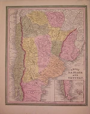
Chili La Plata and Uruguay
Verlag: Tanner, H.S., Philadelphia, 1840
Anbieter: Argosy Book Store, ABAA, ILAB, New York, NY, USA
Verkäuferbewertung 5 von 5 Sternen
unbound. Zustand: very good. Map. Engraving with original hand coloring. Image measures 15" x 12". Circa 1840, includes inset of the "South Part of Patagonia". Henry Schenck Tanner (1786-2858) was an American cartographer and statistical geographer. Born in New York, he moved to Philadelphia where he established his well-known publishing company with his brother. Tanner was the first American to publish a map of Texas, which subsequently went through eight editions. However, he is best known and most renowned for his New American Atlas.
-
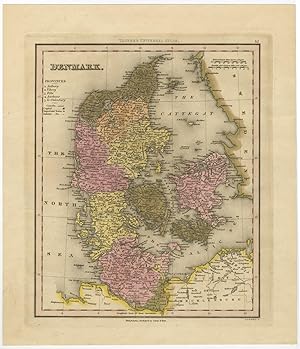
Antique Map of Denmark by Tanner (c.1846)
Verlag: Carey & Hart, 1846
Anbieter: Bartele Gallery - The Netherlands, Langweer, FRL, Niederlande
Verkäuferbewertung 5 von 5 Sternen
Karte
No Binding. Zustand: Very Good. Antique map titled 'Denmark'. This map originates from Tanner's Universal Atlas, Good condition, contemporary hand coloring. Please study image carefully. Overall size: 29.5 x 34.5 cm. Image size: 25 x 28.5 cm. The collection of Bartele Gallery includes over 50,000 authentic antique maps, sea charts, prints and books. Our Abebooks store includes a selection of maps, prints and books for SALE prices. Please visit our other online sales channels to explore our complete collection of original antique maps and prints!
-
VIEW OF THE VALLEY OF THE MISSISSIPPI OF THE EMIGRANT'S AND TRAVELLER'S GUIDE TO THE WEST. CONTAINING A GENERAL DESCRIPTION OF THAT ENTIRE COUNTRY; AND ALSO NOTICES OF THE SOIL, PRODUCTIONS, RIVERS, AND OTHER CHANNELS OF INTERCOURSE AND TRADE : AND LIKEWISE OF THE CITIES AND TOWNS, PROGRESS OF EDUCATION, &c. OF EACH STATE AND TERRITORY
Verlag: Published by the Author, Philadelphia, PA, 1834
Anbieter: Aardvark Rare Books, EUGENE, OR, USA
Verkäuferbewertung 5 von 5 Sternen
Hardcover. Zustand: Good. Second edition. 12mo, 7.4 in. x 4.5 in., pp. 372. Illustrated with colored frontis fold-out map of the United States and fourteen additional maps, twelve of which fold-out. Contemporary green cloth boardswith black title on tan panel to spine. Soiling and touch of moisture damage to front board. Sunning to spine with a couple small chips to spine panel. Light foxing throughout. Spine and hinges tight. (Sabin 2594). Includes the chapter: "Hints for Emigrants." The first edition was published in 1832. This second edition, according to the introduction, "will be found to be every way improved, especially in those portions of it which concern emigrants and travelers." It includes chapters chapters on Ohio, Indiana, Michigan, Kentucky, Tennessee, Illinois, Missouri, Mississippi, Louisiana, Alabama, and Florida, and also the history of steam-boating in the West.
-
Tanner's Map of Ohio and Indiana
Verlag: H.S. Tanner, 1836
Anbieter: Visible Voice Books, Cleveland, OH, USA
Verkäuferbewertung 5 von 5 Sternen
Karte
Zustand: Good. H.S. Tanner 1836 1836 print in hardcover boards. boards moderately rubbed and soiled. crease lines of map torn at certain folds. $NRP.
-
[Samuel Pepys, Secretary of the Admiralty and diarist.] 31 items of Pepysiana from the papers of Edwin Chappell, comprising rare printed pamphlets, booklets and offprints by him and other Pepys scholars including Sir Arthur Bryant and J. R. Tanner.
Verlag: 31 items dating from between and 1941. Most of Chappell's publications from his address 41 Westcombe Park Road Blackheath London. Several papers delivered at St Olave's Church Hart Street London. Also items from Cambridge and Greenwich, 1921
Anbieter: Richard M. Ford Ltd, London, Vereinigtes Königreich
Verkäuferbewertung 5 von 5 Sternen
Manuskript / Papierantiquität Signiert
EUR 475,39
EUR 5,19 Versand
Versand von Vereinigtes Königreich nach USAAnzahl: 1 verfügbar
In den Warenkorb31 items from the papers of leading Pepys scholar and maritime historian Edwin Chappell (1883-1938). The collection in good general condition, with light signs of age and wear. Around half the items are by Chappell himself, including offprints (many of them bearing his Blackheath address, 41 Westcombe Park Road), pamphlets, articles, proofs, and a bibliography. Other items are papers and pamphlets by: Sir Arthur Bryant; J. R. Tanner; Sir Stephen Gaselee (bearing an autograph inscription by him); T. Wellard; Arthur Ponsonby; Allen Beville Ramsay; Edward B. Powley; H. L. O. Flecker. Also a Christmas card produced by the Admiralty (containing a printed disclaimer by Chappell) and an auction catalogue (no other copy of either item traced. There are a handful of loose enclosures, and a few autograph notes by Chappell. Ten of the items (one by Chappell) are addresses delivered at the Annual Pepys Commemoration Service at St Olave's Church. The majority of items in the collection are scarce, with few if any copies traced on COPAC. The last three items, dating from after Chappell's death, were presumably added to the collection by his executor. The following list is in rough chronological order. ONE: The Spanish Books in the Library of Samuel Pepys by Stephen Gaselee, M.A., F.S.A., C.B.E. Printed at the Oxford University Press For the Bibliographical Society, 1921. 49pp. TWO: Samuel Pepys: An Address delivered at S. Olave's, Hart Street, at the Annual Pepys Commemoration Service, on May 23rd, 1928, By The Rev. T. Wellard, B.A., B.D., Rector of the Parish and Chaplain to the Pepys Club. No copy on COPAC. THREE: Samuel Pepys: An Address delivered at S. Olave's, Hart Street at the Annual Pepys Commemoration Service on June 4th, 1929 by Mr. Arthur Ponsonby, M.P. No copy on COPAC. FOUR: Samuel Pepys as a Friend: An Address delivered at S. Olave's, Hart Street, at the Annual Pepys Commemoration Service on May 20th, 1930 By J. R. Tanner, Litt.D. (Fellow of St. John's College, Cambridge). No copy on COPAC. FIVE: [auction catalogue] Catalogue of Oil Paintings, Drawings, Engravings, etc. To be sold by Auction On Monday, 4th May, 1931, at 12 noon. Hurcombs Grafton Galleries, W.1. [London] Some lots priced in pencil. Lot 55 (£24) is a portrait of Pepys by Sir Godfrey Kneller, and 56 (£12) is one of Mrs Pepys by Sir Peter Lely. No copy on OCLC WorldCat or on COPAC, and no other copy traced. Loosely inserted is a cutting of an advertisement by Hurcombs, from the Connoisseur, announcing the sale 'early in May' of the two portraits, both 'unimpeachable, coming from Samuel's descendants', and giving photographic reproductions of both portraits. SIX: Catalogue of Pepysiana belonging to Mr. Edwin Chappell exhibited at the Annual General Meeting of the Society for Nautical Research held at the Royal Naval College Greenwich 8th. July 1931. Accompanying text signed in type by Chappell, from his Blackheath address. Three copies only on COPAC. SEVEN: Samuel Pepys, The Childlike Diarist: An Address delivered at S. Olave's, Hart Street, at the Annual Pepys Commemoration Service on June 2nd, 1932. By the Master of Magdalene College, Cambridge. [i.e. Allen Beville Ramsay] EIGHT: Elizabeth Pepys by Edwin Chappell. Offprint. Reprinted from the Somerset Year Book, 1933. 'With the compliments of Mr. E. Chappell'. A date is corrected in autograph. One copy on COPAC. NINE: Samuel Pepys: An Address delivered at S. Olave's Hart Street at the Tercentenary Celebration of the Birth of Samuel Pepys (February 23rd, 1633) Held at the Church on February 23rd, 1933 By the Rev. Prebendary Wellard, B.A., B.D. Rector of the Church and Chaplain to the Pepys Club. With handbill advertisement for the service loosely inserted. No copy of either item on COPAC. TEN: Samuel Pepys by Edwin Chappell. Offprint. Reprinted from The Mariner's Mirror, April 1933. 'With the Compliments of Mr. Edwin Chappell'. Loosely inserted leaf carrying family tree of 'WILLIAM PEPIS | Will proved 1519'. ELEVE.
-
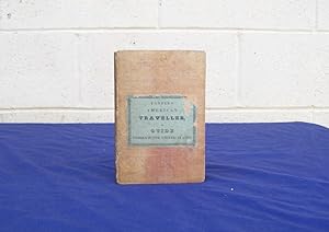
The American Traveller or Guide Through the United States.
Verlag: Philadelphia: H.S. Tanner., 1834
Anbieter: Centerbridge Books, Old Saybrook, CT, USA
Verkäuferbewertung 5 von 5 Sternen
Erstausgabe
Hardcover. Zustand: Good. 1st Edition. Brown cloth with cover label. 16mo. 144pp. Large folding hand-colored map at front plus four smaller doublepage maps in text. Scarce first edition of this work by the American cartographer and statistical geographer Henry Schenck Tanner. Tanner was a Philadelphia publisher best known for his New American Atlas published in five parts from 1819 to 1823. The folding map extends from the states of Missouri, Arkansas and Louisiana to the Eastern states and shows the roads, canals and railroad routes. The four smaller maps show the cities of Philadelphia, Boston, New York and Baltimore. This 1834 edition does not appear to have the smaller scenic plates included in later printings. The binding is in good condition with some spotting to the covers and some wear to the front hinge near the bottom. The cover label has some chipping at the edges. The text is in good condition with some scattered foxing and light corner wear. The large map, which has come loose from the binding, is in very nice condition with some light browning and several small closed tears at the inside folds. The text maps are all very good with some light browning. HOWES T24. SABIN 94311.
-
An Atlas of Ancient Geography: comprehended in Sixteen Maps, Selected from the Most Approved Works, to Elucidate the Writings of the Ancient Authors, Both Sacred and Profane
Verlag: Philadelphia, H.S. Tanner,, 1826, 1826
Anbieter: Jackson Street Booksellers, Omaha, NE, USA
Verkäuferbewertung 5 von 5 Sternen
Erstausgabe
Hardcover. Zustand: Very Good. No Jacket. 1st Edition. A Very Good copy of this First edition that has been rebound in quarter red leather with marbled boards and endpapers. All 16 hand colored maps present and in Very Good condition.
-
The American Traveler; Or Guide Through the United States
Verlag: Published by the author, Philadelphia, 1836
Anbieter: The Kelmscott Bookshop, ABAA, Savage, MD, USA
Verbandsmitglied: ABAA ESA ILAB IOBA MBS
Verkäuferbewertung 5 von 5 Sternen
Hardcover. Zustand: Very Good. Hardcover. Scarce second edition of this important compilation of facts and figures "useful to the American traveler", e.g. population figures, distances between major cities via stagecoach, canal or steamboat, and principal objects of curiosity in or around larger towns, and much more. With brief notices of the several states, cities, principal towns, canals and railroads. Henry Schenck Tanner ( 1786-1858 ), cartographer and statistical geographer, was born in New York City, the son of John Tanner, a ship master, and Ann Schenck. His father died when he was six, and the family was then headed by his older brother Benjamin Tanner , who had been trained and had begun a career as an engraver. In 1800 Benjamin moved to Philadelphia, Pennsylvania, then the preeminent center of publishing and graphic arts, where Henry later apprenticed with him. Benjamin built up an active and varied engraving business. Bound in original brown cloth covers with paper title label to front. Covers are soiled, rubbed, and bumped. Title label is chipped and stained. Spine is rebacked with later brown cloth. There is a large hand colored folding map of the eastern United States in the rear of the book, stretching west of the Mississippi to include parts of Arkansas and Missouri. The map identifies capitals, important towns, villages, public houses, turnpike and common roads, and railroads. There are 18 insets surrounding the map, showing city plans, the surroundings of various cities, and a map of the Hudson River. The map has scattered stains and closed tears along some of the folds. The small traveler's guide features four double-page plans of the major American cities: Baltimore, Boston, New York, and Philadelphia. There are also seven small plates, including two of Niagara Falls and one of West Point. Two ownership signatures in ink on front free endpaper. The pages are generally clean with some spotting, primarily in the margins. Very good condition. Measures 3 x 6 inches. 144 pages. Howes T-24. AMERH/012224.
-
A Description of the Canals and Rail Roads of the United States, Comprehending Notices of All the Works of Internal Improvement Throughout the Several States
Verlag: T R Tanner & J Disturnell, New York, 1840
Anbieter: Old New York Book Shop, ABAA, Atlanta, GA, USA
Verkäuferbewertung 5 von 5 Sternen
Erstausgabe
Hardcover. Zustand: Good. First Edition. 272p + 4 page catalogue, octavo illustrated with 3 foldout maps and 2 foldout charts. Large foldout map laid in in the rear, taped on the back at folds, chipped along the edges. 1 inch chip to the corner of the half title, chipped at the spine heads. Engraved bookplate of George B Leighton Monadnock Farms, name on front fly leaf.
-
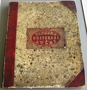
NEW UNIVERSAL ATLAS Containing Maps of the various Empires, Kingdoms, States and Republics of the World with a Special Map of Each of the United States, Plans of Cities etc. Comprehended in seventy sheets and forming a series of 117 Maps, Plans and Sections.
Verlag: S. Augustus Mitchell, Philadelphia, 1846
Anbieter: JBK Books, North Manchester, IN, USA
Verkäuferbewertung 5 von 5 Sternen
Erstausgabe
Hardcover. Zustand: Good. 1st Edition. 18" x 14". Marbled boards; leather spine and corners; with gilt-stamped label. Awesome colored and historic maps; all maps intact and in VERY GOOD condition. Atlas with broken inner front hinge and split at spine edge. Included are 71 numbered sheets (while Title indicates 70). This rare atlas is unmarked and has no ownership or library markings.
-

Peru and Bolivia
Verlag: Tanner, H.S., Philadelphia, 1836
Anbieter: Argosy Book Store, ABAA, ILAB, New York, NY, USA
Verkäuferbewertung 5 von 5 Sternen
unbound. Map. Engraving with original hand coloring. Image measures 12" x 14 1/4" This 1836 map of Peru and Bolivia provides geographical, topographical, and political information. Hand-colored to show provinces, with topography rendered by hachure. Rivers, cities, towns, coastal and topographical features are labeled. In very good condition, with minor chips to lower margin, and archival linen residue to upper edge - not affecting the image. Henry Schenck Tanner (1786-2858) was an American cartographer and statistical geographer. Born in New York, he moved to Philadelphia where he established his well-known publishing company with his brother. Tanner was the first American to publish a map of Texas, which subsequently went through eight editions. However, he is best known and most renowned for his New American Atlas. This fine map of Brazil is a wonderful example of his work.
-
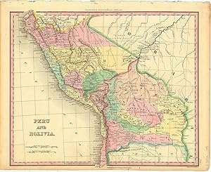
Peru and Bolivia.
Verlag: PhiladelphiaTanner. -46, 1836
Anbieter: Robert Frew Ltd. ABA ILAB, London, Vereinigtes Königreich
Verbandsmitglied: ABA ILAB PBFA
Verkäuferbewertung 5 von 5 Sternen
Karte
EUR 89,14
EUR 11,54 Versand
Versand von Vereinigtes Königreich nach USAAnzahl: 1 verfügbar
In den Warenkorb29 x 35 cm. Original colour. Single page map of Peru and Bolivia. Very good condition.
-
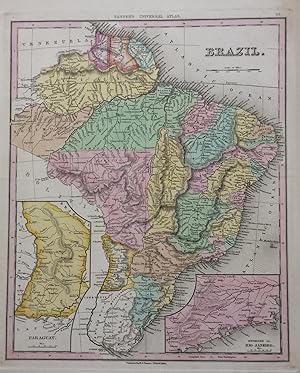
Brazil
Verlag: Tanner, H.S., Philadelphia
Anbieter: Argosy Book Store, ABAA, ILAB, New York, NY, USA
Verkäuferbewertung 5 von 5 Sternen
unbound. Map. Engraving with original hand coloring. Image measures 14.25 x 11.5 inches. Page measures 17.25 x 13.25 inches. This 1839 map provides geographical, topographical, and political information about the Empire of Brazil. Large but sparsely populated, the country at this time enjoyed a general stability that manifests here in Tanner's dignified rendering. Hand coloring distinguishes provinces, while hachures show relief. In addition to capitancies and major cities, ports, islands, and other coastal features are also labeled. An inset of the Environs of Rio and an inset of Paraguay are included. Henry Schenck Tanner (1786-2858) was an American cartographer and statistical geographer. Born in New York, he moved to Philadelphia where he established his well-known publishing company with his brother. Tanner was the first American to publish a map of Texas, which subsequently went through eight editions. However, he is best known and most renowned for his New American Atlas. This fine map of Brazil is a wonderful example of his work.
-
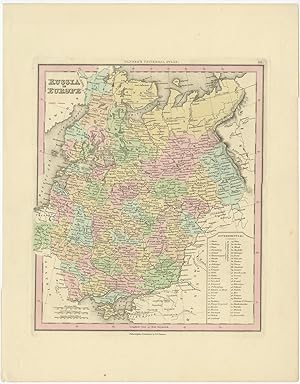
Antique Map of Russia in Europe by Tanner (1836)
Erscheinungsdatum: 1836
Anbieter: Bartele Gallery - The Netherlands, Langweer, FRL, Niederlande
Verkäuferbewertung 5 von 5 Sternen
Karte
No Binding. Zustand: Good. Antique map titled 'Russia in Europe'. This map originates from Tanner's Universal Atlas. Published in Philadelphia. Very good condition apart from some staining, please study image carefully. Overall size: 31.5 x 40 cm. Image size: 24.5 x 29 cm. BG-00499. The collection of Bartele Gallery includes over 50,000 authentic antique maps, sea charts, prints and books. Our Abebooks store includes a selection of maps, prints and books for SALE prices. Please visit our other online sales channels to explore our complete collection of original antique maps and prints!
-
Memoir on the recent surveys, observations, and internal improvements in the United States, with brief notices of the new counties, towns, villages, canals, and rail roads, never before deliniated
Verlag: published by the author, Philadelphia, 1829
Anbieter: Rulon-Miller Books (ABAA / ILAB), St. Paul, MN, USA
Verbandsmitglied: ABAA ILAB RMABA
Verkäuferbewertung 5 von 5 Sternen
Erstausgabe
First Edition. First edition, 16mo, pp. [2], 108, 8; half calf over marbled boards; upper board nearly loose, lower half of spine perished, pages foxed, fair only. "Intended to accompany [Tanner's] new map of the United States," which was sold separately and is not included. Final 8 pages listing 80 published maps. Streeter VI, 3834; Sabin 94318.
-
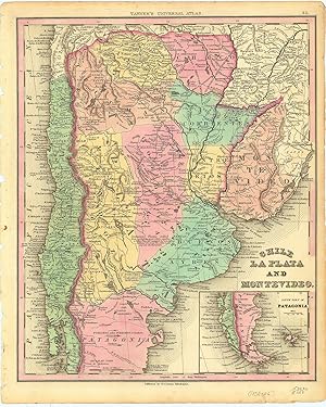
Chile La Plata And Montevideo.
Verlag: PhiladelphiaTanner. -46, 1836
Anbieter: Robert Frew Ltd. ABA ILAB, London, Vereinigtes Königreich
Verbandsmitglied: ABA ILAB PBFA
Verkäuferbewertung 5 von 5 Sternen
Karte
EUR 148,56
EUR 11,54 Versand
Versand von Vereinigtes Königreich nach USAAnzahl: 1 verfügbar
In den Warenkorb35.9 x 29.5 cm. Original colour. Single page map of the southern half of South America, encompassing Argentina, Chile, Paraguay and Uruguay. Inset map showing the soutjern extension of the continent into Patagonia and Tierra del Fuego. Very good condition.


![Bild des Verkäufers für MEMOIR ON THE RECENT SURVEYS, OBSERVATIONS, AND INTERNAL IMPROVEMENTS, IN THE UNITED STATES, WITH BRIEF NOTICES OF THE NEW COUNTIES, TOWNS, VILLAGES, CANALS, AND RAIL-ROADS, NEVER BEFORE DELINEATED. INTENDED TO ACCOMPANY HIS NEW MAP OF THE UNITED STATES [ONE VOLUME ONLY] zum Verkauf von Second Story Books, ABAA](https://pictures.abebooks.com/inventory/md/md31384088197.jpg)