Greenleaf jeremiah (17 Ergebnisse)

- Softcover
Anbieter: PBShop.store US, Wood Dale, IL, USAPBShop.store US
Verkäufer/-in kontaktierenVerkäufer/-in mit 5 SternenZustand: Neu
EUR 24,28
Versand nach gratisVersand innerhalb von USAAnzahl: 15 verfügbar
PAP. Zustand: New. New Book. Shipped from UK. Established seller since 2000.

- Softcover
Anbieter: PBShop.store US, Wood Dale, IL, USAPBShop.store US
Verkäufer/-in kontaktierenVerkäufer/-in mit 5 SternenZustand: Neu
EUR 24,70
Versand nach gratisVersand innerhalb von USAAnzahl: 15 verfügbar
PAP. Zustand: New. New Book. Shipped from UK. Established seller since 2000.
- Softcover
Anbieter: PBShop.store UK, Fairford, GLOS, Vereinigtes KönigreichPBShop.store UK
Verkäufer/-in kontaktierenVerkäufer/-in mit 5 SternenZustand: Neu
EUR 24,07
EUR 3,82 VersandVersand von Vereinigtes Königreich nach USAAnzahl: 15 verfügbar
PAP. Zustand: New. New Book. Shipped from UK. Established seller since 2000.
- Softcover
Anbieter: PBShop.store UK, Fairford, GLOS, Vereinigtes KönigreichPBShop.store UK
Verkäufer/-in kontaktierenVerkäufer/-in mit 5 SternenZustand: Neu
EUR 24,37
EUR 3,82 VersandVersand von Vereinigtes Königreich nach USAAnzahl: 15 verfügbar
PAP. Zustand: New. New Book. Shipped from UK. Established seller since 2000.

- Hardcover
Anbieter: PBShop.store US, Wood Dale, IL, USAPBShop.store US
Verkäufer/-in kontaktierenVerkäufer/-in mit 5 SternenZustand: Neu
EUR 34,55
Versand nach gratisVersand innerhalb von USAAnzahl: 15 verfügbar
HRD. Zustand: New. New Book. Shipped from UK. Established seller since 2000.
- Hardcover
Anbieter: PBShop.store UK, Fairford, GLOS, Vereinigtes KönigreichPBShop.store UK
Verkäufer/-in kontaktierenVerkäufer/-in mit 5 SternenZustand: Neu
EUR 32,76
EUR 4,83 VersandVersand von Vereinigtes Königreich nach USAAnzahl: 15 verfügbar
HRD. Zustand: New. New Book. Shipped from UK. Established seller since 2000.

- Softcover
Anbieter: AHA-BUCH GmbH, Einbeck, DeutschlandAHA-BUCH GmbH
Verkäufer/-in kontaktierenVerkäufer/-in mit 5 SternenZustand: Neu
EUR 20,30
EUR 60,39 VersandVersand von Deutschland nach USAAnzahl: 2 verfügbar
Taschenbuch. Zustand: Neu. Neuware - 'Grammar Simplified, Or, An Ocular Analysis Of The English Language' offers a systematic and accessible approach to understanding English grammar. Designed for students and educators alike, this book presents a clear breakdown of grammatical concepts, making it an invaluable resource for anyo…ne seeking to improve their language skills. Jeremiah Greenleaf's work provides a comprehensive overview of English grammar, focusing on clarity and ease of understanding. This edition preserves the original structure and content, ensuring that readers can benefit from Greenleafâ?(TM)s insightful approach to language education. A valuable addition to any personal library, offering timeless guidance on the fundamentals of English grammar.This work has been selected by scholars as being culturally important, and is part of the knowledge base of civilization as we know it. This work was reproduced from the original artifact, and remains as true to the original work as possible. Therefore, you will see the original copyright references, library stamps (as most of these works have been housed in our most important libraries around the world), and other notations in the work.This work is in the public domain in the United States of America, and possibly other nations. Within the United States, you may freely copy and distribute this work, as no entity (individual or corporate) has a copyright on the body of the work.As a reproduction of a historical artifact, this work may contain missing or blurred pages, poor pictures, errant marks, etc. Scholars believe, and we concur, that this work is important enough to be preserved, reproduced, and made generally available to the public. We appreciate your support of the preservation process, and thank you for being an important part of keeping this knowledge alive and relevant.

- Softcover
Anbieter: preigu, Osnabrück, Deutschlandpreigu
Verkäufer/-in kontaktierenVerkäufer/-in mit 5 SternenZustand: Neu
EUR 11,90
EUR 70,00 VersandVersand von Deutschland nach USAAnzahl: 5 verfügbar
Taschenbuch. Zustand: Neu. Lives of All the Presidents of the United States, to Which Is Added the Declaration of Independence, and the Constitution of the United States | Jeremiah Greenleaf | Taschenbuch | Englisch | 2025 | Antigonos Verlag | EAN 9783563801710 | Verantwortliche Person für die EU: preigu GmbH & Co. KG, Lengerich…er Landstr. 19, 49078 Osnabrück, mail[at]preigu[dot]de | Anbieter: preigu.

- Hardcover
Anbieter: AHA-BUCH GmbH, Einbeck, DeutschlandAHA-BUCH GmbH
Verkäufer/-in kontaktierenVerkäufer/-in mit 5 SternenZustand: Neu
EUR 37,44
EUR 61,23 VersandVersand von Deutschland nach USAAnzahl: 2 verfügbar
Buch. Zustand: Neu. Neuware - 'Grammar Simplified, Or, An Ocular Analysis Of The English Language' offers a systematic and accessible approach to understanding English grammar. Designed for students and educators alike, this book presents a clear breakdown of grammatical concepts, making it an invaluable resource for anyone seek…ing to improve their language skills.

Verlag: Brattleboro: G.R. French, 1842., 1842
- Hardcover
Anbieter: Arader Galleries - AraderNYC, New York, NY, USAArader Galleries - AraderNYC
Verkäufer/-in kontaktierenVerkäufer/-in mit 5 SternenZustand: Gebraucht
EUR 8.122,19
Versand nach gratisVersand innerhalb von USAAnzahl: 1 verfügbar
Hardcover. Folio (14 4/8 x 12 inches). Engraved title-page, Contents leaf, and 65 engraved maps, all with original hand-colour in full (some spotting to text leaves, one or two pale stains). Original half calf, brown cloth, red morocco lettering-piece on the front cover (worn and stained). First published in 1840, based on David… H. Burr's "Universal Atlas" of 1836. This atlas contains the rare fine large-scale map of Texas "Texas Compiled from the Latest and Best Authorities". Greenleaf's map is an early map to show the individual counties, each colored. Two other maps in the atlas are of Texas interest: "North America", shows Texas as an independent republic; as does "The United States of Mexico". Streeter very famously did not include this atlas in his collection because: "Examples of atlas maps not separately published, and so not included, are Texas from the Latest Authorities, scale about seventy miles to the inch, found in the 1842 Greenleaf Atlas" (Streeter, Texas, volume III, page 330). Other maps of interest include the four hemispheres of the world, a "Map of the Country Twenty-Five Miles Round the City of New York", which is also circular; and "New Holland and New Zealand".Day, Maps of Texas, p. 22. Phillips, America, p. 843; Atlases 784.

Verlag: Jeremiah Greenleaf, Boston, 1844
Anbieter: Argosy Book Store, ABAA, ILAB, New York, NY, USAArgosy Book Store, ABAA, ILAB
Verkäufer/-in kontaktierenVerkäufer/-in mit 5 SternenZustand: Gebraucht
EUR 135,37
EUR 5,26 VersandVersand innerhalb von USAAnzahl: 1 verfügbar
unbound. Map. Engraving with original hand coloring. Sheet measures 14 3/8" x 11 7/8". Beautiful map of the Northern hemispheres centered on the North pole. Includes extents of major explorers. In very good condition. Two minor spots over Russia and near the equator in the Atlantic Ocean. Jeremiah Greenleaf (1791-1864) was an Am…erican cartographer and publisher based in Brattleboro, Vermont. He is best remembered for his publication "A New Universal Atlas", a reissue of David Burr's 1835/1836 atlas. Greenleaf's first edition was published in 1840, with updated editions issued through 1849.
Verlag: G. R. French, Brattleboro, 1840
Anbieter: Argosy Book Store, ABAA, ILAB, New York, NY, USAArgosy Book Store, ABAA, ILAB
Verkäufer/-in kontaktierenVerkäufer/-in mit 5 SternenZustand: Gebraucht
EUR 135,37
EUR 5,26 VersandVersand innerhalb von USAAnzahl: 1 verfügbar
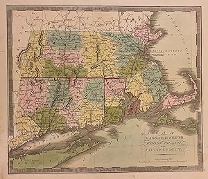
unbound. Map. Engraving with original hand coloring. Image measures 10 3/4" x 12 1/2" Classic first edition Greenleaf map of Massachusetts, Connecticut, and Rhode Island divided into counties. Shows many place names, major routes, railroads, waterways and topographical details. Includes the Long Island Sound and part of Long Isl…and. In very good condition with one faint stain below Sakonnet Point, and some wear to lower left margin not affecting the image. Jeremiah Greenleaf (1791-1864) was an American cartographer and publisher based in Brattleboro, Vermont. He is best remembered for his publication "A New Universal Atlas", a reissue of David Burr's 1835/1836 atlas. Greenleaf's first edition was published in 1840, with updated editions issued through 1849.
Verlag: G. R. French, Brattleboro, VT, 1842
Anbieter: Antipodean Books, Maps & Prints, ABAA, Garrison, NY, USAAntipodean Books, Maps & Prints, ABAA
Verkäufer/-in kontaktierenVerkäufer/-in mit 4 SternenZustand: Gebraucht
EUR 273,45
EUR 8,76 VersandVersand innerhalb von USAAnzahl: 1 verfügbar
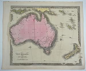
Maps. Zustand: Very good overall. In 1840, Greenleaf first reissued Burr's 1936 edition of the New Universal Atlas. This was published by G. R. French in Brattleboro, VT. The changes between 1840 and 1842 are extensive, even on this map. The 1842 updates edition include a long vertical dividing line, W. Australia in the west and… S. Australia in the lower center, Australia Felix in the lower right quadrant; Freemantle (sic), Melborne (sic), Perth, and Albany are added for the first time, and "Swan R. is altered to "Swan R. Colony". Mt. Arden at the top of Spencers Gulf is now called Mt. Brown. The Murray Darling River now outlets into Encounter Bay. Additions to New Zealand include Cascade Pt. and altered text for "Bank's Peninsula" on the South Island and the addition of C. Maria Van Diemen on the North Island. Bib ID 2905662. Scale [ca. 1:20 000 000]. Map of Australia and New Zealand with relief shown by hachures. Pl. 26 from: A new universal atlas, comprising separate maps of all the principal empires, kingdoms & states throughout the world. Brattleboro, Vt. : G.R. French, 1842. Prime meridians: Greenwich and Washington. Includes the New Hebrides and Solomon Islands, part of New Guinea and Indonesia & the Auckland Islands. 27.5x32 cm, orig. color. Not in Tooley; Phillips 784. Faint pen mark in lower ocean.

Verlag: G. R. French, Brattleboro, 1849
Anbieter: Argosy Book Store, ABAA, ILAB, New York, NY, USAArgosy Book Store, ABAA, ILAB
Verkäufer/-in kontaktierenVerkäufer/-in mit 5 SternenZustand: Gebraucht
EUR 360,99
EUR 5,26 VersandVersand innerhalb von USAAnzahl: 1 verfügbar
unbound. Map. Engraving with original hand coloring. Image measures 12 1/2" x 10 3/4" Classic map of Maine divided into counties. Shows many place names, major routes, railroads, waterways and topographical details. Greenleaf's delicate treatment of this map complements the natural beauty of Maine's geographical elements. Unlike… earlier editions of this map, the northern boundary line is colored to its present-day border as established in the Treaty of 1842, previously labeled as "Boundary as recommended by the King of the Netherlands." The disputed boundary line is also included north of the colored area, extending outside the map's border. This line is labeled as "Boundary formerly claimed by Maine." This was Greenleaf's final edition of this map, published in 1849 by Greenleaf after a map by David Burr. (Thompson 67) In very good condition with overall toning and minor discoloration at places. Scarce. Jeremiah Greenleaf (1791-1864) was an American cartographer and publisher based in Brattleboro, Vermont. He is best remembered for his publication "A New Universal Atlas", a reissue of David Burr's 1835/1836 atlas. Greenleaf's first edition was published in 1840, with updated editions issued through 1849.

Verlag: G.R. French c. 1842, Brattleboro, Vermont, 1842
Anbieter: William Chrisant & Sons, ABAA, ILAB. IOBA, ABA, Ephemera Society, Fort Lauderdale, FL, USAWilliam Chrisant & Sons, ABAA, ILAB. IOBA, ABA, Ephemera Society
Verkäufer/-in kontaktierenVerkäufer/-in mit 5 SternenZustand: Gebraucht
EUR 618,19
EUR 7,89 VersandVersand innerhalb von USAAnzahl: 1 verfügbar
Antique map of North America with original hand-coloring from Greenleaf's New Universal Atlas. Interesting portrayal of a nascent Texas & an optimistic view of America's northwest border. 12 x 14 1/4 inches.
 Weitere Bilder
- Hardcover
Anbieter: Second Story Books, ABAA, Rockville, MD, USASecond Story Books, ABAA
Verkäufer/-in kontaktierenVerkäufer/-in mit 4 SternenZustand: Gebraucht
EUR 3.158,63
EUR 6,13 VersandVersand innerhalb von USAAnzahl: 1 verfügbar
Hardcover. Revised Edition. Quarto, 11, [3] pages, 65 [plates]. In Good condition. Half-bound in brown leather with marbled paper boards and a Morocco label with gilt lettering to the front board. Boards have chipping to the extremities, rubbing wear throughout, and minor soiling. Textblock has cracking to hinges, tape to the re…ar free end page, offsetting to the verso of some plates, age toning throughout, foxing to some pages, and stains to some pages throughout. Shelved in Room A Oversized. 1404175. Special Collections.

Anbieter: Argosy Book Store, ABAA, ILAB, New York, NY, USAArgosy Book Store, ABAA, ILAB
Verkäufer/-in kontaktierenVerkäufer/-in mit 5 SternenZustand: Gebraucht
EUR 257,20
EUR 5,26 VersandVersand innerhalb von USAAnzahl: 1 verfügbar
unbound. Map. Engraving with original hand coloring. Image measures 13" x 11" Classic map of Mississippi divided into counties. Early Railroad lines noted throughout. Shows many place names, major routes, waterways and topographical details. In very good condition.> Jeremiah Greenleaf (1791-1864) was an American cartographer and… publisher based in Brattleboro, Vermont. He is best remembered for his publication "A New Universal Atlas", a reissue of David Burr's 1835/1836 atlas. Greenleaf's first edition was published in 1840, with updated editions issued through 1849.


