Gesamtpreis (1 Artikel Artikel):
Versandziel:

getmapping brown martin (3 Ergebnisse)
Direkt zu den wichtigsten Suchergebnissen
Suchfilter
Produktart
- Alle Product Types
- Bücher (3)
- Magazine & Zeitschriften (Keine weiteren Ergebnisse entsprechen dieser Verfeinerung)
- Comics (Keine weiteren Ergebnisse entsprechen dieser Verfeinerung)
- Noten (Keine weiteren Ergebnisse entsprechen dieser Verfeinerung)
- Kunst, Grafik & Poster (Keine weiteren Ergebnisse entsprechen dieser Verfeinerung)
- Fotografien (Keine weiteren Ergebnisse entsprechen dieser Verfeinerung)
- Karten (Keine weiteren Ergebnisse entsprechen dieser Verfeinerung)
- Manuskripte & Papierantiquitäten (Keine weiteren Ergebnisse entsprechen dieser Verfeinerung)
Zustand Mehr dazu
- Neu (Keine weiteren Ergebnisse entsprechen dieser Verfeinerung)
- Wie Neu, Sehr Gut oder Gut Bis Sehr Gut (Keine weiteren Ergebnisse entsprechen dieser Verfeinerung)
- Gut oder Befriedigend (2)
- Ausreichend oder Schlecht (Keine weiteren Ergebnisse entsprechen dieser Verfeinerung)
- Wie beschrieben (1)
Einband
- alle Einbände
- Hardcover (3)
- Softcover (Keine weiteren Ergebnisse entsprechen dieser Verfeinerung)
Weitere Eigenschaften
- Erstausgabe (2)
- Signiert (Keine weiteren Ergebnisse entsprechen dieser Verfeinerung)
- Schutzumschlag (1)
- Angebotsfoto (3)
Sprache (1)
Gratisversand
Land des Verkäufers
Verkäuferbewertung
-
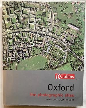
Oxford: The Photographic Atlas
Anbieter: Leabeck Books, Steventon, OXON, Vereinigtes Königreich
Verkäuferbewertung 5 von 5 Sternen

Erstausgabe
EUR 11,94
EUR 23,18 Versand
Versand von Vereinigtes Königreich nach USAAnzahl: 1 verfügbar
In den WarenkorbHardcover. Zustand: Very Good. Zustand des Schutzumschlags: Very Good. 1st Edition. London: HarperCollins, 2004. First edition. 187[5]p. Colour aerial photographs throughout. Produced by Getmapping. Prepared by Martin Brown, texts by Ian Harrison. A very good copy in a very good unclipped dust jacket. Loosely inserted are four supplements to the Oxford Times of May-June 2007 entitled 'Oxfordshire from the Air'; each 12-page issue covers a different part of the county and consists of colour aerial photographs. All are in good condition, slightly toned, with some wear to edges. Whereas the photographs in the book are all taken from directly overhead, those in the supplements are taken from lower down and at at angle, thus providing details of the buildings.
-

England The Photographic Atlas.
Sprache: Englisch
Verlag: 1st edit., Harper/Collins, Getmapping, 2001. Very good copy, 2001
ISBN 10: 0007122772 ISBN 13: 9780007122776
Anbieter: R.G. Watkins Books and Prints, Ilminster, SOMER, Vereinigtes Königreich
Verkäuferbewertung 5 von 5 Sternen
EUR 17,91
EUR 32,46 Versand
Versand von Vereinigtes Königreich nach USAAnzahl: 1 verfügbar
In den WarenkorbHardcover. Zustand: Very good. No Jacket. Colour aerial phootographs,maps, index. Large folio (18in x 12.5in) orig. cloth, slight stain on front cover,
-

England : the photographic atlas / aerial photography and processing by the team at Getmapping
Sprache: Englisch
Verlag: London: HarperCollinsPublishers, 2001
ISBN 10: 0007122772 ISBN 13: 9780007122776
Erstausgabe
First Edition. Fine cloth copy in an equally fine dust-wrapper. Inside a protective plastic case. Hinges starting. Particularly well-preserved; tight, bright, clean and especially sharp-cornered. Physical description: 1 atlas (755, [25] p.) : chiefly col. ill., col. maps ; 46 cm. Notes: Scale of maps (p. 748-775). Vertical medium-altitude (5,500 feet) aerial photographs. Geocorrected to Ordnance Survey Land-Line data. Includes index. Subjects: Aerial photography in archaeology England. Atlases. England Aerial photographs. England Remote sensing images. England Maps. England ; Maps. England ; Aerial photographs.,England ; Pictorial works. England ; Pictorial works. England. Remote sensing - ; atlases 2001. England Maps, Topographic. England ; Aerial photographs. 3 Kg.