Gesamtpreis (1 Artikel Artikel):
Versandziel:

fremont john 1813 (27 Ergebnisse)
Direkt zu den wichtigsten Suchergebnissen
Suchfilter
Produktart
- Alle Product Types
- Bücher (25)
- Magazine & Zeitschriften (Keine weiteren Ergebnisse entsprechen dieser Verfeinerung)
- Comics (Keine weiteren Ergebnisse entsprechen dieser Verfeinerung)
- Noten (Keine weiteren Ergebnisse entsprechen dieser Verfeinerung)
- Kunst, Grafik & Poster (2)
- Fotografien (Keine weiteren Ergebnisse entsprechen dieser Verfeinerung)
- Karten (Keine weiteren Ergebnisse entsprechen dieser Verfeinerung)
- Manuskripte & Papierantiquitäten (Keine weiteren Ergebnisse entsprechen dieser Verfeinerung)
Zustand Mehr dazu
- Neu (Keine weiteren Ergebnisse entsprechen dieser Verfeinerung)
- Wie Neu, Sehr Gut oder Gut Bis Sehr Gut (Keine weiteren Ergebnisse entsprechen dieser Verfeinerung)
- Gut oder Befriedigend (5)
- Ausreichend oder Schlecht (Keine weiteren Ergebnisse entsprechen dieser Verfeinerung)
- Wie beschrieben (22)
Einband
Weitere Eigenschaften
Sprache (2)
Gratisversand
Land des Verkäufers
Verkäuferbewertung
-
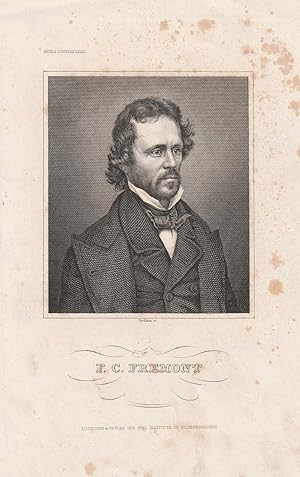
"F. C. Fremont". Stahlstich-Porträt von Nordheim.
Verlag: Hildburghausen, Bibliographisches Institut um 1850., 1850
Anbieter: Antiquariat Dennis R. Plummer, Bingen am Rhein, Deutschland
Verkäuferbewertung 5 von 5 Sternen

Kunst / Grafik / Poster
1 Blatt, verso weiß. Zustand: Akzeptabel. Bild ca. 10,5 x 9 cm, Blatt ca. 21 x 14 cm. Brustbild-Portait. John Charles Frémont (1813-1890) war US-amerikanischer Entdecker und Politiker. - Recht stockfleckig, gering gebräunt, sonst gutes Exemplar. Sprache: Deutsch Gewicht in Gramm: 150.
-

Fremont, John Charles - American Explorer - an Engraved Portrait
Sprache: Englisch
Anbieter: K Books Ltd ABA ILAB, York, YORKS, Vereinigtes Königreich
Verbandsmitglied: ABA ILAB PBFA
Verkäuferbewertung 5 von 5 Sternen
EUR 29,83
EUR 22,59 Versand
Versand von Vereinigtes Königreich nach USAAnzahl: 1 verfügbar
In den WarenkorbNo Binding. Zustand: Very Good. A splendid engraved portrait, printed in circa 1830 Mounted and ready to frame. This is an excellent opportunity to purchase an attractive and decorative engraved portrait.
-
THE EXPEDITIONS OF JOHN CHARLES FRÉMONT [Four volumes]
Sprache: Englisch
Verlag: University of Illinois Press, Urbana, 1970
ISBN 10: 0252000862 ISBN 13: 9780252000867
Anbieter: Second Story Books, ABAA, Rockville, MD, USA
Verkäuferbewertung 4 von 5 Sternen

Hardcover. Octavo, Four volumes. In Very Good condition with Very Good dust jackets. Spines are tan with black print. Price clipped in first volume; price unclipped in second volume: "$17.50". Boards in brown cloth with gold print. Illustrated: b&w frontispieces and plates, some folded, maps. CONTENTS: Vol. 1. Travels from 1838 to 1844 (1970; ISBN 0252000862) xliv, 854 pages - Vol. 2. The Bear Flag Revolt and the Court-Martial (1973; ISBN 0252002490) lii, 519 pages - Vol. 3. Travels from 1848 to 1854 (1984; ISBN 0252004167) lxxxiii, 641 pages - [Vol. 4.] Map Portfolio (1970; portfolio in slipcase; portfolio contains a 16 page commentary by D. Jackson and 5 maps of the Frémont expeditions, map 4 being in 7 sections. [Oversized book(s). Additional postage necessary for expedited/international orders. Economy International shipping unavailable due to size/weight restrictions. For international/expedited customers, please inquire for rates]. NOTE: Shelved in Locked Annex Area, Multi-Volume Area (ND-MV). 1376575. FP New Rockville Stock.
-

Porträt. Original - Stahlstich von Nordheim, 23,5 x 14,5 cm, ca. 1850.
Anbieter: Antiquariat Michael Eschmann, Groß-Gerau, Deutschland
Verkäuferbewertung 5 von 5 Sternen
Kunst / Grafik / Poster
0. Sprache: Deutschu.
-
THE EXPLORING EXPEDITION TO THE ROCKY MOUNTAINS, OREGON AND CALIFORNIA, OREGON AND CALIFORNIA? TO WHICH IS ADDED A DESCRIPTION OF THE PHYSICAL GEOGRAPHY OF CALIFORNIA WITH RECENT NOTICES OF THE GOLD REGION FROM THE LATEST AND MOST AUTHENTIC SOURCES
Verlag: Geo. H. Derby and Co, Buffalo, 1851
Anbieter: poor man's rare books (mrbooks) IOBA NJB, Vineland, NJ, USA
Verbandsmitglied: IOBA
Verkäuferbewertung 3 von 5 Sternen

Hardcover. Zustand: Good with no dust jacket. B&W Illustrations; 456 pages; Graff 1435. Sabin 25842. 4 wood engraved plates including frontis'. Shallow chipping to upper front hinge and crown. Signature starting at 291 slightly protruding. Publisher's blindstamped cloth. 5.25" x8".
-
The Exploring Expedition To The Rocky Mountains, Oregon And California, Oregon And CaliforniaTo Which Is Added A Description Of The Physical Geography Of California. With Recent Notices Of The Gold Region from the Latest And Most Authentic Sources.
Verlag: Buffalo: Geo. H. Derby And Co., 1851., 1851
Anbieter: D & E LAKE LTD. (ABAC/ILAB), Toronto, ON, Kanada
Verkäuferbewertung 2 von 5 Sternen

12mo. pp. 456. 4 wood-engraved plates (incl. 2 frontis. portraits). original blind-stamped cloth (extremities frayed). Graff 1435. cfSabin 25842. cfWagner-Camp 115:16.
-

New Edition. Finely bound in modern aniline calf over marble boards. Raised bands with a dark morocco gilt-blocked label. Spine compartments uniformly tooled in gilt. New endpapers. An exceptional copy - scans and additional bibliographic detail on request. ; 456 pages; 456 pages, 20 cm. Lacking frontispiece portrait. Subjects: Discoveries in geography -- American. United States -- Discovery and exploration. West (U.S.) -- Description and travel. Pacific States -- Description and travel. Rocky Mountains. Gold mines and mining -- California. 3 Kg.
-
Memoirs Of My LifeIncluding In The Narrative Five Journeys Of Western Exploration, During The Years 1842, 1843-4, 1845-6-7, 1848-9, 1853-54Vol I. [All Published].
Verlag: Chicago & New York: Belford, Clarke & Company, 1887., 1887
Anbieter: D & E LAKE LTD. (ABAC/ILAB), Toronto, ON, Kanada
Verkäuferbewertung 2 von 5 Sternen
Erstausgabe
large 8vo. pp. vi, [iii]-xix, 655. 7 maps (4 folding 1 very large bound at end, 2 in colour, 2 tinted) & 69 (of 82) plates (1 in colour, some tinted, incl. frontis. portrait). original pictorial cloth stamped in black, blue, red, gilt & silver, recased (covers scuffed). First Edition. "Embraces his first three exploring expeditions and the part played by him in the conquest of California." (Howes) Howes F-367. Cowan p. 91.
-
Report of the Exploring Expedition to the Rocky Mountains in the Year 1842, and to Oregon and North California in the Year 1843-'44.
Verlag: Washington: Gales and Seaton, printers, 1845., 1845
Anbieter: Arader Galleries - AraderNYC, New York, NY, USA
Verkäuferbewertung 5 von 5 Sternen
Erstausgabe
Hard Cover. Zustand: Very Good. 1st Edition. 8vo (235 x 146 mm, 9-1/4 x 5-3/4 inches): 693 pages, 2 engraved folding maps, 2 engraved maps, 22 engraved plates in text (spotting, dampstained); large folding map in rear pocket (with short tears to folds). Bound in original blind-stamped brown cloth (some wear, joints splitting). FIRST EDITION, SENATE ISSUE CONTAINING THE SCIENTIFIC DATA, OF "ONE OF THE MONUMENTAL WORKS OF WESTERN EXPLORATION" (Kurutz). Contains the astronomical and meteorological observations omitted from the House issue and subsequent editions. Fremont's report, written with the help of his wife Jessie Benton, and map "changed the entire picture of the West [and] represented as important a step forward from the earlier western maps of the period as did those of Pike, Long, and Lewis and Clark in their day. [Fremont's map] represented trustworthy direct observation, a new, welcome, and long overdue development in the myth-encrusted cartography of the West. To Fremont and his magnificent map of his Second Expedition all praise. An altogether memorable document in the cartographic history of the West, and for it alone Fremont would deserve to be remembered in history. This map marked not only the end but the beginning of an era" (Wheat). In 1842 Fremont was commissioned to head "a 25-man, four-month expedition to survey and map the region of the emerging Oregon Trail through South Pass on the Continental Divide. A Report of an Exploration . . . between the Missouri River and the Rocky Mountains . . . (1843), the lively, factually detailed government report that Frémont and his wife produced after the journey caught the public imagination: images of Frémont's guide, the then little-known Christopher "Kit" Carson, riding bareback across the prairie, and Frémont himself, raising a flag on a Rocky Mountain peak, entered the national mythology. "In 1843 Frémont set out on a far more ambitious journey to the Oregon region. Disregarding government orders to return by the same route, he went south to Nevada and, in a dangerous midwinter journey, over the snow-covered Sierra Nevada into Mexican-held California. By the time the expedition returned east across the southern rim of what Frémont defined as the Great Basin, they had completed a bold fourteen-month circuit of the West, traveling 6,475 miles by their own calculations. The Frémonts' account of the journey, A Report of the Exploring Expedition to Oregon and California . . . (1845), enthralled the nation. Skillfully combining adventure, scientific data, and detailed practical information for emigrants, supplemented by a valuable map prepared by expedition cartographer Charles Preuss, it was "monumental in its breadth--a classic of exploring literature" (William H. Goetzmann, Exploration and Empire [1966], p. 248). Powerful propaganda, it stirred Americans to head west, guided, as pioneer Sarah Royce stated, "only by the light of Frémont's Travels" (Pamela Herr for ANB online). REFERENCES: Cohen, Mapping the West, pp. 130-133; Field 565; Graff 1436; Howes F-370; Sabin 25845; Streeter sale VI:3131; Wagner-Camp-Becker 115. Book.
-
Geographical Memoir upon Upper California in Illustration of his Map of Oregon and California.
Verlag: Washington: Tippin & Streeper, 1849., 1849
Anbieter: Arader Galleries - AraderNYC, New York, NY, USA
Verkäuferbewertung 5 von 5 Sternen
Erstausgabe
Hardcover. Zustand: Very Good. 1st Edition. FREMONT, John Charles (1813-1890). Geographical Memoir upon Upper California in Illustration of his Map of Oregon and California. Washington: Tippin & Streeper, 1849. 8vo., (8 4/8 x 5 4/8 inches). Folded lithographic map with original hand-color in outline: "Map of Oregon and Upper California from the Surveys of John Charles Frémont and other Authorities. Drawn By Charles Preuss under the Order of the Senate of the United States Washington City 1848" (35 4/8 x 29 4/8 inches) (short tear near mount). Modern red cloth, black morocco lettering-piece on the spine. Provenance: The Daniel G. Volkmann Jr. Collection of Fine Californiana -the Society of California Pioneers in San Francisco, Dorothy Sloan, February 16th 2005, lot 81 ONE OF THE EARLIEST GRAPHIC ANNOUNCEMENTS OF THE DISCOVERY OF GOLD IN CALIFORNIA First edition, the House issue, of the report of Frémont's third expedition, with the large-scale map rather than the smaller quadrant map. "One of the seminal maps in the history of California exploration and settlement, the Frémont-Preuss map of 1848 is the last of four major cartographic works documenting Lieut. John C. Frémont's two pioneering trans-Mississippi exploration expeditions to Oregon and Northern California in 1843-44 and to the Great Basin and Californian 1844-46. It provides the first depiction of the California region based on scientific topographic surveys, notably expanding contemporary geographic knowledge of the Sierra Nevada and Coast Ranges, and the drainage pattern of the Sacramento and San Joaquin valleys. Published on the eve of the California Gold Rush and statehood, this map also served as a powerful political document that promoted the prevailing American concept of the Manifest Destiny. It was one of the first maps to depict the creation of the Territory of Oregon and the establishment of the Mexican-United States boundary, which was ratified on July 4,1848; the first widely circulated map to announce the location of the discovery of gold deposits along the American and Feather rivers; and it introduced or perpetuated numerous California place names including Kern River, Walker Pass, Owens Lake, and the 'inspired' term, Golden Gate, designating the entrance to San Francisco Bay" (Ehrenberg). Ehrenberg , "California 49: Forty-Nine Maps of California from the Sixteenth Century to the Present" 27:Howes F366; Sabin 25837; Schwartz & Ehrenberg, The Mapping of America, plate 171, p. 278; Wheat, "Books of the California Gold Rush" 78. Catalogued by Kate Hunter.
-
Report of the Exploring Expedition in the Year 1842 and to Oregon and North California in the Years 1834-1844.
Verlag: Washington: Blair and Rives, for the House of Representatives, 1845., 1845
Anbieter: Arader Galleries - AraderNYC, New York, NY, USA
Verkäuferbewertung 5 von 5 Sternen
Erstausgabe
Hardcover. 1st Edition. 8vo., (9 x 5 6/8 inches). One large lithographic folding map ". .of an Exploring Expedition to the Rocky Mountains in the year 1842 and to Oregon & North California in the years 1843-1844" (some separations and browning at folds) by Charles Preuss with waterways hand-colored in blue in pocket at the end, four lithographic maps, including two folding, and 22 plates, some tinted (some spotting and browning throughout). Contemporary brown cloth, gilt (rebacked preserving the original backstrip). Provenance: With the ownership inscription of Frederick H. Teese on the title-page (1823 - 1894), New Jersey Congressman "ONE OF THE MONUMENTAL WORKS OF WESTERN EXPLORATION" (Kurutz) First edition, House of Representatives issue. Fremont's report, written with the help of his wife Jessie Benton, and map "changed the entire picture of the West [and] represented as important a step forward from the earlier western maps of the period as did those of Pike, Long, and Lewis and Clark in their day. [Fremont's map] represented trustworthy direct observation, a new, welcome, and long overdue development in the myth-encrusted cartography of the West. To Fremont and his magnificent map of his Second Expedition all praise. An altogether memorable document in the cartographic history of the West, and for it alone Fremont would deserve to be remembered in history. This map marked not only the end but the beginning of an era" (Wheat). In 1842 Fremont was commissioned to head "a 25-man, four-month expedition to survey and map the region of the emerging Oregon Trail through South Pass on the Continental Divide. A Report of an Exploration . . . between the Missouri River and the Rocky Mountains . . . (1843), the lively, factually detailed government report that Frémont and his wife produced after the journey caught the public imagination: images of Frémont's guide, the then little-known Christopher "Kit" Carson, riding bareback across the prairie, and Frémont himself, raising a flag on a Rocky Mountain peak, entered the national mythology. "In 1843 Frémont set out on a far more ambitious journey to the Oregon region. Disregarding government orders to return by the same route, he went south to Nevada and, in a dangerous midwinter journey, over the snow-covered Sierra Nevada into Mexican-held California. By the time the expedition returned east across the southern rim of what Frémont defined as the Great Basin, they had completed a bold fourteen-month circuit of the West, traveling 6,475 miles by their own calculations. The Frémonts' account of the journey, A Report of the Exploring Expedition to Oregon and California . . . (1845), enthralled the nation. Skillfully combining adventure, scientific data, and detailed practical information for emigrants, supplemented by a valuable map prepared by expedition cartographer Charles Preuss, it was "monumental in its breadth--a classic of exploring literature" (William H. Goetzmann, Exploration and Empire [1966], p. 248). Powerful propaganda, it stirred Americans to head west, guided, as pioneer Sarah Royce stated, "only by the light of Frémont's Travels" (Pamela Herr for ANB online). Cohen Mapping the West pp.130-133; Field 565; Graff 1436; Howes F-370; Sabin 25845; Streeter sale VI:3131; Wagner-Camp-Becker 115. Catalogued by Kate Hunter.
-
Report of the Exploring Expedition in the Year 1842 and to Oregon and North California in the Years 1834-1844.
Verlag: Washington: Blair and Rives, for the House of Representatives, 1845., 1845
Anbieter: Arader Galleries - AraderNYC, New York, NY, USA
Verkäuferbewertung 5 von 5 Sternen
Erstausgabe
Hardcover. 1st Edition. 8vo., (9 x 5 6/8 inches). One large lithographic folding map ". .of an Exploring Expedition to the Rocky Mountains in the year 1842 and to Oregon & North California in the years 1843-1844" by Charles Preuss with waterways hand-colored in blue in pocket at the end (lower edge split), four lithographic maps, including two folding, and 21 (of 22) plates, some tinted (some spotting and browning). Contemporary brown cloth, gilt. Provenance: Inscribed on the recto of the first blank: "To J.F.K. Hulme Esqr From his Friend Geo. Sykes. House of Representatives Washington city 6th mo[nth] 24th 1846" "ONE OF THE MONUMENTAL WORKS OF WESTERN EXPLORATION" (Kurutz) First edition, House of Representatives issue. Fremont's report, written with the help of his wife Jessie Benton, and map "changed the entire picture of the West [and] represented as important a step forward from the earlier western maps of the period as did those of Pike, Long, and Lewis and Clark in their day. [Fremont's map] represented trustworthy direct observation, a new, welcome, and long overdue development in the myth-encrusted cartography of the West. To Fremont and his magnificent map of his Second Expedition all praise. An altogether memorable document in the cartographic history of the West, and for it alone Fremont would deserve to be remembered in history. This map marked not only the end but the beginning of an era" (Wheat). In 1842 Fremont was commissioned to head "a 25-man, four-month expedition to survey and map the region of the emerging Oregon Trail through South Pass on the Continental Divide. A Report of an Exploration . . . between the Missouri River and the Rocky Mountains . . . (1843), the lively, factually detailed government report that Frémont and his wife produced after the journey caught the public imagination: images of Frémont's guide, the then little-known Christopher "Kit" Carson, riding bareback across the prairie, and Frémont himself, raising a flag on a Rocky Mountain peak, entered the national mythology. "In 1843 Frémont set out on a far more ambitious journey to the Oregon region. Disregarding government orders to return by the same route, he went south to Nevada and, in a dangerous midwinter journey, over the snow-covered Sierra Nevada into Mexican-held California. By the time the expedition returned east across the southern rim of what Frémont defined as the Great Basin, they had completed a bold fourteen-month circuit of the West, traveling 6,475 miles by their own calculations. The Frémonts' account of the journey, A Report of the Exploring Expedition to Oregon and California . . . (1845), enthralled the nation. Skillfully combining adventure, scientific data, and detailed practical information for emigrants, supplemented by a valuable map prepared by expedition cartographer Charles Preuss, it was "monumental in its breadth--a classic of exploring literature" (William H. Goetzmann, Exploration and Empire [1966], p. 248). Powerful propaganda, it stirred Americans to head west, guided, as pioneer Sarah Royce stated, "only by the light of Frémont's Travels" (Pamela Herr for ANB online). Cohen Mapping the West pp.130-133; Field 565; Graff 1436; Howes F-370; Sabin 25845; Streeter sale VI:3131; Wagner-Camp-Becker 115. Catalogued by Kate Hunter.
-
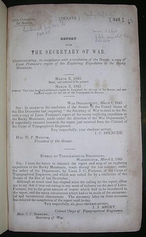
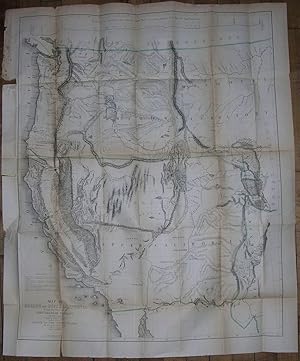
Report of the Exploring Expedition to the Rocky Mountains in the Year 1842, and to Oregon and North California in the Years 1843-'44. 28th Congress, 2d Session, [174].
Verlag: Washington: Gales and Seaton, 1845., 1845
Anbieter: Arader Galleries - AraderNYC, New York, NY, USA
Verkäuferbewertung 5 von 5 Sternen
Erstausgabe
Hardcover. 1st Edition. 8vo., (9 Ľ x 6 inches). (A bit spotted throughout). Large folding lithographed "Map of an Exploring Expedition to the Rocky Mountains in the year 1842 and to Oregon & North California in the years 1843-1844" by Charles Preuss, hand-colored in outline, in rear pocket (evenly browned, one or two short tears at folds); 2 folding lithographed maps; 2 full-page lithographed maps; 22 lithographed plates (a bit spotted). Original publisher's brown cloth, decorated in blind to both covers, the smooth spine in five blind-ruled compartments, gilt-lettered in one and the rest stamped in blind (rebacked, preserving most of the original spine). Provenance: Contemporary manuscript ownership inscription of William L. C. Pennington, a private in the Union Army during the Civil War, to rear pastedown; bookplate of Willard S. Morse (1856-1935) to front pastedown. First edition. Senate issue, with the astronomical and meteorological observations omitted from the House issue and subsequent editions. Fremont's report, written with the help of his wife Jessie Benton, and map "changed the entire picture of the West [and] represented as important a step forward from the earlier western maps of the period as did those of Pike, Long, and Lewis and Clark in their day. [Fremont's map] represented trustworthy direct observation, a new, welcome, and long overdue development in the myth-encrusted cartography of the West. To Fremont and his magnificent map of his Second Expedition all praise. An altogether memorable document in the cartographic history of the West, and for it alone Fremont would deserve to be remembered in history. This map marked not only the end but the beginning of an era" (Wheat). In 1842 Fremont was commissioned to head "a 25-man, four-month expedition to survey and map the region of the emerging Oregon Trail through South Pass on the Continental Divide. A Report of an Exploration . . . between the Missouri River and the Rocky Mountains . . . (1843), the lively, factually detailed government report that Frémont and his wife produced after the journey caught the public imagination: images of Frémont's guide, the then little-known Christopher 'Kit' Carson, riding bareback across the prairie, and Frémont himself, raising a flag on a Rocky Mountain peak, entered the national mythology. "In 1843 Frémont set out on a far more ambitious journey to the Oregon region. Disregarding government orders to return by the same route, he went south to Nevada and, in a dangerous midwinter journey, over the snow-covered Sierra Nevada into Mexican-held California. By the time the expedition returned east across the southern rim of what Frémont defined as the Great Basin, they had completed a bold fourteen-month circuit of the West, traveling 6,475 miles by their own calculations. The Frémonts' account of the journey, A Report of the Exploring Expedition to Oregon and California . . . (1845), enthralled the nation. Skillfully combining adventure, scientific data, and detailed practical information for emigrants, supplemented by a valuable map prepared by expedition cartographer Charles Preuss, it was "monumental in its breadth - a classic of exploring literature" (William H. Goetzmann, Exploration and Empire [1966], p. 248). Powerful propaganda, it stirred Americans to head west, guided, as pioneer Sarah Royce stated, "only by the light of Frémont's Travels" (Pamela Herr for ANB online). Cohen Mapping the West pp.130-133; Field 565; Graff 1436; Howes F-370; Sabin 25845; Streeter sale VI:3131; Wagner-Camp-Becker 115.
-
Narrative of the Exploring Expedition to the Rocky Mountains, in the year 1842, and to Oregon and North Carolina, in the years 1843-44.
Verlag: London: Wiley and Putnam, 1846., 1846
Anbieter: Arader Galleries - AraderNYC, New York, NY, USA
Verkäuferbewertung 5 von 5 Sternen
Erstausgabe
Hardcover. 1st Edition. 8vo., (9 x 5 ľ inches). Fine folding lithographed "Map of the Western and Middle Portions of North America, to Illustrate 'The History of California, Oregon and the Other Countries. On the North West Coast of America' by Robert Greenhow" (one or two short tears at the margins; slight spotting); lithographed frontispiece "The American Falls of Lewis Fork"; 3 lithographed plates (some spotting, pale stain). Later half morocco, cloth boards, the spine in six compartments with five raised bands, gilt-lettered in two, gilt florets in the rest (hinge starting, a bit rubbed). First English edition, first published in the United States the same year. The plates, all by Day & Haghe, are different from those included in other issues: "Hill of Columnar Basalt on the Columbia River"; "Devil's Gate"; and "The Pyramid Lake." This British edition of Fremont, which adds a preface discussing the Oregon dispute, is printed on much better paper than the U.S. editions and the plates were created by one of the prominent lithographic firms in nineteenth-century England, William Day & Louis Haghe, Lithographers to the Queen (Tooley). "John C. Fremont's Report of the Exploring Expedition to the Rocky Mountains.and to Oregon and California can only be described as one of the monumental works of Western Exploration and became the vade mecum of Manifest Destiny. Its words, maps, and pictures paved the way for future waves of overlands culminating in the flood tide of the Gold Rush" (Wheat).
-
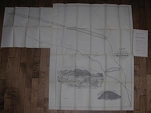
Articles of Association of the Philadelphia and California Mining Company, together with the By-Laws, Lease, Map, &c.
Verlag: Philadelphia: John C. Clark, 1852., 1852
Anbieter: Arader Galleries - AraderNYC, New York, NY, USA
Verkäuferbewertung 5 von 5 Sternen
Erstausgabe
Soft cover. 1st Edition. 4to., (9 5/8 x 5 7/8 inches). Large fine folding lithographed "Map showing The Property of the Philada. & Cala. Mg. Co. Mariposa California" (very slightly toned, slight offsetting to title page). Original publisher's green paper printed wrappers, preserved in a modern cloth portfolio (just touched). First edition. "This company publication includes the terms of a lease from John C. Fremont, a letter from him to the company dated November 10, 1851, and a report of the enterprise's condition and prospects" (Kurutz). The articles stipulate that "the subscribers hereto, having acquired a lease of Six Hundred feet square of land, granted by John Charles Fremont, upon which there is a large quartz vein of gold, situate upon the river Mariposas. and which is deemed to be of great value--the title to which property the subscribers have conveyed to the Trustees of this Company, in trust for the stockholders--offer an opportunity to others to participate in the advantages and profits of said property." In October 1848 Frémont had set out on his ill-fated fourth expedition, "partially financed by St. Louis businessmen eager to locate a central, all-weather railroad route through the Rockies. During the unusually severe winter, the expedition lost its way in the rugged mountains of southern Colorado, and ten men, a third of the expedition, perished in the snow. While Frémont and several reliable men in his party blamed the guide, William S. 'Old Bill' Williams, other members blamed Frémont himself. Despite the tragedy, Frémont pushed on to California, where gold had been discovered at Las Mariposas, a seventy-square-mile tract near Yosemite Valley that he had purchased sight unseen in 1847 for $3,000. Las Mariposas made Frémont rich, but he was not a shrewd businessman. Until he sold it in 1864, its legal entanglements and escalating costs diminished both his profits and his energy" (Pamela Herr for ANB).
-
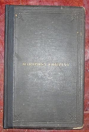
The Mariposa Company, 34 Wall Street, New York.
Verlag: New York: Wm. C. Bryant, 1863., 1863
Anbieter: Arader Galleries - AraderNYC, New York, NY, USA
Verkäuferbewertung 5 von 5 Sternen
Erstausgabe
Hardcover. 1st Edition. 4to., (9 Ľ x 6 Ľ inches). Fine folding lithographed map with hand coloring in full, laid down on linen (some spotting). Original brown publisher's cloth, the front cover titled in gilt and both covers ruled in blind, all edges gilt (rebacked, extremities worn with loss). First edition. In October 1848 Frémont had set out on his ill-fated fourth expedition, "partially financed by St. Louis businessmen eager to locate a central, all-weather railroad route through the Rockies. During the unusually severe winter, the expedition lost its way in the rugged mountains of southern Colorado, and ten men, a third of the expedition, perished in the snow. While Frémont and several reliable men in his party blamed the guide, William S. 'Old Bill' Williams, other members blamed Frémont himself. Despite the tragedy, Frémont pushed on to California, where gold had been discovered at Las Mariposas, a seventy-square-mile tract near Yosemite Valley that he had purchased sight unseen in 1847 for $3,000. Las Mariposas made Frémont rich, but he was not a shrewd businessman. Until he sold it in 1864, its legal entanglements and escalating costs diminished both his profits and his energy" (Pamela Herr for ANB). This volume is a detailed prospectus of Charles Frémont's ill-fated Mariposa Estate Company, which spectacularly failed in 1868, only 6 years after its launch.
-
Report of the Exploring Expedition in the Year 1842 and to Oregon and North California in the Years 1834-1844.
Verlag: Washington: Gales and Seaton, for the Senate of the United States, 1845., 1845
Anbieter: Arader Galleries - AraderNYC, New York, NY, USA
Verkäuferbewertung 5 von 5 Sternen
Erstausgabe
Hardcover. 1st Edition. 8vo., (8 6/8 x 5 4/8 inches). One large lithographic folding map ". of an Exploring Expedition to the Rocky Mountains in the year 1842 and to Oregon & North California in the years 1843-1844" by Charles Preuss with waterways hand-colored in blue tucked into pocket at end (one or two very small holes at folds, lightly browned, but FINE), four lithographic maps, including two folding, and 22 plates (bound with a duplicate of "Devil's Gate", "Hot Spring's Gate" loosely inserted and supplied from a copy of the "House." issue, some occasionally heavy spotting and browning). Original brown cloth (a bit rubbed). "ONE OF THE MONUMENTAL WORKS OF WESTERN EXPLORATION" (Kurutz) First edition, Senate issue, and a NEAR FINE COPY with the astronomical and meteorological observations omitted from the House issue and subsequent editions. Fremont's report, written with the help of his wife Jessie Benton, and map "changed the entire picture of the West [and] represented as important a step forward from the earlier western maps of the period as did those of Pike, Long, and Lewis and Clark in their day. [Fremont's map] represented trustworthy direct observation, a new, welcome, and long overdue development in the myth-encrusted cartography of the West. To Fremont and his magnificent map of his Second Expedition all praise. An altogether memorable document in the cartographic history of the West, and for it alone Fremont would deserve to be remembered in history. This map marked not only the end but the beginning of an era" (Wheat). In 1842 Fremont was commissioned to head "a 25-man, four-month expedition to survey and map the region of the emerging Oregon Trail through South Pass on the Continental Divide. A Report of an Exploration . . . between the Missouri River and the Rocky Mountains . . . (1843), the lively, factually detailed government report that Frémont and his wife produced after the journey caught the public imagination: images of Frémont's guide, the then little-known Christopher "Kit" Carson, riding bareback across the prairie, and Frémont himself, raising a flag on a Rocky Mountain peak, entered the national mythology. "In 1843 Frémont set out on a far more ambitious journey to the Oregon region. Disregarding government orders to return by the same route, he went south to Nevada and, in a dangerous midwinter journey, over the snow-covered Sierra Nevada into Mexican-held California. By the time the expedition returned east across the southern rim of what Frémont defined as the Great Basin, they had completed a bold fourteen-month circuit of the West, traveling 6,475 miles by their own calculations. The Frémonts' account of the journey, A Report of the Exploring Expedition to Oregon and California . . . (1845), enthralled the nation. Skillfully combining adventure, scientific data, and detailed practical information for emigrants, supplemented by a valuable map prepared by expedition cartographer Charles Preuss, it was "monumental in its breadth--a classic of exploring literature" (William H. Goetzmann, Exploration and Empire [1966], p. 248). Powerful propaganda, it stirred Americans to head west, guided, as pioneer Sarah Royce stated, "only by the light of Frémont's Travels" (Pamela Herr for ANB online). Cohen Mapping the West pp.130-133; Field 565; Graff 1436; Howes F-370; Sabin 25845; Streeter sale VI:3131; Wagner-Camp-Becker 115.
-
Report of the Exploring Expedition in the Year 1842 and to Oregon and North California in the Years 1834-1844.
Verlag: Washington: Gales and Seaton, for the Senate of the United States, 1845., 1845
Anbieter: Arader Galleries - AraderNYC, New York, NY, USA
Verkäuferbewertung 5 von 5 Sternen
Erstausgabe
Hardcover. 1st Edition. 8vo., (8 6/8 x 5 4/8 inches). One large lithographic folding map ". of an Exploring Expedition to the Rocky Mountains in the year 1842 and to Oregon & North California in the years 1843-1844" by Charles Preuss with waterways hand-colored in blue loosely inserted at end (pocket for map on inside back cover torn, small holes at folds, one or two short tears with minor loss, browned and creased), four lithographic maps, including two folding, and 21 of 22 plates (without "Outlet of Subterranean River", some occasionally heavy spotting and browning). Original brown cloth (rebacked preserving the original spine, rubbed, shaken). Modern cloth clamshell box. Provenance: Contemporary ownership inscription of Willis Johnson of Waterbury Connecticut, dated December 1848, on the front free endpaper. "ONE OF THE MONUMENTAL WORKS OF WESTERN EXPLORATION" (Kurutz) First edition, Senate issue, with the astronomical and meteorological observations omitted from the House issue and subsequent editions. Fremont's report, written with the help of his wife Jessie Benton, and map "changed the entire picture of the West [and] represented as important a step forward from the earlier western maps of the period as did those of Pike, Long, and Lewis and Clark in their day. [Fremont's map] represented trustworthy direct observation, a new, welcome, and long overdue development in the myth-encrusted cartography of the West. To Fremont and his magnificent map of his Second Expedition all praise. An altogether memorable document in the cartographic history of the West, and for it alone Fremont would deserve to be remembered in history. This map marked not only the end but the beginning of an era" (Wheat). In 1842 Fremont was commissioned to head "a 25-man, four-month expedition to survey and map the region of the emerging Oregon Trail through South Pass on the Continental Divide. A Report of an Exploration . . . between the Missouri River and the Rocky Mountains . . . (1843), the lively, factually detailed government report that Frémont and his wife produced after the journey caught the public imagination: images of Frémont's guide, the then little-known Christopher "Kit" Carson, riding bareback across the prairie, and Frémont himself, raising a flag on a Rocky Mountain peak, entered the national mythology. "In 1843 Frémont set out on a far more ambitious journey to the Oregon region. Disregarding government orders to return by the same route, he went south to Nevada and, in a dangerous midwinter journey, over the snow-covered Sierra Nevada into Mexican-held California. By the time the expedition returned east across the southern rim of what Frémont defined as the Great Basin, they had completed a bold fourteen-month circuit of the West, traveling 6,475 miles by their own calculations. The Frémonts' account of the journey, A Report of the Exploring Expedition to Oregon and California . . . (1845), enthralled the nation. Skillfully combining adventure, scientific data, and detailed practical information for emigrants, supplemented by a valuable map prepared by expedition cartographer Charles Preuss, it was "monumental in its breadth--a classic of exploring literature" (William H. Goetzmann, Exploration and Empire [1966], p. 248). Powerful propaganda, it stirred Americans to head west, guided, as pioneer Sarah Royce stated, "only by the light of Frémont's Travels" (Pamela Herr for ANB online). Cohen Mapping the West pp.130-133; Field 565; Graff 1436; Howes F-370; Sabin 25845; Streeter sale VI:3131; Wagner-Camp-Becker 115.
-
Report of the Exploring Expedition to the Rocky Mountains in the Year 1842 and to Oregon and North California in the Years 1843-44.
Verlag: Washington: Gales and Seaton, for the Senate of the United States, 1845., 1845
Anbieter: Arader Galleries - AraderNYC, New York, NY, USA
Verkäuferbewertung 5 von 5 Sternen
Erstausgabe
Hardcover. 1st Edition. 8vo., (8 6/8 x 5 4/8 inches). One large lithographic folding map ". of an Exploring Expedition to the Rocky Mountains in the year 1842 and to Oregon & North California in the years 1843-1844" by Charles Preuss with waterways hand-colored in blue loosely inserted at end (pocket for map on inside back cover torn one or two small holes at folds, lightly browned, but NEAR FINE), four lithographic maps, including two folding, and 22 plates (some occasionally heavy spotting and browning). Original brown cloth (extremities a bit scuffed). Provenance: Contemporary presentation inscription on the front free endpaper to: "Fred D. Sewall from his friend & brother XY George A. Fairfield". "ONE OF THE MONUMENTAL WORKS OF WESTERN EXPLORATION" (Kurutz) First edition, Senate issue, with the astronomical and meteorological observations omitted from the House issue and subsequent editions. Fremont's report, written with the help of his wife Jessie Benton, and map "changed the entire picture of the West [and] represented as important a step forward from the earlier western maps of the period as did those of Pike, Long, and Lewis and Clark in their day. [Fremont's map] represented trustworthy direct observation, a new, welcome, and long overdue development in the myth-encrusted cartography of the West. To Fremont and his magnificent map of his Second Expedition all praise. An altogether memorable document in the cartographic history of the West, and for it alone Fremont would deserve to be remembered in history. This map marked not only the end but the beginning of an era" (Wheat). In 1842 Fremont was commissioned to head "a 25-man, four-month expedition to survey and map the region of the emerging Oregon Trail through South Pass on the Continental Divide. A Report of an Exploration . . . between the Missouri River and the Rocky Mountains . . . (1843), the lively, factually detailed government report that Frémont and his wife produced after the journey caught the public imagination: images of Frémont's guide, the then little-known Christopher "Kit" Carson, riding bareback across the prairie, and Frémont himself, raising a flag on a Rocky Mountain peak, entered the national mythology. "In 1843 Frémont set out on a far more ambitious journey to the Oregon region. Disregarding government orders to return by the same route, he went south to Nevada and, in a dangerous midwinter journey, over the snow-covered Sierra Nevada into Mexican-held California. By the time the expedition returned east across the southern rim of what Frémont defined as the Great Basin, they had completed a bold fourteen-month circuit of the West, traveling 6,475 miles by their own calculations. The Frémonts' account of the journey, A Report of the Exploring Expedition to Oregon and California . . . (1845), enthralled the nation. Skillfully combining adventure, scientific data, and detailed practical information for emigrants, supplemented by a valuable map prepared by expedition cartographer Charles Preuss, it was "monumental in its breadth--a classic of exploring literature" (William H. Goetzmann, Exploration and Empire [1966], p. 248). Powerful propaganda, it stirred Americans to head west, guided, as pioneer Sarah Royce stated, "only by the light of Frémont's Travels" (Pamela Herr for ANB online). Cohen Mapping the West pp.130-133; Field 565; Graff 1436; Howes F-370; Sabin 25845; Streeter sale VI:3131; Wagner-Camp-Becker 115.
-
Report of the Exploring Expedition in the Year 1842 and to Oregon and North California in the Years 1834-1844.
Verlag: Washington: Blair and Rives, for the House of Representatives, 1845., 1845
Anbieter: Arader Galleries - AraderNYC, New York, NY, USA
Verkäuferbewertung 5 von 5 Sternen
Erstausgabe
Hardcover. 1st Edition. 8vo., (8 6/8 x 5 4/8 inches). One large lithographic folding map ". of an Exploring Expedition to the Rocky Mountains in the year 1842 and to Oregon & North California in the years 1843-1844" by Charles Preuss with waterways hand-colored in blue (one or two shot tears repaired on verso, small holes at folds), four lithographic maps, including two folding, and 22 plates, some tinted (some spotting and browing). Modern red cloth. Provenance: Contemporary ownership inscription of Jacob A. Preston on the title-page; slightly later library inscription on title-page; ink stamp of Henry B. Gardner on title-page. "ONE OF THE MONUMENTAL WORKS OF WESTERN EXPLORATION" (Kurutz) First edition, House of Representatives issue. Fremont's report, written with the help of his wife Jessie Benton, and map "changed the entire picture of the West [and] represented as important a step forward from the earlier western maps of the period as did those of Pike, Long, and Lewis and Clark in their day. [Fremont's map] represented trustworthy direct observation, a new, welcome, and long overdue development in the myth-encrusted cartography of the West. To Fremont and his magnificent map of his Second Expedition all praise. An altogether memorable document in the cartographic history of the West, and for it alone Fremont would deserve to be remembered in history. This map marked not only the end but the beginning of an era" (Wheat). In 1842 Fremont was commissioned to head "a 25-man, four-month expedition to survey and map the region of the emerging Oregon Trail through South Pass on the Continental Divide. A Report of an Exploration . . . between the Missouri River and the Rocky Mountains . . . (1843), the lively, factually detailed government report that Frémont and his wife produced after the journey caught the public imagination: images of Frémont's guide, the then little-known Christopher "Kit" Carson, riding bareback across the prairie, and Frémont himself, raising a flag on a Rocky Mountain peak, entered the national mythology. "In 1843 Frémont set out on a far more ambitious journey to the Oregon region. Disregarding government orders to return by the same route, he went south to Nevada and, in a dangerous midwinter journey, over the snow-covered Sierra Nevada into Mexican-held California. By the time the expedition returned east across the southern rim of what Frémont defined as the Great Basin, they had completed a bold fourteen-month circuit of the West, traveling 6,475 miles by their own calculations. The Frémonts' account of the journey, A Report of the Exploring Expedition to Oregon and California . . . (1845), enthralled the nation. Skillfully combining adventure, scientific data, and detailed practical information for emigrants, supplemented by a valuable map prepared by expedition cartographer Charles Preuss, it was "monumental in its breadth--a classic of exploring literature" (William H. Goetzmann, Exploration and Empire [1966], p. 248). Powerful propaganda, it stirred Americans to head west, guided, as pioneer Sarah Royce stated, "only by the light of Frémont's Travels" (Pamela Herr for ANB online). Cohen Mapping the West pp.130-133; Field 565; Graff 1436; Howes F-370; Sabin 25845; Streeter sale VI:3131; Wagner-Camp-Becker 115.
-
A Report on an Exploration of the Country Lying Between The Missouri River and the Rocky Mountains on the Line of the Kansas and Great Platte Rivers
Verlag: Printed by Order of the United States Senate, Washington D.C., 1843
Anbieter: Arader Galleries - AraderNYC, New York, NY, USA
Verkäuferbewertung 5 von 5 Sternen
Erstausgabe
Soft cover. 1st Edition. 8vo., (8 7/8 x 5 4/8 inches). Single leaf: "Report from the Secretary of War." Tinted lithographic frontispiece and five plates, some tinted (some heavy spotting). Fine large folding map ".to illustrate an exploration of the Country, lying between the Missouri River and the Rocky Mountains, on the line of the Nebraska or Platte River" waterways hand-colored in blue (closed tear near mount). Modern green cloth; blue cloth slipcase and chemise. Provenance: Penciled note on the verso of the first blank stating that this is "Streeter's Copy"; bookplate of Josiah Kirby Lilly (1893-1966), bibliophile and member of the Lilly pharmaceutical dynasty on front paste-down. First edition, issue from the compilation of the Senate documents for the 27th Congress, 3rd Session, with a single leaf (page 243) "Report from the Secretary of War, communicating, in compliance with a resolution of the Senate, a copy of Lieut. Fremont's report of his Exploring Expedition to the Rocky Mountains" outlining the history of the report's reading to the Senate on March 2nd, 1843 and ordering the number of copies to be printed: ". that nine hundred additional copies be furnished for the use of the Senate, and one hundred copies for the use of the Topographical Bureau". "When emigration to the Oregon County became important in 1842, Fremont was sent to survey the route beyond the Mississippi as far as South Pass Wyoming. This route became famous as the "Oregon Trail". Fremont later led two expeditions into Alta California, and he played a major role in the American annexation of California in 1847 and was named governor there. He also led two later overland railroad surveys. In 1850, he became senator from California, and he ran for President as a Republican in 1856. After having served the Union in the Civil War, he was involved in the Southern Pacific Railway scandal, but later served as governor of the Arizona Territory. The text of this report appears in some edition of Fremont's "Report of the exploring expedition to the Rocky Mountains in the year 1842." (Hill). "The expedition was designed by Senator Benton and the expansionist group in Congress to publicize the first main division of the route to Oregon, for though this was well known to the fur traders, the region west of the Missouri was still terra incognita to the general public" (Streeter Sale 3130, describing his copy in original printed wrappers); Graff 1437 (printed wrappers, lacking first leaf); Grolier American Hundred #49: "Made clear the first half of the route to Oregon through the South Pass and cast doubts on the prevailing myth of a great American desert between the Missouri and the Rockies;" Hill 639; Howes F371; Sabin 25843; Wagner-Camp 95.
-
The Mariposa Estate: It's Past, Present and future. Comprising the official report of J. Ross Brown (U.S. Commissioner) Upon its Mineral Resources
Verlag: New York: Russells' American Steam Printing House, 1868., 1868
Anbieter: Arader Galleries - AraderNYC, New York, NY, USA
Verkäuferbewertung 5 von 5 Sternen
Erstausgabe
Hardcover. 1st Edition. 8vo., (8 6/8 x 5 4/8 inches). Large folding chromolithographed map of the Mariposa estate (marginal stain to fist 20 pages). Original plum cloth, gilt (extremities worn with minor loss, unevenly faded to brown, endleaves spotted). First edition. In October 1848 Frémont had set out on his ill-fated fourth expedition, "partially financed by St. Louis businessmen eager to locate a central, all-weather railroad route through the Rockies. During the unusually severe winter, the expedition lost its way in the rugged mountains of southern Colorado, and ten men, a third of the expedition, perished in the snow. While Frémont and several reliable men in his party blamed the guide, William S. "Old Bill" Williams, other members blamed Frémont himself. "Despite the tragedy, Frémont pushed on to California, where gold had been discovered at Las Mariposas, a seventy-square-mile tract near Yosemite Valley that he had purchased sight unseen in 1847 for $3,000. Las Mariposas made Frémont rich, but he was not a shrewd businessman. Until he sold it in 1864, its legal entanglements and escalating costs diminished both his profits and his energy" (Pamela Herr for ANB). This volume is an account of the investigation into the convoluted finances of John Charles Fremont's Mariposa Estate Company which spectacularly failed in 1868, only 6 years after its launch. Sabin 44600.
-
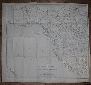
Geographical Memoir upon Upper California, in Illustration of His Map of Oregon and California.
Verlag: Tippin & Streeper, 1849
Anbieter: Arader Galleries - AraderNYC, New York, NY, USA
Verkäuferbewertung 5 von 5 Sternen
Erstausgabe
Hardcover. Zustand: Very Good. 1st Edition. 8vo., (9 x 5 4/8 inches). Folded lithographic map with original hand-color in outline: "Map of Oregon and Upper California from the Surveys of John Charles Frémont and other Authorities. Drawn By Charles Preuss under the Order of the Senate of the United States Washington City 1848" (33 x 26 4/8 inches) (short tears at gutter, with minor loss). Modern quarter green leather. ONE OF THE EARLIEST GRAPHIC ANNOUNCEMENTS OF THE DISCOVERY OF GOLD IN CALIFORNIA First edition, the House issue, of the report of Frémont's third expedition, with the large-scale map rather than the smaller quadrant map. "One of the seminal maps in the history of California exploration and settlement, the Frémont-Preuss map of 1848 is the last of four major cartographic works documenting Lieut. John C. Frémont's two pioneering trans-Mississippi exploration expeditions to Oregon and Northern California in 1843-44 and to the Great Basin and Californian 1844-46. It provides the first depiction of the California region based on scientific topographic surveys, notably expanding contemporary geographic knowledge of the Sierra Nevada and Coast Ranges, and the drainage pattern of the Sacramento and San Joaquin valleys. Published on the eve of the California Gold Rush and statehood, this map also served as a powerful political document that promoted the prevailing American concept of the Manifest Destiny. It was one of the first maps to depict the creation of the Territory of Oregon and the establishment of the Mexican-United States boundary, which was ratified on July 4,1848; the first widely circulated map to announce the location of the discovery of gold deposits along the American and Feather rivers; and it introduced or perpetuated numerous California place names including Kern River, Walker Pass, Owens Lake, and the 'inspired' term, Golden Gate, designating the entrance to San Francisco Bay" (Ehrenberg). Ehrenberg , "California 49: Forty-Nine Maps of California from the Sixteenth Century to the Present" 27:Howes F366; Sabin 25837; Schwartz & Ehrenberg, The Mapping of America, plate 171, p. 278; Wheat, "Books of the California Gold Rush" 78. Catalogued by Kate Hunter.
-
The Exploring Expedition to the Rocky Mountains, Oregon and California, to which is added a Description of the Physical Geography of California. With recent notices of The Gold Rush
Verlag: Buffalo. Geo. H. Derby and Co. 1851, 1851
Anbieter: J. Patrick McGahern Books Inc. (ABAC), Ottawa, ON, Kanada
Verkäuferbewertung 4 von 5 Sternen
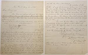
12mo, 19.3cm, 456p., double portrait frontis plate & 2 plate views, publisher's advert on rear paste-down, original brown black cloth, original yellow endpapers, text and plates clean, some restoration on the edges, a near fine bright copy housed in dark blue slipcase, gilt ruled raised bands, double maroon and black leather labels, dark blue black cloth in similar fold over chemise.(cgc). An early edition of several editions published for those considering a westward move, This copy with an interesting Autograph Letter, signed by Frmont, to Charles F[rederick]. Mayer, affixed to verso of first frontispiece. The portraits are of Fremont and of Col. J. J. Albert, Head of the Corps of Topographical Engineers. Graff 1435. Smith 3360. The book is an early edition of several editions published for those considering a westward move. Fremont (1813-1890) was an important figure in nineteenth-century United States, an explorer of the far west, famous in Gold Rush history, one of the first of two U.S. senators from California, and a failed Republican presidential candidate. The recipient of the letter, Charles F. Mayer (1797-1864) was the scion of an important Baltimore family, and was a lawyer and president of the Baltimore & Ohio Railroad. The letter is dated "Washington City, July 27, 1850", and Fremont writes: My dear Sir, have to thank you for the attention of yours of yesterday, which I received last night. Like yourself I think that there are no objections to be entertained to Andrew Smith's Lease, and am glad that you write accordingly to Mr. Robert (?). I shall ask Mr. Robert to let him have it and urge him (Smith) to come out immediately to the ground. The opinion of Mr. Rose (?) will be valuable in England if he is known there, and in any case must have some weight, although it can only be upon the general subject of the validity of California, as mine in particular cannot be known to him. Permit me to remind you of Mr. Webster's opinion although it is unnecessary to do so. I write to both our friends by this mail. I hear that Stockton and Aspinwall are enthusiastic about mining in California gold. Yours truly, J. C. Fremont. Daniel Webster was strongly in favour of acquiring as much California land as was possible and Fremont had known him since Webster was Secretary of State; Andrew Smith was an engineer and the lessee of Golden Mountain during the Gold Rush; [William Henry] Aspinwall (1807-1875) owned Howland & Aspinwall, which popularized the use of clipper ships, and founded, in I848, the Pacific Mail Steamship Company to provide service to California (very timely, indeed, since the Gold Rush began the following year !); [Robert] Stockton (1795-1866) was a naval commodore, notable in the capture of California during the Mexican-American War of 1846-1848. An interesting and very relevant letter.
-
Historically important War-date Autographed Endorsement Signed
Verlag: New York, 1861
Anbieter: Argosy Book Store, ABAA, ILAB, New York, NY, USA
Verkäuferbewertung 5 von 5 Sternen
Signiert
unbound. General Fremont authorizes Major [Simon] Stevens to procure for him a gun shipment of 113 Cases of Rifles -- while they simultaneously participate in the "Hall Carbine Affair." This endorsement was written on the back of a two page handwritten letter from H. Livingstock & Co., Importers and Custom Agents, New York City, August 21, 1861, who notify Fremont, in part: ".Mr. Henry Steven's goes to France, and shall ship to you from there by the Steamer Brewer 113 Cases of Rifles, if not by this vessel he will do so by the next one from Southampton -- the goods to be consigned to Wells, Fargo & Co.In relation to the Rifles, it will be necessary to have an order from the Secretary of the Treasury, to land these free of duty if they are intended for the Government, we do not know how these Cases will be marked -- but the Department can order such are as for yourself to be landed free." Docketed by Gustavus Koerner: Will Major Stevens procure from Washington the necessary permit and find the things right forward - from - Headquarters -- Western Dept -- St. Louis -- August 27, 1861. Endorsed: J.C. Fremont -- Major Genl. Commanding. Note: at the very moment he authorized this gun purchase, Fremont and Stevens were participants involved in the "Hall Carbine Affair" whereby J.P. Morgan financed the purchase of 5000 surplus rifles at $3.50, which were resold back to the government for $22 each. Stevens was the broker who handled this transaction and Fremont was the purchaser! And there's an interesting twist to the story: though referred to as "Major Stevens," Simon Stevens never served in the military. He was appointed to this post on Fremont's staff as a Civilian Forwarding Agent in New York, looking after the Generals' purchases in Europe and the East. Weakness and small tears at the folds; two corners chipped. Very good(-) condition. American military officer, explorer, and first candidate of the Republican Party for the office of President of the United States.
-
Geographical Memoir upon Upper California in Illustration of his Map of Oregon and California.
Verlag: Washington: Tippin & Streeper, 1849., 1849
Anbieter: Arader Galleries - AraderNYC, New York, NY, USA
Verkäuferbewertung 5 von 5 Sternen
Erstausgabe
No Binding. Zustand: Good. 1st Edition. FREMONT, John Charles (1813-1890). Geographical Memoir upon Upper California in Illustration of his Map of Oregon and California. Washington: Tippin & Streeper, 1849. 8vo., (8 4/8 x 5 4/8 inches). Folded lithographic map with original hand-color in outline: "Map of Oregon and Upper California from the Surveys of John Charles Frémont and other Authorities. Drawn By Charles Preuss under the Order of the Senate of the United States Washington City 1848" (35 4/8 x 29 4/8 inches) (detached, browned with some separations at folds). ONE OF THE EARLIEST GRAPHIC ANNOUNCEMENTS OF THE DISCOVERY OF GOLD IN CALIFORNIA First edition, the House issue, of the report of Frémont's third expedition, with the large-scale map rather than the smaller quadrant map. "One of the seminal maps in the history of California exploration and settlement, the Frémont-Preuss map of 1848 is the last of four major cartographic works documenting Lieut. John C. Frémont's two pioneering trans-Mississippi exploration expeditions to Oregon and Northern California in 1843-44 and to the Great Basin and Californian 1844-46. It provides the first depiction of the California region based on scientific topographic surveys, notably expanding contemporary geographic knowledge of the Sierra Nevada and Coast Ranges, and the drainage pattern of the Sacramento and San Joaquin valleys. Published on the eve of the California Gold Rush and statehood, this map also served as a powerful political document that promoted the prevailing American concept of the Manifest Destiny. It was one of the first maps to depict the creation of the Territory of Oregon and the establishment of the Mexican-United States boundary, which was ratified on July 4,1848; the first widely circulated map to announce the location of the discovery of gold deposits along the American and Feather rivers; and it introduced or perpetuated numerous California place names including Kern River, Walker Pass, Owens Lake, and the 'inspired' term, Golden Gate, designating the entrance to San Francisco Bay" (Ehrenberg). Ehrenberg , "California 49: Forty-Nine Maps of California from the Sixteenth Century to the Present" 27:Howes F366; Sabin 25837; Schwartz & Ehrenberg, The Mapping of America, plate 171, p. 278; Wheat, "Books of the California Gold Rush" 78.
-
Report of the Exploring Expedition in the Year 1842 and to Oregon and North California in the Years 1834-1844
Verlag: Washington: Blair and Rives, for the House of Representatives, 1845., 1845
Anbieter: Arader Galleries - AraderNYC, New York, NY, USA
Verkäuferbewertung 5 von 5 Sternen
Erstausgabe
1st Edition. 8vo., (8 6/8 x 5 6 /8 inches). One large lithographic folding map ". of an Exploring Expedition to the Rocky Mountains in the year 1842 and to Oregon & North California in the years 1843-1844" by Charles Preuss with waterways hand-colored in blue in pocket at end (one or two short tears, small holes at folds), four lithographic maps, including two folding, and 22 plates, some tinted (some spotting and browning, a few stains). Near contemporary American deer, red morocco lettering-piece on the spine (a bit rubbed, some surface-wear). "ONE OF THE MONUMENTAL WORKS OF WESTERN EXPLORATION" (Kurutz) First edition, House of Representatives issue. Fremont's report, written with the help of his wife Jessie Benton, and map "changed the entire picture of the West [and] represented as important a step forward from the earlier western maps of the period as did those of Pike, Long, and Lewis and Clark in their day. [Fremont's map] represented trustworthy direct observation, a new, welcome, and long overdue development in the myth-encrusted cartography of the West. To Fremont and his magnificent map of his Second Expedition all praise. An altogether memorable document in the cartographic history of the West, and for it alone Fremont would deserve to be remembered in history. This map marked not only the end but the beginning of an era" (Wheat). In 1842 Fremont was commissioned to head "a 25-man, four-month expedition to survey and map the region of the emerging Oregon Trail through South Pass on the Continental Divide. A Report of an Exploration . . . between the Missouri River and the Rocky Mountains . . . (1843), the lively, factually detailed government report that Frémont and his wife produced after the journey caught the public imagination: images of Frémont's guide, the then little-known Christopher "Kit" Carson, riding bareback across the prairie, and Frémont himself, raising a flag on a Rocky Mountain peak, entered the national mythology. "In 1843 Frémont set out on a far more ambitious journey to the Oregon region. Disregarding government orders to return by the same route, he went south to Nevada and, in a dangerous midwinter journey, over the snow-covered Sierra Nevada into Mexican-held California. By the time the expedition returned east across the southern rim of what Frémont defined as the Great Basin, they had completed a bold fourteen-month circuit of the West, traveling 6,475 miles by their own calculations. The Frémonts' account of the journey, A Report of the Exploring Expedition to Oregon and California . . . (1845), enthralled the nation. Skillfully combining adventure, scientific data, and detailed practical information for emigrants, supplemented by a valuable map prepared by expedition cartographer Charles Preuss, it was "monumental in its breadth--a classic of exploring literature" (William H. Goetzmann, Exploration and Empire [1966], p. 248). Powerful propaganda, it stirred Americans to head west, guided, as pioneer Sarah Royce stated, "only by the light of Frémont's Travels" (Pamela Herr for ANB online). Cohen Mapping the West pp.130-133; Field 565; Graff 1436; Howes F-370; Sabin 25845; Streeter sale VI:3131; Wagner-Camp-Becker 115.

![Bild des Verkäufers für THE EXPEDITIONS OF JOHN CHARLES FRÉMONT [Four volumes] zum Verkauf von Second Story Books, ABAA](https://pictures.abebooks.com/inventory/md/md31783699472.jpg)


![Bild des Verkäufers für Report of the Exploring Expedition to the Rocky Mountains in the Year 1842, and to Oregon and North California in the Years 1843-'44. 28th Congress, 2d Session, [174]. zum Verkauf von Arader Galleries - AraderNYC](https://pictures.abebooks.com/inventory/md/md13582121171.jpg)