Fortifications (21 Ergebnisse)

- Softcover
Anbieter: AwesomeBooks, Wallingford, Vereinigtes KönigreichAwesomeBooks
Verkäufer/-in kontaktierenVerkäufer/-in mit 5 SternenZustand: Gebraucht - Gut
EUR 4,92
EUR 4,81 VersandVersand von Vereinigtes Königreich nach USAAnzahl: 2 verfügbar
Paperback. Zustand: Very Good. Fortress: No. 4 This book is in very good condition and will be shipped within 24 hours of ordering. The cover may have some limited signs of wear but the pages are clean, intact and the spine remains undamaged. This book has clearly been well maintained and looked after thus far. Money back guaran…tee if you are not satisfied. See all our books here, order more than 1 book and get discounted shipping.
- Softcover
Anbieter: Bahamut Media, Reading, Vereinigtes KönigreichBahamut Media
Verkäufer/-in kontaktierenVerkäufer/-in mit 5 SternenZustand: Gebraucht - Gut
EUR 12,00
EUR 8,15 VersandVersand von Vereinigtes Königreich nach USAAnzahl: 2 verfügbar
Zustand: Very Good. Shipped within 24 hours from our UK warehouse. Clean, undamaged book with no damage to pages and minimal wear to the cover. Spine still tight, in very good condition. Remember if you are not happy, you are covered by our 100% money back guarantee.

- Softcover
Anbieter: PBShop.store US, Wood Dale, IL, USAPBShop.store US
Verkäufer/-in kontaktierenVerkäufer/-in mit 5 SternenZustand: Neu
EUR 24,81
Versand nach gratisVersand innerhalb von USAAnzahl: 15 verfügbar
PAP. Zustand: New. New Book. Shipped from UK. Established seller since 2000.
- Softcover
Anbieter: PBShop.store UK, Fairford, GLOS, Vereinigtes KönigreichPBShop.store UK
Verkäufer/-in kontaktierenVerkäufer/-in mit 5 SternenZustand: Neu
EUR 24,56
EUR 3,84 VersandVersand von Vereinigtes Königreich nach USAAnzahl: 15 verfügbar
PAP. Zustand: New. New Book. Shipped from UK. Established seller since 2000.

- Hardcover
Anbieter: PBShop.store US, Wood Dale, IL, USAPBShop.store US
Verkäufer/-in kontaktierenVerkäufer/-in mit 5 SternenZustand: Neu
EUR 34,05
Versand nach gratisVersand innerhalb von USAAnzahl: 15 verfügbar
HRD. Zustand: New. New Book. Shipped from UK. Established seller since 2000.
- Hardcover
Anbieter: PBShop.store UK, Fairford, GLOS, Vereinigtes KönigreichPBShop.store UK
Verkäufer/-in kontaktierenVerkäufer/-in mit 5 SternenZustand: Neu
EUR 32,99
EUR 4,86 VersandVersand von Vereinigtes Königreich nach USAAnzahl: 15 verfügbar
HRD. Zustand: New. New Book. Shipped from UK. Established seller since 2000.

- Softcover
Anbieter: Phatpocket Limited, Waltham Abbey, HERTS, Vereinigtes KönigreichPhatpocket Limited
Verkäufer/-in kontaktierenVerkäufer/-in mit 5 SternenZustand: Gebraucht - Wie neu
EUR 32,73
EUR 12,42 VersandVersand von Vereinigtes Königreich nach USAAnzahl: 1 verfügbar
Zustand: Like New. Used - Like New. This is a reproduction of an out of print title. This book may have occasional imperfections such as missing or blurred pages, poor pictures, errant marks, etc. that were either part of the original artifact, or were introduced by the scanning process. Your purchase helps support Sri Lankan Ch…ildren's Charity 'The Rainbow Centre'. Our donations to The Rainbow Centre have helped provide an education and a safe haven to hundreds of children who live in appalling conditions.

Verlag: 1905., 1905
- Softcover
Anbieter: Loïc Simon, Blaison-Saint Sulpice, FR, FrankreichLoïc Simon
Verkäufer/-in kontaktierenVerkäufer/-in mit 5 SternenZustand: Gebraucht
EUR 14,00
EUR 19,00 VersandVersand von Frankreich nach USAAnzahl: 1 verfügbar
Gravure couleurs dans le Petit Journal "Supplément illustré". Numéro complet.
NASHVILLE, TENNESSEE AND ITS FORTIFICATIONS - AN ORIGINAL ANTIQUE PRINT
NASHVILLE, TENNESSEE AND ITS FORTIFICATIONS - AN ORIGINAL ANTIQUE PRINT
Sprache: Englisch
Verlag: London, 1865
Anbieter: K Books Ltd ABA ILAB, York, YORKS, Vereinigtes KönigreichK Books Ltd ABA ILAB
Verkäufer/-in kontaktierenVerkäufer/-in mit 5 SternenZustand: Gebraucht - Gut
EUR 24,05
EUR 22,77 VersandVersand von Vereinigtes Königreich nach USAAnzahl: 1 verfügbar
No Binding. Zustand: Very Good. An original engraved view. Mounted (matted) and ready to frame. A view of the settlement at Nashville, Tennessee and its fortifications.
Verlag: Imprimerie de Goujon, Paris. 1803., 1803
- Softcover
Anbieter: Loïc Simon, Blaison-Saint Sulpice, FR, FrankreichLoïc Simon
Verkäufer/-in kontaktierenVerkäufer/-in mit 5 SternenZustand: Gebraucht
EUR 39,00
EUR 19,00 VersandVersand von Frankreich nach USAAnzahl: 1 verfügbar
Broché. 108 pages + 6 planches hors-texte. Manques à la couverture.

- Softcover
Anbieter: LiLi - La Liberté des Livres, CANEJAN, FrankreichLiLi - La Liberté des Livres
Verkäufer/-in kontaktierenVerkäufer/-in mit 5 SternenZustand: Gebraucht - Gut
EUR 8,00
EUR 65,00 VersandVersand von Frankreich nach USAAnzahl: 1 verfügbar
Zustand: very good. Le livre peut montrer des signes d'usure dus a une utilisation constante, etre marque, porter des marques d'identification ou presenter plusieurs dommages esthetiques mineurs. vendeur professionnel; envoi soigne en 24/48h.

L'Art Wisigothique et ses survivances
,Josep Puig I Cadafalch / Architecture / Art / urbanisme / construction / structure / charpente / Beaux-arts / abbayes / Cathédrales, Églises / Fortifications
Verlag: Générique
- Softcover
Anbieter: JLG_livres anciens et modernes, Saint Maur des Fossés, FrankreichJLG_livres anciens et modernes
Verkäufer/-in kontaktierenVerkäufer/-in mit 5 SternenZustand: Gebraucht - Sehr gut
EUR 80,00
EUR 18,00 VersandVersand von Frankreich nach USAAnzahl: 1 verfügbar
Zustand: Très bon. Nos envois se font avec suivi, pour tout problème n'hésitez pas à nous contacter pour trouver une solution./ Recherches sur les origines et le développement de l'art en France et en Espagne du IVe au XIIe siècle.
Notice sur le vicomte Dode de La Brunerie, maréchal de France ; par le général Moreau,.
[Fortifications de Paris] Moreau, Auguste (Général Marie Auguste)
Verlag: Paris, Librairie de Firmin-Didot frères, Paris, 1852
- Hardcover
Anbieter: Librairie de l'Avenue - Henri Veyrier, Saint-Ouen, FR, FrankreichLibrairie de l'Avenue - Henri Veyrier
Verkäufer/-in kontaktierenVerkäufer/-in mit 5 SternenZustand: Gebraucht - Gut bis sehr gut
EUR 109,00
EUR 35,00 VersandVersand von Frankreich nach USAAnzahl: 1 verfügbar
Couverture rigide. Zustand: Bon état. In-8 23,5 x 15 cm. Reliure demi-basane, dos lisse orné de filets dorés, en frontispice portrait de Dode de La Brunerie lithographié en noir avec serpente par Léon Noël d'aprés Larivière, 169 pp. Dos frotté et passé, avec accroc en tête, intérieur frais. Ouvrage peu courant. Général et maréch…al de France, Guillaume Dode de la Brunerie (1775-1851), officier du génie, se distingue dans toutes les campagnes de la Révolution et de l'Empire. Nommé en 1840 président du conseil des fortifications, il dirige la construction des fortifications de Paris, dite enceinte de Thiers.
PLAN OF THE TOWN AND HARBOUR OF MAHON, ST PHILIP'S CASTLE, AND ITS FORTIFICATIONS - Original Antique Hand-Coloured Copper-engraved Plan
PLAN OF THE TOWN AND HARBOUR OF MAHON, ST PHILIP'S CASTLE, AND ITS FORTIFICATIONS - Original Antique Hand-Coloured Copper-engraved Plan
Sprache: Englisch
Anbieter: K Books Ltd ABA ILAB, York, YORKS, Vereinigtes KönigreichK Books Ltd ABA ILAB
Verkäufer/-in kontaktierenVerkäufer/-in mit 5 SternenZustand: Gebraucht - Gut
EUR 144,31
EUR 22,77 VersandVersand von Vereinigtes Königreich nach USAAnzahl: 1 verfügbar
No Binding. Zustand: Very Good. Hand-coloured Copper engraved plan, mounted (matted) and ready to frame in the UK, but for overseas customers it would probably be unmounted as it would be too large to post. Colouring not contemporary, but delicately and expertly done. No date, but printed c 1750. Plan of the town showing the Sta…r fort of St Philip's with its star-shaped fortifications, with the explanation inset. There is slight loss to the plan, a section of perhaps one inch missing from the left-hand side, with no appreciable loss to the depiction of the town and harbour. This accounts for the low price of the plan. Printed for Mr Tindal's continuation of Mr Rapin's History of England. Basire (illustrator).
Relation de la surprise de Berg-Op-Zoom, le 8 et le 9 mars 1814, avec un précis du blocus et des évènements qui l'ont amené, précédée d'une notice historique et topographique militaire, et d'un plan croquis.
Legrand, (Chevalier, Colonel au Corps Royal du Génie, Directeur Des Fortifications.)
Verlag: Chez Magimel, Anselin et Pochard, Bruxelles, 1816
Anbieter: Histoire et Société, Bordeaux, FrankreichHistoire et Société
Verkäufer/-in kontaktierenVerkäufer/-in mit 5 SternenVerbandsmitglied: ILAB
Zustand: Gebraucht
EUR 200,00
EUR 5,60 VersandVersand von Frankreich nach USAAnzahl: 1 verfügbar
Petit in-8, reliure demi-percaline prune du XIXe, plats marbrés, titre doré au dos estompé, [4]-132 p. Plan-croquis dépliant de la place de Berg-Op-Zoom. A la fin de l'année 1813, les troupes françaises avaient reflué des villes au nord des Pays-Bas, gagné par une insurrection générale. Berg-Op-Zoom, petite ville fortifiée dans…l'ouest du nord-Brabant, en Hollande, stratégique par sa position entre Anvers et la Hollande, était commandée depuis 1810 par le général Bizanet. La garnison française réussit l'exploit de vaincre, après des combats acharnés dans la ville les 8 et 9 mars 1814, les quatre colonnes du général britannique Graham. Bizanet resta maître de la ville jusqu'à l'abdication de Napoléon et la signature de la paix en avril 1814. Dos insolé, titre effacé, petit manque de percaline sur les plats, bon intérieur, bien complet du plan dépliant. Peu fréquent.(B50).PHOTOS NUMERIQUES DISPONIBLES PAR EMAIL SUR SIMPLE DEMANDE-DIGITAL PHOTOGRAPS MAY BE AVAILABLE ON REQUEST Size: 13 x 20,5.
- Hardcover
Anbieter: Herman H. J. Lynge & Søn ILAB-ABF, Copenhagen, DänemarkHerman H. J. Lynge & Søn ILAB-ABF
Verkäufer/-in kontaktierenVerkäufer/-in mit 4 SternenZustand: Gebraucht
EUR 620,12
Versand nach gratisVersand von Dänemark nach USAAnzahl: 1 verfügbar
Paris, L'Imprimerie Royale, 1821-26. Bound in 6 contemp. hcalf. Richly gilt spines. Stamp on title-pages. In all ca.1600 pp. Each issue separately paginated. With folded tables and 69 large folded engraved plates. Clean and fine.

- Karte
Anbieter: Geographicus Rare Antique Maps, Brooklyn, NY, USAGeographicus Rare Antique Maps
Verkäufer/-in kontaktierenVerkäufer/-in mit 4 SternenZustand: Gebraucht
EUR 1.412,07
EUR 14,86 VersandVersand innerhalb von USAAnzahl: 1 verfügbar
Good. Toning. Wear along original fold lines. Verso repairs at fold intersections. Closed margin tear repaired on verso. Size 19 x 22 Inches. An engrossing 1922 Ottoman Turkish military and topographic map of the Dardanelles, produced by the Erkan-? Harbiye-i Umumiye Matbaas? It highlights fortifications, lines of communication,… and other essential military information constructed just before and during World War I (1914 - 1918), preparations that would pay off during the Gallipoli Campaign in 1915. A Closer Look Coverage includes the southern part of Erdine Province and much of Çanakkale Province, including most of the Gallipoli Peninsula. The map's title comes from the Sultaniyeh Castle, also known as the Çimenlik Castle, a 15th-century fortification on the Asian side of the Dardanelles built at the narrowest point. Across from it, on the European side, is the Kilitbahir Castle, also built in the 15th century. Although old, both castles were upgraded over the centuries to provide a nearly impregnable defense for the Dardanelles and approaches to Istanbul. Aside from topographic features like elevation, waterways, and terrain, settlements and military installations, including fortifications, roads, railways, and other lines of communication, are labeled. Anchorages and lighthouses are also indicated. Historical Context After belatedly recognizing that their defenses along the Dardanelles were out of date, the Ottomans rapidly fortified both shores in the years before the 1915 Gallipoli Campaign. These efforts continued throughout the campaign, and ranged from smaller-scale works like trenches to fortified gun batteries. Although the length of the Dardanelles was heavily fortified and these waters did see naval engagements, most of the fighting took place slightly to the south, around Seddülbahir (the 'Walls of the Sea') at the tip of the Gallipoli Peninsula. The Gallipoli Campaign The Gallipoli Campaign was an ambitious but ultimately ineffective attempt by Entente Powers to weaken the Ottoman Empire and knock it out of the war. The Ottomans were believed to be very weak given their losses in the recent Italo-Turkish War (1911 - 1912) and the First Balkan War (1912 - 1913). Aside from weakening the Ottoman military threat, a secure supply line to the Black Sea would be a major advantage against the Axis. Initially, the Entente attempted to break through the Dardanelles and Bosporus using naval power alone, but this proved impossible. Afterward, the Entente turned to an amphibious operation, but planning suffered from poor intelligence and an underestimation of the quality and quantity of Ottoman forces. In fact, the Ottoman troops tasked with defending Gallipoli were highly motivated (they were, in essence, defending their capital) and commanded by an experienced corps, including both Turkish and German officers. Perhaps most importantly, the Entente ran into significant delays in disembarking troops, giving defenders weeks to prepare after the invasion plan had lost its element of surprise. Landing in late April 1915, the Entente troops, including large contingents of Australian, New Zealander (ANZAC), and Indian troops, quickly established beachheads at the tip of the Gallipoli Peninsula around Seddülbahir (Cape Helles). Further up the peninsula, however, they ran into heavily entrenched Turkish troops defending high ground, armed with machine guns and artillery. Over the next several months, both sides threw in hundreds of thousands of troops, along with battleships, submarines, airplanes, and other resources, to push the enemy trenches and effect a breakthrough. In the end, though, the battle proved a stubborn stalemate. Given the difficulties of securing and supplying their beachhead, the Entente position was more tenuous, leading to an evacuation in November-January. Military historians debate the significance of the Gallipoli Campaign, but there is no doubt that the Entente failed to achieve their objectives. Not o.

Environs et fortifications de Paris, annee 1841.
1841 Langlois Map of Paris, Focusing on Walls and Fortifications
- Karte
Anbieter: Geographicus Rare Antique Maps, Brooklyn, NY, USAGeographicus Rare Antique Maps
Verkäufer/-in kontaktierenVerkäufer/-in mit 4 SternenZustand: Gebraucht
EUR 1.815,52
EUR 14,86 VersandVersand innerhalb von USAAnzahl: 1 verfügbar
Average. Toning along fold lines. Foxing throughout. Repaired tears at left margin. Size 22.5 x 18 Inches. An impressive, hand-colored c. 1841 representation of Paris and environs by Hyacinthe Langlois. The map highlights the city's defenses, in particular the 'Thiers Wall' constructed between 1841 and 1846. A Closer Look Covera…ge includes the entirety of Paris within the proposed walls and the surrounding Département de la Seine, which is shaded in pink. The wider area, beginning from the green shaded lines, was part of the Département de Seine-et-Oise, which completely surrounded the Département de la Seine, and the nearby Département de Seine et Marne. Surrounding the city walls are a string of forts. Familiar sites in the environs of Paris are clearly visible, such as the Bois de Boulogne and Versailles. The text of the Law of April 4, 1841, which allocated funds for the fortifications, is included below the map, as are statistics that discuss features of the walls in greater detail. A legend at top left explains abbreviations and symbols while a list at top-right provides statistics about the département de la Seine. The Fortification of Paris Prior to the Napoleonic Wars, Paris was considered safe from invasion due to border defenses and was thought too large to fortify in any case. But the easy seizure of the capital by foreign enemies during the 1814 Battle of Paris caused French military thinkers to reconsider these assumptions. Under the July Monarchy (1830 - 1848), a broad network of walls and forts was conceived that were intended to make Paris impregnable. The project was met with immediate opposition, some of which claimed that the walls were not defensive, but rather intended to control Parisians in the event of an anti-monarchal rebellion (an assumption that proved prescient). Nonetheless, under a plan prepared by Marshal General Jean-de-Dieu Soult (1759 - 1861), construction began in 1841. The fortifications, named the Thiers Wall after the French Prime Minister at the time, Adolphe Theirs (1797 - 1877), were completed at enormous expense in 1844, with some additions made through 1846. The walls were 33 kilometers long and consisted of 94 bastions, 17 gates, 23 minor road crossings, and eight railroad gates. Unfortunately for Parisians, the walls were not able to fend off an invading force during the Franco-Prussian War (1870 - 1871), as the Prussians had state-of-the-art artillery that could fire from well beyond the range of French defensive guns. Although the walls held, the Prussians were able to besiege the city and hammer it continually with artillery. Losses on the battlefield elsewhere removed all hope of a relief force breaking the siege and Paris surrendered in late January 1871. Afterwards, a conservative and monarchist government was elected, headed by none other than Adolphe Thiers. Leftists in Paris were irate at this turn of events and rose up in March 1871 to oust the national government. Thus, Paris was once again besieged, this time by the French national government, with Prussian support, against the communards of the Paris Commune. Lacking much in the way of heavy weapons, the communards were unable to prevent the breach of the city walls by government forces, which came on May 21 and was followed by the notorious 'semaine sanglante.' By 1919, advancements in military technology made clear that the walls were obsolete, leading to their complete deconstruction by 1929 and replacement with the Boulevard Périphérique. Publication History and Census This map was prepared by Hyacinthe Langlois and printed by Kaeppelin et Cie in Paris. The author does not appear to refer to Eustache-Hyacinthe Langlois, a celebrated painter and engraver who had died four years before this map's publication and who was based in Rouen. The map is quite rare; its only listing in the OCLC is with the Getty Research Institute in Los Angeles, though that example lists a different printer (Imprimerie Simon). Refer.
 Weitere Bilder
- Erstausgabe
- Karte
Anbieter: Geographicus Rare Antique Maps, Brooklyn, NY, USAGeographicus Rare Antique Maps
Verkäufer/-in kontaktierenVerkäufer/-in mit 4 SternenZustand: Gebraucht
EUR 706,03
EUR 14,86 VersandVersand innerhalb von USAAnzahl: 1 verfügbar
1st Edition. Very good. Dissected and laid down on original linen as issued. Original hand color. Minor soiling; some fraying of linen at a juncture of folds, else excellent. Size 16 x 22 Inches. This is a scarce, separately-issued c. 1770 Jean Lattré map of the town, port and peninsula of Gibraltar. This eastern-oriented map is… richly detailed, showing the remarkable and forbidding topography of the peninsula and its fortifications. The map shows the positions held by the Spanish and the British during their long stalemate following the 1727 Spanish siege of Gibraltar. Lattré appears to have produced this map as a separate issue near the end of the Seven Years' War (1756 - 1763), coinciding with Spain's entrance to that conflict. Although the war ended without any action at Gibraltar, it would have been considered a possible theater of engagement. State of the Map This third state of the map we suspect to have been printed in the 1770s, following British modernization of the port's defenses. This state includes significant additional British fortification, and a 'Supplement' added to catalogue these changes. It may have been printed as late as Spain's 1779 declaration of war on Britain: since Spain's primary aim in entering that war was the recapture of Gibraltar, the update of this map would have been timely. Publication History and Census This map is rare, and it is not well catalogued. As a consequence of it being an undated, separately issued map, there is no clear agreement on its dating among institutional collections. The map was listed among the offerings of Lattré's shop in the catalogue accompanying his 1762 Atlas moderne , so an approximate date of 1762 is warranted for the first printing. Other Examples We have identified four states: c. 1762 First state (see copy at the Institut Cartographic i Geologic de Catalunya, misdated 1770.) Lacks names for bodies of water, depth soundings. c. 1763 Second state (see Instituto Geographico Nacional: Adds 'Mer Mediterranee,' Partie de la Baye de Gibraltar,' depth soundings and anchorage off northwest coast. Lines of fire from Spanish batteries and fortifications to the North have also been added. c. 1770 (?) This state (our example) has significant additions. English fortifications on the southern heights of the peninsula are noted, as well as military positions throughout. A supplemental legend has been added to the lower right, detailing the newly added features. A scale has been added, and the notation 'rochers inaccessibles' is included on the cliffs dominating the eastern coast. More anchorages are also marked facing the western approaches to the port. c. 1783 (Princeton Historic Map Division, Special Collections, Firestone Library, misdated c. 1756) This state adds significant detail pertaining directly to the Grand Assault of the Great Siege of Gibraltar, including depictions of the floating batteries devised by French engineer Jean Le Michaud d'Arçon, so this state could not have been produced prior to 1782, and probably was not produced prior to the conclusion of the siege in 1783. There are only six examples of the map in OCLC: two of which are state 3, and one of which is state 4. (others undetermined). Not in OCLC, but in their online collections, are the state 1 at Cartographic i Geologic de Catalunya and the state 2 example at the Instituto Geographico Nacional. An edition by Treuttel et Wurtz was printed in Strasbourg, copied from the fourth state of the Lattré. References: OCLC 956285559.
 Weitere Bilder
- Karte
Anbieter: Geographicus Rare Antique Maps, Brooklyn, NY, USAGeographicus Rare Antique Maps
Verkäufer/-in kontaktierenVerkäufer/-in mit 4 SternenZustand: Gebraucht
EUR 958,19
EUR 14,86 VersandVersand innerhalb von USAAnzahl: 1 verfügbar
Very good. On original linen. Accompanied by original slipcase. Size 28.25 x 40.25 Inches. This is a striking 1844 large-scale July Monarchy (1830 - 1848) map of Paris, France. The map is surrounded by 34 vignette illustrations of important sites - significant as the only edition of this map to feature these. The map predates th…e Haussmann Renovations (1853 - 1870) but celebrates the 1844 completion of the Thiers Wall and Ring Forts - likely the reason for this deluxe vignette edition. It additionally features profile and vignette illustrations of important sites throughout the map itself. The Fortification of Paris This map exhibits the Theirs Wall shortly after it was completed in 1844. Shocked by the seizure of Paris by foreign enemies during the 1814 Battle of Paris, the French King at the time, Louis-Philippe (1830 - 1848), conceived of a broad network of walls and forts he believed would make Paris impregnable. The project was met with immediate opposition, some of which claimed that the walls were not defensive, but rather intended to control Parisians in the event of an anti-monarchal rebellion. Nonetheless, under a plan prepared by Marshal General Jean-de-Dieu Soult (1759 - 1861), construction began in 1841. The completed fortifications, named the Thiers Wall after the French Prime Minister at the time, Adolphe Theirs (1797 - 1877), were, at enormous expense, completed in 1844. The walls were 33 kilometers long and consisted of 94 bastions, 17 gates, 23 minor road crossings, and eight railroad gates. By 1919, advancements in military technology made the walls obsolete, leading them to be fully deconstructed by 1929 and replaced with the Boulevard Périphérique. Publication History and Census This map was issued by Auguste Logerot c. 1844. We have seen other editions of the base map, some dated, some not, as early as 1843 and as late as 1847. We have never before encountered an example with the surrounding pictorial vignettes - making this example both exceptionally beautiful and unique. Most catalogers attribute the engraving of this map to Charles Dyonnet and the vignettes to Maillard and A. Toussaint, but we see these names nowhere on this map.
 Weitere Bilder
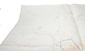
Proekt ukrepleniya g. Varna (i.e.: "A project of the fortification of town of Varna"). Dopol. Otd. Sht. Kapitan (Stabskapitän, staff captain) Sedel'nikov.
"FORTIFICATION OF VARNA (ODESSA) BULGARIA - OROGRAPHIC MANUSCRIPT MAP WITH 19 FORTIFICATIONS.
Anbieter: Herman H. J. Lynge & Søn ILAB-ABF, Copenhagen, DänemarkHerman H. J. Lynge & Søn ILAB-ABF
Verkäufer/-in kontaktierenVerkäufer/-in mit 4 SternenZustand: Gebraucht
EUR 1.378,04
Versand nach gratisVersand von Dänemark nach USAAnzahl: 1 verfügbar
Varna 1888-89. 131 x 126 cm. joined by 4 sheets. Large manuscript surveying map of the fortress of Varna and its vicinity of with contour lines and defensive fortresses, including the fortified lines along the Black Sea coast. Depicting in all 19 defensive installations in all directions from Varna. Surveyed by the Russian capta…in, Kapitan Scrodel'uikov. Pen and ink with watercolour. With scale. On good thick paper. With 4 small punched holes (stars).


