Gesamtpreis (1 Artikel Artikel):
Versandziel:

f w danson (1 Ergebnisse)
Direkt zu den wichtigsten Suchergebnissen
Suchfilter
Produktart
- Alle Product Types
- Bücher (Keine weiteren Ergebnisse entsprechen dieser Verfeinerung)
- Magazine & Zeitschriften (Keine weiteren Ergebnisse entsprechen dieser Verfeinerung)
- Comics (Keine weiteren Ergebnisse entsprechen dieser Verfeinerung)
- Noten (Keine weiteren Ergebnisse entsprechen dieser Verfeinerung)
- Kunst, Grafik & Poster (Keine weiteren Ergebnisse entsprechen dieser Verfeinerung)
- Fotografien (Keine weiteren Ergebnisse entsprechen dieser Verfeinerung)
- Karten (1)
- Manuskripte & Papierantiquitäten (Keine weiteren Ergebnisse entsprechen dieser Verfeinerung)
Zustand Mehr dazu
- Neu (Keine weiteren Ergebnisse entsprechen dieser Verfeinerung)
- Wie Neu, Sehr Gut oder Gut Bis Sehr Gut (Keine weiteren Ergebnisse entsprechen dieser Verfeinerung)
- Gut oder Befriedigend (1)
- Ausreichend oder Schlecht (Keine weiteren Ergebnisse entsprechen dieser Verfeinerung)
- Wie beschrieben (Keine weiteren Ergebnisse entsprechen dieser Verfeinerung)
Einband
- alle Einbände
- Hardcover (Keine weiteren Ergebnisse entsprechen dieser Verfeinerung)
- Softcover (Keine weiteren Ergebnisse entsprechen dieser Verfeinerung)
Weitere Eigenschaften
- Erstausgabe (Keine weiteren Ergebnisse entsprechen dieser Verfeinerung)
- Signiert (Keine weiteren Ergebnisse entsprechen dieser Verfeinerung)
- Schutzumschlag (Keine weiteren Ergebnisse entsprechen dieser Verfeinerung)
- Angebotsfoto (1)
Sprache (1)
Preis
- Beliebiger Preis
- Weniger als EUR 20 (Keine weiteren Ergebnisse entsprechen dieser Verfeinerung)
- EUR 20 bis EUR 45 (Keine weiteren Ergebnisse entsprechen dieser Verfeinerung)
- Mehr als EUR 45
Gratisversand
- Kostenloser Versand nach USA (Keine weiteren Ergebnisse entsprechen dieser Verfeinerung)
Land des Verkäufers
Verkäuferbewertung
-
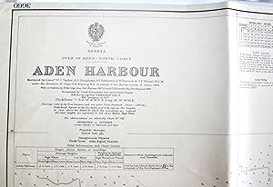
British Admiralty Chart No. 3660 Arabia - Gulf of Aden North Coast - Aden Harbour
Verlag: British Admiralty, London, 1949
Anbieter: Dendera, London, Vereinigtes Königreich
Verkäuferbewertung 5 von 5 Sternen

Karte
EUR 691,46
EUR 29,19 Versand
Versand von Vereinigtes Königreich nach USAAnzahl: 1 verfügbar
In den WarenkorbNo Binding. Zustand: Very Good. B/w chart with red hand colouring 103x70cm. Very good, folded. First published on 19 Nov 1907, the latest edition stated is 11 June 1948 following shortly after the Aden Riots, with small corrections up to 1949. This beautifully drawn map on a Natural Scale of 1:6,120 shows an important part of the coast of the Aden Peninsula inland as far as Gold Mohur Valley (SE corner), with relief, and several key locations clearly laid out. These include Government House, the Port Trust, Signal Station, Police Commissioner, Sheba Camp, Cunningham Market, Police Lines, Steamer Point, named wharves, factories, yards, shipping line offices and other installations, gardens, churches, cemeteries, named hills, etc down to the level of the Notice Board outside of Sheba Camp. Captions for the Harbour itself demarcate prohibited anchorages and anchorage for country craft, varying depths of dredging the Inner Harbour done in 1945, etc.