Gesamtpreis (1 Artikel Artikel):
Versandziel:

elisha robinson (10 Ergebnisse)
Direkt zu den wichtigsten Suchergebnissen
Suchfilter
Produktart
- Alle Product Types
- Bücher (10)
- Magazine & Zeitschriften (Keine weiteren Ergebnisse entsprechen dieser Verfeinerung)
- Comics (Keine weiteren Ergebnisse entsprechen dieser Verfeinerung)
- Noten (Keine weiteren Ergebnisse entsprechen dieser Verfeinerung)
- Kunst, Grafik & Poster (Keine weiteren Ergebnisse entsprechen dieser Verfeinerung)
- Fotografien (Keine weiteren Ergebnisse entsprechen dieser Verfeinerung)
- Karten (Keine weiteren Ergebnisse entsprechen dieser Verfeinerung)
- Manuskripte & Papierantiquitäten (Keine weiteren Ergebnisse entsprechen dieser Verfeinerung)
Zustand Mehr dazu
- Neu (8)
- Wie Neu, Sehr Gut oder Gut Bis Sehr Gut (Keine weiteren Ergebnisse entsprechen dieser Verfeinerung)
- Gut oder Befriedigend (1)
- Ausreichend oder Schlecht (Keine weiteren Ergebnisse entsprechen dieser Verfeinerung)
- Wie beschrieben (1)
Einband
Weitere Eigenschaften
- Erstausgabe (Keine weiteren Ergebnisse entsprechen dieser Verfeinerung)
- Signiert (Keine weiteren Ergebnisse entsprechen dieser Verfeinerung)
- Schutzumschlag (Keine weiteren Ergebnisse entsprechen dieser Verfeinerung)
- Angebotsfoto (3)
Sprache (2)
Preis
- Beliebiger Preis
- Weniger als EUR 20 (Keine weiteren Ergebnisse entsprechen dieser Verfeinerung)
- EUR 20 bis EUR 45
- Mehr als EUR 45
Gratisversand
Land des Verkäufers
Verkäuferbewertung
-

In What Respects May the Administration of the Poor Law Be Improved A Paper Read at Bristol, at the Request of the Council of the Social Science Association Classic Reprint
Anbieter: PBShop.store US, Wood Dale, IL, USA
Verkäuferbewertung 5 von 5 Sternen

PAP. Zustand: New. New Book. Shipped from UK. Established seller since 2000.
-
In What Respects May the Administration of the Poor Law Be Improved A Paper Read at Bristol, at the Request of the Council of the Social Science Association Classic Reprint
Anbieter: PBShop.store UK, Fairford, GLOS, Vereinigtes Königreich
Verkäuferbewertung 5 von 5 Sternen
EUR 23,90
EUR 3,80 Versand
Versand von Vereinigtes Königreich nach USAAnzahl: 15 verfügbar
In den WarenkorbPAP. Zustand: New. New Book. Shipped from UK. Established seller since 2000.
-

Vermont
Anbieter: Ria Christie Collections, Uxbridge, Vereinigtes Königreich
Verkäuferbewertung 5 von 5 Sternen
EUR 22,66
EUR 13,85 Versand
Versand von Vereinigtes Königreich nach USAAnzahl: Mehr als 20 verfügbar
In den WarenkorbZustand: New. In.
-

Vermont: A Study of Independence
Anbieter: Ria Christie Collections, Uxbridge, Vereinigtes Königreich
Verkäuferbewertung 5 von 5 Sternen
EUR 23,58
EUR 13,85 Versand
Versand von Vereinigtes Königreich nach USAAnzahl: Mehr als 20 verfügbar
In den WarenkorbZustand: New. In.
-

Vermont
Anbieter: Ria Christie Collections, Uxbridge, Vereinigtes Königreich
Verkäuferbewertung 5 von 5 Sternen
EUR 33,32
EUR 13,85 Versand
Versand von Vereinigtes Königreich nach USAAnzahl: Mehr als 20 verfügbar
In den WarenkorbZustand: New. In.
-

Contemporary Australian Plays: The Hotel Sorrento; Dead White Males; Two; The 7 Stages of Grieving; The Popular Mechanicals (Play Anthologies)
Anbieter: Ria Christie Collections, Uxbridge, Vereinigtes Königreich
Verkäuferbewertung 5 von 5 Sternen
EUR 42,19
EUR 13,85 Versand
Versand von Vereinigtes Königreich nach USAAnzahl: Mehr als 20 verfügbar
In den WarenkorbZustand: New. In.
-
Contemporary Australian Plays: Hotel Sorrento/Dead White Males/Tow/the 7 Stages of Grieving/the Popular Mechanicals
Anbieter: Revaluation Books, Exeter, Vereinigtes Königreich
Verkäuferbewertung 5 von 5 Sternen
EUR 50,42
EUR 11,56 Versand
Versand von Vereinigtes Königreich nach USAAnzahl: 2 verfügbar
In den WarenkorbPaperback. Zustand: Brand New. 320 pages. 7.50x5.00x1.00 inches. In Stock.
-

Atlas of the City of Detroit and Suburbs: Embracing Portions of Hamtramck, Springwells and Greenfield Townships, Wayne County, Mich. From Offical Reco
Sprache: Englisch
Verlag: Creative Media Partners, LLC Sep 2021, 2021
ISBN 10: 1014927803 ISBN 13: 9781014927804
Anbieter: AHA-BUCH GmbH, Einbeck, Deutschland
Verkäuferbewertung 5 von 5 Sternen
Taschenbuch. Zustand: Neu. Neuware.
-
Atlas Of The City Of Cincinnati, Ohio; From Official Records, Private Plans & Actual Surveys
Verlag: E. Robinson, New York, 1884
Anbieter: The First Edition Rare Books, LLC, Cincinnati, OH, USA
Verbandsmitglied: ABAA ILAB IOBA MWABA
Verkäuferbewertung 5 von 5 Sternen
Paper. Zustand: Very good. Mount Adams and Eden Park, Plate 8 from the Atlas Of The City of Cincinnati, Ohio, published in 1884 by Elisha Robinson and R.H. Pidgeon of New York. (illustrator). Wards 3, 4, & 6 / Section 12 & 18. The hand-colored, double-page sheets were engraved by A.H. Mueller of Philadelphia, lithography by the firm of F. Bourquin of Philadelphia. Individual plates measure 29" x 20", with notable wear along margins, previously folded along center line. Right margin trimmed, closed tears along left edge. Delicate condition along center hinge. A few thumb prints along edge. Each plate shows the notable landowners, the major throughways, rivers and plot maps for future residential developments. A great piece for framing. This plate features the following neighborhoods in Hamilton County, Ohio: Mt. Adams, Eden Park, and downtown Cincinnati. Major roadways include Eggleston Avenue, Eastern Avenue, Broadway, Sycamore St., and Gilbert Avenue. Notable landmarks include the Highland House, Church of the Holy Cross - Immaculata Parish, and the Ohio River.
-
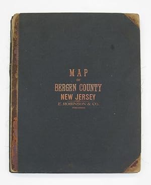
Map of Bergen County with a Portion of Passaic Co.; Compiled from the Geological Survey of New Jersey, Official Maps Private Plans and Actual Surveys by and under the direction of E. Robinson
Verlag: E. Robinson & Co, New York, 1902
Anbieter: Argosy Book Store, ABAA, ILAB, New York, NY, USA
Verkäuferbewertung 5 von 5 Sternen
Mueller, A.H. (illustrator). Wall map. Color lithograph with hand coloring. Library format in four pieces, mounted on three boards as issued, 18 x 14 1/2 inches, if joined, 53" x 67.5". This impressive map of Bergen County, New Jersey depicts the county's townships and boroughs in remarkably vivid colors. A short newsprint text praising the map has been glued onto its lower right-hand portion. The map is highly informational and depicts railroads both electric and steam, public roads, and elevations. The index also includes churches, schools, cemeteries, and meadows. The map is in good condition, with some tears along the folds, a crease in the lower left portion, and minor browning throughout. The coloring, however, remains exceptionally brilliant. Elisha Robinson (1832-1912) published a number of detailed, general purpose maps, including comprehensive atlases of Kings County, New York and Essex County, New Jersey. This library edition was printed in Philadelphia by A.H. Mueller.