Gesamtpreis (1 Artikel Artikel):
Versandziel:

dheulland (22 Ergebnisse)
Direkt zu den wichtigsten Suchergebnissen
Suchfilter
Produktart
- Alle Product Types
- Bücher (8)
- Magazine & Zeitschriften (Keine weiteren Ergebnisse entsprechen dieser Verfeinerung)
- Comics (Keine weiteren Ergebnisse entsprechen dieser Verfeinerung)
- Noten (Keine weiteren Ergebnisse entsprechen dieser Verfeinerung)
- Kunst, Grafik & Poster (6)
- Fotografien (Keine weiteren Ergebnisse entsprechen dieser Verfeinerung)
- Karten (8)
- Manuskripte & Papierantiquitäten (Keine weiteren Ergebnisse entsprechen dieser Verfeinerung)
Zustand Mehr dazu
- Neu (2)
- Wie Neu, Sehr Gut oder Gut Bis Sehr Gut (2)
- Gut oder Befriedigend (6)
- Ausreichend oder Schlecht (Keine weiteren Ergebnisse entsprechen dieser Verfeinerung)
- Wie beschrieben (12)
Einband
Weitere Eigenschaften
- Erstausgabe (Keine weiteren Ergebnisse entsprechen dieser Verfeinerung)
- Signiert (Keine weiteren Ergebnisse entsprechen dieser Verfeinerung)
- Schutzumschlag (Keine weiteren Ergebnisse entsprechen dieser Verfeinerung)
- Angebotsfoto (19)
Sprache (2)
Gratisversand
- Kostenloser Versand nach USA (Keine weiteren Ergebnisse entsprechen dieser Verfeinerung)
Land des Verkäufers
Verkäuferbewertung
-

Théâtre de la derničre guerre en Allemagne. 2e édition (French Edition)
Anbieter: Ria Christie Collections, Uxbridge, Vereinigtes Königreich
Verkäuferbewertung 5 von 5 Sternen

EUR 19,90
EUR 13,85 Versand
Versand von Vereinigtes Königreich nach USAAnzahl: Mehr als 20 verfügbar
In den WarenkorbZustand: New. In.
-

EUR 26,72
EUR 48,99 Versand
Versand von Deutschland nach USAAnzahl: Mehr als 20 verfügbar
In den WarenkorbZustand: New.
-
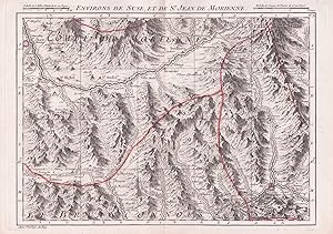
"Environs de Suse et de St. Jean de Morienne" - Susa Modane Saint-Jean-de-Maurienne Piemonte Italia Savoie Savoia Auvergine France Karte map
Sprache: Französisch
Verlag: Paris, Dheulland, 1748
Anbieter: Antiquariat Steffen Völkel GmbH, Seubersdorf, Deutschland
Verkäuferbewertung 5 von 5 Sternen
Karte
Blattmasse: ca. 25,5 x 35,5 cm. - Seltene grenzkolorierte Kupferstich-Karte von 1748. -- gut erhalten. || Rare colored copper engraved map from 1748. in very good condition. // Wir, das Antiquariat Steffen Völkel, kaufen und verkaufen alte Bücher, Handschriften, Zeichnungen, Autographen, Grafiken und Fotografien. Wir sind stets am Ankauf von kompletten Bibliotheken, Sammlungen und Nachlässen interessiert. Sprache: Französisch Gewicht in Gramm: 20.
-

"Environs de Monstier et de Morges" - Morgex Bourg-Saint-Maurice Moutiers Aostatal Savoie Savoia Italy Italia Italien France Frankreich Karte map
Sprache: Französisch
Verlag: Paris, Dheulland, 1748
Anbieter: Antiquariat Steffen Völkel GmbH, Seubersdorf, Deutschland
Verkäuferbewertung 5 von 5 Sternen
Karte
Blattmasse: ca. 25,5 x 35,5 cm. - Seltene grenzkolorierte Kupferstich-Karte von 1748. -- gut erhalten. || Rare colored copper engraved map from 1748. in very good condition. // Wir, das Antiquariat Steffen Völkel, kaufen und verkaufen alte Bücher, Handschriften, Zeichnungen, Autographen, Grafiken und Fotografien. Wir sind stets am Ankauf von kompletten Bibliotheken, Sammlungen und Nachlässen interessiert. Sprache: Französisch Gewicht in Gramm: 20.
-

"Environs de Genes, Savone et Finale" - Genova Savona Finale Ligure Liguria Italia Itlay Italien Karte map
Sprache: Französisch
Verlag: Paris, Dheulland, 1748
Anbieter: Antiquariat Steffen Völkel GmbH, Seubersdorf, Deutschland
Verkäuferbewertung 5 von 5 Sternen
Karte
Blattmasse: ca. 25,5 x 35,5 cm. - Seltene grenzkolorierte Kupferstich-Karte von 1748. -- gut erhalten. || Rare colored copper engraved map from 1748. in very good condition. // Wir, das Antiquariat Steffen Völkel, kaufen und verkaufen alte Bücher, Handschriften, Zeichnungen, Autographen, Grafiken und Fotografien. Wir sind stets am Ankauf von kompletten Bibliotheken, Sammlungen und Nachlässen interessiert. Sprache: Französisch Gewicht in Gramm: 20.
-
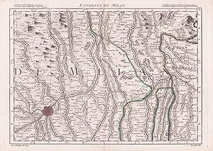
"Environs de Milan" - Milano Soncino Treviglio Lombardia Italy Italia Italien Karte map
Sprache: Französisch
Verlag: Paris, Dheulland, 1748
Anbieter: Antiquariat Steffen Völkel GmbH, Seubersdorf, Deutschland
Verkäuferbewertung 5 von 5 Sternen
Karte
Blattmasse: ca. 25,5 x 35,5 cm. - Seltene grenzkolorierte Kupferstich-Karte von 1748. -- gut erhalten. || Rare colored copper engraved map from 1748. in very good condition. // Wir, das Antiquariat Steffen Völkel, kaufen und verkaufen alte Bücher, Handschriften, Zeichnungen, Autographen, Grafiken und Fotografien. Wir sind stets am Ankauf von kompletten Bibliotheken, Sammlungen und Nachlässen interessiert. Sprache: Französisch Gewicht in Gramm: 20.
-
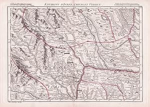
"Environs d'Ivree, Chivas et Verrue" - Ivrea Santhia Chivasso Crescentino Piemonte Italia Italy Italien Karte map
Sprache: Französisch
Verlag: Paris, Dheulland, 1748
Anbieter: Antiquariat Steffen Völkel GmbH, Seubersdorf, Deutschland
Verkäuferbewertung 5 von 5 Sternen
Karte
Blattmasse: ca. 25,5 x 35,5 cm. - Seltene grenzkolorierte Kupferstich-Karte von 1748. -- gut erhalten. || Rare colored copper engraved map from 1748. in very good condition. // Wir, das Antiquariat Steffen Völkel, kaufen und verkaufen alte Bücher, Handschriften, Zeichnungen, Autographen, Grafiken und Fotografien. Wir sind stets am Ankauf von kompletten Bibliotheken, Sammlungen und Nachlässen interessiert. Sprache: Französisch Gewicht in Gramm: 20.
-

Plan des Attaques de la Ville de Lille. Planche n°47.
Verlag: ***
Karte
Pas de couverture. Zustand: bon. RO80092365: XIXe sičcle. In-4. En feuillets. Bon état, Couv. convenable, Dos satisfaisant, Intérieur frais. Un plan gravé en noir et blanc, de 24.5 x 39 cm. A l'italienne. . . . Classification Dewey : 912-Atlas, cartes et plans.
-

Plan du Bassin de Quebec et de Ses Environs
Erscheinungsdatum: 1744
Anbieter: Attic Books (ABAC, ILAB), London, ON, Kanada
Verkäuferbewertung 5 von 5 Sternen
Zustand: Near fine. Approx. 22x31 cm copperplate engraving in 35x43 cm grey mat. On backerboard, wrapped in mylar. Hand coloured. N. B. is Jacques-Nicolas Bellin (1703-72), French hydrographer and geographer.
-

Plan de la Ville de Meaco
Verlag: Chez Didot, 1752]., [Paris,, 1752
Anbieter: Daniel Crouch Rare Books Ltd, London, Vereinigtes Königreich
Verbandsmitglied: ABA ILAB PBFA
Verkäuferbewertung 4 von 5 Sternen

Karte
EUR 178,66
EUR 23,13 Versand
Versand von Vereinigtes Königreich nach USAAnzahl: 1 verfügbar
In den WarenkorbPlan of Kyoto Engraved plan. A plan of Kyoto (Meaco) from a later edition of the Abbé Prévost's travel book, the 'Histoire Generale des Voyages'. Prévost's work was an expansion of Thomas Astley's 'Voyages and Travels' compiled by Astley from sources including John Atkins, Theodor de Bry and Jean-Baptiste Lavat. The first seven volumes of Astley's work were translated into French by the Abbé Antoine François Prévost (1697-1763). As well as translating Astley's work, Prévost added a general history of discoveries and colonisation to his own lifetime, as well as an overview of the historical sources he used. The maps and plans in Prévost's work were drawn by Jacques Nicolas Bellin, and engraved by Guillaume Dheulland.
-

Plan de la Ville de Meaco
Verlag: Chez Didot, 1752]., [Paris,, 1752
Anbieter: Daniel Crouch Rare Books Ltd, London, Vereinigtes Königreich
Verbandsmitglied: ABA ILAB PBFA
Verkäuferbewertung 4 von 5 Sternen
Karte
EUR 178,66
EUR 23,13 Versand
Versand von Vereinigtes Königreich nach USAAnzahl: 1 verfügbar
In den WarenkorbPlan of Kyoto Engraved plan. A plan of Kyoto (Meaco) from a later edition of the Abbé Prévost's travel book, the 'Histoire Generale des Voyages'. Prévost's work was an expansion of Thomas Astley's 'Voyages and Travels' compiled by Astley from sources including John Atkins, Theodor de Bry and Jean-Baptiste Lavat. The first seven volumes of Astley's work were translated into French by the Abbé Antoine François Prévost (1697-1763). As well as translating Astley's work, Prévost added a general history of discoveries and colonisation to his own lifetime, as well as an overview of the historical sources he used. The maps and plans in Prévost's work were drawn by Jacques Nicolas Bellin, and engraved by Guillaume Dheulland.
-
ENVIRONS DE SESTO, ET DE BIAGRASSO
Verlag: Cartografia, Lombardia - Piemonte
Anbieter: Sergio Trippini, Gavirate, VA, Italien
Verkäuferbewertung 4 von 5 Sternen
Raffigurazione del territorio tra Borgo Sesia e Abbiategrasso, contenuta nell'atlante "Theatre de la guerre en Italie ou Carte nouvelle des Principauté de Piemont, République de Genes, Duchés de Milan, Plaisance, et Confins. Dedite et presente au Roy per ses trčs humbles obéissants et fidels sujets G. Dheulland et R. Julien". A Paris chez Dheulland, 1748.
-
![Bild des Verkäufers für Plan de la Ville de Meaco [Kyoto / Kioto] zum Verkauf von Frame](https://pictures.abebooks.com/inventory/md/md30644565490.jpg)
Zustand: ACEPTABLE. Mapa de Kioto estampadopara la Historia de Japón del Padre Charlevoix, de la compańía de Jesús, en 1736.Basado en la cartografía de Jacques Nicolas Bellin (1703-1772). Formato (cm): 21x30.
-

Plan de la Ville d' Ozaca et de son Chateau / Plano de la Villa de Osaka y de su Castillo
Verlag: Paris, 1736
Kunst / Grafik / Poster
Zustand: ACEPTABLE. Mapa de la ciudad de Osaka en Japón estampado para la Historia de Japón del Padre Charlevoix, de la compańía de Jesús, en 1736. Basado en la cartografía de Jacques Nicolas Bellin (1703-1772). [T.1.4şP.483.et in.12.T.3.P.458] . [Dheulland Sculp.] Formato (cm): 20,5x29.
-
![Bild des Verkäufers für Carte de la Corée [Mapa de Corea] zum Verkauf von Frame](https://pictures.abebooks.com/inventory/md/md30644563628.jpg)
Zustand: ACEPTABLE. Mapa de Corea estampadopara la Historia de Japón del Padre Charlevoix, de la compańía de Jesús, en 1736.Basado en la cartografía de Jacques Nicolas Bellin (1703-1772). [T.1.4.şP.569. et in. 12.T.4.P.153] [Dheulan Sculp] Korea Formato (cm): 29x16,5.
-
![Bild des Verkäufers für Plan du Port et de la Ville de Nangasaki [Nagasaki] zum Verkauf von Frame](https://pictures.abebooks.com/inventory/md/md30644566454.jpg)
Zustand: ACEPTABLE. Mapa de Nagasaki estampadopara la Historia de Japón del Padre Charlevoix, de la compańía de Jesús, en 1736.Basado en la cartografía de Jacques Nicolas Bellin (1703-1772). [T.2.4ş.P.546.et in 12.T.S.P.1re] [Dheulland Sculp.] Japón - Japan - Nagasaki Formato (cm): 21x46.
-
![Bild des Verkäufers für Plan de Jedo [Tokio] zum Verkauf von Frame](https://pictures.abebooks.com/inventory/md/md30644561803.jpg)
Zustand: ACEPTABLE. Edo («estuario»), a veces romanizado como Jedo, Yedo o Yeddo, es el nombre que tuvo Tokio hasta 1868, ańo de la restauración Meiji. Mapa de Tokio estampadopara la Historia de Japón del Padre Charlevoix, de la compańía de Jesús, en 1736.Basado en la cartografía de Jacques Nicolas Bellin (1703-1772). Formato (cm): 36x34.
-
![Bild des Verkäufers für Caste des Isles du Japon et des Costes de la Chine . Pays de Kamtschatka [Península de Kamchatka] . Terre de Jesso zum Verkauf von Frame](https://pictures.abebooks.com/inventory/md/md30644566453.jpg)
Caste des Isles du Japon et des Costes de la Chine . Pays de Kamtschatka [Península de Kamchatka] . Terre de Jesso
Verlag: Paris, 1735
Kunst / Grafik / Poster
Zustand: ACEPTABLE. Mapa de Japón, la costa China, la península de Kamchatka y el mar de Jesso,estampadopara la Historia de Japón del Padre Charlevoix, de la compańía de Jesús, en 1736.Basado en la cartografía de Jacques Nicolas Bellin (1703-1772). Formato (cm): 35x28.
-
Carte nouvelle du duché de Brabant et partie de la Hollande dressée sur les meilleures cartes levées dans les Pays. Paris, chez l'auteur, s.d. [1747].
Anbieter: Librairie L'Abac / Gimmic SRL, Bruxelles, Belgien
Verbandsmitglied: ILAB
Verkäuferbewertung 5 von 5 Sternen
Un volume In-8 étroit, plein veau, dos lisse, titre doré (Reliure de l'époque). Atlas militaire comprenant une carte d'assemblage et 24 cartes particuličres aux liserés coloriés. Les cartes, de format in-4, ont été repliées dans une reliure étroite ayant « la forme d'un livre portatif, pour l'usage de Mrs les Officiers des Trouppes de sa Majesté ». Trčs pâles mouillures éparses, quelques trčs légčres coupures et le long des plis. Petite déchirure sur la carte d'assemblage et rousseurs sur un pli. Agréable exemplaire néanmoins. Livres.
-
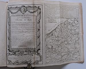
THEATRE DE LA GUERRE DANS LES PAYS BAS DEDIE AU ROY.
Erscheinungsdatum: 1756
Anbieter: Charles Russell, ABA, ILAB, est 1978, Cirencester, Vereinigtes Königreich
Verbandsmitglied: ABA ILAB PBFA
Verkäuferbewertung 5 von 5 Sternen
EUR 2.084,33
EUR 4,74 Versand
Versand von Vereinigtes Königreich nach USAAnzahl: 1 verfügbar
In den WarenkorbTall octavo 10x5 inches, HANDSOMELY LEATHER BOUND IN FULL PERIOD CALF, gilt floral tooling and period endpapers, small blemish to the bottom back corner but the binding in good condition. Engraved rococo title and general map on one sheet, and 14 folding engraved maps numbered 2-15. 2nd engraved title and general map on one sheet- Carte Nouvelle du Duche de Brabant et Provinces Voisines, and 24 folding maps numbered 17 to 40. THUS A TOTAL TO TWO TITLES AND 40 MAPS. Map number 40 is a bit wrinkled and laid down otherwise a very good copy in a lovely period binding. ATLAS HOLLAND AND BELGIUM.
-

Théâtre de la guerre en Italie ou Carte nouvelle des principautés de Piémont, république de Gęnes, duché de Milan, Plaisance et Confins.
Anbieter: LAM (Livres Anciens Et Modernes), MONTPELLIER, Frankreich
Verbandsmitglied: ILAB
Verkäuferbewertung 1 von 5 Sternen

P., Chez l?auteur et chez Grosseau, 1748. Titre, carte générale et 23 cartes régionales coloriées au trait (feuillet 6 défraîchi avec manque angulaire, quelques salissures par ailleurs), en feuilles telles que parues. Manquent les deux feuillets de table. Carte trčs détaillée qui couvre également une partie de la Suisse.
-
Carte Reduite de la Mer Mediterranee pour Servir aux Vaisseaux du Roy Dressee au Depost des Cartes et Plans de la Marine Par ordre de Mgr. Le Comte de Maurepas
Erscheinungsdatum: 1737
Anbieter: Antipodean Books, Maps & Prints, ABAA, Garrison, NY, USA
Verbandsmitglied: ABAA ANZAAB ESA ILAB
Verkäuferbewertung 3 von 5 Sternen

Uncolored engraved map of the western half of the Mediterranean, from the Strait of Gibraltar in the west to the island of Sardinia in the east, and showing the islands 'Ile D'Yvice', 'I. Mayorque', 'Isle de Sardaigne', and 'I. de Corse', with Barbarie to the south, and Espagne and France in the north. The first section of a three part map of the entire Mediterranean. With rhumb lines and compass rose; 'Avertissement' text block at the lower right corner. 'No. 38 I Feuille' at the upper right above the border. Image size: 21 1/2 x 25". Paper size: 25 1/2 x 37 1/4". Two short closed tears at right edge; small torn area at top right corner, faint offsetting at lower left, below first two letters of 'Barbarie', otherwise very good.

![Bild des Verkäufers für Carte nouvelle du duché de Brabant et partie de la Hollande dressée sur les meilleures cartes levées dans les Pays. Paris, chez l'auteur, s.d. [1747]. zum Verkauf von Librairie L'Abac / Gimmic SRL](https://pictures.abebooks.com/inventory/md/md31168798106.jpg)