Gesamtpreis (1 Artikel Artikel):
Versandziel:

denoyer geppert (3 Ergebnisse)
Direkt zu den wichtigsten Suchergebnissen
Suchfilter
Produktart
- Alle Product Types
- Bücher (1)
- Magazine & Zeitschriften (Keine weiteren Ergebnisse entsprechen dieser Verfeinerung)
- Comics (Keine weiteren Ergebnisse entsprechen dieser Verfeinerung)
- Noten (Keine weiteren Ergebnisse entsprechen dieser Verfeinerung)
- Kunst, Grafik & Poster (Keine weiteren Ergebnisse entsprechen dieser Verfeinerung)
- Fotografien (Keine weiteren Ergebnisse entsprechen dieser Verfeinerung)
- Karten (2)
- Manuskripte & Papierantiquitäten (Keine weiteren Ergebnisse entsprechen dieser Verfeinerung)
Zustand Mehr dazu
- Neu (Keine weiteren Ergebnisse entsprechen dieser Verfeinerung)
- Wie Neu, Sehr Gut oder Gut Bis Sehr Gut (Keine weiteren Ergebnisse entsprechen dieser Verfeinerung)
- Gut oder Befriedigend (Keine weiteren Ergebnisse entsprechen dieser Verfeinerung)
- Ausreichend oder Schlecht (Keine weiteren Ergebnisse entsprechen dieser Verfeinerung)
- Wie beschrieben (3)
Einband
- alle Einbände
- Hardcover (Keine weiteren Ergebnisse entsprechen dieser Verfeinerung)
- Softcover (Keine weiteren Ergebnisse entsprechen dieser Verfeinerung)
Weitere Eigenschaften
- Erstausgabe (Keine weiteren Ergebnisse entsprechen dieser Verfeinerung)
- Signiert (Keine weiteren Ergebnisse entsprechen dieser Verfeinerung)
- Schutzumschlag (Keine weiteren Ergebnisse entsprechen dieser Verfeinerung)
- Angebotsfoto (3)
Sprache (1)
Preis
- Beliebiger Preis
- Weniger als EUR 20 (Keine weiteren Ergebnisse entsprechen dieser Verfeinerung)
- EUR 20 bis EUR 45 (Keine weiteren Ergebnisse entsprechen dieser Verfeinerung)
- Mehr als EUR 45
Gratisversand
- Kostenloser Versand nach USA (Keine weiteren Ergebnisse entsprechen dieser Verfeinerung)
Land des Verkäufers
Verkäuferbewertung
-
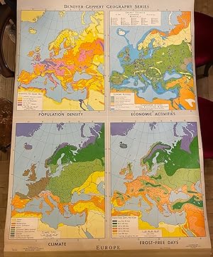
Europe
Verlag: Denoyer Geppert, Chicago, 1968
Anbieter: Argosy Book Store, ABAA, ILAB, New York, NY, USA
Verkäuferbewertung 5 von 5 Sternen

Roller map. Includes original hanging bracket. Measures 56 1/2" x 43 1/2" Colorful school map featuring four maps of Europe depicting population density, economic activities, climate types, and frost-free days. In very good condition, with some wear to bottom left and minor scuffing. Denoyer-Geppert was formed in Chicago in the early 20th century as a purveyor of maps and globes. In the post-war period, they concentrated their production on educational tools. They gained acclaim and popularity in the 1960s when their Cartograph Globe appeared alongside Apollo astronauts in publicity photographs for NASA's burgeoning space program. Over the next decades, Denoyer-Geppert developed a robust selection of innovative scientific products used in fields as disparate as anatomy and chemistry. This map is a fascinating example of their work.
-

Secession 1860-1861.
Erscheinungsdatum: 1940
Anbieter: Geographicus Rare Antique Maps, Brooklyn, NY, USA
Verbandsmitglied: ABAA ESA ILAB
Verkäuferbewertung 4 von 5 Sternen

Karte
Very good. Backed on linen. Attached to original rollers. Measurment is for the map itself. Since the map is attached to rods, they add an another 2 inches in height and 3.5 inches in width. Size 30.5 x 43.5 Inches. This is a c. 1940s Albert Bushnell Hart and Denoyer-Geppert Company wall map of the United States. The map depicts the continental United States from the Pacific Ocean to the Atlantic Ocean and from Canada (labeled British Possessions) to Mexico. The states are shaded multiple different colors to differentiate between the states and territories that remained in the Union and those that seceded. The two different colors employed to denote the states that seceded are divided in two: those that seceded before April 14, 1861 and those that seceded after. Fort Sumter, a U.S. Army fort in Charleston Harbor, surrendered April 14, 1861, and President Lincoln issued a proclamation calling up 75,000 troops to put down the rebellion. For four states, Arkansas, Tennessee, North Carolina, and Virginia, this was the act that pushed them into joining the Confederacy. Missouri, Kentucky, Maryland, and Delaware which are shaded green, were slave states that never declared secession. West Virginia, joined the Union in 1863, when it seceded from Virginia. Several notations on the map refer to the state of war between the Confederate States of America and the United States of America. Forts are depicted and are labeled by which side held which fort. A handful of arsenals and navy yards are also included. An inset map of Charleston Harbor is located along the bottom border next to the key. Regarding the general geography of the map, the state capitals and other major cities are labeled, along with rivers and the Great Lakes. This map was created by Albert Bushnell Hart with L. Philip Denoyer serving as geographer. The map was compiled and drawn by R. Baxter Blair and published by the Denoyer-Geppert Company of Chicago. It is number A15 in the Denoyer-Geppert Social Science map series. We have dated this map as c. 1940s due to the paper it is printed on. Several different editions of this map were printed, which allows for the possibility that this particular example could date from an earlier or later year.
-

Characteristic Actions of ALCOHOL.
Erscheinungsdatum: 1935
Anbieter: Geographicus Rare Antique Maps, Brooklyn, NY, USA
Verbandsmitglied: ABAA ESA ILAB
Verkäuferbewertung 4 von 5 Sternen
Karte
Good. Mounted on original linen. Some soiling and foxing. Size 30.25 x 43 Inches. This is an iconic 1935 Denoyer-Geppert persuasive anti-alcoholism poster highlighting the product's negative effects on the human body. Issued in the wake of Prohibition's 1933 repeal, this piece pointedly asks, why ingest beer, wine, and liquor when the same key chemicals are used in paint, shellac, varnish, perfume, and explosives? Due to its powerful imagery, this piece has been widely reproduced, but this is our first time encountering an original. A Closer Look An illustration of a man occupies the center: his left side wears a suit, but his right exposes internal organs, the circulatory system, and the skeleton. To the left, products made using alcohol appear on shelves, including varnish, paint, shellac, hair tonic, perfume, explosives, and photographic film. On the right, beer, wine, and whiskey appear above a list of alcohol's poisonous, narcotic, and addictive effects on 'living tissue'. Publication History and Census This poster was edited by Bertha Rachel Palmer (the former Superintendent of Public Instruction of North Dakota) and published by Denoyer-Geppert in 1935. While widely reproduced in a reduced format, originals are rare. This piece is not cataloged in OCLC, and we have not identified any institutional holdings.