Gesamtpreis (1 Artikel Artikel):
Versandziel:

delamarche charles (48 Ergebnisse)
Direkt zu den wichtigsten Suchergebnissen
Suchfilter
Produktart
- Alle Product Types
- Bücher (30)
- Magazine & Zeitschriften (Keine weiteren Ergebnisse entsprechen dieser Verfeinerung)
- Comics (Keine weiteren Ergebnisse entsprechen dieser Verfeinerung)
- Noten (Keine weiteren Ergebnisse entsprechen dieser Verfeinerung)
- Kunst, Grafik & Poster (1)
- Fotografien (Keine weiteren Ergebnisse entsprechen dieser Verfeinerung)
- Karten (17)
- Manuskripte & Papierantiquitäten (Keine weiteren Ergebnisse entsprechen dieser Verfeinerung)
Zustand Mehr dazu
Einband
Weitere Eigenschaften
- Erstausgabe (1)
- Signiert (Keine weiteren Ergebnisse entsprechen dieser Verfeinerung)
- Schutzumschlag (Keine weiteren Ergebnisse entsprechen dieser Verfeinerung)
- Angebotsfoto (38)
Sprache (4)
Gratisversand
Land des Verkäufers
Verkäuferbewertung
-

Les Usages de la Sph?re, Et des Globes C?leste Et Terrestre, Pr?c?d?s d''un Abr?g? sur les Diff?rens Syst?mes du Monde: Suivis de la Description Et des Usages de la G?o-Cyclique, du D?nombrement des Constellations Anciennes Et Modernes, Et de la
Anbieter: PBShop.store US, Wood Dale, IL, USA
Verkäuferbewertung 5 von 5 Sternen

PAP. Zustand: New. New Book. Shipped from UK. Established seller since 2000.
-
Les Usages de la Sph?re, Et des Globes C?leste Et Terrestre, Pr?c?d?s d''un Abr?g? sur les Diff?rens Syst?mes du Monde: Suivis de la Description Et des Usages de la G?o-Cyclique, du D?nombrement des Constellations Anciennes Et Modernes, Et de la
Anbieter: PBShop.store UK, Fairford, GLOS, Vereinigtes Königreich
Verkäuferbewertung 4 von 5 Sternen

EUR 24,42
EUR 4,80 Versand
Versand von Vereinigtes Königreich nach USAAnzahl: 15 verfügbar
In den WarenkorbPAP. Zustand: New. New Book. Shipped from UK. Established seller since 2000.
-

Atlas Élémentaire, Composé de XXXIII Cartes. 4e Éd (Éd.1816) (Histoire) (French Edition)
Anbieter: Ria Christie Collections, Uxbridge, Vereinigtes Königreich
Verkäuferbewertung 5 von 5 Sternen
EUR 18,41
EUR 13,83 Versand
Versand von Vereinigtes Königreich nach USAAnzahl: Mehr als 20 verfügbar
In den WarenkorbZustand: New. In.
-

Les Usages de la Sph?re, Et des Globes C?leste Et Terrestre, Pr?c?d?s d'un Abr?g? sur les Diff?rens Syst?mes du Monde: Suivis de la Description Et des . Anciennes Et Modernes, Et de la
Anbieter: PBShop.store US, Wood Dale, IL, USA
Verkäuferbewertung 5 von 5 Sternen
HRD. Zustand: New. New Book. Shipped from UK. Established seller since 2000.
-
Les Usages de la Sph?re, Et des Globes C?leste Et Terrestre, Pr?c?d?s d'un Abr?g? sur les Diff?rens Syst?mes du Monde: Suivis de la Description Et des . Anciennes Et Modernes, Et de la
Anbieter: PBShop.store UK, Fairford, GLOS, Vereinigtes Königreich
Verkäuferbewertung 4 von 5 Sternen
EUR 30,25
EUR 5,80 Versand
Versand von Vereinigtes Königreich nach USAAnzahl: 15 verfügbar
In den WarenkorbHRD. Zustand: New. New Book. Shipped from UK. Established seller since 2000.
-

Les Usages de la Sphčre, Des Globes Céleste Et Terrestre. 8e Édition (French Edition)
Anbieter: Ria Christie Collections, Uxbridge, Vereinigtes Königreich
Verkäuferbewertung 5 von 5 Sternen
EUR 23,74
EUR 13,83 Versand
Versand von Vereinigtes Königreich nach USAAnzahl: Mehr als 20 verfügbar
In den WarenkorbZustand: New. In.
-

Description Géographique Et Historique Des Peuples Les Plus Renommés de l'Europe (Éd.1809) (Histoire) (French Edition)
Anbieter: Ria Christie Collections, Uxbridge, Vereinigtes Königreich
Verkäuferbewertung 5 von 5 Sternen
EUR 26,33
EUR 13,83 Versand
Versand von Vereinigtes Königreich nach USAAnzahl: Mehr als 20 verfügbar
In den WarenkorbZustand: New. In.
-

EUR 23,27
EUR 48,99 Versand
Versand von Deutschland nach USAAnzahl: Mehr als 20 verfügbar
In den WarenkorbZustand: New.
-

EUR 29,02
EUR 48,99 Versand
Versand von Deutschland nach USAAnzahl: Mehr als 20 verfügbar
In den WarenkorbZustand: New.
-

EUR 31,82
EUR 48,99 Versand
Versand von Deutschland nach USAAnzahl: Mehr als 20 verfügbar
In den WarenkorbZustand: New.
-

EUR 38,60
EUR 48,99 Versand
Versand von Deutschland nach USAAnzahl: Mehr als 20 verfügbar
In den WarenkorbGebunden. Zustand: New.
-

Les Usages De La Sphere Et Des Globes
Sprache: Französisch
Verlag: Kessinger Publishing, LLC, 2009
ISBN 10: 1120313600 ISBN 13: 9781120313607
EUR 40,13
EUR 48,99 Versand
Versand von Deutschland nach USAAnzahl: Mehr als 20 verfügbar
In den WarenkorbZustand: New.
-

Description Géographique Et Historique Des Peuples Les Plus Renommés de l'Europe (Éd.1809)
Sprache: Französisch
Verlag: Hachette Livre - BNF Jun 2012, 2012
ISBN 10: 2012648932 ISBN 13: 9782012648937
Anbieter: AHA-BUCH GmbH, Einbeck, Deutschland
Verkäuferbewertung 5 von 5 Sternen
Taschenbuch. Zustand: Neu. Neuware - Description geographique et historique des peuples les plus renommes de l'Europe ancienne et des lieux les plus remarquables. , Un atlas compose de 18 cartes vient a l'appui. Par C.-F. Delamarche,.Date de l'edition originale : 1809Ce livre est la reproduction fidele d'une oeuvre publiee avant 1920 et fait partie d'une collection de livres reimprimes a la demande editee par Hachette Livre, dans le cadre d'un partenariat avec la Bibliotheque nationale de France, offrant l'opportunite d'acceder a des ouvrages anciens et souvent rares issus des fonds patrimoniaux de la BnF.Les oeuvres faisant partie de cette collection ont ete numerisees par la BnF et sont presentes sur Gallica, sa bibliotheque numerique.En entreprenant de redonner vie a ces ouvrages au travers d'une collection de livres reimprimes a la demande, nous leur donnons la possibilite de rencontrer un public elargi et participons a la transmission de connaissances et de savoirs parfois difficilement accessibles.Nous avons cherche a concilier la reproduction fidele d'un livre ancien a partir de sa version numerisee avec le souci d'un confort de lecture optimal. Nous esperons que les ouvrages de cette nouvelle collection vous apporteront entiere satisfaction.Pour plus d'informations, rendez-vous sur hachettebnf.frgallica.bnf.fr/ark:/12148/bpt6k432433g.
-

Les Usages De La Sphčre Et Des Globes Céleste Et Terrestre, Précédés D'un Abiégé Sur Les Différens Systčmes Du Monde : Suivis De La Description Et Des Usages De La Géo-Cyclique .
Sprache: Französisch
Verlag: Creative Media Partners, LLC Jul 2018, 2018
ISBN 10: 0270904204 ISBN 13: 9780270904208
Anbieter: AHA-BUCH GmbH, Einbeck, Deutschland
Verkäuferbewertung 5 von 5 Sternen
Buch. Zustand: Neu. Neuware - This work has been selected by scholars as being culturally important, and is part of the knowledge base of civilization as we know it. This work was reproduced from the original artifact, and remains as true to the original work as possible. Therefore, you will see the original copyright references, library stamps (as most of these works have been housed in our most important libraries around the world), and other notations in the work.
-
Zustand: Hervorragend. Zustand: Hervorragend | Sprache: Französisch | Produktart: Bücher | Keine Beschreibung verfügbar.
-
Les Usages del Sphere, et des Globes Céleste et Terrestre, selon le Hypothése de Ptolémée & de Copernic, accompagnées de Figures analogues .Deuxieme Edition par Delamarche, Géographe & Successeur de Robert de Vaugondy. A Paris, Rue du Foin S. Jacques, au Collége de Me Gervais. AN VII (1798)
Sprache: Französisch
Verlag: A Paris, Rue du Foin S. Jacques, au Collége de Me Gervais. AN VII (1798 - AN VII nach Republikanischem Kalender), 1798
Anbieter: Antiquariat Liber Antiqua, Krems an der Donau, Österreich
Verkäuferbewertung 5 von 5 Sternen
Softcover/Paperback. 2. Auflage. 584 Seiten, davon S 565 bis 584 Tafeln gebundene Ausgabe mit Billigeinband Blauer Billigeinband (daher Billigausgabe), kleiner unauffälliger Bibliotheksaufkleber beim Aufschlagen, Seiten schlecht beschnitten, Eselsohren, Seiten etwas gebräunt und stockfleckig - sonst sauber, einige Wurmlöcher, zwischen S188/189 und S576/577 Fehlstelle (möchligerweise Fehlblatt, da der Rand schlecht beschnitten ist und bei S576/577 noch niedergeklebt), S211 - 222: Bändchen gerissen, daher lose, einige Blätter im hinteren Bereich faltig, S339 - 350 ebenfalls gelöst (hängt nur mehr am Bändchen), eher mittelmässiger Zustand Charles-François Delamarche (1740 - 1817) war ein französischer Geograph und Kartenmacher. "Carte générale de l'Asie divisée en ses principaux états", ,Delamarche, 1818 Einer der wichtigsten französischen Geographen und Kartenmacher der zweiten Hälfte des 18. Jahrhunderts. Nachfolger von Nicolas Sanson (1600 - 1667), Robert de Vaugondy (1686 - 1766) und Rigobert Bonne (1727 - 1794), deren Atlanten er nachdruckte. Hat auch Geographie unterrichtet. Zu seinen Werken gehört neben Karten und Kugeln auch eine Abhandlung über die Nutzung der Kugel und der Himmels- und Erdkugeln. In der Abhandlung veranschaulicht er sowohl das ptolemäische als auch das kopernikanische System und listet alle alten und modernen Konstellationen auf. Sein Sohn Félix Delamarche (18. Jahrhundert - 1. Hälfte 19. Jahrhundert) setzte seine Arbeit fort. (sourc. Wik.) Sprache: Französisch.
-

Les usages de la sphere, des globes celeste et terrestre, precedes d'un abrege sur les differents systemes du monde; suivis de la description et des usages de la geo-cyclique, etc. (par Charles-Francois Delamarche). Cinquieme edition; par F(eli)x Delamarche. Die EA. bzw. Edition originale erschien 1791 in Paris, verfasst von dem bedeutenden französischen Geographen und Kartographen Charles-Francois Delamarche (1740-1817). Ab der 4. Auflage von 1821 wurde das Werk von seinem Sohn und Nachfolger Felix Delamarche (1780-1835) bearbeitet.
Verlag: F(eli)x Delamarche, Paris, 1826
Anbieter: AixLibris Antiquariat Klaus Schymiczek, Aachen, Deutschland
Verbandsmitglied: BOEV
Verkäuferbewertung 5 von 5 Sternen
8°. VI, 224 S. Roter Halblederband der Zeit mit etwas Rückenvergoldung. Sprache: Französisch, Mit Abbildungen auf 8 (3 gefalteten) Kupfertafeln und einigen Tabellen im Text. Einband etwas berieben und bestoßen; Bezugspapier der Deckel beschabt (kleine Bezugspapierfehlstellen - insbesondere an den Stehkanten); Vorsätze etwas leimschattig und leicht gebräunt; hinterer Vorsatz leicht tintenfleckig; stockfleckig; Blattränder teils etwas gebräunt; winziger Wappenstempel auf dem Vordervorsatz.
-
Les Usages de la Sphčre et des Globes Céleste et Terrestre
Verlag: Collčge de Me Gervais, Paris, 1799
Anbieter: Eric Zink Livres anciens, PARIS, Frankreich
Verbandsmitglied: ILAB
Verkäuferbewertung 5 von 5 Sternen
Couverture rigide. Zustand: Trčs bon. Plein basane de l'époque, dos lisse. Un volume in-8 (197x124 mm), viii-584 pages et 8 planches (dont la carte de France). Reliure endommagée. Seconde édition. Précis de géographie selon Ptolémée et Copernic. Contient un manuel d'utilisation des sphčres armillaires. ___________________________________________________________________________________ ______________________________ENGLISH_DESCRIPTION : Contemporary full sheep, flat spine. 8vo (197x124 mm), viii-584 pages and 8 plates. Binding worn. Second edition. Summary of geography according to Ptolemy and Copernicus. Contains a user manual for armillary spheres. 670g.
-
Atlas de géographie ancienne et moderne ŕ l'usage de l'école de Saint-Cyr, des collčges et des maisons d'éducation. First edition.
Verlag: Paris: Chez Delamarche et Dien, circa 1820 ., 1820
Anbieter: Wittenborn Art Books, San Francisco, CA, USA
Verkäuferbewertung 5 von 5 Sternen
Zustand: Good. Folio .23 x 32.5 cm. Later half goatskin with marbled boards.33 maps, some fold-outs.OCLC Number / Unique Identifier:18120993:I atlas (33 unnumbered plates, chiefly double page) : illustrations, hand color maps (some folded) ; 34 cm.Expertise by Philippe Henry.
-
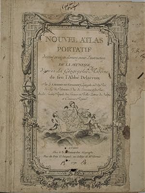
Nouvel atlas portatif destiné principalement pour l instruction de la jeunesse, d aprčs la géographie moderne de feu l abbé Delacroix par le S. Robert de Vaugondy Géographe ord du Roi, de S.M. Polonoise Duc de Lorraine et de Bar, et de la Société Royale des Sciences et Belles Lettres de Nancy, et Censeur Royal.
Verlag: Delamarche, 1790
Anbieter: Librairie Voyage et Exploration, Cerny, Frankreich
Verkäuferbewertung 3 von 5 Sternen

Couverture rigide. Zustand: Moyen. Paris: Chez de S. Delamarche, Géographe, Rue du Foin St. Jacques, au Collčge de Mtre. Gervais, 1790. in-4 (230x280) ,relié demi-daim époque , manque sur un coté [1-2, titre gravé] 3-6 [introduction gravée], [4, tableaux et listes gravés], 52 cartes doubles, gravées sur cuivre avec cartouches ornées, couleur du contour d'origine, gravées par E. Dussy, en fin d ouvrage une grande carte dépliante de la Grčce par Barbié du bocage.rare atlas mis ŕ jour par François Delamarche qui avait repris le fond de Robert de Vaugondy. Commentaires au crayon d époque sur le dos de quelques cartes , quelques mouillures et taches, réparation au titre et ŕ une carte. Mappe-Monde par le S. Robert de Vaugondy1786. Monde en deux hémisphčres. Montrant l'itinéraire de Cook. Mappe-Monde ou Carte Générale de toutes les Parties connue de la Surface du Globe. Apparition précoce des États-Unis d'Amérique et révisée pour montrer les découvertes de Cook.L'Amérique par le S. Robert de Vaugondy. Cartouche orné comprenant une coiffe amérindienne, des flčches et du maďs. Canada, Louisiane, États-Unis. Par Le S. Robert De Vaugondy. Cartouche. Grand encart de la Californie, du Nouveau-Mexique et du Canada. Nouvelle Espagne Nouveau Méxique, Isles Antilles Par le S. Robert de Vaugondy. Encart des Açores, cartouche orné. Les possessions espagnoles sont au centre de cette carte, qui comprend les rivičres du Texas et les noms de lieux pour la baie de Galveston (B. de S. Bernard), R. Colorado de los Martyres, Casa Grande, Nouvelle Navarre (appliqué au Mexique- Arizona Borderlands), Santa Fe, Albuquerque, etc. Les Ceni, les Apaches et d'autres tribus sont localisés, ainsi que quelques missions et presidios. Cette carte donne une perspective différente de la relation qui existe entre les pays et les îles entourant le golfe du Mexique. En délimitant uniquement les régions de la côte du golfe de l'Amérique du Nord, centrale et du Sud, la carte met en évidence les routes commerciales et les liens culturels reliant la région circum-caribéenne. La Louisiane, par exemple, apparaît comme partie intégrante de cette région plutôt que l'Amérique du Nord. P1-5B.
-
Antique Map-EUROPE-POLAND-PRUSIA-AUSTRIA-RUSSIA-Delamarche-ca 1793
Verlag: ca 1793, 1793
Anbieter: Pictura Prints, Art & Books, Overasselt, Niederlande
Verkäuferbewertung 5 von 5 Sternen
Charles-François Delamarche (illustrator). '"LA POLOGNE AVEC SES DÉMEMBREMENTS,". 'This print shows a view on a map of Poland with its borders to Prusia, Austria and Russia.Made by an anonymous engraver after Charles-François Delamarche.Medium: engraving on handlaid (verge) paper.Sheet size: 28 x 21.5 cm (11.02 x 8.46 inch). Image size: 22.3 x 19 cm. (8.78 x 7.48 inch).MAP-EUROPE-POLAND-PRUSIA-AUSTRIA-RUSSIA | RBOS-A10-38BACKGROUND INFORMATIONThis attractive print was published from "Petit atlas moderne .," with editions in 1790 and 1793.Biography artist: Charles François Delamarche (August 1740-31 October 1817) was a French geographer and mapmaker.One of the most important French geographers and mapmakers of the second half of the eighteenth century. Condition: good, given age. Smudges. Bownish edges. Fold as published. Folds in lower corners. Stain in upper left corner. General age-related toning and/or occasional minor defects from handling. Please study scan carefully.
-
PARTIE ORIENTALE DE LA CARTE DES ANCIENNES MONARCHIES OMNIS ANIMA POTESTATIBUS SUBLIMIORIBUS SUBDITA SIT : NON EST ENIM POTESTAS NISI Ŕ DEO : QUAE AUTEM SUNT, Ŕ DEO ORDINATAE SUNT AUX ROMAINS, CH. XIII. V.I.
Sprache: Englisch
Erscheinungsdatum: 1799
Anbieter: Hornseys, Ripon, Vereinigtes Königreich
Verbandsmitglied: PBFA
Verkäuferbewertung 5 von 5 Sternen
EUR 178,41
EUR 28,87 Versand
Versand von Vereinigtes Königreich nach USAAnzahl: 1 verfügbar
In den WarenkorbNo Binding. Zustand: Very Good Plus. Sheet Size: 75.8cm x 55.8cm. Original central fold line. Original or very early hand-colouring. Age toning and minor foxing to the paper and minor creasing. Small mark to the right margin. Archive repairs to the head and tail of the central fold line to the reverse. In very good indeed condition overall. Location: Map Drawer C: FS: Folder M2000 002577.
-

Hongrie, Turquie Europ?
Verlag: Paris, 1795
Anbieter: Alexandre Antique Prints, Maps & Books, Toronto, ON, Kanada
Verkäuferbewertung 5 von 5 Sternen
Karte
Zustand: Excellent. Size : 252x257 (mm), 9.875x10.125 (Inches), Original Outline Coloring.
-

La Lombardie, Le Duche de Toscane L'Etat du St. Siege, et L'Isle de Corse
Verlag: Paris, 1795
Anbieter: Alexandre Antique Prints, Maps & Books, Toronto, ON, Kanada
Verkäuferbewertung 5 von 5 Sternen
Karte
Zustand: Excellent. Size : 266x310 (mm), 10.5x12.25 (Inches), Original Outline Coloring.
-

Cercles de Baviere et d'Autriche
Verlag: Paris, 1795
Anbieter: Alexandre Antique Prints, Maps & Books, Toronto, ON, Kanada
Verkäuferbewertung 5 von 5 Sternen
Karte
Size : 260x300 (mm), 10.25x11.75 (Inches), Original Outline Coloring Very Good; very few light occasional browning spots; two small wormholes in the upper marin.
-

Barbarie, Egypte, Nigritie, Guinee, Nubie, Abissinie.
Verlag: Paris, 1795
Anbieter: Alexandre Antique Prints, Maps & Books, Toronto, ON, Kanada
Verkäuferbewertung 5 von 5 Sternen
Karte
Zustand: Excellent. Size : 260x380 (mm), 10.25x15 (Inches), Original Outline Coloring.
-

L'Irelande
Verlag: Paris, 1795
Anbieter: Alexandre Antique Prints, Maps & Books, Toronto, ON, Kanada
Verkäuferbewertung 5 von 5 Sternen
Karte
Zustand: Excellent. Size : 260x228 (mm), 10.25x9 (Inches), Hand Colored in Outline.
-

Norwege / Royaume de Danemarck
Verlag: Paris, 1795
Anbieter: Alexandre Antique Prints, Maps & Books, Toronto, ON, Kanada
Verkäuferbewertung 5 von 5 Sternen
Karte
Zustand: Excellent. Size : 255x225 (mm), 10x8.875 (Inches), Original Outline Coloring.
-

Paraguay Chili, Terre Magellan
Verlag: Paris, 1797
Anbieter: Alexandre Antique Prints, Maps & Books, Toronto, ON, Kanada
Verkäuferbewertung 5 von 5 Sternen
Karte
Zustand: Very Good. French map of Paraguay, Chili, and Argentina., Size : 265x215 (mm), 10.375x8.5 (Inches), Original Outline Coloring.
-
Partie Septentrionale de la Russie Europeenne
Verlag: Charles Francois Delamarche c. 1850, Paris, 1850
Anbieter: William Chrisant & Sons, ABAA, ILAB. IOBA, ABA, Ephemera Society, Fort Lauderdale, FL, USA
Verbandsmitglied: ABAA ESA ILAB
Verkäuferbewertung 5 von 5 Sternen
Zustand: Very Good. Paper size: 291 x 432 mm. Plate size: 251 x 312 mm. 18th century map in original hand-coloring. Foxing to cartouche. Please see image. ; All shipments through USPS insured Priority Mail.