
Gesamtpreis (1 Artikel Artikel):
Versandziel:

cowperthwait thomas (34 Ergebnisse)
Direkt zu den wichtigsten Suchergebnissen
Suchfilter
Produktart
- Alle Product Types
- Bücher (31)
- Magazine & Zeitschriften (Keine weiteren Ergebnisse entsprechen dieser Verfeinerung)
- Comics (Keine weiteren Ergebnisse entsprechen dieser Verfeinerung)
- Noten (Keine weiteren Ergebnisse entsprechen dieser Verfeinerung)
- Kunst, Grafik & Poster (Keine weiteren Ergebnisse entsprechen dieser Verfeinerung)
- Fotografien (Keine weiteren Ergebnisse entsprechen dieser Verfeinerung)
- Karten (2)
- Manuskripte & Papierantiquitäten (1)
Zustand Mehr dazu
- Neu (7)
- Wie Neu, Sehr Gut oder Gut Bis Sehr Gut (1)
- Gut oder Befriedigend (6)
- Ausreichend oder Schlecht (Keine weiteren Ergebnisse entsprechen dieser Verfeinerung)
- Wie beschrieben (20)
Einband
Weitere Eigenschaften
- Erstausgabe (Keine weiteren Ergebnisse entsprechen dieser Verfeinerung)
- Signiert (Keine weiteren Ergebnisse entsprechen dieser Verfeinerung)
- Schutzumschlag (Keine weiteren Ergebnisse entsprechen dieser Verfeinerung)
- Angebotsfoto (29)
Sprache (2)
Gratisversand
Land des Verkäufers
Verkäuferbewertung
-

Every Philadelphian's Book, and Strangers' Guide Classic Reprint
Anbieter: PBShop.store US, Wood Dale, IL, USA
Verkäuferbewertung 5 von 5 Sternen

PAP. Zustand: New. New Book. Shipped from UK. Established seller since 2000.
-
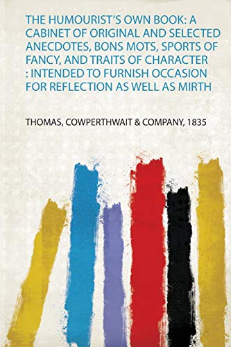
The Humourist's Own Book: a Cabinet of Original and Selected Anecdotes, Bons Mots, Sports of Fancy, and Traits of Character : Intended to Furnish Occasion for Reflection as Well as Mirth
Anbieter: PBShop.store UK, Fairford, GLOS, Vereinigtes Königreich
Verkäuferbewertung 5 von 5 Sternen
EUR 21,19
EUR 5,82 Versand
Versand von Vereinigtes Königreich nach USAAnzahl: 15 verfügbar
In den WarenkorbPAP. Zustand: New. New Book. Shipped from UK. Established seller since 2000.
-
Every Philadelphian's Book, and Strangers' Guide Classic Reprint
Anbieter: PBShop.store UK, Fairford, GLOS, Vereinigtes Königreich
Verkäuferbewertung 5 von 5 Sternen
EUR 24,98
EUR 3,81 Versand
Versand von Vereinigtes Königreich nach USAAnzahl: 15 verfügbar
In den WarenkorbPAP. Zustand: New. New Book. Shipped from UK. Established seller since 2000.
-

Every Philadelphian's Book, and Strangers' Guide Classic Reprint
Anbieter: PBShop.store US, Wood Dale, IL, USA
Verkäuferbewertung 5 von 5 Sternen
HRD. Zustand: New. New Book. Shipped from UK. Established seller since 2000.
-
Every Philadelphian's Book, and Strangers' Guide Classic Reprint
Anbieter: PBShop.store UK, Fairford, GLOS, Vereinigtes Königreich
Verkäuferbewertung 5 von 5 Sternen
EUR 33,33
EUR 4,82 Versand
Versand von Vereinigtes Königreich nach USAAnzahl: 15 verfügbar
In den WarenkorbHRD. Zustand: New. New Book. Shipped from UK. Established seller since 2000.
-

EUR 25,42
EUR 48,99 Versand
Versand von Deutschland nach USAAnzahl: Mehr als 20 verfügbar
In den WarenkorbZustand: New. KlappentextrnrnThis is a reproduction of the original artefact. Generally these books are created from careful scans of the original. This allows us to preserve the book accurately and present it in the way the author intended. Since the origina.
-

Description of Origen and California Embracing an Account of the Gold Regions
Sprache: Englisch
Verlag: Creative Media Partners, LLC Mär 2019, 2019
ISBN 10: 1010307541 ISBN 13: 9781010307549
Anbieter: AHA-BUCH GmbH, Einbeck, Deutschland
Verkäuferbewertung 5 von 5 Sternen
Taschenbuch. Zustand: Neu. Neuware.
-

Persia Arabia &c
Sprache: Englisch
Verlag: Thomas, Cowperthwait, & Co, Philadelphia, 1850
Anbieter: Argosy Book Store, ABAA, ILAB, New York, NY, USA
Verkäuferbewertung 5 von 5 Sternen
unbound. Map. Engraving with original hand coloring. Image measures 12 1/4" x 15". Philadelphia: 1850. Beautifully detailed map of Arabia and surrounding regions comprising present-day Iran, Iraq, and Pakistan. The map delineates capitals, important towns, smaller settlements, rivers, topography and major routes. Mountains are depicted by hachure. In very good condition, with overall toning and minor creasing and closed tears to upper right margins, not affecting the image. One small spot near 30 degrees north, 46 degrees east. Thomas, Cowperthwait & Co. took over publication of S. A. Mitchell's important "Universal Atlas" in 1850, and continued to produce updated maps that were considered some of the best commercial cartography of the 19th century.
-

Peru and Bolivia
Verlag: Thomas, Cowperthwait & Co, Philadelphia, 1850
Anbieter: Argosy Book Store, ABAA, ILAB, New York, NY, USA
Verkäuferbewertung 5 von 5 Sternen
unbound. Zustand: very good. Map. Engraving with original hand coloring. Image measures 12.25" x 15". Thomas, Cowperthwait & Co. took over publication of S. A. Mitchell's important "Universal Atlas" in 1850, and continued to produce updated maps that were considered some of the best commercial cartography of the 19th century.
-

Canada East Formerly Lower Canada
Verlag: Philadelphia, 1850
Anbieter: Attic Books (ABAC, ILAB), London, ON, Kanada
Verkäuferbewertung 5 von 5 Sternen
Zustand: Fine. Approx. 33x42 cm colour map in 46x54 cm mat. Wrapped in mylar. Inset shows Nova Scotia, New Brunswick, &c.
-

Map of Missouri
Verlag: Thomas, Cowperthwait & Co., Philadelphia, 1850
Anbieter: Antipodean Books, Maps & Prints, ABAA, Garrison, NY, USA
Verbandsmitglied: ABAA ANZAAB ESA ILAB
Verkäuferbewertung 4 von 5 Sternen

Zustand: Very good overall. Map of Missouri with counties marked, travel information (distances, railroads, steamboat routes in states served by them, population, canals, capitals, county towns, etc.) Approx. 12 1/2 x15 1/2". From the "New Universal Atlas containing Maps of the various Empires, Kingdoms, States and Republics of the World with a special map of each of the United States Plans of Cities & c." Chromolithographs with printed color. A little tanned, edges a little ruffled, a few small marks upper right corner mostly in the decorative border.
-
A New Map of the State of Iowa
Verlag: DeSilver Robert, 1856
Anbieter: Antique Emporium, Eau Claire, WI, USA
Verkäuferbewertung 5 von 5 Sternen
Karte
Soft cover. Zustand: Very Good. No Jacket. A very nice copy of this early folding pocket map of Iowa. A few small spots on the center left side else map is complete and with no tears.A very nice example of this map. 15 by 18 inches and shrink wrapped.
-

A New Map of the State of Iowa
Verlag: Thomas, Cowperthwait & Co, Philadelphia, 1855
Anbieter: Argosy Book Store, ABAA, ILAB, New York, NY, USA
Verkäuferbewertung 5 von 5 Sternen
unbound. Map. Engraving with original hand coloring. Image measures 13" x 16". Nice clear map of Iowa divided into counties. Showing towns, major routes, railroads and waterways. From the "New Universal Atlas". Plate was originally published by Samuel Augustus Mitchell, who sold the copyright to Thomas, Cowperthwait & Company in 1850. Top margin slightly cropped, light scattered staining.
-
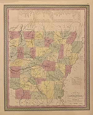
A New Map of Arkansas with its Canals Roads & Distances
Verlag: Thomas, Cowperthwait & Co, Philadelphia, 1850
Anbieter: Argosy Book Store, ABAA, ILAB, New York, NY, USA
Verkäuferbewertung 5 von 5 Sternen
unbound. Zustand: very good(+). Map. Engraving with original hand coloring. Image measures 14.5" x 11.75". Concise map of Arkansas divided into counties showing railroads, major routes and towns. A statistical table lists steam boat routes. Published in "A New Universal Atlas". Thomas, Cowperthwait & Co. took over publication of S. A. Mitchell's important "Universal Atlas" in 1850, and continued to produce updated maps that were considered some of the best commercial cartography of the 19th century. Minor glue residue to top and bottom margins, stain to top edge.
-
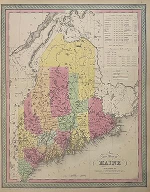
A New Map of Maine
Verlag: Thomas, Cowperthwait & Co, Philadelphia, 1850
Anbieter: Argosy Book Store, ABAA, ILAB, New York, NY, USA
Verkäuferbewertung 5 von 5 Sternen
unbound. Map. Engraving with original hand coloring. Image measures 15" x 12". Nice map of Maine divided into counties showing towns, major routes, waterways and railroads. Includes a table in the upper left corner showing counties and their populations in 1840 and 1850, as well as population growth of the state from 1765 to 1850. In very good condition. Thomas, Cowperthwait & Co. took over publication of S. A. Mitchell's important "Universal Atlas" in 1850, and continued to produce updated maps that were considered some of the best commercial cartography of the 19th century.
-
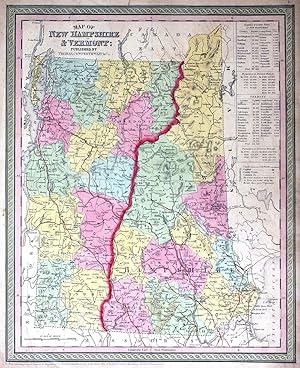
Map of New Hampshire and Vermont
Verlag: Thomas, Cowperthwait & Co., Philadelphia, 1850
Anbieter: Antipodean Books, Maps & Prints, ABAA, Garrison, NY, USA
Verbandsmitglied: ABAA ANZAAB ESA ILAB
Verkäuferbewertung 4 von 5 Sternen
Maps. Zustand: Very good overall. Map of New Hampshire and Vermont, with counties marked, travel information (distances, railroads, steamboat routes in states served by them, population, canals, capitals, county towns, etc.) Approx. 12 1/2 x15 1/2". From the "New Universal Atlas containing Maps of the various Empires, Kingdoms, States and Republics of the World with a special map of each of the United States Plans of Cities & c." Chromolithographs with printed color. A little tanned, edges a little ruffled, o/w minor faults generally in the margins.
-
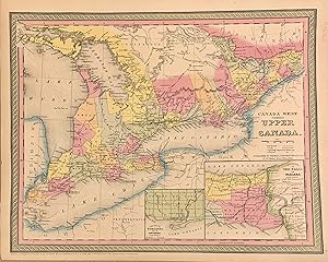
Canada West Formerly Upper Canada
Verlag: Cowperthwait, Philadelphia, 1852
Anbieter: Argosy Book Store, ABAA, ILAB, New York, NY, USA
Verkäuferbewertung 5 von 5 Sternen
unbound. Map. Lithograph with original hand coloring. Image measures 14" x 17". This lovely 1852 map of Ontario, Canada depicts the province in its entirety. The map includes part of New York State as well. "Canada West," previously known as "Upper Canada" is color coded at the district level and notes railroads, cities, rivers, mountains, and other important topographic elements. An inset in the lower right features Vicinity of the Falls of Niagara as well as an inset of the City of Toronto and it's Environs The map is in good condition. Thomas, Cowperthwait & Co. took over publication of S. A. Mitchell's important "Universal Atlas" in 1850, and continued to produce updated maps that were considered some of the best commercial cartography of the 19th century.
-

Map of Connecticut
Verlag: Thomas, Cowperthwait & Co, Philadelphia, 1853
Anbieter: Argosy Book Store, ABAA, ILAB, New York, NY, USA
Verkäuferbewertung 5 von 5 Sternen
unbound. Map. Engraving with original hand coloring. Image measures 12 3/8" x 14 7/8". Great map of Connecticut divided into counties showing railroads, major routes and notable buildings. Rail roads are delineated by hand in orange. A statistical table lists population in various towns, counties and eras. Insets of Hartford and New Haven. Published in "A New Universal Atlas." In good condition, with minor wear to margins. Thomas, Cowperthwait & Co. took over publication of S. A. Mitchell's important "Universal Atlas" in 1850, and continued to produce updated maps that were considered some of the best commercial cartography of the 19th century.
-

A New Map of Georgia with its Roads & Distances
Verlag: Thomas, Cowperthwait, & Co, Philadelphia, 1850
Anbieter: Argosy Book Store, ABAA, ILAB, New York, NY, USA
Verkäuferbewertung 5 von 5 Sternen
unbound. Map. Engraving with original hand coloring. Image measures 14" x 11 1/2" Beautifully detailed map of Georgia divided into counties. The map delineates towns, waterways, railroads, and major routes, as explained in a small key below the title. Canals and railroads are marked. Includes table of distances along steam boat routes, from Savannah to Augusta, and Savannah to Charleston. In excellent condition. Thomas, Cowperthwait & Co. took over publication of S. A. Mitchell's important "Universal Atlas" in 1850, and continued to produce updated maps that were considered some of the best commercial cartography of the 19th century.
-

Philadelphia
Verlag: Thomas Cowperthwait, New York, 1850
Anbieter: Argosy Book Store, ABAA, ILAB, New York, NY, USA
Verkäuferbewertung 5 von 5 Sternen
unbound. Map. Engraving with original hand coloring. Page measures 16.5" x 13". This vibrantly colored city plan or town plan of Philadelphia, Pennsylvania published in circa 1850 is one of the most beautiful maps of Philadelphia to be included in a 19th century atlas. Map features center city Philadelphia, between the Delaware and Schuylkill Rivers, and extending from Columbia Avenue in the north, to Jackson Avenue in the south along the Delaware River. Shows streets, notable buildings, parks, railroads, and ferry and steamboat routes. The map is in good condition. Thomas, Cowperthwait & Co. took over publication of S. A. Mitchell's important "Universal Atlas" in 1850, and continued to produce updated maps that were considered some of the best commercial cartography of the 19th century.
-
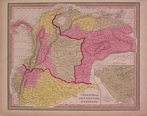
Venezuela, New Granada & Ecuador
Verlag: Thomas, Cowperthwait & Co, Philadelphia, 1846
Anbieter: Argosy Book Store, ABAA, ILAB, New York, NY, USA
Verkäuferbewertung 5 von 5 Sternen
unbound. Zustand: very good. Map. Engraving with original hand coloring. Image measures 12.25" x 15.25". Map of the north eastern portion of South America. Shows what is now known as Colombia as New Granada. Includes an inset of a "Plan of a proposed communication between the Atlantic & Pacific Oceans." Crease at lower left corner. Thomas, Cowperthwait & Co. took over publication of S. A. Mitchell's important "Universal Atlas" in 1850, and continued to produce updated maps that were considered some of the best commercial cartography of the 19th century.
-
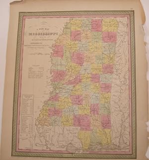
A New Map Of Mississippi With Its Roads & Distances. Color Map.
Verlag: Philadelphia: Thomas Cowperthwait., 1850
Anbieter: Wittenborn Art Books, San Francisco, CA, USA
Verkäuferbewertung 4 von 5 Sternen
Manuskript / Papierantiquität
Zustand: Good. Printed Color Map. 13.5" x 17" Good with tears and minor losses along edges.
-

Map of West Indies
Verlag: Thomas, Cowperthwait & Co., Philadelphia, 1850
Anbieter: Antipodean Books, Maps & Prints, ABAA, Garrison, NY, USA
Verbandsmitglied: ABAA ANZAAB ESA ILAB
Verkäuferbewertung 4 von 5 Sternen
Maps. Zustand: Very good overall. Map of West Indies. Approx. 12 1/2 x15 1/2". From the "New Universal Atlas containing Maps of the various Empires, Kingdoms, States and Republics of the World with a special map of each of the United States Plans of Cities & c." Chromolithographs with printed color. A little tanned.
-

A New Map of Louisiana with its Canals, Roads & Distances from place to place, along the Stage & Steam Boat Routes
Verlag: Thomas, Cowperthwait & Co, 1855
Anbieter: Argosy Book Store, ABAA, ILAB, New York, NY, USA
Verkäuferbewertung 5 von 5 Sternen
unbound. Map. Engraving with original hand coloring. Image measures 11 1/2" x 14 3/8" Beautiful map of Louisiana divided into counties. Shows towns, major routes and waterways. Canals and railroads are delineated. Wetlands are depicted pictorially. Includes inset featuring a town plan of New Orleans, showing streets and streetcar lines, with faubourgs and major buildings labeled. A table provides information about steam boat routes from New Orleans to Pittsburg, Natchitoches, and Balize with distances. Thomas, Cowperthwait & Co. took over publication of S. A. Mitchell's important "Universal Atlas" in 1850, and continued to produce updated maps that were considered some of the best commercial cartography of the 19th century.
-
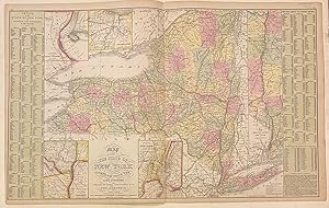
Map of the State of New York compiled from the latest authorities
Verlag: Desilver, Charles, Philadelphia, 1855
Anbieter: Argosy Book Store, ABAA, ILAB, New York, NY, USA
Verkäuferbewertung 5 von 5 Sternen
unbound. Map. Engraving with original hand coloring. Image measures 16 1/8" x 26 1/4" Fascinating map of New York divided into counties. Shows towns, major routes, railroads, waterways, and topographical features. Insets include the vicinities of Albany, New York City, Rochester, and Niagara Falls, and a Map of the Hudson River from New York to Albany. On either side of the map is a table listing populations of counties and townships, square miles of counties, and other miscellaneous statistics. From the "New Universal Atlas". Plate was originally published by Samuel Augustus Mitchell, who sold the copyright to Thomas, Cowperthwait & Company in 1850, which was in turn bought by Charles Desilver in 1856. Thomas, Cowperthwait & Co. took over publication of S. A. Mitchell's important "Universal Atlas" in 1850, and continued to produce updated maps that were considered some of the best commercial cartography of the 19th century.
-

A New Map of the State of Ohio
Verlag: Thomas, Cowperthwait & Co, Philadelphia, 1852
Anbieter: Argosy Book Store, ABAA, ILAB, New York, NY, USA
Verkäuferbewertung 5 von 5 Sternen
unbound. Map. Engraving with original hand coloring. Image measures 15 3/4" x 13". Classic map of Ohio divided into counties. Shows towns, major routes, railroads, canals and rivers. Includes profiles of the Miami and Ohio & Erie Canals. From the "New Universal Atlas". Plate was originally published by Samuel Augustus Mitchell, who sold the copyright to Thomas, Cowperthwait & Company in 1850, which was in turn bought by Charles Desilver in 1856. Minor chipping to left edge.
-

Map of New Jersey reduced from T. Gordon's Map
Verlag: Thomas, Cowperthwait & Co, Philadelphia, 1852
Anbieter: Argosy Book Store, ABAA, ILAB, New York, NY, USA
Verkäuferbewertung 5 von 5 Sternen
unbound. Zustand: very good. Map. Engraving with original hand coloring. Image measures 15" x 12 5/8". Beautifully detailed map of New Jersey divided into counties. Shows towns, major routes, railroads (proposed and existing), and waterways (including canals). A table at left lists distances from Trenton, and at right, a table of populations. From the "New Universal Atlas". Plate was originally published by T. Gordon, and later by Samuel Augustus Mitchell, who sold the copyright to Thomas, Cowperthwait & Company in 1850. Some toning, minimal chips to edges.
-

A New Map of Virginia with its Canals, Roads, & Distances from place to place, along the Stage and Steam Boat Routes
Verlag: Thomas, Cowpertwaith & Co, Philadelphia, 1854
Anbieter: Argosy Book Store, ABAA, ILAB, New York, NY, USA
Verkäuferbewertung 5 von 5 Sternen
unbound. Map. Engraving with original hand coloring. Image measures 12 3/4" x 15 3/4" Lovely map of Virginia, including West Virginia, divided into counties. Shows major cities, major routes, waterways and railroads. Includes table of steam boat routes. Includes an inset in the top right showing a profile of the Chesapeake & Ohio Canal. This map was published in the "New Universal Atlas", and is in very good condition. Plate was originally published by Samuel Augustus Mitchell, who sold the copyright to Thomas, Cowperthwait & Company in 1850, which was in turn bought by Charles Desilver in 1856. Thomas, Cowperthwait & Co. took over publication of S. A. Mitchell's important "Universal Atlas" in 1850, and continued to produce updated maps that were considered some of the best commercial cartography of the 19th century.
-

A New Map of Nth. Carolina with its Canals, Roads & Distances from place to place, along the Stage & Steam Boat Routes
Verlag: Thomas, Cowperthwait & Co, Philadelphia, 1852
Anbieter: Argosy Book Store, ABAA, ILAB, New York, NY, USA
Verkäuferbewertung 5 von 5 Sternen
unbound. Map. Engraving with original hand coloring. Image measures 11 1/2" x 14". Beautifully detailed map of North Carolina divided into counties. Delineates towns, waterways, railroads and major routes. Includes insets of Craven and the Gold Region as well as a profile of the "Dismal Swamp Canal". Minor overall toning, slight tape residue along top and bottom edges, small tear to right edge. Thomas, Cowperthwait & Co. took over publication of S. A. Mitchell's important "Universal Atlas" in 1850, and continued to produce updated maps that were considered some of the best commercial cartography of the 19th century.
-

A New Map of Kentucky with its Roads & Distances
Verlag: Thomas, Cowpertwaith & Co, Philadelphia, 1854
Anbieter: Argosy Book Store, ABAA, ILAB, New York, NY, USA
Verkäuferbewertung 5 von 5 Sternen
unbound. Map. Engraving with original hand coloring. Image measures 11 3/4" x 14" Nice clean map of Kentucky divided into counties. Shows major cities, major routes, waterways and railroads. Includes table of steam boat routes. Includes insets showing larger scale depictions of roads surrounding Lexington, and along the Ohio River near Clarksburg, and at the Falls of Ohio near Louisville. A table in the upper right corner indicates steam boat routes from Louisville to Pittsburgh, and from Louisville to New Orleans. From the "New Universal Atlas". In very good condition with minor wear to margins, not affecting the image. Plate was originally published by Samuel Augustus Mitchell, who sold the copyright to Thomas, Cowperthwait & Company in 1850, which was in turn bought by Charles Desilver in 1856.
