Gesamtpreis (1 Artikel Artikel):
Versandziel:

commodore matthew calbraith perry (5 Ergebnisse)
Direkt zu den wichtigsten Suchergebnissen
Suchfilter
Produktart
- Alle Product Types
- Bücher (5)
- Magazine & Zeitschriften (Keine weiteren Ergebnisse entsprechen dieser Verfeinerung)
- Comics (Keine weiteren Ergebnisse entsprechen dieser Verfeinerung)
- Noten (Keine weiteren Ergebnisse entsprechen dieser Verfeinerung)
- Kunst, Grafik & Poster (Keine weiteren Ergebnisse entsprechen dieser Verfeinerung)
- Fotografien (Keine weiteren Ergebnisse entsprechen dieser Verfeinerung)
- Karten (Keine weiteren Ergebnisse entsprechen dieser Verfeinerung)
- Manuskripte & Papierantiquitäten (Keine weiteren Ergebnisse entsprechen dieser Verfeinerung)
Zustand Mehr dazu
- Neu (Keine weiteren Ergebnisse entsprechen dieser Verfeinerung)
- Wie Neu, Sehr Gut oder Gut Bis Sehr Gut (1)
- Gut oder Befriedigend (1)
- Ausreichend oder Schlecht (Keine weiteren Ergebnisse entsprechen dieser Verfeinerung)
- Wie beschrieben (3)
Einband
Weitere Eigenschaften
- Erstausgabe (2)
- Signiert (1)
- Schutzumschlag (Keine weiteren Ergebnisse entsprechen dieser Verfeinerung)
- Angebotsfoto (4)
Sprache (2)
Preis
- Beliebiger Preis
- Weniger als EUR 20 (Keine weiteren Ergebnisse entsprechen dieser Verfeinerung)
- EUR 20 bis EUR 45
- Mehr als EUR 45
Gratisversand
- Kostenloser Versand nach USA (Keine weiteren Ergebnisse entsprechen dieser Verfeinerung)
Land des Verkäufers
Verkäuferbewertung
-

Narrative of the Expedition to the China Seas and Japan, 1852-1854
Anbieter: Joseph Burridge Books, Dagenham, Vereinigtes Königreich
Verkäuferbewertung 5 von 5 Sternen

EUR 35,41
EUR 26,36 Versand
Versand von Vereinigtes Königreich nach USAAnzahl: 1 verfügbar
In den WarenkorbSoft cover. Zustand: Fine. xvii, 537 pages : illustrations, maps ; 28 cm. Summary:Enhanced with over 200 rare illustrations, this thrilling firsthand account relates the tension and triumph attendant upon Perry's mission to establish Japanese-American diplomatic relations. Drawn from the journals of the commodore and his officers, the narrative also features entries from diaries and official correspondence and reports, all brimming with revealing anecdotes.
-

[I]. NARRATIVE OF THE EXPEDITION OF AN AMERICAN SQUADRON TO THE CHINA SEAS AND JAPAN, PERFORMED IN THE YEARS 1852, 1853, AND 1854, UNDER THE COMMAND OF COMMODORE M. C. PERRY, UNITED STATES NAVY, BY ORDER OF THE GOVERNMENT OF THE UNITED STATES. - COMPILED FROM THE ORIGINAL NOTES AND JOURNALS OF COMMODORE PERRY AND HIS OFFICERS, at his Request, and under his Supervision, by Francis L. Hawks, D.D. L.L.D.; WITH NUMEROUS ILLUSTRATIONS*. --- SENATE EDITION, P. G. WASHINGTON'S COPY; INSCRIBED BY HIM to then German U.S. Ambassador Friedrich Karl Joseph Freiherr von Gerolt. / II. 33rd Congress, 2nd Session: REPORTS ON NATURAL HISTORY AND ECONOMIC GEOGRAPHY incl. the Facsimile of the 'Treaty of Kanagawa'. / III 'UNITED STATES JAPAN EXPEDITION: OBSERVATIONS ON THE ZODIACAL LIGHT, from April 2, 1853, to April 22, 1855, made chiefly on Board the United States Steam-Frigate Mississippi, during her late Cruise in Eastern Seas, and her Voyage homeward; with Conclusions from the Data thus obtained.'. -
Verlag: Washington, Beverley Tucker - Senate Printer (I/III) / A.O.P. Nicholson (House Printer), 1856/1857., 1857
Anbieter: C O - L I B R I , Bremen - Berlin ; Deutschland / Germany ., Berlin, Deutschland
Verkäuferbewertung 5 von 5 Sternen
Erstausgabe
I. 2 blank sheets, XVII (I); 537 pages, with 78 xylographic illustrations in the text; 86 singleside-printed toned or colour-lithographic plates (incl. portraits after Daguerreotypes by Eliphalet Brown) and 3 foldout-colourplates of japanese woodblock-prints (89 plates in total) and 3 geographical maps (1 foldout) bound within; 2 blank sheets. / II. (House Edition, 1857). (8) 414, (1) 14 pages ('Treaty of Ka-na-ga-wa'[Kanagawa], the first document ever negotiated by the Empire of Japan with any western nation according to International Law), (1) XI (1) p.; some xylographic text-illustrations, 4 (3 coloured) lithographic plates 'Agriculture of China', 22 (of 23, 17 [hand-]coloured) plates of Natural History (Yack, Japanese Fox), Ornithology (Japanese Birds, 5 of 6), Ichthyology (Japanese Fishes, 10), Conchyology (Japanese Shells, 5); 3 (2 folded) maps in the text, 16 plates with meteorological diagrams; 15 of 17 very large multiple folded maps at the end. / III. XLIII, 705 pages with 365 (of 366) astronomic xylographic plates (lacking plate 66); all plates in I and II on singleside printed cardboards. - I. Thick and heavy 'night-blue' full morocco-binding of the period over 4 raised bands with gilt-ornamental frames at panels and bands and gilt title and owner's name ('P. G. Washington') at bottom-of-spine, colour-marbled endpapers; II./III. Blind-tooled (naval motive) publisher's cloth bindings; lex.-4to.(ca. 31 x 23 x 20 cm; ca. 9 kg.). *** [FRÜHLINGSVERKAUF-Endspurt, noch bis Montag den 18.05.2026 / Ultimate SPRING-SALE, only until Monday May 18th 2026: um über 45% REDUZIERTER PREIS / PRICE-REDUCTION of over 45%; ehemaliger Preis / previously EUR 1.800,-] --- (Sabin #30958, Cordier 'Japonica' #513, Nissen ZBI #3132) I. FIRST EDITION, BIBLIOPHILE BOUND ORIGINAL; THE SENATE-EDITION (Senate executive Documents #34 of 33rd Congress, 2nd Session), published parrallel to Nicholson's 'House-Editon'. - FIRST BLANK SHEET WITH 4-LINE INSCRIPTION ''to Baron Gerolt / with the kind regards / of P. G. Washington / Feby. 16 1857''. Peter Grayson Washington (1798-1872), son of the Nephew of a Cousin of George Washington (1732-1799, American Founding Father and first President of the United States) served as 'Assistant Secretary of the Treasury Virginia New York City'; Friedrich Karl Joseph Freiherr von Gerolt (1797-1879) was the German-Prussian 'Envoy Extraordinary and Minister Plenipotentiary in the United States' and has been the longest-ever serving ambassador of Germany in the U.S. In the quarter+ century of service, Gerolt met presidents James K. Polk, Zachary Taylor, Millard Fillmore, Franklin Pierce, James Buchanan, Abraham Lincoln, Andrew Johnson and Ulysses Grant. As a studied mining geologist (Freiberg Mining Academy) in ''1824 he travelled to Mexico as an agent of the German-American Mining Association, where significant silver mines were suspected. Together with Carl de Berghes, also an Mining Association Agent, he published the 'Carta geognostica de los principales distritos minerales del Estado de Mexico' in 1827 with Arnz & Comp., a special mineralogical map of central Mexico, which is considered the first geological map of Mexico printed in colour.''(german wikipedia). - Corners of the leather-binding partly somewhat rubbed, panels slightly rubbed and slightly scratched; some textpages opposite of lithographic plates with slight offsetting (shadow) last sheets with slim humidity-stain at top sharp-corner, last 10 sheets (incl. rear endpaper) with small hole in the blank bottom margin; A MAGNIFICIENT COPY WITH A 'WELL NAMED' ASSOCIATION OF THE PERIOD. --- II. Binding somewhat rubbed, lacks plate 6 of Ornithology and textpages 257-262 (beginning of Ichthyology); Acceptably used. / III. Binding rubbed, many pages with humiditystain at foreedge or top sharp-corner (growing towards the end), lacks zodiac-plate #66 (of 352). --- MAIN OFFER IS THE LUXOURIUS EQUIPPED AND COMPLETE HISTORIC ASSOCIATION COPY OF VOLUME I; Vols. II and III have been added from another set to create scientific completeness (more or less). . .
-
Presentation of the relics of Commodore Matthew Calbraith Perry by his descendants to the people of Japan through the American ambassador
Verlag: The America-Japan Society, June, Tokio, 1928
Anbieter: Rulon-Miller Books (ABAA / ILAB), St. Paul, MN, USA
Verbandsmitglied: ABAA ILAB RMABA
Verkäuferbewertung 5 von 5 Sternen
Only edition, 8vo, pp. [2], 39, [1]; 12 full-page illustrations from photographs including a fine portrait of Perry, other dignitaries, and the relics themselves; original printed gray wrappers, soiled, the top 3" of the upper joint torn; a good copy of an uncommon Perry item. Ten in OCLC: Arkansas, Stanford, Yale, LC, Chicago, Harvard, LC, US Dept. of State, Swarthmore, and Alberta.
-
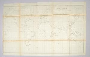
Chart of the World shewing the Track of the U.S. Steam Frigates, Mississippi, Susquehanna and Powhatan as Flagships of the Japan Squadron under the command of Commodore M.C. Perry, U.S.N., 1853-54 World Map 1854
Verlag: Hydrographic Office c1854., United States., 1854
Anbieter: Asia Bookroom ANZAAB/ILAB, Canberra, ACT, Australien
Verkäuferbewertung 5 von 5 Sternen
Signiert
Large black and white folded map. Some browning at the folds, some fold lines have been repaired with archival tape but overall in good condition. Scale 1:37,000,000. 54 x 91 cm "In January 1852 Perry was selected to undertake the most important diplomatic mission ever entrusted to an American naval officer, the negotiation of a treaty with Japan, a country at this time sealed against intercourse with the Occidental powers" (DAB). By March 31, 1854, the treaty granting the U.S. trading rights had been signed by the Japanese. Drawn by Edward. Sels and engraved by Selmar Siebert this map was issued as part of the United States Naval Expedition to Japan, 1852-1854. Shows the route of the US Steam Frigates Mississippi, Susquehanna and Powhatan. Some regions such as Antarctica and Enderbury's Land appear to be un-explored, Tasmania appears at Van Diemen's Land.
-
NARRATIVE OF THE EXPEDITION OF AN AMERICAN SQUADRON TO THE CHINA SEAS AND JAPAN, Performed in the Years 1852, 1853, and 1854 - Volume 2 Only But with the Illustrations from Volumes 1 and 3
Verlag: Nicholson, Washington, 1856
Anbieter: Charles Parkhurst Rare Books, Inc. ABAA, Surprise, AZ, USA
Verbandsmitglied: ABAA ILAB RMABA
Verkäuferbewertung 5 von 5 Sternen
Erstausgabe
Zustand: Very Good+. First Edition. Small Folio. House issue, of this most important expedition, led by Commodore Perry, which opened Japan to the West. original cloth, volume 2 only, but with the illustrations from volumes 1 and 2, unbound; lacking the "suppressed" NUDE BATHING PLATE. Vol. II shows minor wear at extremities, small loss at spine ends and small stain at lower margin of first 100 pages, not affecting text; cloth darkened at lower front board. Overall very good. Lacks chart showing tracks of hurricanes at page 354. Plates are very good to fine. Neat owner name and date on title page. Folding maps bound in at rear.