Colonel mudge (8 Ergebnisse)

- Softcover
Anbieter: Ria Christie Collections, Uxbridge, Vereinigtes KönigreichRia Christie Collections
Verkäufer/-in kontaktierenVerkäufer/-in mit 5 SternenZustand: Neu
EUR 38,38
EUR 13,88 VersandVersand von Vereinigtes Königreich nach USAAnzahl: Mehr als 20 verfügbar
Zustand: New. In.
 Weitere Bilder
Sprache: Englisch
Verlag: James Wyld, London 1865
- Hardcover
- Karte
Anbieter: Dendera, London, Vereinigtes KönigreichDendera
Verkäufer/-in kontaktierenVerkäufer/-in mit 5 SternenZustand: Gebraucht - Befriedigend
EUR 149,19
EUR 28,97 VersandVersand von Vereinigtes Königreich nach USAAnzahl: 1 verfügbar
Hardcover. Zustand: Good. Coloured travelling map 98 x 68cm dissected into 36 sections and backed on to linen, folding down into its original dark green cloth slipcase 12 x 18cm with Wyld's label to the front (James Wyld Cartographer to Her Majesty, 452 Strand.). Sheet No. VI "Published 1st Jan by Col Mudge, Tower. Electrotyped…in 1865. Price 2/6. Engraved at the Drawing Room in the Tower under the Direction of Col. Mudge by Benjn. Baker and Assistants. The writing by Ebenr. Bourne". Scale: 1 inch to the mile (a second scale in Furlongs). Coverage: Penge Common (NW) - Southfleet (N) - Chitney Marsh (NE) - Lenham (E) - High Halden (SE) - Eridge New and Old Park (S) - Godstone (W). Paper very good, lightly dusted and marked. Linen tanned and stained. Slipcase good only, marked with wear to extremities and darkening and wear to label.
 Weitere Bilder
Map of Surrey [folded]
Engraved at the Drawing Room in the Tower under the Direction of Colonel Mudge by Benj. Baker & Assistants, writing by Eben. Bourne.
Verlag: Colonel Mudge / Sold by Letts, Son and Co, 8 Royal Exchange, E.C. Map, Chart & Globe Sellers. Agents by Appointment for the Sale of Ordnance Maps. 1816
- Softcover
- Karte
Anbieter: Gwyn Tudur Davies, Aberystwyth, Vereinigtes KönigreichGwyn Tudur Davies
Verkäufer/-in kontaktierenVerkäufer/-in mit 5 SternenZustand: Gebraucht - Befriedigend
EUR 113,38
EUR 14,48 VersandVersand von Vereinigtes Königreich nach USAAnzahl: 1 verfügbar
Soft cover. Zustand: Good. No Jacket. 1 folded linen backed map of Surrey. Engraved at the Drawing Room in the Tower under the Direction of Colonel Mudge by Benj. Baker & Assistants, writing by Eben. Bourne. Published on the 1st May, 1816 by Colonel Mudge. Scale in furlongs and miles. Some foxing and old water-stain on verso of…map, also some tanning along fold marks of map o/w a very clean copy in good condition. e1041 / m11777.
 Weitere Bilder
Verlag: Published by James Wyld and the Ordnance Survey, The TowerLondon 1869
- Hardcover
- Karte
Anbieter: Keoghs Books, Skipton, Vereinigtes KönigreichKeoghs Books
Verkäufer/-in kontaktierenVerkäufer/-in mit 5 SternenVerbandsmitglied: PBFA
Zustand: Gebraucht
EUR 113,38
EUR 32,44 VersandVersand von Vereinigtes Königreich nach USAAnzahl: 1 verfügbar
, folding map with 36 sections, linen-backed, 100 x 68 cm opened, hand-coloured borders, railway lines, and parks, covers Wokingham at top left corner, Croydon top right, Woolmer Forest bottom left, and Crawley bottom right, printed from an electrotype taken in 1869, first published 1816 by the Ordnance Survey,1 1/4 inches to a…mile Reprint , a few small spots otherwise map clean and complete, in very good condition, case a little rubbed at corners, very good condition , dark blue cloth case with original printed paper title label to side 17 x 12 cm Hardback ISBN.

Verlag: James Wyld, London 1876 1876
- Softcover
- Karte
Anbieter: ROBIN SUMMERS BOOKS LTD, Aldeburgh, Vereinigtes KönigreichROBIN SUMMERS BOOKS LTD
Verkäufer/-in kontaktierenVerkäufer/-in mit 5 SternenZustand: Gebraucht - Gut
EUR 119,35
EUR 33,60 VersandVersand von Vereinigtes Königreich nach USAAnzahl: 1 verfügbar
Zustand: Very Good. Paperback. Large folding, linen-backed map, 40 x 25 inches, scale 1 inch to 1 mile. One small mark, otherwise clean, very good indeed. Original cloth-backed case slightly worn and faded with label over original printed label. 1876 reproduction from the 1816 original.
 Weitere Bilder
Verlag: Published by Ordnance Survey, London 1875
- Hardcover
- Karte
Anbieter: Keoghs Books, Skipton, Vereinigtes KönigreichKeoghs Books
Verkäufer/-in kontaktierenVerkäufer/-in mit 5 SternenVerbandsmitglied: PBFA
Zustand: Gebraucht
EUR 179,02
EUR 32,44 VersandVersand von Vereinigtes Königreich nach USAAnzahl: 1 verfügbar
, large folding map measuring 125 x 162 cm, scale of 1 inch to 1 statue mile, engraved at the drawing room in the tower under the direction of Col Mudge by Benj. Baker & Assistants - the writing by Eben Bourne, originally published 11th Aug 1817 by Col Mudge, Tower. This version printed from an electrotype taken in 1875 Later ed…ition , Patches of light brown staining to map, no tears, map in very good condition , with slip case in just good condition , Folding cloth backed map 26 x 17 cm Hardback ISBN.
 Weitere Bilder
Verlag: Published by The Ordnance Survey, London 1874
- Karte
Anbieter: Keoghs Books, Skipton, Vereinigtes KönigreichKeoghs Books
Verkäufer/-in kontaktierenVerkäufer/-in mit 5 SternenVerbandsmitglied: PBFA
Zustand: Gebraucht
EUR 89,51
EUR 32,44 VersandVersand von Vereinigtes Königreich nach USAAnzahl: 1 verfügbar
, linen backed black and white ordnance survery map, one inch to a mile, South Coast of Devon including Torbay, Exmouth, Sidmout, Lyme Regis and Teignmouth Reprint , slight foxing to linen backing, no slipcase, a few marks, good condition , linen backed map , 66 cm x 98 cm (open), 17 cm x 11 cm (folded) Map ISBN.
 Weitere Bilder
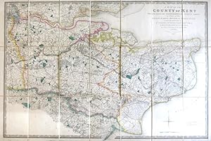
A Map of the County of Kent Drawn from the Topographical Survey Taken, by Order of the Honourable Board of Ordnance, . Reduced from the Large Map in Four Sheets by a Scale of One Inch to Two Statute Miles
(ORDNANCE SURVEY) [under the direction of] MUDGE, Wm., Lt. Colonel
Verlag: London: Jas. Wyld 1841
- Karte
Anbieter: Bow Windows Bookshop (ABA, ILAB), Lewes, Vereinigtes KönigreichBow Windows Bookshop (ABA, ILAB)
Verkäufer/-in kontaktierenVerkäufer/-in mit 5 SternenZustand: Gebraucht
EUR 352,08
EUR 25,49 VersandVersand von Vereinigtes Königreich nach USAAnzahl: 1 verfügbar
Map dimensions 59.5 x 89 cm, overall 63.5 x 94.5 cm. Finely engraved folding map of the county, dissected into twenty-four sections and mounted on linen, green silk trim to the edges, marbled paper to the folded end sections, folds into original green embossed cloth slipcase with Wyld's printed label to upper board and brief tit…le label to one spine. Some mild wear to the corners of the case, a lovely example overall. Kent was the first of the Ordnance Survey maps to be published, appearing in 1801. This version, reduced in format and scale, was first published by Faden in 1807 and then by his successors, the Wylds, at intervals through to the mid-19th century.


