
Gesamtpreis (1 Artikel Artikel):
Versandziel:

close colonel charles (14 Ergebnisse)
Direkt zu den wichtigsten Suchergebnissen
Suchfilter
Produktart
- Alle Product Types
- Bücher (13)
- Magazine & Zeitschriften (Keine weiteren Ergebnisse entsprechen dieser Verfeinerung)
- Comics (Keine weiteren Ergebnisse entsprechen dieser Verfeinerung)
- Noten (Keine weiteren Ergebnisse entsprechen dieser Verfeinerung)
- Kunst, Grafik & Poster (Keine weiteren Ergebnisse entsprechen dieser Verfeinerung)
- Fotografien (Keine weiteren Ergebnisse entsprechen dieser Verfeinerung)
- Karten (1)
- Manuskripte & Papierantiquitäten (Keine weiteren Ergebnisse entsprechen dieser Verfeinerung)
Zustand Mehr dazu
- Neu (Keine weiteren Ergebnisse entsprechen dieser Verfeinerung)
- Wie Neu, Sehr Gut oder Gut Bis Sehr Gut (1)
- Gut oder Befriedigend (8)
- Ausreichend oder Schlecht (Keine weiteren Ergebnisse entsprechen dieser Verfeinerung)
- Wie beschrieben (5)
Einband
Weitere Eigenschaften
- Erstausgabe (Keine weiteren Ergebnisse entsprechen dieser Verfeinerung)
- Signiert (Keine weiteren Ergebnisse entsprechen dieser Verfeinerung)
- Schutzumschlag (2)
- Angebotsfoto (14)
Sprache (1)
Preis
- Beliebiger Preis
- Weniger als EUR 20
- EUR 20 bis EUR 45
- Mehr als EUR 45 (Keine weiteren Ergebnisse entsprechen dieser Verfeinerung)
Gratisversand
- Kostenloser Versand nach USA (Keine weiteren Ergebnisse entsprechen dieser Verfeinerung)
Land des Verkäufers
Verkäuferbewertung
-
The Early Years of the Ordnance Survey
Verlag: Chatham. Published by the Institution of Royal Engineers. 1926, 1926
Anbieter: J. Patrick McGahern Books Inc. (ABAC), Ottawa, ON, Kanada
Verkäuferbewertung 4 von 5 Sternen

hard cover. tall 8vo, 24.5cm, 157p., frontis, 15 illustrations, dark blue cloth, gilt titles on spine & front, near fine (cmt). - A history of the Ordnance Survey between 1746 and 1846 reprinted from the "Royal Engineers Journal". The first ordnance map issued for public use by the Survey was of Kent, in 1795.
-

The Early Years of the Ordnance Survey
Verlag: Published by David & Charles Ltd., Brunel House, Newton Abbot, Devon Reprinted Edition . 1969., 1969
Anbieter: Little Stour Books PBFA Member, Canterbury, Vereinigtes Königreich
Verbandsmitglied: PBFA
Verkäuferbewertung 5 von 5 Sternen

EUR 9,52
EUR 34,64 Versand
Versand von Vereinigtes Königreich nach USAAnzahl: 1 verfügbar
In den WarenkorbZustand: Very Good. Reprinted edition hard back binding in publisher's original tangerine cloth covered boards, blocked and lettered gilt back. 8vo. 8˝'' x 6''. Contains (xxxv),164 pp with monochrome and maps and illustrations throughout. Fine condition book in Very Good condition dust wrapper with sun fading down the spine. Member of the P.B.F.A. CARTOGRAPHY, MAPS, PLANS.
-
![Bild des Verkäufers für Ordnance Survey Contoured Road Map [One Inch to One Mile Popular Edition] Boscastle and Padstow | Sheet 136 zum Verkauf von Little Stour Books PBFA Member](https://pictures.abebooks.com/inventory/md/md31425290728.jpg)
Ordnance Survey Contoured Road Map [One Inch to One Mile Popular Edition] Boscastle and Padstow | Sheet 136
Verlag: Published by Colonel Sir Charles Close and Printed at the Ordnance Survey Office Southampton Revised Edition . 1919., 1919
Anbieter: Little Stour Books PBFA Member, Canterbury, Vereinigtes Königreich
Verbandsmitglied: PBFA
Verkäuferbewertung 5 von 5 Sternen
EUR 17,84
EUR 34,64 Versand
Versand von Vereinigtes Königreich nach USAAnzahl: 1 verfügbar
In den WarenkorbOriginal russet and beige paper front cover with an illustration by Ellis Martin of a man sitting on a hillside with a map and bicycle, small inset map section. This revised edition first printed in 1919 and without print code). Cloth backed paper folded 21 + 7 half section map opening to 27'' x 24''. Popular Edition Price 2/6. One Inch to One Mile. Splits to the folded lines. Member of the P.B.F.A. CORNWALL (Kernow).
-
![Bild des Verkäufers für Ordnance Survey Contoured Road Map [Half Inch to One Mile Three Shillings Edition] Sheffield | Sheet 13 zum Verkauf von Little Stour Books PBFA Member](https://pictures.abebooks.com/inventory/md/md31425297909.jpg)
Ordnance Survey Contoured Road Map [Half Inch to One Mile Three Shillings Edition] Sheffield | Sheet 13
Verlag: Published by Colonel Sir Charles Close and Printed at the Ordnance Survey Office Southampton . 1927., 1927
Anbieter: Little Stour Books PBFA Member, Canterbury, Vereinigtes Königreich
Verbandsmitglied: PBFA
Verkäuferbewertung 5 von 5 Sternen
EUR 17,84
EUR 34,64 Versand
Versand von Vereinigtes Königreich nach USAAnzahl: 1 verfügbar
In den WarenkorbThe Half-Inch Layered series in green and beige paper front cover with open-top car and signpost illustration by Ellis Martin. First printed in 1915, this is a reprint from 1927 (print code 5000/27). Cloth backed paper folded 24 section map opening to 30'' x 21''. Three Shillings Edition ˝ Inch to 1 Mile. With small slits to the folded cross corners. Member of the P.B.F.A. YORKSHIRE (Jórvík).
-
![Bild des Verkäufers für Ordnance Survey Contoured Road Map [One Inch to One Mile Popular Edition] Whitby and Saltburn | Sheet 16 zum Verkauf von Little Stour Books PBFA Member](https://pictures.abebooks.com/inventory/md/md31425290726.jpg)
Ordnance Survey Contoured Road Map [One Inch to One Mile Popular Edition] Whitby and Saltburn | Sheet 16
Verlag: Published by Colonel Sir Charles Close and Printed at the Ordnance Survey Office Southampton . 1938., 1938
Anbieter: Little Stour Books PBFA Member, Canterbury, Vereinigtes Königreich
Verbandsmitglied: PBFA
Verkäuferbewertung 5 von 5 Sternen
EUR 17,84
EUR 34,64 Versand
Versand von Vereinigtes Königreich nach USAAnzahl: 1 verfügbar
In den WarenkorbOriginal russet and beige paper front cover with an illustration by Ellis Martin of a man sitting on a hillside with a map and bicycle, small inset map section. First printed in 1925, this is a reprint from 1938 (print code 3038). Cloth backed paper folded 21 section map opening to 30'' x 21''. Popular Edition Price 2/6. One Inch to One Mile. Rubbing to the covers, small holes to the cross corners. Member of the P.B.F.A. YORKSHIRE (Jórvík).
-
![Bild des Verkäufers für England Sheet 4 on the Scale of Ľ inch to 1 Mile [Railways Revised to 1913] zum Verkauf von Little Stour Books PBFA Member](https://pictures.abebooks.com/inventory/md/md249100874.jpg)
England Sheet 4 on the Scale of Ľ inch to 1 Mile [Railways Revised to 1913]
Verlag: Published by Ordnance Survey Office Chessington, Surrey . 1913., 1913
Anbieter: Little Stour Books PBFA Member, Canterbury, Vereinigtes Königreich
Verbandsmitglied: PBFA
Verkäuferbewertung 5 von 5 Sternen
EUR 17,84
EUR 34,64 Versand
Versand von Vereinigtes Königreich nach USAAnzahl: 1 verfügbar
In den WarenkorbZustand: Very Good. Folding cloth backed colour map 25" x 31". Foxing to outside covers and edges, no tears and in Very Good clean condition. Member of the P.B.F.A. CARTOGRAPHY, MAPS, PLANS.
-

England Sheet 6 on the Scale of Ľ inch to 1 Mile
Verlag: Published by Ordnance Survey Office Chessington, Surrey . 1913., 1913
Anbieter: Little Stour Books PBFA Member, Canterbury, Vereinigtes Königreich
Verbandsmitglied: PBFA
Verkäuferbewertung 5 von 5 Sternen
EUR 17,84
EUR 34,64 Versand
Versand von Vereinigtes Königreich nach USAAnzahl: 1 verfügbar
In den WarenkorbZustand: Very Good. Folding cloth backed colour map 25" x 31". Foxing to outside covers and edges, no tears and in Very Good clean condition. Member of the P.B.F.A. CARTOGRAPHY, MAPS, PLANS.
-
Text Book Of Topographical And Geographical Surveying
Verlag: His Majestyâs Stationery Office, 1925
Anbieter: Hall of Books, Shropshire, Vereinigtes Königreich
Verkäuferbewertung 5 von 5 Sternen
EUR 35,62
EUR 18,42 Versand
Versand von Vereinigtes Königreich nach USAAnzahl: 1 verfügbar
In den WarenkorbHardback. Zustand: Very Good. Third edition hardback, 1925, with no jacket. In overall very good used condition with only minor signs of age, handling and storage - boards slightly rubbed with a couple of light marks. Binding tight and appears little read. Internally clean, no annotation or inscriptions - ownership signature to front pastedown dated 1940; text, diagrams, maps, tables and plates (some folding) bright and clear throughout. Photographs available. Not an old library book.
-
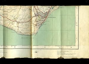
Ordnance Survey Contoured Road Map of Brighton and Eastbourne: Sheet 134
Verlag: Published by Colonel Sir Charles Close and Printed at the Ordnance Survey Office Southampton . London 1920., 1920
Anbieter: Little Stour Books PBFA Member, Canterbury, Vereinigtes Königreich
Verbandsmitglied: PBFA
Verkäuferbewertung 5 von 5 Sternen
EUR 23,79
EUR 34,64 Versand
Versand von Vereinigtes Königreich nach USAAnzahl: 1 verfügbar
In den WarenkorbOriginal russet and beige paper front cover with an illustration by Ellis Martin of a man sitting on a hillside with a map and bicycle, small inset map section. Cloth backed paper folded 24 section map opening to 30'' x 21''. Popular Edition Price 2/6. One Inch to One Mile. Thin brown stain across the horizontal crease lines, no tears. Member of the P.B.F.A. SUSSEX [Eastbourne].
-

Ordnance Survey Contoured Road Map of Hastings | Sheet 135
Verlag: Published by Colonel Sir Charles Close and Printed at the Ordnance Survey Office Southampton . London 1921., 1921
Anbieter: Little Stour Books PBFA Member, Canterbury, Vereinigtes Königreich
Verbandsmitglied: PBFA
Verkäuferbewertung 5 von 5 Sternen
EUR 23,79
EUR 34,64 Versand
Versand von Vereinigtes Königreich nach USAAnzahl: 1 verfügbar
In den WarenkorbZustand: Very Good. Original russet and beige paper front cover with an illustration by Ellis Martin of a man sitting on a hillside with a map and bicycle, small inset map section. Cloth backed paper folded 24 section map opening to 30'' x 21''. Popular Edition Price 2/6. One Inch to One Mile. In Very Good clean and neat condition, no tears. Member of the P.B.F.A. SUSSEX [Hastings].
-

Ordnance Survey One Inch Map Popular Edition of Barmouth and Aberystwyth: Sheet 68
Verlag: Published by Colonel Sir Charles Close and Printed at the Ordnance Survey Office Southampton . London 1922., 1922
Anbieter: Little Stour Books PBFA Member, Canterbury, Vereinigtes Königreich
Verbandsmitglied: PBFA
Verkäuferbewertung 5 von 5 Sternen
EUR 23,79
EUR 34,64 Versand
Versand von Vereinigtes Königreich nach USAAnzahl: 1 verfügbar
In den WarenkorbZustand: Very Good. Original russet and beige paper front cover with an illustration by Ellis Martin of a man sitting on a hillside with a map and bicycle, small inset map section. Cloth backed paper folded 20 section map opening to 22'' x 35''. Popular Edition Price 2/6. One Inch to One Mile. In Very Good clean and neat condition, no tears. Member of the P.B.F.A. WALES & WELSH LITERATURE.
-

Ordnance Survey Contoured Road Map of Torquay and Dartmouth: Sheet 145
Verlag: Published by Colonel Sir Charles Close and Printed at the Ordnance Survey Office Southampton . Southampton 1919., 1919
Anbieter: Little Stour Books PBFA Member, Canterbury, Vereinigtes Königreich
Verbandsmitglied: PBFA
Verkäuferbewertung 5 von 5 Sternen
EUR 26,17
EUR 34,64 Versand
Versand von Vereinigtes Königreich nach USAAnzahl: 1 verfügbar
In den WarenkorbZustand: Very Good. Original russet and beige paper front cover with an illustration by Ellis Martin of a man sitting on a hillside with a map and bicycle, small inset map section. Cloth backed paper folded 24 section map opening to 24'' x 25''. Popular Edition Price 2/6. One Inch to One Mile. In Very Good condition with light soiling to the covers and the folded sections, no tears. Member of the P.B.F.A. DEVONSHIRE (Dumnonia).
-

Ordnance Survey Contoured Road Map of Portmadoc and Criccieth: Sheet 49
Verlag: Published by Colonel Sir Charles Close and Printed at the Ordnance Survey Office Southampton . London 1922., 1922
Anbieter: Little Stour Books PBFA Member, Canterbury, Vereinigtes Königreich
Verbandsmitglied: PBFA
Verkäuferbewertung 5 von 5 Sternen
EUR 35,68
EUR 34,64 Versand
Versand von Vereinigtes Königreich nach USAAnzahl: 1 verfügbar
In den WarenkorbZustand: Very Good. Original russet and beige paper front cover with an illustration by Ellis Martin of a man sitting on a hillside with a map and bicycle, small inset map section. Cloth backed paper folded 36 section map opening to 38'' x 26''. Popular Edition Price 2/6. One Inch to One Mile. In Very Good clean and neat condition, no tears. Member of the P.B.F.A. WALES & WELSH LITERATURE.
-
Contoured Road Map of Bicester
Erscheinungsdatum: 1930
Anbieter: Versandantiquariat Funke, Dresden, Deutschland
Verkäuferbewertung 4 von 5 Sternen
Karte
Zustand: guter bis sehr guter Zustand. guter bis sehr guter Zustand, geringe Gebrauchs- und Alterungsspuren: Umschlag an Ecken und Kanten teils etwas abgenutzt, teils mit kleinen Blessuren - Karte sauber und ordentlich Engraved 1872-1885, published 1887-90, Revisited in 1892 and 1902, Revisited in 1914, printed in 1919, Reprint 1930 Buchreihe: One-Inch Map of Great Britain, Sheet 94 Format: ca. 11 x 19 (Plan aufgeklappt ca. 74 x 56) kartoniert / Papier Englisch.


