Clarence e dutton (38 Ergebnisse)
- Softcover
Anbieter: Kennys Bookstore, Olney, MD, USAKennys Bookstore
Verkäufer/-in kontaktierenVerkäufer/-in mit 5 SternenZustand: Neu
EUR 6,13
EUR 9,13 VersandVersand innerhalb von USAAnzahl: 2 verfügbar
Zustand: New. Written as part of the 1883 Annual Report of the US Geological Survey, this is a comprehensive study of volcanism in Hawai'i. Of both scientific and historical interest, this natural history writing includes a colorful biographical sketch of the author, a discussion of his assignment to Hawai'i, and a list of his p…rincipal writings. Num Pages: 224 pages, 25 illustrations. BIC Classification: 1MKPH; RBC. Category: (UP) Postgraduate, Research & Scholarly; (UU) Undergraduate. Dimension: 229 x 152 x 14. Weight in Grams: 331. . 2005. paperback. . . . . Books ship from the US and Ireland.

- Hardcover
Anbieter: Majestic Books, Hounslow, , Vereinigtes KönigreichMajestic Books
Verkäufer/-in kontaktierenVerkäufer/-in mit 4 SternenZustand: Neu
EUR 23,58
EUR 7,51 VersandVersand von Vereinigtes Königreich nach USAAnzahl: 4 verfügbar
Zustand: New. pp. 370.

- Softcover
Anbieter: PBShop.store US, Wood Dale, IL, USAPBShop.store US
Verkäufer/-in kontaktierenVerkäufer/-in mit 5 SternenZustand: Neu
EUR 32,78
Versand nach gratisVersand innerhalb von USAAnzahl: 15 verfügbar
PAP. Zustand: New. New Book. Shipped from UK. Established seller since 2000.
- Softcover
Anbieter: PBShop.store UK, Fairford, GLOS, Vereinigtes KönigreichPBShop.store UK
Verkäufer/-in kontaktierenVerkäufer/-in mit 5 SternenZustand: Neu
EUR 29,23
EUR 5,80 VersandVersand von Vereinigtes Königreich nach USAAnzahl: 15 verfügbar
PAP. Zustand: New. New Book. Shipped from UK. Established seller since 2000.

- Hardcover
Anbieter: PBShop.store US, Wood Dale, IL, USAPBShop.store US
Verkäufer/-in kontaktierenVerkäufer/-in mit 5 SternenZustand: Neu
EUR 36,80
Versand nach gratisVersand innerhalb von USAAnzahl: 15 verfügbar
HRD. Zustand: New. New Book. Shipped from UK. Established seller since 2000.

- Hardcover
Anbieter: Majestic Books, Hounslow, , Vereinigtes KönigreichMajestic Books
Verkäufer/-in kontaktierenVerkäufer/-in mit 4 SternenZustand: Neu
EUR 32,36
EUR 7,51 VersandVersand von Vereinigtes Königreich nach USAAnzahl: 4 verfügbar
Zustand: New. pp. 370. 42 Color & B/w Plates (illustrator).

- Softcover
Anbieter: Ria Christie Collections, Uxbridge, Vereinigtes KönigreichRia Christie Collections
Verkäufer/-in kontaktierenVerkäufer/-in mit 5 SternenZustand: Neu
EUR 25,86
EUR 13,85 VersandVersand von Vereinigtes Königreich nach USAAnzahl: Mehr als 20 verfügbar
Zustand: New. In.
- Hardcover
Anbieter: PBShop.store UK, Fairford, GLOS, Vereinigtes KönigreichPBShop.store UK
Verkäufer/-in kontaktierenVerkäufer/-in mit 5 SternenZustand: Neu
EUR 37,58
EUR 5,80 VersandVersand von Vereinigtes Königreich nach USAAnzahl: 15 verfügbar
HRD. Zustand: New. New Book. Shipped from UK. Established seller since 2000.

- Hardcover
Anbieter: Ria Christie Collections, Uxbridge, Vereinigtes KönigreichRia Christie Collections
Verkäufer/-in kontaktierenVerkäufer/-in mit 5 SternenZustand: Neu
EUR 34,39
EUR 13,85 VersandVersand von Vereinigtes Königreich nach USAAnzahl: Mehr als 20 verfügbar
Zustand: New. In.

- Hardcover
Anbieter: moluna, Greven, , Deutschlandmoluna
Verkäufer/-in kontaktierenVerkäufer/-in mit 5 SternenZustand: Neu
EUR 33,31
EUR 48,99 VersandVersand von Deutschland nach USAAnzahl: Mehr als 20 verfügbar
Gebunden. Zustand: New.

- Softcover
Anbieter: AHA-BUCH GmbH, Einbeck, DeutschlandAHA-BUCH GmbH
Verkäufer/-in kontaktierenVerkäufer/-in mit 5 SternenZustand: Neu
EUR 28,84
EUR 61,02 VersandVersand von Deutschland nach USAAnzahl: 2 verfügbar
Taschenbuch. Zustand: Neu. Neuware - This groundbreaking work provides a detailed study of the physical geology of the Grand Cañon District-an area that had, up to that point, been largely ignored by geologists. With detailed maps, charts, and photographs, as well as clear explanations of the geological formations found in the a…rea, this book is an important resource for anyone interested in the geological history of the American West.

- Hardcover
Anbieter: AHA-BUCH GmbH, Einbeck, DeutschlandAHA-BUCH GmbH
Verkäufer/-in kontaktierenVerkäufer/-in mit 5 SternenZustand: Neu
EUR 41,49
EUR 61,16 VersandVersand von Deutschland nach USAAnzahl: 2 verfügbar
Buch. Zustand: Neu. Neuware.

- Hardcover
Anbieter: AHA-BUCH GmbH, Einbeck, DeutschlandAHA-BUCH GmbH
Verkäufer/-in kontaktierenVerkäufer/-in mit 5 SternenZustand: Neu
EUR 44,41
EUR 61,88 VersandVersand von Deutschland nach USAAnzahl: 2 verfügbar
Buch. Zustand: Neu. Neuware - This groundbreaking work provides a detailed study of the physical geology of the Grand Cañon District-an area that had, up to that point, been largely ignored by geologists. With detailed maps, charts, and photographs, as well as clear explanations of the geological formations found in the area, th…is book is an important resource for anyone interested in the geological history of the American West.
 Weitere Bilder
Sprache: Englisch
Verlag: Peregrine Smith, Santa Barbara 1977
- Hardcover
Anbieter: Kaaterskill Books, ABAA/ILAB, East Jewett, NY, USAKaaterskill Books, ABAA/ILAB
Verkäufer/-in kontaktierenVerkäufer/-in mit 5 SternenZustand: Gebraucht
EUR 358,06
EUR 6,08 VersandVersand innerhalb von USAAnzahl: 1 verfügbar
Limited edition. 264 pp. Illus. with 42 color & b/w plates and maps. 4to. No. 221 of 1500 copies. Includes publisher's announcement. Limited Edition reprint of Volume 2 only. Originally printed in 1882. Provenance: From the library of Kenneth E. Hill, with his bookplate. Small bookplate else a fine copy in a very good slip case…with a 2" tear on one edge and light soiling. Quarter morocco over cloth boards with gilt title in illustrative slipcase.
 Weitere Bilder
Sprache: Englisch
Verlag: [U.S.] Government Printing Office, Washington [D.C.] 1880
- Hardcover
- Erstausgabe
Anbieter: Kaaterskill Books, ABAA/ILAB, East Jewett, NY, USAKaaterskill Books, ABAA/ILAB
Verkäufer/-in kontaktierenVerkäufer/-in mit 5 SternenZustand: Gebraucht
EUR 671,36
EUR 6,08 VersandVersand innerhalb von USAAnzahl: 1 verfügbar
First edition. xxxii, 307 pp. Illus. with 11 b/w heliotype plates with tissue guards, 1 of which is folding, and 4 cross-section plates, all folding. 4to. At the head of the title: Department of the Interior U.S. Geographical and Geological Survey of the Rocky Mountain Region. J.W. Powell, in Charge. This copy is the text volume… only, the Atlas volume is not present. Provenance: From the library of Kenneth E. Hill, with his bookplate. About very good, extremities worn, with some loss of cloth especially at spine ends, tape shadow on spine, small bookplate to front pastedown, marginal tear to one plate at fold, otherwise contents and plates quite fine. Original brown cloth ruled in blind, gilt titles.

Verlag: Department of the Interior 1882
- Hardcover
Anbieter: Arader Galleries - AraderNYC, New York, NY, USAArader Galleries - AraderNYC
Verkäufer/-in kontaktierenVerkäufer/-in mit 5 SternenZustand: Gebraucht - Gut
EUR 3.804,35
Versand nach gratisVersand innerhalb von USAAnzahl: 1 verfügbar
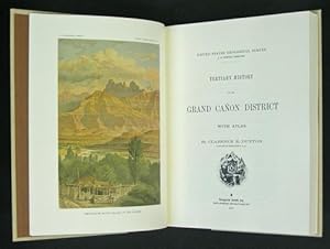
Hardcover. Zustand: Very Good. Washington: Department of the Interior, 1882. Folio (20 x 17 3/4 inches, 505mm x 450mm). Lithographed title page with 10 double-page colour tinted lithographed views of the Grand Canyon, including one after Thomas Moran, based on a sketch by Holmes, and 9 after William H.Holmes plates, 11 double-pa…ge colour printed lithographed maps, and 1 uncoloured map. Bound in original publisher's brown cloth with gilt stamped title to the front board. On the spine, library label 746 to foot. Head and foot of spine worn. Cover worn. Some shading to edges around maps. Rich tones and bright colors. Bookplate of James Strohm Copley, and label of Santa Cruz City Free Library. Library stamps throughout on back of prints.Moran's famous painting"The Grand Cañon of the Yellowstone" (1872) was the first landscape the government hung in the Capitol. It was purchased in June 1872, just three months after Congress voted to establish the Yellowstone area as the country's first national park. By 1873 Moran was in demand as an exploration artist. His work had been widely published, and The Grand Cañon of the Yellowstone had been favorably reviewed in newspapers and journals. Capt. Clarence Dutton (1841-1912 ) focused his early field work on the Colorado Plateau. Out of it came a trilogy of related studies: Report on the Geology of the High Plateaus of Utah (1880), the Tertiary History of the Grand Cañon District (1882), and Mount Taylor and the Zuñi Plateau (1886). His description of this erosion-sculpted terrain enshrined Dutton, along with Powell and G. K. Gilbert, into the founding pantheon of geomorphology and the "American school" of geology.
United States Geological Survey: Atlas to Accompany the Tertiary History of the Grand Canon District
Verlag: Department of the Interior United States Geological Survey., Washington 1882
- Hardcover
- Erstausgabe
Anbieter: Alexandre Antique Prints, Maps & Books, Toronto, ON, KanadaAlexandre Antique Prints, Maps & Books
Verkäufer/-in kontaktierenVerkäufer/-in mit 4 SternenZustand: Gebraucht
EUR 7.161,12
EUR 5,21 VersandVersand von Kanada nach USAAnzahl: 1 verfügbar
Edition : First Edition., Original brown cloth boards backed in black cloth leatherette, rebacked. Upper lettered in gilt. Silver lettering on spine. Beige pasted and free endpapers., Atlas volume only.Lithographed by Julius Bien & Co. (New York). Large Folio (505 x 445 mm). Clarence Edward Dutton (1841 ? 1912) was an American g…eologist and US Army officer who began working as a geologist in 1875 under the direction of John Wesley Powell of the US Geological Survey (USGS) department. Working chiefly in the Colorado Plateau region, Dutton wrote on several subjects, including geological studies of the high plateaus of Utah (1879?80), the earthquake in Charleston of South Carolina in 1886, and the present monograph of the Grand Canyon district (1882), which was the USGS?s first publication (from US Capitol visitor centre website)., Size : Large Folio, A very good example of this definitive work on the Grand Canyon, complete with 23 sheets, including 22 double-page colour-tinted lithograph plates drawn by William H. Holmes and one by Thomas Moran. Including maps, panoramas, and vistas of the Grand Canyon and vicinity, some with two views to a page, some extra-large maps in three or four parts illustrated across as many sheets. This example includes Moran?s highly-sought view of the Kaibab Division Transept (sheet XVIII) and Holmes? triptych panoramic view of the Canyon from Point Sublime (sheets XV, XVI, and XVII), described as a ?masterpiece of American scientific illustration.? Includes plate sheet index with explanatory notes and details. , Blank (2). Title. Blank. List of Atlas Sheets. Blank. 23 plates. Blank (2). Corners bumped, occasional marks to boards, light dampstain to bottom of upper. Interior generally clean and crisp.
Verlag: Washington: Department of the Interior, 1882. 1882
- Hardcover
Anbieter: Arader Galleries - AraderNYC, New York, NY, USAArader Galleries - AraderNYC
Verkäufer/-in kontaktierenVerkäufer/-in mit 5 SternenZustand: Gebraucht - Gut
EUR 6.713,55
Versand nach gratisVersand innerhalb von USAAnzahl: 1 verfügbar
Hardcover. Zustand: Very Good. MORAN, Thomas (1837-1926) - DUTTON, Captain Clarence E. (1841-1912). Atlas to Accompany the Monograph on the Tertiary History of the Grand Canon District. Washington: Department of the Interior, 1882. Folio (20 x 17 4/8 inches). Lithographed title-page, 15 MAGNIFICENT double-page colour tinted lith…ographed views of the Grand Canyon, including one after Thomas Moran, based on a sketch by Holmes, and 9 after William H.Holmes plates, 11 double-page colour printed lithographed maps, and 2 uncoloured maps. Original publisher's brown cloth (shaken, worn and stained, spine strengthened with linen tape). Moran' famous painting"The Grand Cañon of the Yellowstone" (1872) was the first landscape the government hung in the Capitol, was purchased in June 1872, just three months after Congress voted to establish the Yellowstone area as the country's first national park. By 1873 Moran was in demand as an exploration artist. His work had been widely published, and The Grand Cañon of the Yellowstone had been favorably reviewed in newspapers and journals. Dutton's early field work centered on the Colorado Plateau. Out of it came a trilogy of related studies: Report on the Geology of the High Plateaus of Utah (1880), the Tertiary History of the Grand Cañon District (1882), and Mount Taylor and the Zuñi Plateau (1886). His description of this erosion-sculpted terrain enshrined Dutton, along with Powell and G. K. Gilbert, into the founding pantheon of geomorphology and the "American school" of geology. "Most spectacularly, along with Powell, Dutton virtually defined the meaning of the Grand Canyon for American civilization. According to his biographer, Wallace Stegner, "Dutton is almost as much the genius loci of the Grand Canyon as Muir is of Yosemite. And though it is Powell's monument to which the tourists walk after dinner to watch the sunset from the South Rim, it is with Dutton's eyes, as often as not, that they see" ([1953], pp. 173-74)." (Stephen J. Pyne for ANB).
Verlag: Government Printing Office c. 1882, Washington 1882
- Hardcover
- Erstausgabe
Anbieter: Alexandre Antique Prints, Maps & Books, Toronto, ON, KanadaAlexandre Antique Prints, Maps & Books
Verkäufer/-in kontaktierenVerkäufer/-in mit 4 SternenZustand: Gebraucht
EUR 895,14
EUR 5,21 VersandVersand von Kanada nach USAAnzahl: 1 verfügbar
Edition : First Edition, Size : 4vo., Atlas volume only with few double paged maps. It lacks the double page panoramas. One of the boards missing. Title page and maps are separated from the joints with minor losses.
Verlag: WashingtonJulius Bien & Co. Lith. New York . 1882
- Karte
Anbieter: Robert Frew Ltd. ABA ILAB, London, , Vereinigtes KönigreichRobert Frew Ltd. ABA ILAB
Verkäufer/-in kontaktierenVerkäufer/-in mit 5 SternenZustand: Gebraucht
EUR 119,05
EUR 11,56 VersandVersand von Vereinigtes Königreich nach USAAnzahl: 1 verfügbar
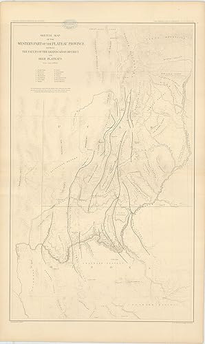
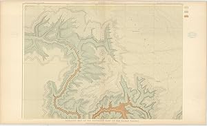
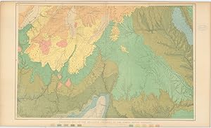
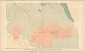
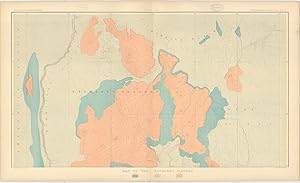
Original double-page lithographed map of a section of the the Grand Canyon (overall dimensions 83.5 x 50.5 cm, map dimensions 73 x 45 cm) from Dutton's Atlas to Accompany the Monograph on the Tertiary History of the Grand Cañon District. Folding down the centre as issued. Ex libris Manchester Geological Society with their librar…y stamp to upper portion. Generally very good. Clarence E. Dutton began working on his Tertiary History of the Grand Canon District while he was a member of the Powell survey. The Atlas beautifully illustrates the Grand Canyon with the use of color lithography by Julius Bien. Tertiary History was important both as a work of art and as the scientific foundation upon which subsequent mapping was based. It is one of the most important cartographic works devoted to the Grand Canyon.

Verlag: WashingtonJulius Bien & Co. Lith. New York . 1882
- Karte
Anbieter: Robert Frew Ltd. ABA ILAB, London, , Vereinigtes KönigreichRobert Frew Ltd. ABA ILAB
Verkäufer/-in kontaktierenVerkäufer/-in mit 5 SternenZustand: Gebraucht
EUR 148,82
EUR 11,56 VersandVersand von Vereinigtes Königreich nach USAAnzahl: 1 verfügbar
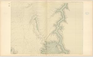
Original double-page chromolithographed map of a section of the the Grand Canyon (overall dimensions 83.5 x 50.5 cm, map dimensions 46 x 71.5 cm) from Dutton's Atlas to Accompany the Monograph on the Tertiary History of the Grand Cañon District. Folding down the centre as issued. Ex libris Manchester Geological Society with two…of their library stamps to margins. Generally very good. Clarence E. Dutton began working on his Tertiary History of the Grand Canon District while he was a member of the Powell survey. The Atlas beautifully illustrates the Grand Canyon with the use of color lithography by Julius Bien. Tertiary History was important both as a work of art and as the scientific foundation upon which subsequent mapping was based. It is one of the most important cartographic works devoted to the Grand Canyon.

Verlag: WashingtonJulius Bien & Co. Lith. New York . 1882
- Karte
Anbieter: Robert Frew Ltd. ABA ILAB, London, , Vereinigtes KönigreichRobert Frew Ltd. ABA ILAB
Verkäufer/-in kontaktierenVerkäufer/-in mit 5 SternenZustand: Gebraucht
EUR 148,82
EUR 11,56 VersandVersand von Vereinigtes Königreich nach USAAnzahl: 1 verfügbar
Original double-page chromolithographed map of a section of the the Grand Canyon (overall dimensions 83.5 x 50.5 cm, map dimensions 46.5 x 65 cm) from Dutton's Atlas to Accompany the Monograph on the Tertiary History of the Grand Cañon District. Folding down the centre as issued. Ex libris Manchester Geological Society with two…of their library stamps to margins. Generally very good. Clarence E. Dutton began working on his Tertiary History of the Grand Canon District while he was a member of the Powell survey. The Atlas beautifully illustrates the Grand Canyon with the use of color lithography by Julius Bien. Tertiary History was important both as a work of art and as the scientific foundation upon which subsequent mapping was based. It is one of the most important cartographic works devoted to the Grand Canyon.
Verlag: WashingtonJulius Bien & Co. Lith. New York . 1882
- Karte
Anbieter: Robert Frew Ltd. ABA ILAB, London, , Vereinigtes KönigreichRobert Frew Ltd. ABA ILAB
Verkäufer/-in kontaktierenVerkäufer/-in mit 5 SternenZustand: Gebraucht
EUR 178,58
EUR 11,56 VersandVersand von Vereinigtes Königreich nach USAAnzahl: 1 verfügbar
Original double-page chromolithographed map of a section of the the Grand Canyon (overall dimensions 83.5 x 50.5 cm, map dimensions 46.5 x 65 cm) from Dutton's Atlas to Accompany the Monograph on the Tertiary History of the Grand Cañon District. Folding down the centre as issued. Ex libris Manchester Geological Society with two…of their library stamps to margins. A few marginal nicks, generally very good. Clarence E. Dutton began working on his Tertiary History of the Grand Canon District while he was a member of the Powell survey. The Atlas beautifully illustrates the Grand Canyon with the use of color lithography by Julius Bien. Tertiary History was important both as a work of art and as the scientific foundation upon which subsequent mapping was based. It is one of the most important cartographic works devoted to the Grand Canyon.

Verlag: WashingtonJulius Bien & Co. Lith. New York . 1882
- Karte
Anbieter: Robert Frew Ltd. ABA ILAB, London, , Vereinigtes KönigreichRobert Frew Ltd. ABA ILAB
Verkäufer/-in kontaktierenVerkäufer/-in mit 5 SternenZustand: Gebraucht
EUR 238,11
EUR 11,56 VersandVersand von Vereinigtes Königreich nach USAAnzahl: 1 verfügbar
Original double-page chromolithographed map of a section of the the Grand Canyon (overall dimensions 83.5 x 50.5 cm, map dimensions 71.5 x 46 cm) from Dutton's Atlas to Accompany the Monograph on the Tertiary History of the Grand Cañon District. Folding down the centre as issued. Ex libris Manchester Geological Society with two…of their library stamps to margins. Generally very good. Clarence E. Dutton began working on his Tertiary History of the Grand Canon District while he was a member of the Powell survey. The Atlas beautifully illustrates the Grand Canyon with the use of color lithography by Julius Bien. Tertiary History was important both as a work of art and as the scientific foundation upon which subsequent mapping was based. It is one of the most important cartographic works devoted to the Grand Canyon.

Verlag: WashingtonJulius Bien & Co. Lith. New York . 1882
- Karte
Anbieter: Robert Frew Ltd. ABA ILAB, London, , Vereinigtes KönigreichRobert Frew Ltd. ABA ILAB
Verkäufer/-in kontaktierenVerkäufer/-in mit 5 SternenZustand: Gebraucht
EUR 238,11
EUR 11,56 VersandVersand von Vereinigtes Königreich nach USAAnzahl: 1 verfügbar
Original double-page chromolithographed map of a section of the the Grand Canyon (overall dimensions 83.5 x 50.5 cm, map dimensions 46.5 x 77.5 cm) from Dutton's Atlas to Accompany the Monograph on the Tertiary History of the Grand Cañon District. Folding down the centre as issued. Ex libris Manchester Geological Society with th…eir library stamp to upper margin. A few marginal nicks, generally very good. Clarence E. Dutton began working on his Tertiary History of the Grand Canon District while he was a member of the Powell survey. The Atlas beautifully illustrates the Grand Canyon with the use of color lithography by Julius Bien. Tertiary History was important both as a work of art and as the scientific foundation upon which subsequent mapping was based. It is one of the most important cartographic works devoted to the Grand Canyon.
Verlag: WashingtonJulius Bien & Co. Lith. New York . 1882
- Karte
Anbieter: Robert Frew Ltd. ABA ILAB, London, , Vereinigtes KönigreichRobert Frew Ltd. ABA ILAB
Verkäufer/-in kontaktierenVerkäufer/-in mit 5 SternenZustand: Gebraucht
EUR 238,11
EUR 11,56 VersandVersand von Vereinigtes Königreich nach USAAnzahl: 1 verfügbar
Original double-page chromolithographed map of a section of the the Grand Canyon (overall dimensions 83.5 x 50.5 cm, map dimensions 71.5 x 46 cm) from Dutton's Atlas to Accompany the Monograph on the Tertiary History of the Grand Cañon District. Folding down the centre as issued. Ex libris Manchester Geological Society with two…of their library stamps to margins. Minor marginal nicks and toning, generally very good. Clarence E. Dutton began working on his Tertiary History of the Grand Canon District while he was a member of the Powell survey. The Atlas beautifully illustrates the Grand Canyon with the use of color lithography by Julius Bien. Tertiary History was important both as a work of art and as the scientific foundation upon which subsequent mapping was based. It is one of the most important cartographic works devoted to the Grand Canyon.
Verlag: WashingtonJulius Bien & Co. Lith. New York . 1882
- Karte
Anbieter: Robert Frew Ltd. ABA ILAB, London, , Vereinigtes KönigreichRobert Frew Ltd. ABA ILAB
Verkäufer/-in kontaktierenVerkäufer/-in mit 5 SternenZustand: Gebraucht
EUR 238,11
EUR 11,56 VersandVersand von Vereinigtes Königreich nach USAAnzahl: 1 verfügbar
Original double-page chromolithographed map of a section of the the Grand Canyon (overall dimensions 83.5 x 50.5 cm, map dimensions 71.5 x 46 cm) from Dutton's Atlas to Accompany the Monograph on the Tertiary History of the Grand Cañon District. Folding down the centre as issued. Ex libris Manchester Geological Society with two…of their library stamps to margins. Generally very good. Clarence E. Dutton began working on his Tertiary History of the Grand Canon District while he was a member of the Powell survey. The Atlas beautifully illustrates the Grand Canyon with the use of color lithography by Julius Bien. Tertiary History was important both as a work of art and as the scientific foundation upon which subsequent mapping was based. It is one of the most important cartographic works devoted to the Grand Canyon.
Verlag: WashingtonJulius Bien & Co. Lith. New York . 1882
- Karte
Anbieter: Robert Frew Ltd. ABA ILAB, London, , Vereinigtes KönigreichRobert Frew Ltd. ABA ILAB
Verkäufer/-in kontaktierenVerkäufer/-in mit 5 SternenZustand: Gebraucht
EUR 238,11
EUR 11,56 VersandVersand von Vereinigtes Königreich nach USAAnzahl: 1 verfügbar
Original double-page chromolithographed map of a section of the the Grand Canyon (overall dimensions 83.5 x 50.5 cm, map dimensions 46.5 x 77.5 cm) from Dutton's Atlas to Accompany the Monograph on the Tertiary History of the Grand Cañon District. Folding down the centre as issued. Ex libris Manchester Geological Society with th…eir library stamp to upper margin. Small marginal nick along bottom of centre-fold, minor smudging, generally very good. Clarence E. Dutton began working on his Tertiary History of the Grand Canon District while he was a member of the Powell survey. The Atlas beautifully illustrates the Grand Canyon with the use of color lithography by Julius Bien. Tertiary History was important both as a work of art and as the scientific foundation upon which subsequent mapping was based. It is one of the most important cartographic works devoted to the Grand Canyon.

Verlag: WashingtonJulius Bien & Co. Lith. New York . 1882
- Kunstdruck
Anbieter: Robert Frew Ltd. ABA ILAB, London, , Vereinigtes KönigreichRobert Frew Ltd. ABA ILAB
Verkäufer/-in kontaktierenVerkäufer/-in mit 5 SternenZustand: Gebraucht
EUR 297,63
EUR 11,56 VersandVersand von Vereinigtes Königreich nach USAAnzahl: 1 verfügbar
Two panoramic tinted lithograph views of Grand Canyon on one sheet (overall dimensions 83.5 x 50.5 cm, print dimensions 19.5 x 74.5 cm each) from Dutton's Atlas to Accompany the Monograph on the Tertiary History of the Grand Cañon District. Folding down the centre as issued. Ex libris Manchester Geological Society with two of th…eir library stamps to upper margin. A few small marginal nicks and tears, generally very good. Clarence E. Dutton began working on his Tertiary History of the Grand Canon District while he was a member of the Powell survey. The Atlas beautifully illustrates the Grand Canyon with the use of color lithography by Julius Bien. The panoramas of the spectacular river gorge are after the paintings of two brilliant topographical artists, W. H. Holmes and Thomas Moran. Tertiary History was important both as a work of art and as the scientific foundation upon which subsequent mapping was based. It is one of the most important cartographic works devoted to the Grand Canyon.


