
Gesamtpreis (1 Artikel Artikel):
Versandziel:

chatelain h (22 Ergebnisse)
Direkt zu den wichtigsten Suchergebnissen
Suchfilter
Produktart
- Alle Product Types
- Bücher (15)
- Magazine & Zeitschriften (Keine weiteren Ergebnisse entsprechen dieser Verfeinerung)
- Comics (Keine weiteren Ergebnisse entsprechen dieser Verfeinerung)
- Noten (Keine weiteren Ergebnisse entsprechen dieser Verfeinerung)
- Kunst, Grafik & Poster (4)
- Fotografien (Keine weiteren Ergebnisse entsprechen dieser Verfeinerung)
- Karten (3)
- Manuskripte & Papierantiquitäten (Keine weiteren Ergebnisse entsprechen dieser Verfeinerung)
Zustand Mehr dazu
Einband
Weitere Eigenschaften
- Erstausgabe (Keine weiteren Ergebnisse entsprechen dieser Verfeinerung)
- Signiert (Keine weiteren Ergebnisse entsprechen dieser Verfeinerung)
- Schutzumschlag (Keine weiteren Ergebnisse entsprechen dieser Verfeinerung)
- Angebotsfoto (12)
Sprache (4)
Gratisversand
Land des Verkäufers
Verkäuferbewertung
-
Carte des etats du Roi de Prusse 1718. (Reprint).
Verlag: Herder, Berlin, 1981
Anbieter: BerlinAntiquariat, Karl-Heinz Than, Berlin, Deutschland
Verkäuferbewertung 5 von 5 Sternen

Bei Großabnahme ist es möglich, Sonderpreise zu vereinbaren. - Die Versandkosten betragen bei mehrfacher Faltung, wie unten angegeben, oder gerollt (zusätzlich) 5,90 . NEUWERTIG !!! Siehe Foto !!!! Schwarz-weiß.
-

PAP. Zustand: New. New Book. Shipped from UK. Established seller since 2000.
-
Kimbundu Grammar
Anbieter: PBShop.store UK, Fairford, GLOS, Vereinigtes Königreich
Verkäuferbewertung 5 von 5 Sternen
EUR 26,70
EUR 4,81 Versand
Versand von Vereinigtes Königreich nach USAAnzahl: 15 verfügbar
In den WarenkorbPAP. Zustand: New. New Book. Shipped from UK. Established seller since 2000.
-

Three Science Fiction Novellas: From Prehistory to the End of Mankind
Anbieter: Revaluation Books, Exeter, Vereinigtes Königreich
Verkäuferbewertung 5 von 5 Sternen
EUR 29,31
EUR 11,56 Versand
Versand von Vereinigtes Königreich nach USAAnzahl: 1 verfügbar
In den WarenkorbPaperback. Zustand: Brand New. 240 pages. 8.75x5.75x0.75 inches. In Stock.
-
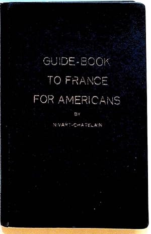
Guide-Book to France for Americans (Fourth Edition)
Verlag: A. Benard, Belgium, 1923
Anbieter: The Kelmscott Bookshop, ABAA, Savage, MD, USA
Verbandsmitglied: ABAA ESA ILAB IOBA MBS
Verkäuferbewertung 5 von 5 Sternen
Hardcover. Zustand: Very Good -. Hardcover. Very good- in blue boards cloth covered flexible boards with faded gilt title to front board and to spine. Split to binding and crack to rear interior hinge. Illustrations throughout. 286 pages. French Travel. TRA81142.
-

HRD. Zustand: New. New Book. Shipped from UK. Established seller since 2000.
-

Le Mistčre de Saint Quentin, suivi des Invencions du corps de Saint Quentin (Litterature) (French Edition)
Anbieter: Ria Christie Collections, Uxbridge, Vereinigtes Königreich
Verkäuferbewertung 5 von 5 Sternen
EUR 38,56
EUR 13,85 Versand
Versand von Vereinigtes Königreich nach USAAnzahl: Mehr als 20 verfügbar
In den WarenkorbZustand: New. In.
-

Three Science Fiction Novellas: From Prehistory to the End of Mankind
Anbieter: Revaluation Books, Exeter, Vereinigtes Königreich
Verkäuferbewertung 5 von 5 Sternen
EUR 57,04
EUR 14,45 Versand
Versand von Vereinigtes Königreich nach USAAnzahl: 2 verfügbar
In den WarenkorbHardcover. Zustand: Brand New. 240 pages. 9.06x6.38x0.94 inches. In Stock.
-
Kimbundu Grammar
Anbieter: PBShop.store UK, Fairford, GLOS, Vereinigtes Königreich
Verkäuferbewertung 5 von 5 Sternen
EUR 35,04
EUR 5,80 Versand
Versand von Vereinigtes Königreich nach USAAnzahl: 15 verfügbar
In den WarenkorbHRD. Zustand: New. New Book. Shipped from UK. Established seller since 2000.
-
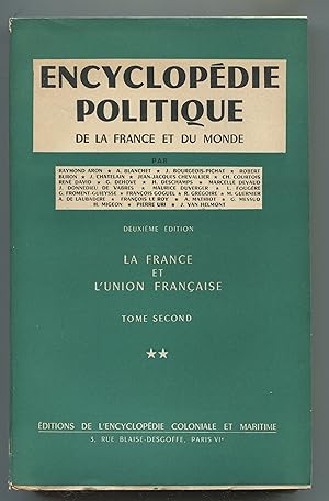
Encyclopédie politique de la France et du monde - La France et l'union française Tome second **
Verlag: Editions de l'Encyclopédie coloniale et maritime sd, Paris
Anbieter: LibrairieLaLettre2, Villefranche de Lauragais, Frankreich
Verkäuferbewertung 5 von 5 Sternen
Broché. Zustand: Bon état. in-8 Description :399 pp. Exemplaire en partie non coupé. Couverture légčrement salie. Langue : Français Nb de volumes : 1.
-

Le Mistčre de Saint Quentin, suivi des Invencions du corps de Saint Quentin
Sprache: Französisch
Verlag: Hachette Livre Feb 2018, 2018
ISBN 10: 2013745826 ISBN 13: 9782013745826
Anbieter: AHA-BUCH GmbH, Einbeck, Deutschland
Verkäuferbewertung 5 von 5 Sternen
Taschenbuch. Zustand: Neu. Neuware - WORK IS IN FRENCH.
-
Catalogue général illustré (4e édition)
Erscheinungsdatum: 1925
Anbieter: Librairie Alain Brieux, Paris, Frankreich
Verbandsmitglied: ILAB
Verkäuferbewertung 4 von 5 Sternen

Couverture rigide. Zustand: Bon. 14 pp. Paris, H. Chatelain, F. Baudet, 1925, in-8, 14 pp, Broché, couverture illustrée en noir, Catalogue illustré en noir d'instruments de précision: "podomčtres - curvimčtres - métreurs automatiques - cercles ŕ calcul - compteurs enregistreurs - compteurs de tours - compteurs de temps". Échelles métriques en derničre page. Exemplaire légčrement défraichi.
-

Chartularium Universitatis Parisiensis: Sub Auspices Consilii Generalis Facultatum Parisiensium: Ab Anno MCCLXXXVI Usque ad Annum MCCCL (Volume 2.1)
Verlag: Fratrum Delalain, 1891
Anbieter: Anybook.com, Lincoln, Vereinigtes Königreich
Verkäuferbewertung 5 von 5 Sternen
EUR 297,76
EUR 54,33 Versand
Versand von Vereinigtes Königreich nach USAAnzahl: 1 verfügbar
In den WarenkorbZustand: Good. Volume 2.1. This is an ex-library book and may have the usual library/used-book markings inside.This book has hardback covers. In good all round condition. Large red cloth folio with red leather half binding. Raised bands, gilt lettering, and gilt motif on backstrip. Bumped corners and some general wear. Original brown paper soft covers secured inside. Red and black lettering and black decorative border on front cover. Interior is secure, clean and clear save for some light foxing. Red speckled trimmed edges. Please note the Image in this listing is a stock photo and may not match the covers of the actual item,4600grams, ISBN:
-
Chartularium Universitatis Parisiensis sub Auspiciis Consilii Generalis Facultatum Parisiensium (Volume 1-2)
Verlag: Fratrum Delalain, 1889
Anbieter: Anybook.com, Lincoln, Vereinigtes Königreich
Verkäuferbewertung 5 von 5 Sternen
EUR 476,42
EUR 66,35 Versand
Versand von Vereinigtes Königreich nach USAAnzahl: 1 verfügbar
In den WarenkorbZustand: Fair. Volume 1-2. This is an ex-library book and may have the usual library/used-book markings inside.This book has hardback covers. In fair condition, suitable as a study copy. Re-bound by library. Large 8vo with brown marbled boards and brown cloth quarter binding. Gilt lettering on sun faded backstrip. Chipping to backstrip ends. Vol I. has several small tears in backstrip. Vol II. has fraying ad tearing and one joint is split, secured with clear tape. Bumped corners and some general wear. Hinges split in vol II. Interior is secure, clean and clear. Trimmed. Please note the Image in this listing is a stock photo and may not match the covers of the actual item,7700grams, ISBN:
-
Critique de l'économie politique. [1. L'inflation - 2. La crise du systčme monétaire international - 3. La formation du sous-développement - 4-5. Sur l'impérialisme - 6. La construction du socialisme - 7-8. La nature des pays de l'Est - 9. Sur la méthode - 10. Travail et emploi - 11-12. Crises / Travail / Chili - 13-14. L'impérialisme.
Verlag: Critique de l'économie politique, du n° 1 au n° 14, septembre 1970 - décembre 1973. 14 numéros en 10 volumes in-8°, brochés., 1973
Anbieter: Librairie Dhouailly, Paris, Frankreich
Verbandsmitglied: ILAB
Verkäuferbewertung 4 von 5 Sternen
Collection complčte. TBE. [17169].
-
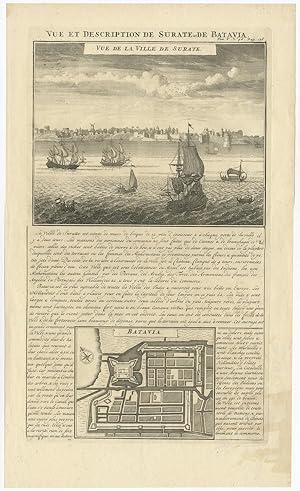
Antique Print of Surate (India) and Batavia (Indonesia) by H. Chatelain (1719)
Verlag: H. Chatelain, 1719
Anbieter: Bartele Gallery - The Netherlands, Langweer, FRL, Niederlande
Verkäuferbewertung 5 von 5 Sternen
Kunst / Grafik / Poster
No Binding. Zustand: Very Good. Antique print titled 'Vue et Description de Surate et de Batavia'. Attractive view of the town and harbor of Surate on the northwest coast of India, and a bird's-eye city plan of Batavia (Jakarta) present-day capital of Indonesia, from Chatelain's monumental 7 volume Atlas Historique, published in Amsterdam. Surate was the first English trading post in India and was known as a gold and textile center. Batavia was the capital of the Dutch East Indian trading empire during the period when the Dutch dominated trade from the famous Spice Islands. Good condition, some staining in bottom right corner. Please study image carefully. Overall size: 43.5 x 26 cm. Image size: 38 x 21 cm.
-

Antique Map of Asia by H. Chatelain (1719)
Verlag: H. Chatelain, 1719
Anbieter: Bartele Gallery - The Netherlands, Langweer, FRL, Niederlande
Verkäuferbewertung 5 von 5 Sternen
Karte
No Binding. Zustand: Good. Antique map titled 'Carte de L'Asie selon le auteurs Anciens enrichie de Remarques Historiques sur les changemens qui y sont arrivez (.)'. Detailed map of Asia, extending from the Mediterranean, the Red Sea and the Saudi Arabian Peninsula to Japan, the Philippines and Southeast Asia. The map is centered on the India and the Indian Ocean, with explanatory text on either side of the map. The map appeared in Chatelain's monumental 7 volume Atlas Historique. General age-related toning, some foxing. Please study image carefully. Overall size: 57 x 48 cm. Image size: 48 x 37.5 cm.
-
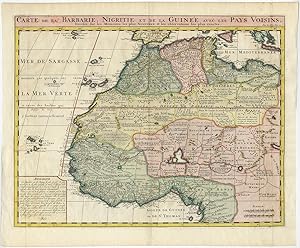
Antique Map of Northwestern Africa by H. Chatelain (1719)
Verlag: H. Chatelain, 1719
Anbieter: Bartele Gallery - The Netherlands, Langweer, FRL, Niederlande
Verkäuferbewertung 5 von 5 Sternen
Karte
No Binding. Zustand: Very Good. Antique map titled 'Carte de la Barbarie, Nigritie et de la Guinee avec les Pays Voisins'. Chatelain based this map of the northwestern Africa on De L'Isle's map of the same area. The map is a good strong impression on heavy paper. Southern Spain, Sicily and parts of Greece are depicted at the far north of the map. African Kingdoms of the early eighteenth centrury are portrayed from Morocco in the northwest, to the eastern edge of Tripoly and southward and around the western edge of Africa to the Kingdom of Benin. Countless small kingdoms are noted throughout the area, as are major rivers, lakes and mountain ranges. The Sahara Desert, with the Tropic of Cancer running through its center is depicted and the myriad indigenous peoples of the area are named. The lower left quadrant contains a description of Guinea, Nigeria, and the Barbary Coast. The map is remarkably accurate and this version was used for decades by cartographers and publishing houses. General age-related toning, please study image carefully. Overall size: 55.5 x 46 cm. Image size: 50.5 x 40 cm.
-
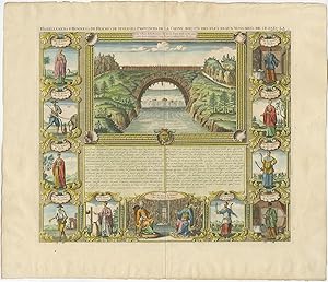
Antique Print of a Bridge in Xensi (China) by H. Chatelain (1719)
Verlag: H. Chatelain, 1719
Anbieter: Bartele Gallery - The Netherlands, Langweer, FRL, Niederlande
Verkäuferbewertung 5 von 5 Sternen
Kunst / Grafik / Poster
No Binding. Zustand: Very Good. Antique print titled 'Habillemens d'Hommes & de Femmes de Diverses Provinces de la Chine Avec Un Des Plus Beaux Monumens De Ce Pais-La'. An interesting folio sheet featuring a view of a bridge in Xensi Province enclosed in a very decorative picture-frame style border. The view is surrounded with eleven vignettes showing the people of the various provinces of China. A finely engraved chart from Chatelain's moumental 7 volume Atlas Historique, on of the most famous and prolific works of the early 18th century. Good condition, please study image carefully. Overall size: 48 x 36 cm. Image size: 43 x 37 cm.
-
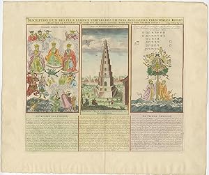
Antique Print showing Chinese Temples and Idols by H. Chatelain (1719)
Verlag: H. Chatelain, 1719
Anbieter: Bartele Gallery - The Netherlands, Langweer, FRL, Niederlande
Verkäuferbewertung 5 von 5 Sternen
Kunst / Grafik / Poster
No Binding. Zustand: Very Good. Antique map titled 'Description d'un des plus fameux temples des Chinois (.)'. An early 18th century French print in modern hand-colour showing one of China's most famous temples, also a nine-storey pyramidal tower in Fokkien Province and the main Chinese idols including a Chinese pagan goddess by Henri Abraham Châtelain (1684-1743) and published in his Atlas Historique, ou Nouvelle Introduction ŕ l'Histoire, a la Chronologie & Moderne between 1705 and 1720 and thereafter in 1721 and between 1732 and 1739. Good condition, please study image carefully. Overall size: 57 x 48cm. Image size: 43.5 x 36.5 cm.
-
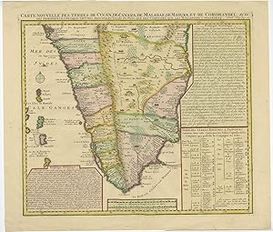
Antique Map of Southern India by H. Chatelain (1719)
Verlag: H. Chatelain, 1719
Anbieter: Bartele Gallery - The Netherlands, Langweer, FRL, Niederlande
Verkäuferbewertung 5 von 5 Sternen
Karte
No Binding. Zustand: Very Good. Antique map titled 'Carte Nouvelle des Terres de Cucan, de Canara, de Malabar, de Madura, et de Coromandel (.)'. This is an authentic antique map of the southern portion of India by Henri Chatelain. The map was published out of Amsterdam circa 1719 as part of Chatelain's seven volume "Atlas Historique." This map shows from Goa and Nelour to the southern tip of India in exceptional detail. The Western Ghats mountain range runs the length of the coast while hills, forests and indigenous animals are engraved throughout. Cities, villages, ports, and bays are noted along the coast while the interior includes focuses on larger cities and regional divisions. Two text boxes present the history of the area and a table presents a breakdown of the various kingdoms, capitals, and cities within each province. Minor age-related toning, small tear along center fold. Please study image carefully. Overall size: 49.5 x 43 cm. Image size: 43 x 37.5 cm.
-

Antique Print of the Ruling Families of Europe (1732)
Erscheinungsdatum: 1732
Anbieter: Bartele Gallery - The Netherlands, Langweer, FRL, Niederlande
Verkäuferbewertung 5 von 5 Sternen
Kunst / Grafik / Poster
No Binding. Zustand: Very Good. Antique print titled 'Genealogie de la Maison de Wirtemberg (.)'. Old print of the genealogy of the ruling families of Europe who were allied with Holland at the beginning of the eighteenth century. This print orginates from 'Atlas Historique'. Very good condition, please study image carefully. Overall size: 51.1 x 43.3 cm. Image size: 43.4 x 33.1 cm. The collection of Bartele Gallery includes over 50,000 authentic antique maps, sea charts, prints and books. Our Abebooks store includes a selection of maps, prints and books for SALE prices. Please visit our other online sales channels to explore our complete collection of original antique maps and prints!


