Gesamtpreis (1 Artikel Artikel):
Versandziel:

cellarius christopher (16 Ergebnisse)
Direkt zu den wichtigsten Suchergebnissen
Suchfilter
Produktart
- Alle Product Types
- Bücher (15)
- Magazine & Zeitschriften (Keine weiteren Ergebnisse entsprechen dieser Verfeinerung)
- Comics (Keine weiteren Ergebnisse entsprechen dieser Verfeinerung)
- Noten (Keine weiteren Ergebnisse entsprechen dieser Verfeinerung)
- Kunst, Grafik & Poster (Keine weiteren Ergebnisse entsprechen dieser Verfeinerung)
- Fotografien (Keine weiteren Ergebnisse entsprechen dieser Verfeinerung)
- Karten (1)
- Manuskripte & Papierantiquitäten (Keine weiteren Ergebnisse entsprechen dieser Verfeinerung)
Zustand Mehr dazu
- Neu (Keine weiteren Ergebnisse entsprechen dieser Verfeinerung)
- Wie Neu, Sehr Gut oder Gut Bis Sehr Gut (Keine weiteren Ergebnisse entsprechen dieser Verfeinerung)
- Gut oder Befriedigend (2)
- Ausreichend oder Schlecht (Keine weiteren Ergebnisse entsprechen dieser Verfeinerung)
- Wie beschrieben (14)
Einband
- alle Einbände
- Hardcover (3)
- Softcover (Keine weiteren Ergebnisse entsprechen dieser Verfeinerung)
Weitere Eigenschaften
- Erstausgabe (1)
- Signiert (Keine weiteren Ergebnisse entsprechen dieser Verfeinerung)
- Schutzumschlag (Keine weiteren Ergebnisse entsprechen dieser Verfeinerung)
- Angebotsfoto (16)
Sprache (2)
Preis
- Beliebiger Preis
- Weniger als EUR 20 (Keine weiteren Ergebnisse entsprechen dieser Verfeinerung)
- EUR 20 bis EUR 45 (Keine weiteren Ergebnisse entsprechen dieser Verfeinerung)
- Mehr als EUR 45
Gratisversand
- Kostenloser Versand nach USA (Keine weiteren Ergebnisse entsprechen dieser Verfeinerung)
Land des Verkäufers
Verkäuferbewertung
-
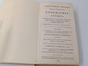
Geographia Antiqua. Recognita denuo, & ad veterum novorumque scriptorum fidem, historicorum maxime, identidem castigata.
Sprache: Deutsch
Verlag: F.C. & J. Rivington London, 1816
Anbieter: Antiquariat Kelifer, Flensburg, Deutschland
Verbandsmitglied: GIAQ
Verkäuferbewertung 5 von 5 Sternen

Zustand: Gut. Editio nova et castigatior. 180 S. Mit einigen s/w-Karten bzw. Illustrationen, zum größten Teil ausklappbar. Die Karten Nummer 2, 3, 5, 6 und 7 (von 27) scheinen nach der Nummerierung zu fehlen. Neu in Pappband gebunden. Einband leicht berieben und leicht lichtrandig. Kanten leicht bestoßen. Schnitt nachgedunkelt. Karten in gutem Zustand. Sprache: Deutsch Gewicht in Gramm: 384 Pappband (nachgebunden, ca. 1970er / 1980er Jahre) 21,6cm x 13,6cm.
-
Notitia Orbis Antiqvi, Sive, Geographia Plenior: Ab Ortu Rerumpublicarum Ad Constantinorum Tempora Orbis Terrarum Faciem Declarans (The Knowledge of the Ancient World, or a Complete Geography, From the Rise of the Republic to the Times of Constantine, Declaring the Face of the World) 2 Vols
Verlag: Printed by Gleditsch, Senior, Leipzig, 1706
Anbieter: ERIC CHAIM KLINE, BOOKSELLER (ABAA ILAB), Santa Monica, CA, USA
Verkäuferbewertung 4 von 5 Sternen

Erstausgabe
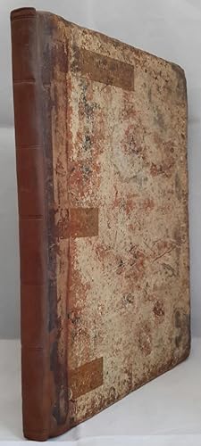
Hardcover. Zustand: Very good condition. First edition. Quarto. [16] 1332 [64]; [16] 889, [1] 254 [62]pp. Original polished vellum over boards. Speckled edges. Frontispiece engraving of author by Martin Bernigeroth. Engraved title page vignettes. Two engraved headpieces. Decorative initials and endpieces. First edition of descriptive atlas of Europe, Asia, the Middle East and Northern Africa. With 21 folding maps in volume one, 13 folding maps in volume two. Christoph Cellarius' (1638-1707) atlas of ancient geography is considered his most important work. (Sandys I, p. 369, Graesse II p. 99.) Collected from ancient and proven monuments, illustrated with new geographical tables, drawn with great care and study. A very copious index of places and other geographical matters has been added. Binding with light wear along edges and lightly rubbed; some staining in lower front cover near spine of volume two. Exlibris with coat of arms of George W. Burckhard on inside front covers, with inked notes dated 1808. Slightly starting at inside front covers.
-
Geographia Antiqua: Being a Complete Set of Maps of Ancient Geography; Beautifully Engraved from Cellarius. On Thirty-Three Copper-Plates. Designed for the Use of Schools, and of Gentlemen Who Make the Ancient Writers Their Delight or Study.
Verlag: F. C. and J. Rivington. London, 1821
Anbieter: Addyman Books, Hay-on-Wye, Vereinigtes Königreich
Verkäuferbewertung 5 von 5 Sternen
Karte
EUR 596,23
EUR 27,79 Versand
Versand von Vereinigtes Königreich nach USAAnzahl: 1 verfügbar
In den WarenkorbA New Edition. Printed with a lovely clear double page title, contents page also a double page spread and 33 double page maps, sculpted by R. W. Seale. Original marbled boards, rubbed but sound, rebacked in modern plain brown calf, old tape marks to boards and endpapers. A lovely flowing ownership signature, dated 1822 with a very sweet pencil drawing of two pigs also to front free endpaper and some very professional owls to rear endpapers. A few portions of foxing to prelims and margins but the maps are clean. A lovely early 19th century atlas.
-
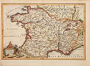
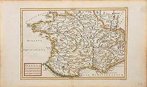
Gallia Narbonensis, Lugdunensis et Aquitania.
Verlag: Dublin: Geographia Antiqua, [c.1794], 1794
Anbieter: Peter Harrington. ABA/ ILAB., London, Vereinigtes Königreich
Verbandsmitglied: ABA ILAB PBFA
Verkäuferbewertung 5 von 5 Sternen
EUR 83,47
EUR 25,47 Versand
Versand von Vereinigtes Königreich nach USAAnzahl: 1 verfügbar
In den WarenkorbAn attractive map of Roman France, with a decorative cartouche representing a Roman General handling a crown to a female figure, perhaps Gallia, and a cock representing Gallic pride. Copper engraving. Hand coloured. Sheet size: 245 x 332 mm Plate size: 210 x 310 mm Very good condition.
-
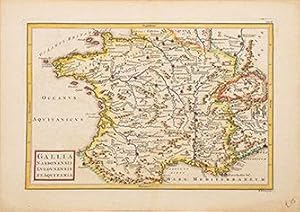
Gallia Narbonensis, Lugdunensis et Aquitania.
Verlag: Dublin: Geographia Antiqua, [c.1794], 1794
Anbieter: Peter Harrington. ABA/ ILAB., London, Vereinigtes Königreich
Verbandsmitglied: ABA ILAB PBFA
Verkäuferbewertung 5 von 5 Sternen
EUR 89,43
EUR 25,47 Versand
Versand von Vereinigtes Königreich nach USAAnzahl: 1 verfügbar
In den WarenkorbAn attractive 18th century map of Roman France: Gaul, Narbonne, Lyon and Aquitaine. Copper engraving. Hand coloured. Sheet size: 262 x 370 mm Plate size: 215 x 315 mm Very good condition.
-
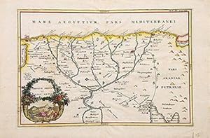
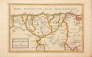
Aegypti Delta et Nili Ostia.
Verlag: Dublin: Geographia Antiqua, 1794, 1794
Anbieter: Peter Harrington. ABA/ ILAB., London, Vereinigtes Königreich
Verbandsmitglied: ABA ILAB PBFA
Verkäuferbewertung 5 von 5 Sternen
EUR 89,43
EUR 25,47 Versand
Versand von Vereinigtes Königreich nach USAAnzahl: 1 verfügbar
In den WarenkorbAn attractive map of the mouth and estuary of the Nile in Egypt, together with a cartouche of a double cornucopia showing the anthropomorphic figure of the River Nile and the Sphinx of Giza. Copper engraving. Hand coloured. Sheet size: 232 x 356 mm Plate size: 206 x 312 mm Very good condition.
-
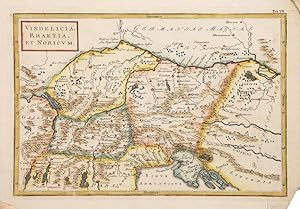
Vindelicia, Rhaetia et Noricum.
Verlag: Dublin: Geographia Antiqua, [c.1794], 1794
Anbieter: Peter Harrington. ABA/ ILAB., London, Vereinigtes Königreich
Verbandsmitglied: ABA ILAB PBFA
Verkäuferbewertung 5 von 5 Sternen
EUR 101,36
EUR 25,47 Versand
Versand von Vereinigtes Königreich nach USAAnzahl: 1 verfügbar
In den WarenkorbAn attractive map of the ancient Roman provinces North of Italy and current Austria and Slovenia. Copper engraving. Hand coloured. Size: 235 x 344 mm Very good condition.
-
Gallia Narbonensis, Lugdunensis et Aquitania.
Verlag: Dublin: Geographia Antiqua, 1794, 1794
Anbieter: Peter Harrington. ABA/ ILAB., London, Vereinigtes Königreich
Verbandsmitglied: ABA ILAB PBFA
Verkäuferbewertung 5 von 5 Sternen
EUR 101,36
EUR 25,47 Versand
Versand von Vereinigtes Königreich nach USAAnzahl: 1 verfügbar
In den WarenkorbAn attractive map of Roman France. Copper engraving. Hand coloured. Sheet size: 232 x 372 mm Plate size: 216 x 315 mm Very good condition.
-
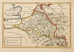
Gallia Belgica.
Verlag: Dublin: Geographia Antiqua, [c.1794], 1794
Anbieter: Peter Harrington. ABA/ ILAB., London, Vereinigtes Königreich
Verbandsmitglied: ABA ILAB PBFA
Verkäuferbewertung 5 von 5 Sternen
EUR 113,28
EUR 25,47 Versand
Versand von Vereinigtes Königreich nach USAAnzahl: 1 verfügbar
In den WarenkorbA map of ancient Roman Belgium. Copper engraving. Hand coloured. Size: 235 x 326 mm Very good condition.
-
Aegypti Delta et Nili Ostia.
Verlag: Dublin: Geographia Antiqua, 1794, 1794
Anbieter: Peter Harrington. ABA/ ILAB., London, Vereinigtes Königreich
Verbandsmitglied: ABA ILAB PBFA
Verkäuferbewertung 5 von 5 Sternen
EUR 113,28
EUR 25,47 Versand
Versand von Vereinigtes Königreich nach USAAnzahl: 1 verfügbar
In den WarenkorbAn attractive map of the Delta of River Nile and the Northern part of Egypt. Copper engraving. Hand coloured. Sheet size: 234 x 375 mm Plate size: 208 x 315 mm Very good condition.
-
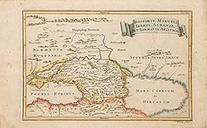
Bosporus, Maeotis, Iberia, Albania et Sarmatia Asiatica.
Verlag: Geographia Antiqua, 1794, 1794
Anbieter: Peter Harrington. ABA/ ILAB., London, Vereinigtes Königreich
Verbandsmitglied: ABA ILAB PBFA
Verkäuferbewertung 5 von 5 Sternen
EUR 113,28
EUR 25,47 Versand
Versand von Vereinigtes Königreich nach USAAnzahl: 1 verfügbar
In den WarenkorbAn attractive map of the Caucasus with the Black and Caspian seas. Copper engraving. Hand coloured. Size: 232 x 374 mm Very good condition.
-
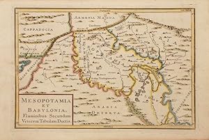
Mesopotamia et Babylonia, Fluminibus Secundum Veterem Tabulam Ductis.
Verlag: Geographia Antiqua, 1794, 1794
Anbieter: Peter Harrington. ABA/ ILAB., London, Vereinigtes Königreich
Verbandsmitglied: ABA ILAB PBFA
Verkäuferbewertung 5 von 5 Sternen
EUR 143,10
EUR 25,47 Versand
Versand von Vereinigtes Königreich nach USAAnzahl: 1 verfügbar
In den WarenkorbCopper engraving. Hand coloured. Size: 233 x 350 mm Very good condition.
-
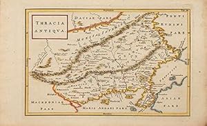
Thracia Antiqua.
Verlag: Dublin: Geographia Antiqua, [c.1794], 1794
Anbieter: Peter Harrington. ABA/ ILAB., London, Vereinigtes Königreich
Verbandsmitglied: ABA ILAB PBFA
Verkäuferbewertung 5 von 5 Sternen
EUR 143,10
EUR 25,47 Versand
Versand von Vereinigtes Königreich nach USAAnzahl: 1 verfügbar
In den WarenkorbAn attractive map of Ancient Thracia. Copper engraving. Hand coloured. Sheet size: 234 x 372 mm Plate size: 218 x 312 mm Very good condition.
-
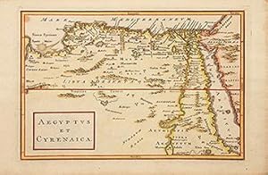
Aegyptus et Cyrenaica.
Verlag: Dublin: Geographia Antiqua, 1794, 1794
Anbieter: Peter Harrington. ABA/ ILAB., London, Vereinigtes Königreich
Verbandsmitglied: ABA ILAB PBFA
Verkäuferbewertung 5 von 5 Sternen
EUR 143,10
EUR 25,47 Versand
Versand von Vereinigtes Königreich nach USAAnzahl: 1 verfügbar
In den WarenkorbAn attractive map of Egypt and the Cyrenaic Peninsula and Egypt. Copper engraving. Hand coloured. Sheet size: 232 x 356 mm Plate size: 206 x 312 mm Very good condition.
-
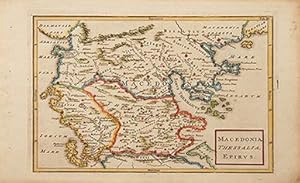
Macedonia, Thessalia, Epirus.
Verlag: Dublin: Geographia Antiqua, [c.1794], 1794
Anbieter: Peter Harrington. ABA/ ILAB., London, Vereinigtes Königreich
Verbandsmitglied: ABA ILAB PBFA
Verkäuferbewertung 5 von 5 Sternen
EUR 196,76
EUR 25,47 Versand
Versand von Vereinigtes Königreich nach USAAnzahl: 1 verfügbar
In den WarenkorbAn attractive map of the Ancient Northern part of Greece. Copper engraving. Hand coloured. Size: 235 x 375 mm Very good condition.
-

Historia universalis breviter ac perspicue exposita. Editio VIII. 3 Teile in einem Band
Anbieter: Antiquariat Librissimo, Eicklingen, Deutschland
Verkäuferbewertung 5 von 5 Sternen
Felix Bielcke, Jena, 1730. 8 Bl., 242 S., 3, 2 Bl., 275 S., 3, 4 Bl., 550 (statt 575) Seiten mit Holzschnitt-Druckermarke. Pergament der Zeit (Einband fleckig/ Kapital mit kleinem Ausbruch/ es fehlt S. 1-2 des ersten Teils/ S. 223 mit großem Ausriss und Textverlust)---- Enthält auch: Teil 2: Historia media aevi temporibus constantini magni ad constantinopolim a turcis captam deducta/ Teil 3: Historia nova hoc est XVI et XVII saeculorum cum initio seculi XVIII. NDB 3, S. 180; vgl. VD18 14149680 (Ausgabe 1732). -.