C b colton (18 Ergebnisse)

- Softcover
Anbieter: PBShop.store US, Wood Dale, IL, USAPBShop.store US
Verkäufer/-in kontaktierenVerkäufer/-in mit 5 SternenZustand: Neu
EUR 26,03
Versand nach gratisVersand innerhalb von USAAnzahl: 15 verfügbar
PAP. Zustand: New. New Book. Shipped from UK. Established seller since 2000.
- Softcover
Anbieter: PBShop.store UK, Fairford, GLOS, Vereinigtes KönigreichPBShop.store UK
Verkäufer/-in kontaktierenVerkäufer/-in mit 5 SternenZustand: Neu
EUR 25,16
EUR 3,81 VersandVersand von Vereinigtes Königreich nach USAAnzahl: 15 verfügbar
PAP. Zustand: New. New Book. Shipped from UK. Established seller since 2000.

- Hardcover
Anbieter: PBShop.store US, Wood Dale, IL, USAPBShop.store US
Verkäufer/-in kontaktierenVerkäufer/-in mit 5 SternenZustand: Neu
EUR 35,49
Versand nach gratisVersand innerhalb von USAAnzahl: 15 verfügbar
HRD. Zustand: New. New Book. Shipped from UK. Established seller since 2000.

Book Collecting and Scholarship
Blegen, Theodore C.; James Ford Bell, Stanley Pargellis, Colton Storm & Louis B.
Verlag: University of Minnesota Pres
Anbieter: Wonder Book, Frederick, MD, USAWonder Book
Verkäufer/-in kontaktierenVerkäufer/-in mit 5 SternenZustand: Gebraucht - Gut
EUR 17,74
Versand nach gratisVersand innerhalb von USAAnzahl: 1 verfügbar
Zustand: Very Good. Very Good condition. No Dust Jacket (book collecting ) A copy that may have a few cosmetic defects. May also contain light spine creasing or a few markings such as an owner's name, short gifter's inscription or light stamp.
- Hardcover
Anbieter: PBShop.store UK, Fairford, GLOS, Vereinigtes KönigreichPBShop.store UK
Verkäufer/-in kontaktierenVerkäufer/-in mit 5 SternenZustand: Neu
EUR 33,52
EUR 4,81 VersandVersand von Vereinigtes Königreich nach USAAnzahl: 15 verfügbar
HRD. Zustand: New. New Book. Shipped from UK. Established seller since 2000.
Book Collecting and Scholarship.
Blegen, Theodore C.; Bell, James Ford; Pargellis, Stanley; Storm, Colton; Wright, Louis B.
Verlag: Minneapolis: University of Minnesota Press. 1954
- Hardcover
Anbieter: Wittenborn Art Books, San Francisco, CA, USAWittenborn Art Books
Verkäufer/-in kontaktierenVerkäufer/-in mit 5 SternenZustand: Gebraucht - Befriedigend
EUR 44,43
EUR 8,63 VersandVersand innerhalb von USAAnzahl: 1 verfügbar
Zustand: Good. 12mo. 67 pp. Black and red cloth-covered boards with gilt spine and gilt lettering on front board. Very good with light sunning. In brodart jacket with red laid endpapers. Red illustrated capitals. Copy number 46 of a special edition of 750 copies. From the collection of the late Frederick Ruffner, Jr., founder of… Gale Research, Detroit.
Verlag: G.W. & C.B. Colton: NY 1868
- Softcover
Anbieter: John K King Used & Rare Books, Detroit, MI, USAJohn K King Used & Rare Books
Verkäufer/-in kontaktierenVerkäufer/-in mit 5 SternenZustand: Gebraucht - Befriedigend
EUR 153,28
EUR 4,74 VersandVersand innerhalb von USAAnzahl: 1 verfügbar
Paperback. Zustand: Good. 34 x 25", colored map, folds, edges chipped, creased and unevenly cut, toning at folds, horizontal center fold torn halfway through from left edge, but still an interesting map showing the Mississippi Valley from Minnesota down to southern Missouri. SWAF. Not a reprint.
 Weitere Bilder
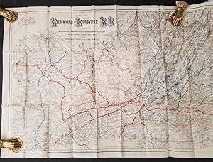
Map of the Richmond and Louisville Railroad, Connecting the Railroads of Virginia with the Railroads of Kentucky on the Shortest Route East and West from the Mississippi Valley to the Atlantic Ocean
Colton, G.W. & C. B. & Co
Verlag: Colton & Co, N.Y. 1882
- Softcover
- Erstausgabe
- Karte
Anbieter: Recycled, Corte Madera, CA, USARecycled
Verkäufer/-in kontaktierenVerkäufer/-in mit 5 SternenZustand: Gebraucht - Gut
EUR 155,50
EUR 6,04 VersandVersand innerhalb von USAAnzahl: 1 verfügbar
Soft cover. Zustand: Very Good. 1st Edition. Lithographed map, folded into stiff tan card wrappers with the title on the cover, which is tanned and chipped. The map itself is 48 x 25.5 inches, but the wrappers only 5 by 10 inches, so there are fold lines, a few tears at those lines, and minor edge chipping to the map. Illustrate…d (illustrator).
Verlag: G.W. & C.B. Colton & Co.
- Hardcover
Anbieter: Wonder Book, Frederick, MD, USAWonder Book
Verkäufer/-in kontaktierenVerkäufer/-in mit 5 SternenZustand: Gebraucht - Befriedigend
EUR 167,12
Versand nach gratisVersand innerhalb von USAAnzahl: 1 verfügbar
Zustand: Good. New York: G.W. & C.B. Colton, 1865. 24mo decoratively embossed cloth hardcover with gilt lettering to the front. Pubisher information on front pastedown. 29 x 56 cm Fold-out map of Kentucky with portions of adjoining states represented. State borders outlined in pink, counties shaded differing colors, with relief…shown by hachures. Good condition. Near Fine cover is in remarkable condition. Front endpaper shows a small brown fleck. Brown ink "x"s marked though the center of the map, else Very Good to Near Fine. (Kentucky, Map) Inquire if you need further information.

Verlag: New York. Published by G.W. & C.B. Colton. 1880 1880
- Hardcover
- Karte
Anbieter: J. Patrick McGahern Books Inc. (ABAC), Ottawa, ON, KanadaJ. Patrick McGahern Books Inc. (ABAC)
Verkäufer/-in kontaktierenVerkäufer/-in mit 4 SternenZustand: Gebraucht
EUR 158,75
EUR 8,63 VersandVersand von Kanada nach USAAnzahl: 1 verfügbar
Hardcover. Zustand: In mint condition, scarce. folding map on thin rice paper, 46x 67cm, (18"x 26.5"), hand coloured in outline, in the original blind decorated grey cloth, gilt titles on the upper cover, Newfoundland replaces Prince Edward Island on the upper cover title.
 Weitere Bilder
Map of the Richmond and Louisville Railroad, Connecting the Railroads of Virginia with the Railroads of Kentucky on the Shortest Route East and West from the Mississippi Valley to the Atlantic Ocean
Colton, G.W. & C. B. & Co
Verlag: Colton & Co., 182 William Street, New York 1882
- Softcover
Anbieter: Antipodean Books, Maps & Prints, ABAA, Garrison, NY, USAAntipodean Books, Maps & Prints, ABAA
Verkäufer/-in kontaktierenVerkäufer/-in mit 3 SternenZustand: Gebraucht
EUR 342,09
EUR 8,63 VersandVersand innerhalb von USAAnzahl: 1 verfügbar
This is a splendid production regarding its size and detail, delineating the routes available throughout Kentucky, West Virginia, and Virginia with connecting routes in North Carolina and Pennsylvania shown. The scale is 12 miles to the inch. Timber and coal regions are noted along the cities, railroad connections and the railro…ads lines are colored in blue and orange. Lithographed map, folded into stiff tan card wrappers with the title on the cover with a very little marking on it. Overall a fine copy. OCLC: 38717043 records only 1 library holding a copy.

Verlag: G. W. & C. B. Colton & Co, New York 1886
- Hardcover
- Erstausgabe
Anbieter: Raptis Rare Books, Palm Beach, FL, USARaptis Rare Books
Verkäufer/-in kontaktierenVerkäufer/-in mit 5 SternenZustand: Gebraucht
EUR 577,56
Versand nach gratisVersand innerhalb von USAAnzahl: 1 verfügbar
Rare 19th century indexed road map of Western Connecticut; from the library of Philemon Tecumseh Sherman. Small sextodecimo, original boards, illustrated with a folding map of Litchfield and Fairfield counties. In good condition with splitting to the map folds. General William Tecumseh Shermanâs son P. T. Sherman was a lawyer in… New York, specializing in labor and insurance, and was elected a member of the New York Board of Alderman in the late 1880s. In the early 1900s, he was appointed the New York Commissioner of Labor. He transferred his library to his niece, Eleanor Sherman Fitch, the granddaughter of General Sherman through his eldest daughter, Maria âMinnieâ Ewing Sherman Fitch, before he died. Until now, this booklet was held at the family estate in Washington County, Pennsylvania.

Verlag: G.W. & C.B. Colton & Co, New York 1866
Anbieter: Argosy Book Store, ABAA, ILAB, New York, NY, USAArgosy Book Store, ABAA, ILAB
Verkäufer/-in kontaktierenVerkäufer/-in mit 5 SternenZustand: Gebraucht
EUR 88,86
EUR 5,18 VersandVersand innerhalb von USAAnzahl: 2 verfügbar
unbound. Map. Engraving with original hand coloring. Page measures 17 3/8" x 14 1/2" Classic map of Minnesota divided into counties and townships. Shows cities, railroads, major routes and waterways. Small chips and tears to margin. The Colton family was one the most prolific and successful publishers of maps and atlases in the…United States. J.H. Colton (1800-1893) founded his business in NYC in 1831.
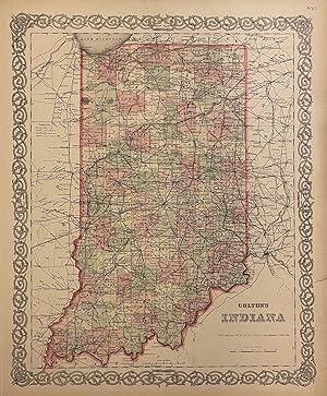
Verlag: G.W. and C.B. Colton, New York 1881
Anbieter: Argosy Book Store, ABAA, ILAB, New York, NY, USAArgosy Book Store, ABAA, ILAB
Verkäufer/-in kontaktierenVerkäufer/-in mit 5 SternenZustand: Gebraucht
EUR 111,07
EUR 5,18 VersandVersand innerhalb von USAAnzahl: 1 verfügbar
unbound. Map. Engraving with original hand coloring. Image measures 15 3/4" x 12 3/4". Nice map of Indiana divided into counties and townships with Colton's classic decorative border. Shows towns and cities, railroads, major routes, waterways and canals. In very good condition. Two closed tears at right margin, and minor toning…at edges. Otherwise clean and bright. The Colton family was one the most prolific and successful publishers of maps and atlases in the United States. J.H. Colton (1800-1893) founded his business in NYC in 1831.
 Weitere Bilder
Verlag: G.W. & C.B. Colton & Co., New York 1887
- Karte
Anbieter: Blind-Horse-Books (ABAA), DeLand, FL, USABlind-Horse-Books (ABAA)
Verkäufer/-in kontaktierenVerkäufer/-in mit 5 SternenZustand: Gebraucht - Gut
EUR 146,61
EUR 5,18 VersandVersand innerhalb von USAAnzahl: 1 verfügbar
Zustand: Very Good. A highly detailed late-19th-century cartographic survey of Maine, published specifically for the Maine State Year Book. This map captures the state's complex coastal topography and rapidly expanding interior transportation networks during the height of the Victorian industrial era. KEY FEATURES +++ Visuals: H…and-colored in pastel washes to delineate county boundaries; features an elaborate, stylized interlocking vine border characteristic of the Colton studio. +++ Binding: Originally issued as a folding map (as evidenced by standard folds); now flat. +++ Content: Includes a detailed 'Explanations' key identifying Railroads, Common Roads, Canals, County Towns, and Post Offices. +++ Associated Names: Published by the prestigious firm of G.W. & C.B. Colton at 312 Broadway, New York, for G.M. Donham of Portland. +++ Rarity: Uncommon in this crisp, hand-colored state; these maps were typically used heavily as reference tools in State Year Books and often survived with significant tanning or losses. +++ Imprint: Entered according to Act of Congress in the year 1887 by G.W. & C.B. Colton & Co. +++ Specs: 17 x 14 inches. CONDITION Very Good -- Standard folds as issued; minor edge wear and light creasing. Hand-coloring remains vivid and the paper is remarkably bright for a Victorian-era municipal map. HISTORICAL SIGNIFICANCE -- The Colton family defined American cartography for over 60 years. By 1887, their maps had moved beyond mere exploration into the realm of precise commercial and political tools. This specific map, produced for the Maine State Year Book, was the 'GPS' of its day for legislators, merchants, and industrialists navigating the Pine Tree State. It documents a pivotal moment in New England history where the 'Common Roads' were being superseded by the "Rail Roads" and 'Canals' that funneled timber and textiles to the Atlantic ports. For the New England collector, it is a primary document of the state's transition into the modern industrial age. SUBJECTS: Maine History, Cartography, Railroad History, G.W. & C.B. Colton, 19th Century Infrastructure, New England Geography, Portland Maine, Map, Engraving, Ephemera, Americana. BIBLIOGRAPHIC REFERENCE: Cf. Thompson, 'Maps of Maine' (for Colton iterations); Phillips, 'Maps of America'.

Verlag: New York 1867
Anbieter: Argosy Book Store, ABAA, ILAB, New York, NY, USAArgosy Book Store, ABAA, ILAB
Verkäufer/-in kontaktierenVerkäufer/-in mit 5 SternenZustand: Gebraucht - Gut
EUR 333,21
EUR 5,18 VersandVersand innerhalb von USAAnzahl: 1 verfügbar
unbound. Zustand: very good(+). Case map. Engraving with original hand coloring. Image measures 15.5" x 13". Rare and beautifully detailed map of Wisconsin divided into counties and townships. Showing all major routes, railroads and waterways. Includes an uncolored inset of Milwaukee and its vicinity. Repair to verso where map w…as hinged to booklet. A few small tears to edges. Two reinforced punch holes to bottom of border. Library stamp of the American Museum of Natural History on verso. Booklet missing. The Colton family was one the most prolific and successful publishers of maps and atlases in the United States.
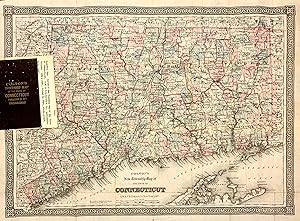
Verlag: G.W. & C.B. Colton & Co, New York 1887
Anbieter: Argosy Book Store, ABAA, ILAB, New York, NY, USAArgosy Book Store, ABAA, ILAB
Verkäufer/-in kontaktierenVerkäufer/-in mit 5 SternenZustand: Gebraucht
EUR 488,70
EUR 5,18 VersandVersand innerhalb von USAAnzahl: 1 verfügbar
unbound. Pocket map. Engraving with original hand coloring. Image measures 25" x 18.5". New York: G.W. & C.B. Colton & Co., 1870. This is a rare 1887 pocket map of Connecticut issues by Colton. Shows all of Connecticut with part of Massachusetts to the north, part of Rhode Island to the east, part of Long Island and the Long Isl…and Sound to the south, and part of New York to the west. The state is outlined in a think bright pink line, with counties outlined in thinner pink lines. Shows roads, rail lines, major routes, townships, and topographical details. Beautiful dark impression with vibrant original hand color. The map is attached to the original cloth binder. Some minor wear and toning along fold lines with minor repairs on verso. Otherwise in excellent condition. The Colton family was one the most prolific and successful publishers of maps and atlases in the United States. Joseph Hutchins Colton (1800-1893) founded his business in NYC in 1831.
 Weitere Bilder
Verlag: COLTON, G. W. and COLTON, C. B., New York 1869
Anbieter: Argosy Book Store, ABAA, ILAB, New York, NY, USAArgosy Book Store, ABAA, ILAB
Verkäufer/-in kontaktierenVerkäufer/-in mit 5 SternenZustand: Gebraucht
EUR 1.199,55
EUR 5,18 VersandVersand innerhalb von USAAnzahl: 1 verfügbar
unbound. Map. Engraving with hand coloring. Sheet measures 24 1/2" x 24 3/4" Rare elegant large scale map of the New York metropolitan area, including parts of New Jersey, Long Island, Connecticut, and Westchester and Rockland counties. Counties, townships, cities, post offices, and neighborhoods are labeled. Turnpike and common… roads, as well as canals and railroads are indicated. Centered on the island of Manhattan, the map features a circular shape to show a 33 mile radius, with concentric circles radiating outwards from the center. A beautiful floral decorative border surrounds the map, with vignettes of City Hall in New York and City Hall in Brooklyn in the bottom corners. Map drawn by G.W. Colton, and engraved by J.M. Atwood. This map is in very good condition. Toning and wear along original fold lines, with some archival repairs. Lined with Japanese tissue. The Colton family was one the most prolific and successful publishers of maps and atlases in the United States. Joseph Hutchins Colton (1800-1893) founded his map publishing business upon moving to New York in 1831. For the first two decades of his business, he found immense success publishing guide books marketed to emigrants and tourists. In 1855, he published the firm's first original atlas, "Colton's Atlas of the World", in collaboration with his son, George W. Colton (1827-1901). George and his brother, Charles B. Colton (1832-1916), assumed direction of the firm in the following decade. J.M. Atwood (illustrator).


