Gesamtpreis (1 Artikel Artikel):
Versandziel:

blaeu willem janszoon (227 Ergebnisse)
Feedback
Direkt zu den wichtigsten Suchergebnissen
Suchfilter
Produktart
- Alle Product Types
- Bücher (157)
- Magazine & Zeitschriften (Keine weiteren Ergebnisse entsprechen dieser Verfeinerung)
- Comics (Keine weiteren Ergebnisse entsprechen dieser Verfeinerung)
- Noten (Keine weiteren Ergebnisse entsprechen dieser Verfeinerung)
- Kunst, Grafik & Poster (21)
- Fotografien (Keine weiteren Ergebnisse entsprechen dieser Verfeinerung)
- Karten (49)
- Manuskripte & Papierantiquitäten (Keine weiteren Ergebnisse entsprechen dieser Verfeinerung)
Zustand Mehr dazu
- Neu (2)
- Wie Neu, Sehr Gut oder Gut Bis Sehr Gut (29)
- Gut oder Befriedigend (30)
- Ausreichend oder Schlecht (Keine weiteren Ergebnisse entsprechen dieser Verfeinerung)
- Wie beschrieben (166)
Weitere Eigenschaften
Sprache (4)
Gratisversand
Land des Verkäufers
Verkäuferbewertung
-
EUR 3,99
Währung umrechnenEUR 1,99 für den Versand von Tschechien nach DeutschlandAnzahl: 1 verfügbar
In den WarenkorbZustand: Fine. Leichte Risse.
Mehr Angebote von anderen Verkäufern bei ZVAB
Gebraucht ab EUR 5,98
-
EUR 3,99
Währung umrechnenEUR 1,99 für den Versand von Tschechien nach DeutschlandAnzahl: 1 verfügbar
In den WarenkorbHardcover. Zustand: Fine. Leichte Risse.
-

Deutschland vor drei Jahrhunderten : seine Städte, Flüsse u. Wälder. betrachtet von Willem u. Joan Blaeu [u. a.]. Mit e. Nachw. von C. Broekema
Verlag: Gütersloh, Berlin : Kartographisches Institut Bertelsmann, 1971
Sprache: Deutsch
Anbieter: Hübner Einzelunternehmen, Hamburg, HH, Deutschland
Verkäuferbewertung 5 von 5 Sternen

EUR 18,00
Währung umrechnenEUR 3,00 für den Versand innerhalb von/der DeutschlandAnzahl: 1 verfügbar
In den WarenkorbIll.Opd. 300 S. : überwiegend. Ill. u. Kt., , 30 cm In Fraktur. vord. einbanddeckel etw. fleckig Sprache: Deutsch Gewicht in Gramm: 1400.
-
Nova Totius Terrarum Orbis Geographica Ac Hydrographica Tabula auct Guiljelmo Blaeuw. Kolerierter Nachdruck. Motivgröße 12 x 16 cm // Blattgröße 20 x 25 cm //. Ungerasterter Druck mit Plattenrand auf starkem Bütten. Dekorative Karte, umrahmt mit bildlichen Darstellungen der vier Elemente, sieben Weltwunder, sieben Planeten und vier Jahreszeiten.
Verlag: Ohne Verlag, um 1970 ???, Ohne Ort,, 1970
Anbieter: Umbras Kuriositätenkabinett, Berlin, Deutschland
Verkäuferbewertung 5 von 5 Sternen
Kunst / Grafik / Poster
EUR 16,00
Währung umrechnenEUR 2,58 für den Versand innerhalb von/der DeutschlandAnzahl: 1 verfügbar
In den Warenkorb20 x 25 cm. 1 Blatt. . ISBN: Keine. Kartoniert / Soft cover. No jacket. Kartoniert / Soft cover. 1. Auflage. Sprache: de. * Versandfertig innerhalb von 20 Stunden! Meersburg ist eine Kleinstadt im baden-württembergischen Bodenseekreis. Sie liegt zwischen Friedrichshafen und Überlingen. R1B2. (Rad). Jpg.
-

EUR 24,95
Währung umrechnenKostenlos für den Versand innerhalb von/der DeutschlandAnzahl: 3 verfügbar
In den WarenkorbZustand: New. Farbenpraechtiger Nachdruck, Lieferung gerollt, Blattgroesse (B x H) 75 x 58 cm, Bedrucktes Blatt (B x H) 67 x 51 cm. Origilalmassstab ca. 1:92 000 000 - aber die Darstellung um 60 % vergroessert zum Original. Kartograph: Willem Janszoon Blaeu (1571-1638). Nova T.
Mehr Angebote von anderen Verkäufern bei ZVAB
Neu ab EUR 24,95
-

Three World Maps by Francois van den Hoeye of 1661, Willem Janszoon (Blaeu) of 1607, Claes Janszoon Visscher of 1650
Anbieter: Theologia Books, La Charite sur Loire, Frankreich
Verkäuferbewertung 4 von 5 Sternen

EUR 30,00
Währung umrechnenEUR 13,80 für den Versand von Frankreich nach DeutschlandAnzahl: 1 verfügbar
In den WarenkorbSoft cover. Zustand: Fine. Fine paperback copy. 55 X 44 cms. 51 pages of text, 18 plates. Book.
-
Blaeu. Der Grosse Atlas. Die Welt im 17. Jahrhundert. Einführung, Texte und Auswahl der Karten von John Goss. Vorwort von Peter Clark. Hrsg. in Zusammenarbeit mit der Royal Geographical Society, London.
Verlag: Neff Wien (), 1990
Anbieter: Heilbronner Antiquariat - Michael Wahl, Heilbronn, Deutschland
Verkäuferbewertung 5 von 5 Sternen
EUR 30,00
Währung umrechnenEUR 4,00 für den Versand innerhalb von/der DeutschlandAnzahl: 1 verfügbar
In den WarenkorbMit 100 farbigen Karten. 2°. 224 S. OPpbd. Schutzumschlag gering bestossen. Gutes Exemplar. *** 40 Jahre - Heilbronner Antiquariat - Michael Wahl - 1983-2023 ***.
-
Blaeu. Der Grosse Atlas. Die Welt im 17. Jahrhundert. Einführung, Texte und Auswahl der Karten von John Goss. Vorwort von Peter Clark. Hrsg. in Zusammenarbeit mit der Royal Geographical Society, London.
Verlag: Neff Wien (), 1990
Anbieter: Heilbronner Antiquariat - Michael Wahl, Heilbronn, Deutschland
Verkäuferbewertung 5 von 5 Sternen
EUR 30,00
Währung umrechnenEUR 4,00 für den Versand innerhalb von/der DeutschlandAnzahl: 1 verfügbar
In den WarenkorbMit 100 farbigen Karten. 2°. 224 S. OPpbd. Schutzumschlag leicht berieben. Gutes Exemplar. *** 40 Jahre - Heilbronner Antiquariat - Michael Wahl - 1983-2023 ***.
-
EUR 51,35
Währung umrechnenKostenlos für den Versand von USA nach DeutschlandAnzahl: 2 verfügbar
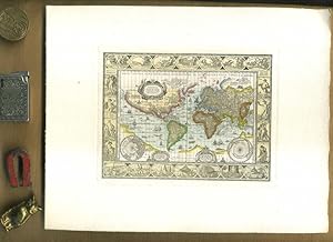
In den Warenkorb1st Edition in this form. Fine paperback copy. Particularly and surprisingly well-preserved; tight, bright, clean and especially sharp-cornered.; 8vo 8" - 9" tall; 0 pages; Description: 17 leaves, A-V leaves of plates : ill., maps ; 56 cm. Includes bibliographical references. Reprint of the 1624 map by W. J. Blaeu, as revised and published by J. Hondius, Amsterdam. Title of original map reads: Nova universi terrarum orbis mappa. Series: Wall-maps of the 16th and 17th centuries ; 1. Subjects: World maps --Early works to 1800 --Early maps. 3 Kg.
-
Rhenvs fluviorum Europae celeberrimus, cum Mosa, Mosella, et reliquis, in illum se exponerantibus fluminibus
Anbieter: Antiquariat Lang, Rennerod, Deutschland
Verkäuferbewertung 4 von 5 Sternen
EUR 30,00
Währung umrechnenEUR 3,00 für den Versand innerhalb von/der DeutschlandAnzahl: 1 verfügbar
In den WarenkorbFarbige faksimilierte Rheinkarte aus K. Stopp: Die monumentalen Rheinlaufkarten aus der Blütezeit der Kartographie. Wiesbaden: Kalle, (1975). - 51 x 108, einmal gefaltet 51 x 53,5. * Sehr gut erhalten. - Diese Rheinlaufkarte von W. Blaeu gehört zu den schönsten des Barocks, reich verziert durch zehn, von Putten gehaltenen Wappen derjenigen Gebiete, die der Rhein umschließt.
-
![Bild des Verkäufers für Namur / Namür / Hennegau. - Historische Kupferstichkarte. Comitatuum Hannoniae et Namurci descriptio. [Grafschaft Hennegau, frz: Hainaut in Belgien nebst angrenzender Gebiete. Wahrscheinlich aus: van der Krogt, Koeman's Atlantes Neerlandici, Vol. I.] zum Verkauf von Antiquariat Carl Wegner](https://pictures.abebooks.com/inventory/md/md14339280276.jpg)
Namur / Namür / Hennegau. - Historische Kupferstichkarte. Comitatuum Hannoniae et Namurci descriptio. [Grafschaft Hennegau, frz: Hainaut in Belgien nebst angrenzender Gebiete. Wahrscheinlich aus: van der Krogt, Koeman's Atlantes Neerlandici, Vol. I.]
Verlag: [Johannes Janssonius (Jansson). Amsterdam, 1636.], 1636
Sprache: Latein
Anbieter: Antiquariat Carl Wegner, Berlin, B, Deutschland
Verbandsmitglied: GIAQ
Verkäuferbewertung 5 von 5 Sternen
Erstausgabe
EUR 57,00
Währung umrechnenKostenlos für den Versand innerhalb von/der DeutschlandAnzahl: 1 verfügbar
In den WarenkorbSoftcover. Kartengröße: 49 x 51,5 cm. Oben links einEngel die Meilenanzeige haltend, unten rechts die Titelkartusche von zwei Wappen flankiert: rechts vier Löwen unter einer Krone (das Wappen von Hennegau), rechts ein Löwe unter einer Krone (das Wappen Belgiens). Im unteren Randbereich ein 2 cm langer Einriss, der bis in die Karte hineinreicht, sonst im Randbereich kleinere Fehlstellen und Einrisse. Der Kartenbereich im unteren rechten Eck nur in der Randung mit Längen- und Breitengraden etwas abgerieben. Weiterhin auf der Karte: Wallonien, Mons, Teile von Brabant begrenzt durch Oudenaarde, Huy und Cambrai, oben links Flandern. - Versand als Rolle zu 5.-Euro. - -- Bitte Portokosten außerhalb EU erfragen! / Please ask for postage costs outside EU! / S ' il vous plait demander des frais de port en dehors de l ' UE! // Bitte beachten Sie auch unsere Fotos! / Please also note our photos! / Veuillez noter nos photos -- Genießen Sie ein gutes Buch auf einer Sommerwiese oder im kühlen Schatten bei einem erfrischenden Getränk. Fe2Klavier.
-

Blaeu's Atlas of England, Scotland, Wales and Ireland;
Anbieter: Antipodean Books, Maps & Prints, ABAA, Garrison, NY, USA
Verbandsmitglied: ABAA ANZAAB ESA ILAB
Verkäuferbewertung 5 von 5 Sternen
EUR 390,95
Währung umrechnenEUR 30,84 für den Versand von USA nach DeutschlandAnzahl: 1 verfügbar
In den WarenkorbZustand: Fine in near fine slipcase. Limited edition. with an Introduction by R. V. Tooley and 115 Maps of Which 5 are coloured and Blaeu's title Pages in Colour. Elephant folio, unpaginated. Facsimile reprint of maps of John Blaeu of 1645 and 1654; a limited edition of 500 copies, of which this is number 242. Brown cloth covers, half red leather, with gilt rules, and gilt title on red spine. In a custom gray slipcase with dark brown edges; very good condition. Internally immaculate. Tooley states in the introduction, "known as the foremost mapmakers of their time, their fame was not confined to their native country of Holland, but reached into most of the cultured and leisured circles of Europe and even further, sumptuous examples of their atlases being sent as princely gifts to oriental potentates and ministers, as a symbol of the Republic of the United Netherlands.".
-

Blaeu's Atlas von Deutschland. Limmitierte Faksimileausgabe Nr. 366 von 500 Exemplaren.
Verlag: Gütersloh ; Berlin : Kartographisches Institut Bertelsmann , 1972, 1972
ISBN 10: 3570045439 ISBN 13: 9783570045435
Anbieter: Wissenschaftliches Antiquariat Köln Dr. Sebastian Peters UG, Köln, Deutschland
Verkäuferbewertung 5 von 5 Sternen
EUR 90,00
Währung umrechnenEUR 4,00 für den Versand innerhalb von/der DeutschlandAnzahl: 1 verfügbar
In den WarenkorbHalbledereinband. Zustand: wie neu. XXII, 97 Kt. z. T. farb., 54 cm, Halbledereinband im orig. Ganzleinenschuber. Mit einer Einleitung von R. V. Tooley und C. Broekema. Sprache: deu.
-
COLONIENSIS ARCHIEPISCOPATUS. Blaeuw Karte.
Verlag: Blaeuw um 1660. *Altkoloriertes Blatt 58x48., 1660
Anbieter: Antiquariat Bergische Bücherstube Mewes, Overath, Deutschland
Verbandsmitglied: GIAQ ILAB VDA
Verkäuferbewertung 5 von 5 Sternen
EUR 58,00
Währung umrechnenEUR 6,00 für den Versand innerhalb von/der DeutschlandAnzahl: 1 verfügbar
In den Warenkorbcm* in der Mitte gefalzt, hinterlegt, eingerrissen*. rückseitig bedruckt* leicht gebräunt, abgesehen von dem restaurierungswürdigem Mittelfalz schönes Blatt*.
-
Lieroort [Leerort]. Befestigungsplan mit dem Flußlauf von Ems und Leda. Orig.-Kupferstich.
Verlag: Amsterdam, um 1650., 1650
Sprache: Deutsch
Anbieter: Antiquariat Hecht, Leer, NDS, Deutschland
Verbandsmitglied: GIAQ
Verkäuferbewertung 5 von 5 Sternen
Karte
EUR 143,90
Währung umrechnenEUR 3,50 für den Versand innerhalb von/der DeutschlandAnzahl: 1 verfügbar
In den Warenkorbca. 33 x 22 cm, Zustand: Sehr gut. Aus dem Stedenboek der Brüder Blaeu. Einige kl. Flecken, sonst sehr guter Zustand. Lieferung unter Passepartout. /krippe Sprache: Deutsch Gewicht in Gramm: 2100.
-

Palatinatus Bavariae. Kupferstich-Karte von Blaeu, Oberpfalz nördlich der Donau. Mittelpunkt: Dietldorf
Verlag: Excudit Guiljelmus Blaeuw 0, Amsterdam
Anbieter: Antiquariat Kastanienhof, Pirna, Deutschland
Verkäuferbewertung 5 von 5 Sternen
EUR 99,00
Währung umrechnenEUR 4,41 für den Versand innerhalb von/der DeutschlandAnzahl: 1 verfügbar
In den WarenkorbSoftcover. Zustand: Gut. 38 x 50 cm Alle unsere Graphiken sind Originalstiche aus der angegebenen Zeit und befinden sich in gutem Zustand, soweit nicht anders beschrieben oder abgebildet Mittelfalz, trčs bon état, gut erhaltenes Exemplar---"Rechts unten manieristische Titelkartusche mit Grotesken, rechts daneben Meilenzeiger, links daneben Druckvermerk "Excudit Guiljelmus Blaeuw.". Mit niederländischem Rückentext." Für Ihre Zufriedenheit versenden wir mit DHL und ausschließlich mit Trackingcode für eine sichere Sendungsverfolgung! Weitere Angebote unter antiquariat-kastanienhof , 2 Seiten. nein.
-
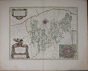
"Territorium Norimbergense". Kupferstich mit zwei zeitgenössisch kolorierten dekorativen Kartuschen und rechts unten mit einer Gesamtansicht von Nürnberg aus der Vogelschau sowie mit zeitgenössischenm Grenz- und Landschaftskolorit.
Verlag: Amsterdam, ex. Guiljelm Blaeuw ca. 1640., 1640
Sprache: Deutsch
Anbieter: Antiquariat Braun, Gengenbach, Deutschland
Verkäuferbewertung 5 von 5 Sternen
Karte
EUR 220,00
Währung umrechnenEUR 6,00 für den Versand innerhalb von/der DeutschlandAnzahl: 1 verfügbar
In den WarenkorbZustand: Sehr gut. 36,5 x 47 cm. Blattgröße: 50 x 61 cm. *Rückseitig ohne Text. Breitrandiges sehr gut erhaltenes Exemplar, lediglich am Unterrand leicht fingerfleckig. Sprache: Deutsch Gewicht in Gramm: 1000.
-
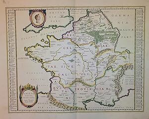
Gallia vetus, ad Jul. Caesaris commentaria ex conatibus geographicis Abrah Ortelii. Altkol. Kupferstichkarte von Willem Janszoon Blaeu, 1635.
Sprache: Deutsch
Anbieter: Altstadt Antiquariat M. Weiers, Freiburg, Deutschland
Verkäuferbewertung 5 von 5 Sternen
Kunst / Grafik / Poster
EUR 330,00
Währung umrechnenEUR 3,80 für den Versand innerhalb von/der DeutschlandAnzahl: 1 verfügbar
In den WarenkorbHardcover. Zustand: Gut. 38,5 x 49,5 cm. Mit schönem Altkolorit. Von sehr guter Erhaltung. 11790 [L] Sprache: Deutsch Gewicht in Gramm: 100.
-
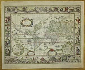
Nova totius Terrarum Orbis Geographica ac Hydrographica tabula. Altkolorierte Kupferstichkarte von J. van den Ende aus:
Verlag: Amsterdam, Blaeu, ca. 1635., 1635
Sprache: Deutsch
Anbieter: Matthaeus Truppe Antiquariat, Graz, Österreich
Verkäuferbewertung 5 von 5 Sternen
Karte
EUR 11.556,00
Währung umrechnenEUR 8,00 für den Versand von Österreich nach DeutschlandAnzahl: 1 verfügbar
In den WarenkorbCa. 41 cm x 55,5 cm. Koeman Bl 5, 1. Shirley 255. - Der vierte Zustand (Guiljelmo Blaeuw und ohne Datierung) dieser wohl shönsten Weltkarte des 17. Jahrhunderts. "It is celebrated as one of the supreme examples of the map maker`s art" (Shirley, S. 270). - Die Weltkarte, nach Mercators Projektion, ist umgeben von 4 Bildleisten und 2 kleinen Polkarten am unteren Rand. An den Seiten Allegorien der 4 Jahreszeiten und Elemente, am oberen Rand mittig Allegorie auf die Sonne flankiert von Allegorien des Mondes und von 5 Planeten, am unteren Rand Darstellung der sieben Weltwunder. Interessant auch der kurze Text zur Entdeckung von Amerika in der Kartusche. - Verso deutscher Text. - Leicht gebräunt und fleckig. Restaurierte Läsuren in den Rändern und im Falz. Die beiden oberen Ecken mit ergänzten Einrissen (aber ohen Bildberührung). Im Bereich von "Brasilien" 2 kleine (ca. 2 cm x 0,3 cm und 1,5 cm x 0,2 cm) hinterlegte Einrisse (minimalster Buchstabenverlust und einige Millimeter ergänzter Flußlauf). *** *** Copyright: Matthaeus TRUPPE Buchhandlung & Antiquariat - Stubenberggasse 7 - A-8010 Graz - ++43 (0)316 - 829552 *** *** Sprache: Deutsch Gewicht in Gramm: 0 Willem J. und Joan Blaeu, Novus Atlas, Das ist Weltbeschreibung.
-
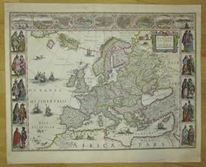
Europa recens descripta. Altkolorierte Kupferstichkarte aus:
Verlag: Amsterdam, Blaeu, ca. 1635., 1635
Sprache: Deutsch
Anbieter: Matthaeus Truppe Antiquariat, Graz, Österreich
Verkäuferbewertung 5 von 5 Sternen
Karte
EUR 3.745,00
Währung umrechnenEUR 8,00 für den Versand von Österreich nach DeutschlandAnzahl: 1 verfügbar
In den WarenkorbCa. 41 cm x 55,5 cm. Koeman Bl 5, 2. - Eine der dekorativsten Europakarten des 17. Jahrhunderts in der früheren Variante mit der fiktiven Insel Frisland westlich von Island. Am linken und rechten Rand jeweils 5 Trachtenpaare aus 10 verschiedenen Ländern. Am oberen Rand eine Leiste mit Stadtansichten von Amsterdam, Prag, Istanbul, Venedig, Rom, Paris, London, Toledo und Lissabon. - Verso deutscher Text. - Leicht gebräunt und fleckig. Kl. restaurierte Läsuren in den Rändern und im Falz. *** *** Copyright: Matthaeus TRUPPE Buchhandlung & Antiquariat - Stubenberggasse 7 - A-8010 Graz - ++43 (0)316 - 829552 *** *** Sprache: Deutsch Gewicht in Gramm: 0 Willem J. und Joan Blaeu, Novus Atlas, Das ist Weltbeschreibung.
-

Americae nova Tabula. Altkolorierte Kupferstichkarte aus:
Verlag: Amsterdam, Blaeu, ca. 1635., 1635
Sprache: Deutsch
Anbieter: Matthaeus Truppe Antiquariat, Graz, Österreich
Verkäuferbewertung 5 von 5 Sternen
Karte
EUR 5.136,00
Währung umrechnenEUR 8,00 für den Versand von Österreich nach DeutschlandAnzahl: 1 verfügbar
In den WarenkorbCa. 41 cm x 55,5 cm. Koeman Bl 5, 5. Burden 189 (3. Zustand). - "Die Karte ist reich verziert: Am oberen Rand befinden sich Stadtpläne und Ansichten von Havanna, Santo Domingo, Cartagena, Mexiko, Cuzco, der Silberminenstadt Potosi, der Insel Mocha (Chile), von Rio de jeneiro und Olinda; links die Trachten der bewohner Nordamerikas - aus Grönland, Virginia und Mexiko - sowie der König und die Königin von Florida und der König von Neu-Albion dagestellt; rechts sind die Trachten Südamerikas - aus Peru und Brasilien sowie der Insel Mocha in Chile und derer des Gebietes der Magellanstrasse - wiedergegeben. Bei einer Nebenkarte finden sich folgende Erläuterungen: `Die nördlichsten Teile von Amerika, nämlich Grönland, Island und die angrenzenden Gebiete, die nicht gut in die Karte von Amerika aufgenommen werden konnten, zeigen wir dem Betrachter mit dieser gesonderten karte`." (Blaeu, Atlas Maior of 1665. Introduction by Peter van der Krogt) S. 474). - Verso deutscher Text. - Leicht gebräunt und fleckig. *** *** Copyright: Matthaeus TRUPPE Buchhandlung & Antiquariat - Stubenberggasse 7 - A-8010 Graz - ++43 (0)316 - 829552 *** *** Sprache: Deutsch Gewicht in Gramm: 0 Willem J. und Joan Blaeu, Novus Atlas, Das ist Weltbeschreibung.
-
Willem Janszoon Blaeu (1573 - 1638). The greatest globe maker of the Dutch Golden Age.
Anbieter: Antiquariaat Wim de Goeij, Kalmthout, ANTW, Belgien
Verbandsmitglied: ILAB
Verkäuferbewertung 5 von 5 Sternen
EUR 38,00
Währung umrechnenEUR 15,50 für den Versand von Belgien nach DeutschlandAnzahl: 1 verfügbar
In den Warenkorb2. Bergen (Noord-Holland), Rob Kattenburg, s.d. (ca. 2010 ), oblong format , in-4°, 22 x 32 cm, 16 nn pp, colour ills. stapled, original illustrated wrapper. Presentation trade catalogue for a pair of globes made by Blaeu, with an informative description.
-
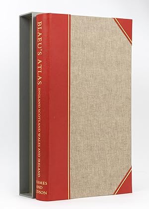
Blaeu's Atlas of England, Scotland, Wales and Ireland
Verlag: Thames and Hudson, London, 1970
Anbieter: Michael Treloar Booksellers ANZAAB/ILAB, Adelaide, SA, Australien
Verkäuferbewertung 5 von 5 Sternen
EUR 287,46
Währung umrechnenEUR 18,55 für den Versand von Australien nach DeutschlandAnzahl: 1 verfügbar
In den WarenkorbHardcover. Zustand: Fine. London, Thames and Hudson, [1970s] (facsimile edition)/ 1645 and 1654. Folio, [xvi] pages plus 115 double-page maps (5 in colour) and 2 facsimile colour title pages (all plates printed one side of each leaf only). Half morocco and cloth; tiny light mark to the leading edge; endpapers slightly discoloured by the leather turn-ins; essentially a fine copy with the lightly scuffed slipcase. Number 26 of only 500 copies; with an introduction by R.V. Tooley.
-
Anglia Regnum
Verlag: Amsterdam, 1634
Anbieter: Clive A. Burden Ltd., Chalfont St. Giles, BUCKS, Vereinigtes Königreich
Verkäuferbewertung 2 von 5 Sternen

Karte
EUR 306,71
Währung umrechnenEUR 19,64 für den Versand von Vereinigtes Königreich nach DeutschlandAnzahl: 1 verfügbar
In den WarenkorbNo binding. 385 x 495 mm., early outline colour, with Spanish text, with tear to the upper margin repaired, in good condition. The Blaeu firm's first topographical atlas appeared in 1630 in one volume and was gradually expanded. By 1640 it was in three volumes and contained just 4 British Isles maps. His chief rival, the Hondius-Jansson atlas contained 18 maps. Both joined a race to make their fourth volumes a complete atlas of the British Isles. Blaeu was first, publishing his magnificent work in 1645. Of the general maps contained Blaeu was also the first to produce one of England and Wales first appearing in 1634. The map is derived from that of John Speed although hear lacking the figures along the sides as befitted the new style being set by the Dutch mapmakers. It is however beautifully decorated with the coats of arms of Great Britain and Ireland along with an ornate scale and title cartouche. There is known to exist a proof state of this map, so technically this is a second state, with Spanish text as issued in 1659. Koeman (1967-70) Bl. 5 no. 107 p. 89; Shirley (1991) no. 440; Van der Krogt, P. (Atlantes) 5100:2.
-
![Bild des Verkäufers für [Mapa de Aragón] Arragonia Regnum zum Verkauf von Bolivar Old Prints Anticuario](https://pictures.abebooks.com/inventory/md/md32007402304.jpg)
[Mapa de Aragón] Arragonia Regnum
Verlag: Amsterdam, 1643
Anbieter: Bolivar Old Prints Anticuario, Barcelona, B, Spanien
Verkäuferbewertung 4 von 5 Sternen
Karte
EUR 450,00
Währung umrechnenEUR 20,00 für den Versand von Spanien nach DeutschlandAnzahl: 1 verfügbar
In den WarenkorbSin Encuadernar - No binding. Zustand: Bueno. Mapa de Aragón Joao Baptista Lavanha [Labańa], c. 1642. Muestra la imagen más antigua de Aragón, dibujada con procedimientos científicos de su época. En el siglo XVII, las autoridades ibéricas se apresuraron a editar mapas modernos de sus reinos, pues ya no confiaban en la información de segunda mano ni estaban satisfechas con la cartografía peninsular de finales del siglo XVI realizada por Pedro Esquivel. Ya en 1613-1614, el cartógrafo Juan Baptista Labańa (conocido tambien por su nombre portugés Joăo Baptista Lavanha), por encargo del Reino de Aragón, había terminado de cartografiar su territorio. Este mapa de Lavańa ofrece al viajero una visión más precisa de la ubicación de las montańas y ríos de Aragón. La plancha original del mapa fue producida hacia 1620 en Madrid, y las copias posteriores se derivaron de ella. Aunque hace hincapié en las jurisdicciones eclesiásticas, el mapa se centra en Zaragoza y se extiende hasta Calahorra y Cuenca al oeste, Pamplona al norte y Lérida al este. Una cartela rematada por un escudo de armas encierra el título del mapa y una inscripción en latín. En una segunda cartela, rematada por un escudo de armas, figura una mención dedicatoria a Gaspari Charles. Hay seis escudos de armas repartidos por el mapa. Escala en una cartela en la parte superior del mapa. Grabado orignal en cobre, iluminado a mano. ------------------------------------------------------- A hand-coloured map of Aragon by Joao Baptista Lavanha [Labanna], [1642?] 17th century. The map shows the oldest image of Aragon, drawn using scientific procedures of its time. In the 17th century, the Iberian authorities raced to issue modern maps of their realms, as they no longer relied on second-hand information or were no more satisfied with the peninsula's late 16th-century mapping by Pedro Esquivel. As soon as 1613-1614, Portuguese cartographer Lavanha, commissioned by Aragon, had finished mapping their kingdom. This map from Lavanha gives the traveller a better view of the lie of the mountains and rivers in Aragon. The map's original plate was produced circa 1620 in Madrid, and subsequent copies were derived from it. While emphasizing ecclesiastical jurisdictions, the map is centered around Zaragoza, extending to Calahorra and Cuenca in the west, Pamplona in the north, and Lerida in the east. A cartouche capped by a coat of arms encloses the map's title and a Latin inscription. A dedicatory mention to Gaspari Charles is enshrined in a second cartouche topped by a coat of arms. Six coats of arms are scattered across the map. Scale in a cartouche in the upper part of the map. FRA. Excellent.
-
[Mapa de Galicia, Espańa] Gallaecia Regnum descripta a F.Fer. Ojea Ord. Pred.
Verlag: Amsterdam, 1640
Anbieter: Bolivar Old Prints Anticuario, Barcelona, B, Spanien
Verkäuferbewertung 4 von 5 Sternen
Karte
EUR 480,00
Währung umrechnenEUR 20,00 für den Versand von Spanien nach DeutschlandAnzahl: 1 verfügbar
In den WarenkorbNo Binding. Zustand: Bueno. 38 x 51 cm. Decorativo mapa del reino de Galicia de Blaeu. Se extiende desde la región de Asturias de Oviedo y Avilés en el noreste, hasta Bayona y la frontera con Portugal en el sur. Al centro, Santiago de Compostela; destaca también la Coruńa, Pontevedra, Mondońedo, Lugo y Orense. Lleno de detalles como castillos, ciudades amuralladas, pueblos, ríos y montańas. Contiene un cartouche decorativo con un escudo de armas sostenido por dos querubines y uno más que representa a Neptuno sosteniendo el título. Se pueden apreciar también dos rosas de los vientos, tres embarcaciones y un monstruo marino, muy característicos de la cartografía holandesa de esta época. Willem Janszoon Blaeu (1571-1638) fue un prominente editor y geógrafo holandés. Estudió con el famoso astrónomo danés Tycho Brahe y estableció una tienda de globos, mapas e instrumentos de astronomía en Ámsterdam. En su faceta como editor publicó obras de intelectuales como Descartes y Hugo Grotius. En 1635 publicó su famosísimo atlas Theatrum Orbis Terrarum, sive, Atlas novus. Tres ańos más tarde, Blaeu murió y heredó su firma editorial a sus hijos Cornelius y Johannes, con quienes siguió prosperando. Dutch map of Galicia, Spain. Full English description upon request.". FRA. Muy bien.
-
[Mapa de las Islas Baleares, Espańa] Insulae Balearides et Pytiusae
Verlag: Amsterdam, 1640
Anbieter: Bolivar Old Prints Anticuario, Barcelona, B, Spanien
Verkäuferbewertung 4 von 5 Sternen
Karte
EUR 580,00
Währung umrechnenEUR 20,00 für den Versand von Spanien nach DeutschlandAnzahl: 1 verfügbar
In den WarenkorbZustand: Bueno. 38 x 50 com (grabado/engraving); 49,5 x 59 cm (hoja/sheet). Muy bello y decorativo mapa de las Islas Baleares: Mallorca, Menorca e Ibiza, con la costa de Cataluńa. Descripción de las islas Baleares en latín al verso. En la parte continental están identificadas las ciudades de Valencia, Tortosa, Tarragona y Barcelona. Fue incluido en el notable Atlas Novus, la obra más significativa de Blaeu y uno de los mejores atlas de la historia. Coloreado a mano, incluye un elegante título sobre un listón, dos escudos de armas, dos pequeńas rosas de los vientos, algunas embarcaciones y monstruos marinos, muy característicos de la cartografía holandesa del siglo XVII. Willem Janszoon Blaeu (1571-1638) fue un prominente editor y geógrafo holandés. Estudió con el famoso astrónomo danés Tycho Brahe y estableció una tienda de globos, mapas e instrumentos de astronomía en Ámsterdam. En su faceta como editor publicó obras de intelectuales como Descartes y Hugo Grotius. En 1635 publicó su famosísimo atlas Theatrum Orbis Terrarum, sive, Atlas novus. Tres ańos más tarde, Blaeu murió y heredó su firma editorial a sus hijos Cornelius y Johannes, con quienes siguió prosperando. Colores originales, amplios margenes.Dutch map of the Balearic Islands, Spain. Full English description upon request. Latin. Macha de oxidacion que produjó un pequeńo hueco (cerca de 3 x 6 mm) en el margen superior izquerdo, lejos de la imagen. Del resto, mapa en buen estado. . 38 x 50 com (grabado/engraving); 49,5 x 59 cm (hoja/sheet).
-
![Bild des Verkäufers für [Mapa de Aragón, Espańa] Episcopatus Balbastrensis zum Verkauf von Bolivar Old Prints Anticuario](https://pictures.abebooks.com/inventory/md/md31212703599.jpg)
[Mapa de Aragón, Espańa] Episcopatus Balbastrensis
Verlag: Amsterdam, 1640
Anbieter: Bolivar Old Prints Anticuario, Barcelona, B, Spanien
Verkäuferbewertung 4 von 5 Sternen
Karte
EUR 640,00
Währung umrechnenEUR 20,00 für den Versand von Spanien nach DeutschlandAnzahl: 1 verfügbar
In den WarenkorbNo Binding. Zustand: Bueno. 38 x 52 cm. Lindo y decorativo ejemplar de este mapa de Blaeu de Aragón, orientado con el oeste hacia arriba y con la ciudad de Barbastro, en Huesca, al centro. Los montes Pirineos aparecen del lado derecho del mapa. Colores originales plasmados a mano y con aplicaciones de hoja de oro. Bello cartouche decorativo con pequeńos putti. Willem Janszoon Blaeu (1571-1638) fue un prominente editor y geógrafo holandés. Estudió con el famoso astrónomo danés Tycho Brahe y estableció una tienda de globos, mapas e instrumentos de astronomía en Ámsterdam. En su faceta como editor publicó obras de intelectuales como Descartes y Hugo Grotius. En 1635 publicó su famosísimo atlas Theatrum Orbis Terrarum, sive, Atlas novus. Tres ańos más tarde, Blaeu murió y heredó su firma editorial a sus hijos Cornelius y Johannes, con quienes siguió prosperando. Título completo: Episcopatus Balbastrensis, Ribagorça Comit et Sobrarbe cum Adjecentibus. Dutch map of Aragon, Spain, with the Pyrenees mountains. Full English description upon request. FRA. Muy bien.
-
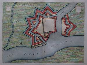
Roeroordt
Erscheinungsdatum: 1649
Sprache: Deutsch
Anbieter: Kunstantiquariat Andreas Senger, Hamburg, Deutschland
Verkäuferbewertung 4 von 5 Sternen
Kunst / Grafik / Poster
EUR 175,00
Währung umrechnenEUR 7,00 für den Versand innerhalb von/der DeutschlandAnzahl: 1 verfügbar
In den WarenkorbKein Einband. Zustand: Sehr gut. Es handelt sich hierbei um einen originalen, kolorierten Kupferstichplan der Befestigungsanlagen der Gemeinde Duisburg-Ruhrort von Willem Janszoon Blaeu (1571 - 1638) aus dem Jahr 1649. *** Titel: Roeroordt *** Gebiet bzw. Ort: Duisburg-Ruhrort *** Kartograph: Willem Janszoon Blaeu (1571 - 1638) *** Jahr: 1649 *** Größe des Plattenbereichs: 37 x 50 cm *** Technik: Kupferstich *** Zustand (Perfekt/ Sehr gut/ Gut/ Ordentlich/ Mäßig/ Schlecht): In sehr gutem Erhaltungszustand *** Bemerkungen: Plan der Befestigungsanlagen und der Umgebung - - - International buyers welcome. If you have any questions, please don't hesitate to ask. --- Auf Wunsch stellen wir Ihnen gerne ein kostenfreies Echtheitszertifikat aus --- If you wish, we will gladly provide a certificate of authenticity free of charge ---.
-
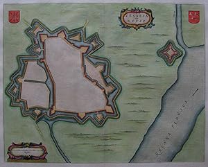
Vesalia vulgo Wesel
Erscheinungsdatum: 1649
Sprache: Deutsch
Anbieter: Kunstantiquariat Andreas Senger, Hamburg, Deutschland
Verkäuferbewertung 4 von 5 Sternen
Kunst / Grafik / Poster
EUR 199,00
Währung umrechnenEUR 7,00 für den Versand innerhalb von/der DeutschlandAnzahl: 1 verfügbar
In den WarenkorbKein Einband. Zustand: Sehr gut. Es handelt sich hierbei um einen originalen, kolorierten Kupferstichplan der Befestigungsanlagen der Stadt Wesel von Willem Janszoon Blaeu (1571 - 1638) aus dem Jahr 1649. *** Titel: Vesalia vulgo Wesel *** Gebiet bzw. Ort: Wesel *** Kartograph: Willem Janszoon Blaeu (1571 - 1638) *** Jahr: 1649 *** Größe des Plattenbereichs: 41 x 52 cm *** Technik: Kupferstich *** Zustand (Perfekt/ Sehr gut/ Gut/ Ordentlich/ Mäßig/ Schlecht): In sehr gutem Erhaltungszustand *** Bemerkungen: Plan der Befestigungsanlagen und der Umgebung - - - International buyers welcome. If you have any questions, please don't hesitate to ask. --- Auf Wunsch stellen wir Ihnen gerne ein kostenfreies Echtheitszertifikat aus --- If you wish, we will gladly provide a certificate of authenticity free of charge ---.


![Bild des Verkäufers für Lieroort [Leerort]. Befestigungsplan mit dem Flußlauf von Ems und Leda. Orig.-Kupferstich. zum Verkauf von Antiquariat Hecht](https://pictures.abebooks.com/inventory/md/md30519968837.jpg)
![Bild des Verkäufers für [Mapa de Galicia, Espańa] Gallaecia Regnum descripta a F.Fer. Ojea Ord. Pred. zum Verkauf von Bolivar Old Prints Anticuario](https://pictures.abebooks.com/inventory/md/md31212703600.jpg)
![Bild des Verkäufers für [Mapa de las Islas Baleares, Espańa] Insulae Balearides et Pytiusae zum Verkauf von Bolivar Old Prints Anticuario](https://pictures.abebooks.com/inventory/md/md32218705319.jpg)