Gesamtpreis (1 Artikel Artikel):
Versandziel:

blaeu willem janszoon (293 Ergebnisse)
Produktart
- Alle Product Types
- Bücher (202)
- Magazine & Zeitschriften
- Comics
- Noten
- Kunst, Grafik & Poster (20)
- Fotografien
- Karten (70)
- Manuskripte & Papierantiquitäten (1)
Zustand
Einband
Weitere Eigenschaften
Gratisversand
- Versand nach USA gratis
Land des Verkäufers
Verkäuferbewertung
-

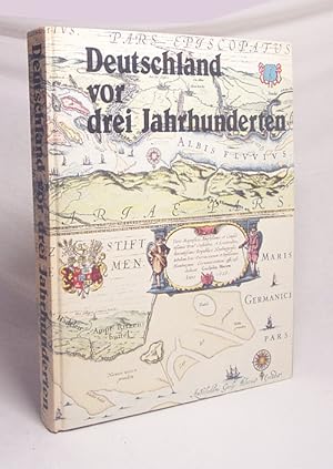
Deutschland vor drei Jahrhunderten. Seine Städte, Flüsse und Wälder
Verlag: Gütersloh, Berlin, Kartographisches Institut Bertelsmann, 1971., 1971
ISBN 10: 357008888XISBN 13: 9783570088883
Buch
Hardcover. Zustand: Comme neuf. Ammareal reverse jusqu'ŕ 15% du prix net de cet article ŕ des organisations caritatives. ENGLISH DESCRIPTION Book Condition: Used, As new. Ammareal gives back up to 15% of this item's net price to charity organizations.
Mehr Angebote von anderen Verkäufern bei ZVAB
Gebraucht ab EUR 5,25
-
Deutschland vor drei Jahrhunderten : seine Städte, Flüsse und Wälder / betrachtet von Willem und Joan Blaeu. Mit einem Nachw. von C. Broekema
Verlag: Prisma-Verlag 1987 Gütersloh, 1987
ISBN 10: 3570098516ISBN 13: 9783570098516
Buch
Pp. 30 cm Gut kein Schutzumschlag 306 S. / Sprache: deutsch / 1280 g / Zustand: Einband an Ecken minimal gestoßen, Schmutzblatt fehlt, Buchblock in Ordnung.
-
Historische WELTKARTE 1635 - Willem Janszoon Blaeu (Plano)
Verlag: Rockstuhl Verlag, 2013
ISBN 10: 3867776105ISBN 13: 9783867776103
Buch
sheet map. Zustand: New. Language: ger.
Mehr Angebote von anderen Verkäufern bei ZVAB
Neu ab EUR 24,16
-

Deutschland vor drei Jahrhunderten : seine Städte, Flüsse u. Wälder. betrachtet von Willem u. Joan Blaeu [u. a.]. Mit e. Nachw. von C. Broekema
Verlag: Gütersloh, Berlin : Kartographisches Institut Bertelsmann,, 1971
Buch
Ill.Opd. 300 S. : überwiegend. Ill. u. Kt., , 30 cm In Fraktur. vord. einbanddeckel etw. fleckig Sprache: Deutsch Gewicht in Gramm: 1400.
-
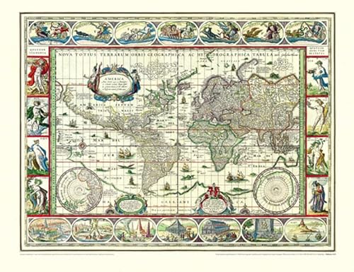
Nova Totius Terrarum Orbis Geographica Ac Hydrographica Tabula auct Guiljelmo Blaeuw. Kolerierter Nachdruck. Motivgröße 12 x 16 cm // Blattgröße 20 x 25 cm //. Ungerasterter Druck mit Plattenrand auf starkem Bütten. Dekorative Karte, umrahmt mit bildlichen Darstellungen der vier Elemente, sieben Weltwunder, sieben Planeten und vier Jahreszeiten.
Verlag: Ohne Verlag, um 1970 ???, Ohne Ort,, 1970
Kunst / Grafik / Poster
20 x 25 cm. 1 Blatt. . ISBN: Keine. Kartoniert / Soft cover. No jacket. Kartoniert / Soft cover. 1. Auflage. Sprache: de. * Versandfertig innerhalb von 20 Stunden! Meersburg ist eine Kleinstadt im baden-württembergischen Bodenseekreis. Sie liegt zwischen Friedrichshafen und Überlingen. R1B2. (Rad). Jpg.
-
Farbige faksimilierte Rheinkarte aus K. Stopp: Die monumentalen Rheinlaufkarten aus der Blütezeit der Kartographie. Wiesbaden: Kalle, (1975). - 51 x 108, einmal gefaltet 51 x 53,5. * Sehr gut erhalten. - Diese Rheinlaufkarte von W. Blaeu gehört zu den schönsten des Barocks, reich verziert durch zehn, von Putten gehaltenen Wappen derjenigen Gebiete, die der Rhein umschließt.
-
unbekannter Einband. Zustand: Sehr gut. Faltblatt / Reproduktion mit Wappen Abbildungen minimale Lagerspuren, sauber und ordentlich ÜberH504 Sprache: Deutsch Gewicht in Gramm: 1100 Bibliophiler Sonderdruck der Karte aus dem 17. Jahrhundert, Masse: ca. 100 cm x 47 cm.
-
Blaeu. Der Grosse Atlas. Die Welt im 17. Jahrhundert. Einführung, Texte und Auswahl der Karten von John Goss. Vorwort von Peter Clark. Hrsg. in Zusammenarbeit mit der Royal Geographical Society, London.
Verlag: Neff Wien (), 1990
Anbieter: Heilbronner Antiquariat - Michael Wahl, Heilbronn, Deutschland
Bewertung:

Mit 100 farbigen Karten. 2°. 224 S. OPpbd. Schutzumschlag gering bestossen. Gutes Exemplar. *** 40 Jahre - Heilbronner Antiquariat - Michael Wahl - 1983-2023 ***.
-
Blaeu. Der Grosse Atlas. Die Welt im 17. Jahrhundert. Einführung, Texte und Auswahl der Karten von John Goss. Vorwort von Peter Clark. Hrsg. in Zusammenarbeit mit der Royal Geographical Society, London.
Verlag: Neff Wien (), 1990
Anbieter: Heilbronner Antiquariat - Michael Wahl, Heilbronn, Deutschland
Bewertung:
Mit 100 farbigen Karten. 2°. 224 S. OPpbd. Schutzumschlag leicht berieben. Gutes Exemplar. *** 40 Jahre - Heilbronner Antiquariat - Michael Wahl - 1983-2023 ***.
-
![Bild des Verkäufers für Namur / Namür / Hennegau. - Historische Kupferstichkarte. Comitatuum Hannoniae et Namurci descriptio. [Grafschaft Hennegau, frz: Hainaut in Belgien nebst angrenzender Gebiete. Wahrscheinlich aus: van der Krogt, Koeman's Atlantes Neerlandici, Vol. I.] zum Verkauf von Antiquariat Carl Wegner](https://pictures.abebooks.com/inventory/md/md14339280276.jpg)
Namur / Namür / Hennegau. - Historische Kupferstichkarte. Comitatuum Hannoniae et Namurci descriptio. [Grafschaft Hennegau, frz: Hainaut in Belgien nebst angrenzender Gebiete. Wahrscheinlich aus: van der Krogt, Koeman's Atlantes Neerlandici, Vol. I.]
Verlag: [Johannes Janssonius (Jansson). Amsterdam, 1636.], 1636
Erstausgabe
Softcover. Kartengröße: 49 x 51,5 cm. Oben links einEngel die Meilenanzeige haltend, unten rechts die Titelkartusche von zwei Wappen flankiert: rechts vier Löwen unter einer Krone (das Wappen von Hennegau), rechts ein Löwe unter einer Krone (das Wappen Belgiens). Im unteren Randbereich ein 2 cm langer Einriss, der bis in die Karte hineinreicht, sonst im Randbereich kleinere Fehlstellen und Einrisse. Der Kartenbereich im unteren rechten Eck nur in der Randung mit Längen- und Breitengraden etwas abgerieben. Weiterhin auf der Karte: Wallonien, Mons, Teile von Brabant begrenzt durch Oudenaarde, Huy und Cambrai, oben links Flandern. - Versand als Rolle zu 5.-Euro. - -- Bitte Portokosten außerhalb EU erfragen! / Please ask for postage costs outside EU! / S ' il vous plait demander des frais de port en dehors de l ' UE! -- Genießen Sie den Sommer und bestellen Sie was zum Lesen! Fe2Klavier.
-

Blaeu's Atlas von Deutschland. Limmitierte Faksimileausgabe Nr. 366 von 500 Exemplaren.
Verlag: Gütersloh ; Berlin : Kartographisches Institut Bertelsmann , 1972, 1972
ISBN 10: 3570045439ISBN 13: 9783570045435
Anbieter: Wissenschaftliches Antiquariat Köln Dr. Sebastian Peters UG, Köln, Deutschland
Bewertung:
Buch
Halbledereinband. Zustand: wie neu. XXII, 97 Kt. z. T. farb., 54 cm, Halbledereinband im orig. Ganzleinenschuber. Mit einer Einleitung von R. V. Tooley und C. Broekema. Sprache: deu.
-

Palatinatus Bavariae. Kupferstich-Karte von Blaeu, Oberpfalz nördlich der Donau. Mittelpunkt: Dietldorf
Verlag: Excudit Guiljelmus Blaeuw 0, Amsterdam
Softcover. Zustand: Gut. 38 x 50 cm Alle unsere Graphiken sind Originalstiche aus der angegebenen Zeit und befinden sich in gutem Zustand, soweit nicht anders beschrieben oder abgebildet Mittelfalz, trčs bon état, gut erhaltenes Exemplar---"Rechts unten manieristische Titelkartusche mit Grotesken, rechts daneben Meilenzeiger, links daneben Druckvermerk "Excudit Guiljelmus Blaeuw.". Mit niederländischem Rückentext." , 2 Seiten. nein.
-
COLONIENSIS ARCHIEPISCOPATUS. Blaeuw Karte.
Verlag: Blaeuw um 1660. *Altkoloriertes Blatt 58x48., 1660
Anbieter: Antiquariat Bergische Bücherstube Mewes, Overath, Deutschland
Verbandsmitglied: GIAQ ILAB VDA
Bewertung:
cm* in der Mitte gefalzt, hinterlegt, eingerrissen*. rückseitig bedruckt* leicht gebräunt, abgesehen von dem restaurierungswürdigem Mittelfalz schönes Blatt*.
-
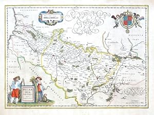
Picardia Regio Belgica
Verlag: Blaeu, Joan and Willem, 1634
Karte
Kein Einband. Zustand: Gut bis sehr gut. Picardy. "Picardia Regio Belgica, Auctore Ioanne Surhonio". Orig. copper-engraving after J. Surhon's map of the region. G. and J. Blaeu, Amsterdam, 1634. With fig. title cartouche, ornament. cartouche with the scale of map and a great coat-of-arms with 2 cherubs. 38,5:53,5 cm (15 1/4 x 21 inch.). Koeman II, map 4100:2A, ed. 2:231 (1641-42 German). - A map of Picardy, a historical territory in the north of France, with the city of Amiens in the centre.
-
Prima Pars Brabantiae Cuius Caput Lovanium.
Verlag: c.1640, Amsterdam, 1640
Anbieter: Alexandre Antique Prints, Maps & Books, Toronto, ON, Kanada
Bewertung:

Karte
Latin text on verso.Map showing the vicinity of Leuven, Belgium.With decorative cartouche, numerous coats of arms, scale of miles, and several figures.The map was drawn for Blaeu by Michael Floris van Langren, the mathematician and astronomer to the King of Spain.Willem Janszoon Blaeu (1571-1638) was a Dutch cartographer, atlas maker, and publisher. Along with his son Johannes Blaeu, Willem is considered one of the notable figures of the Netherlandish or Dutch school of cartography during its golden age in the 16th and 17th centuries., Size : 415x522 (mm), 16.34x20.55 (Inches), Original Hand Coloring Good, with restoration and uniform age toning.
-
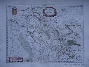
Kleve - "Clivia Ducatus et Ravestein Dominium". Altkolorierte Kupferstich-Karte von Willem Janszoon Blaeu. Bildgröße: 38,5 x 52 cm. Blattgröße: 51 x 61 cm.
Verlag: (Amsterdam, )., 1644
Anbieter: Antiquariat Hans-Jürgen Ketz, Münster, NRW, Deutschland
Bewertung:
Karte
** Großformatige Karte des Niederrheins bzw. vom Herzogtum Kleve. Mit Wappen und Meilenzeiger. Rückseitig Text in Latein. * Stellenweise fleckig. Breitrandig. Insgesamt ordentlich. (SW: Dekorative Graphik - 17. Jahrhundert - Kupferstich - Kupferstichkarte - Westfalen - Ruhrgebiet - Niederrhein).
-
Lieroort [Leerort]. Befestigungsplan mit dem Flußlauf von Ems und Leda. Orig.-Kupferstich.
Verlag: Amsterdam, um 1650., 1650
Karte
ca. 33 x 22 cm, Zustand: Sehr gut. Aus dem Stedenboek der Brüder Blaeu. Einige kl. Flecken, sonst sehr guter Zustand. Lieferung unter Passepartout. /krippe Sprache: Deutsch Gewicht in Gramm: 2100.
-
Ager Parisiensis vulgo L'Isle De France.
Verlag: c.1640, Amsterdam, 1640
Anbieter: Alexandre Antique Prints, Maps & Books, Toronto, ON, Kanada
Bewertung:
Karte
Latin text on verso.Map of the region of Paris.Willem Janszoon Blaeu (1571-1638) was a Dutch cartographer, atlas maker, and publisher. Along with his son Johannes Blaeu, Willem is considered one of the notable figures of the Netherlandish or Dutch school of cartography during its golden age in the 16th and 17th centuries., Size : 382x498 (mm), 15.04x19.61 (Inches), Original Hand Coloring Good, with restoration and uniform age toning.
-
Zustand: -. Altkolorierter Kupferstich. 1644, 50 x 58 cm. Zeigt die Rheinpfalz. Oben rechts und links ausgemalte Titelkartusche und Wappen. Unten rechts Meilenzeiger mit Engel als Träger der bayerischen Fahne. Rückseitige beschriftung in Niederländisch. Schönes Blatt.
-
Perchensis Comitatus. Le Perche Comte - Comitatus Blesensis, Auctore Ioanne Temporio. Blaisois.
Verlag: Blaeu, Amsterdam, 1631
Karte
Kein Einband. Zustand: Sehr gut. Perche [left] und Blois [right]. "Perchensis Comitatus. Le Perche Comte. Comitatus Blesensis, Auctore Ioanne Temporio. Blaisois". Orig. copperplate engraving, W. J. Blaeu, 1631. Orig. old colouring. With 2 ornamental title cartouches. 39:50,5 cm (15 1/4 x 20 inch.). Koeman II. map 4365+4370:2, ed. 2:201 (1640-43 Latin). - Two maps of French regions printed from one plate.
-
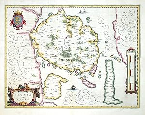
Fionia vulgo Funen
Verlag: Blaeu, Joan, Amserdam, 1640
Funen. "Fionia vulgo Funen". Orig. copperplate engraving, W. J. Blaeu. Published by J. Blaeu in Amsterdam, ca. 1640. Orig. old colouring. With figure title cartouche, ornamental cartouche with the scale of map ("Milliaria Germanica communia"), great coat-of-arms and several ships. 38,5:50 cm (15 1/4 x 19 3/4 inch.). Koeman II, Map 1530:2, Ed. 2:231 (1641-42 German). - A decorativ map of the Danish islan Funen.
-
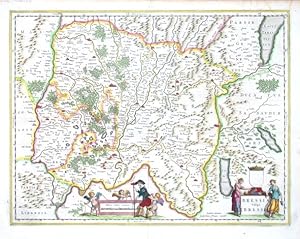
Bressia Vulgo Bresse
Verlag: Blaeu, Willem, Amsterdam, 1640
"Bressia Vulgo Bresse". Orig. copperplate engraving. Published in Amsterdam by W. Blaeu, ca. 1640. Orig. old colouring. With figure title-cartouche with a coat of arms (blank) and another cartouche with the scale of map ("Milliaria Gallica communia"), 3 cherubs and a figure. 38,5:50 cm (15 1/4 x 19 3/4 inch.). Koeman II, map 4810:2A, ed. 2:231 (1641-42 German) - A very decorative map of the Bresse, a region in south-eastern France, centered on the city of Bourg-en-Bresse.
-

Corsica Insula
Verlag: Blaeu, Willem Janszoon, 1635
Karte
Kein Einband. Zustand: Sehr gut. Corsica (France)."Corsica Insula". Orig. copperplate engraving, W. J. Blaeu, 1634. Original outline colouring. With engraved title. 18:24 cm (7 x 9 1/2 inch.) Koeman II, map 7525:2A, ed. 2:101 (1635 Latin) - A map of Corsica. Oriented to the east.
-

Dioecese de Rheims et le pais de Rethel
Verlag: Blaeu, W. a J., Amsterdam, 1640
Reims - Rethel. "Dioecese de Rheims et le pais de Rethel". Orig. copperplate engraving, W. J. Buaeu, 1634, after J. Jubrien's map of the region. Published by W. and J. Blaeu, 1644. Orig. old colouring. With ornamental title-cartouche with two coats-of-arms. 41:52,5 cm. Koeman II, map 4210:2, ed. 2:202-3 (1644-55 Latin) - A map of the city of Reims with its environs.
-
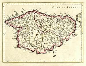
Corsica Insula
Verlag: Blaeu, Amsterdam, 1635
Karte
Kein Einband. Zustand: Sehr gut. Corsica. "Corsica Insula". Orig. copperplate engraving, W. J. Blaeu, 1634. Original old colouring. With engraved title. 18:24 cm (7 x 9 1/2 inch.) Koeman II, map 7525:2A, ed. 2:101 (1635 Latin) - A map of Corsica. Oriented to the East.
-
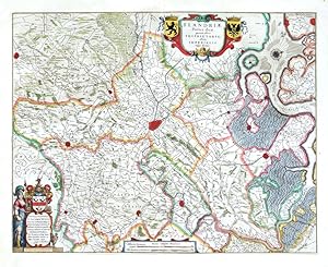
Flandriae Partes duae
Verlag: Willem and Joan Blaeu, Amsterdam, 1634
Karte
Kein Einband. Zustand: Sehr gut. East Flanders. "Flandriae Partes duae, quarum altera Proprietaria, altera Imperialis vulgo dicitur". Orig. copperplate engraving, W. J. Blaeu, 1634. Published in Amsterdam by J. Blaeu, 1640. Orig. old colouring. With ornamental title-cartouche with 2 coats-of-arms, a figure cartouche with dedication (to Jacobus Wiits) and another cot-of-arms and a cartouche with the scale of map ("Huius tabulae Mensurae"). 41,5:52 cm (16 1/4 x 20 1/2 inch.). Koeman II, map 3215:2 (Vlaanderen (Imperial)), ed. 2:201 (1640-43 Latin). - A decorative map of the East Flanders, centered on the city of Gent.
-

Ducatus Limburgum
Verlag: Blaeu, W. - Blaeu, J., Amsterdam, 1634
Limburg. "Ducatus Limburgum". Orig. copperplate engraving, W. J. Blaeu, 1634, after A. Martini's map of the region. Published by J. Blaeu in Amsterdam, 1641. Orig. old colouring. With great ornamental title-cartouche wit a coat-of-arms and 2 cherubs, and a cartouche with the scale of map ("Milliaria Gallica . Germanica) with 2 figures. 38,5:50 cm (15 1/4 x 19 3/4 inch.). Koeman II, map 3170:2, ed. 2:231 (1641-42 German). - A map of the province of Limburg. With the cities of Maastricht, Liege, Limbourg, Huy and others.
-
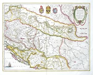
Sclavonia, Croatia, Bosniacum Dalmatiae parte
Verlag: Blaeu, Joan, Amsterdam, 1644
Slovenia, Croatia, Bosnia and Herzegovina. "Sclavonia, Croatia, Bosniacum Dalmatiae parte". Orig. copperplate engraving, W. J. Blaeu after G. Mercator's map of the region. Published in Amsterdam by J. Blaeu, 1644. Orig. old colouring. With ornamental title-cartouche, 3 coats-of-arms and a sailing ship. 38:50 cm (15 x 19 3/4 inch.). Koeman II, map 7601:2A, ed. 2:202-3 (1644-55 Latin). - A map of Slovenia, Croatia, Bosnia and Herzegovina, Dalmatia and a part of Serbia.
-
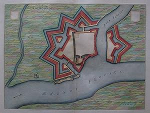
Kein Einband. Zustand: Sehr gut. Es handelt sich hierbei um einen originalen, kolorierten Kupferstichplan der Befestigungsanlagen der Gemeinde Duisburg-Ruhrort von Willem Janszoon Blaeu (1571 - 1638) aus dem Jahr 1649. *** Titel: Roeroordt *** Gebiet bzw. Ort: Duisburg-Ruhrort *** Kartograph: Willem Janszoon Blaeu (1571 - 1638) *** Jahr: 1649 *** Größe des Plattenbereichs: 37 x 50 cm *** Technik: Kupferstich *** Zustand (Perfekt/ Sehr gut/ Gut/ Ordentlich/ Mäßig/ Schlecht): In sehr gutem Erhaltungszustand *** Bemerkungen: Plan der Befestigungsanlagen und der Umgebung - - - International buyers welcome. If you have any questions, please don't hesitate to ask. --- Auf Wunsch stellen wir Ihnen gerne ein kostenfreies Echtheitszertifikat aus --- If you wish, we will gladly provide a certificate of authenticity free of charge ---.
-

Hessen. Stift Hersfeld. Blaeu. Territorium Abbatiae Heresfeldensis - 't Stift Hirßfeldt
Erscheinungsdatum: 1635
Zustand: guter Zustand. Hessen. Stift Hersfeld. Blaeu. Territorium Abbatiae Heresfeldensis - 't Stift Hirßfeldt.1635. Kupferstich, alt koloriert. Landkarte, von Willem Janszoon Blaeu. 38,7 x 50,2 cm (Darstellung), 49 x 60,5 cm (Blatt).Aus: Willem Janszoon Blaeu, Novus Atlas. Das ist Abbildung und Beschreibung von allen Ländern des Erdreichs (Amsterdam: Blaeu 1635). Zeigt Landkarte um Bad Hersfeld mit den Flüssen Fulda, Aula, Geis und Rohrbach. Rückseite mit französischem Text. Bütten leicht verbräunt, stockfleckig und knickspurig. Mittig ausgeprägte Bugfalte. Insgesamt recht gut erhalten.Willem Janszoon Blaeu (1571 Uitgeest/Alkmaar - 1638 Amsterdam). Auch Guilielmus Janssonius Caesius, Guiljelmus Blaeuw, Willem Jansz oder Willems Jans Zoon. Niederländischer Kartograf und Verleger. Lernte 1594-96 Astronomie und Kartografie bei Tycho Brahe. Ließ sich um 1603 in Amsterdam nieder, wo er mit der Herstellung von Erdgloben begann, bald aber auch Land- und Seekarten anfertigte. 1605 erschien seine erste Weltkarte. Erwarb 1629 für seinen ersten Atlas einige Druckplatten von Jodocus Hondius. Wurde 1633 zum Kaartenmaker van de Republiek ernannt. Sein Sohn Joan Blaeu setzte den Betrieb mit weiteren Atlanten fort. Im Jahr 1641/42 erschien als Hauptwerk von Vater und Sohn 'Novus Atlas, Das ist Weltbeschreibung, mit schönen newen außführlichen Land-Taffeln. Rechts unten Aufwendige Titelkartusche mit Wappen, Bischofsinsignien und Putten. Darunter Verlegeradresse Apud Guiljelmum Blaeu. Links unten 2 Meilenzeiger / Maßstab.

![Bild des Verkäufers für Lieroort [Leerort]. Befestigungsplan mit dem Flußlauf von Ems und Leda. Orig.-Kupferstich. zum Verkauf von Antiquariat Hecht](https://pictures.abebooks.com/inventory/md/md30519968837.jpg)