Blaeu johan (41 Ergebnisse)

Sprache: Englisch
Verlag: John Bartholomew, Edinburgh, 1970
Anbieter: K Books Ltd ABA ILAB, York, YORKS, Vereinigtes KönigreichK Books Ltd ABA ILAB
Verkäufer/-in kontaktierenVerkäufer/-in mit 5 SternenZustand: Gebraucht - Gut
EUR 12,12
EUR 22,94 VersandVersand von Vereinigtes Königreich nach USAAnzahl: 1 verfügbar
In den WarenkorbNo Binding. Zustand: Very Good. Reproduction. A reproduction of a map by Johan Blaeu, drawn originally for his Atlas Novus of 1648; there is no date on this reproduction but it is c1970, on good quality paper. It was printed by John Bartholomew & Son of Edinburgh and published jointly with the Royal Scottish Geographical Society…, in colour which is faithful to the contemporary colouring. The map shows the whole of Yorkshire, divided into Wapentakes, showing the churches and the parks of great houses. This map is too large to mount, so will be posted rolled in a tube. Blaeu (illustrator).
CHESHIRE - Colour Reproduction of a Map Originally Drawn By Johan Blaeu in 1648
CHESHIRE - Colour Reproduction of a Map Originally Drawn By Johan Blaeu in 1648
Sprache: Englisch
Verlag: John Bartholomew, Edinburgh, 1970
Anbieter: K Books Ltd ABA ILAB, York, YORKS, Vereinigtes KönigreichK Books Ltd ABA ILAB
Verkäufer/-in kontaktierenVerkäufer/-in mit 5 SternenZustand: Gebraucht - Gut
EUR 24,24
EUR 22,94 VersandVersand von Vereinigtes Königreich nach USAAnzahl: 1 verfügbar
In den WarenkorbNo Binding. Zustand: Very Good. Reproduction. A reproduction of a map by Johan Blaeu, drawn originally for his Atlas Novus of 1648 reprinted in 1662; there is no date on this reproduction but it is c1970, on good quality paper. It was printed by John Bartholomew & Son of Edinburgh and published jointly with the Royal Scottish Ge…ographical Society, in colour which is faithful to the contemporary colouring. The title of the map is "Cestria Comitatus Palatinus" and it is ornamented with coats of arms. This map is too large to post mounted and so will be posted rolled in a tube. Blaeu (illustrator).
MULA INSULA - the Yle of Mul - THE ISLAND OF MULL, SCOTLAND - Reproduction of a Map Originally Drawn By Johan Blaeu in 1654
MULA INSULA - the Yle of Mul - THE ISLAND OF MULL, SCOTLAND - Reproduction of a Map Originally Drawn By Johan Blaeu in 1654
Sprache: Englisch
Verlag: John Bartholomew, Edinburgh, 1970
Anbieter: K Books Ltd ABA ILAB, York, YORKS, Vereinigtes KönigreichK Books Ltd ABA ILAB
Verkäufer/-in kontaktierenVerkäufer/-in mit 5 SternenZustand: Gebraucht - Gut
EUR 24,24
EUR 22,94 VersandVersand von Vereinigtes Königreich nach USAAnzahl: 1 verfügbar
In den WarenkorbNo Binding. Zustand: Very Good. Reproduction. A reproduction of a map by Johan Blaeu, drawn originally for his Atlas Novus of 1654, reprinted in 1662; there is no date on this reproduction but it is c1970, on good quality paper. It was printed by John Bartholomew & Son of Edinburgh and published jointly with the Royal Scottish G…eographical Society, in colour which is faithful to the contemporary colouring. The map shows the Island of Mull including Iona, Tiree, Coll, Lismore & part of Jura. This map is too large to mount, so will be posted rolled in a tube. Blaeu (illustrator).
PRAEFECTURA RENFROANA VULGO DICTA BARONIA - the Baronie of Renfrow - MAP OF PART OF RENFREWSHIRE, SCOTLAND - Reproduction of a Map Originally Drawn By Johan Blaeu in 1654
PRAEFECTURA RENFROANA VULGO DICTA BARONIA - the Baronie of Renfrow - MAP OF PART OF RENFREWSHIRE, SCOTLAND - Reproduction of a Map Originally Drawn By Johan Blaeu in 1654
Sprache: Englisch
Verlag: John Bartholomew, Edinburgh, 1970
Anbieter: K Books Ltd ABA ILAB, York, YORKS, Vereinigtes KönigreichK Books Ltd ABA ILAB
Verkäufer/-in kontaktierenVerkäufer/-in mit 5 SternenZustand: Gebraucht - Gut
EUR 24,24
EUR 22,94 VersandVersand von Vereinigtes Königreich nach USAAnzahl: 1 verfügbar
In den WarenkorbNo Binding. Zustand: Very Good. Reproduction. A reproduction of a map by Johan Blaeu, drawn originally for his Atlas Novus of 1654, reprinted in 1662; there is no date on this reproduction but it is c1970, on good quality paper. It was printed by John Bartholomew & Son of Edinburgh and published jointly with the Royal Scottish G…eographical Society, in colour which is faithful to the contemporary colouring. The map shows the Firth of Clyde as far as Glasgow, in detail as far west as Gourock with an indication of the port of Largs, as far sough as the Loch of Kilbirnie. This map is too large to mount, so will be posted rolled in a tube. Blaeu (illustrator).

- Hardcover
Anbieter: Müller & Gräff e.K., Stuttgart, DeutschlandMüller & Gräff e.K.
Verkäufer/-in kontaktierenVerkäufer/-in mit 5 SternenZustand: Gebraucht
EUR 20,00
EUR 45,00 VersandVersand von Deutschland nach USAAnzahl: 1 verfügbar
Gr.4°. 224 S. Mit 100 farb. Karten. Original-Pappband mit Schutzumschlag. Schutzumschlag abgegriffen. Gewicht (Gramm): 2800.
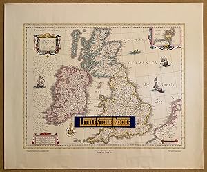
Magnae Britanniae et Hiberniae Tabula (Great Britain and Ireland Map) Theatrum Orbis Terrarum, 1635.
Verlag: Published Jointly with the Royal Geographical Society | Printed by John Bartholomew & Son Ltd., Edinburgh.
Anbieter: Little Stour Books PBFA Member, Canterbury, Vereinigtes KönigreichLittle Stour Books PBFA Member
Verkäufer/-in kontaktierenVerkäufer/-in mit 5 SternenVerbandsmitglied: PBFA
Zustand: Gebraucht - Gut
EUR 24,24
EUR 35,30 VersandVersand von Vereinigtes Königreich nach USAAnzahl: 1 verfügbar
In den WarenkorbZustand: Very Good. Coloured facsimile reprint of the original authentic map of Great Britain and Ireland on fine quality water-marked cream paper. 20'' x 24''. In Very Good condition with some crease lines along the bottom edge. Sent rolled in a tube. Member of the P.B.F.A. CARTOGRAPHY, MAPS, PLANS.
Verlag: Published Jointly with the Royal Geographical Society | Printed by John Bartholomew & Son Ltd., Edinburgh.
Anbieter: Little Stour Books PBFA Member, Canterbury, Vereinigtes KönigreichLittle Stour Books PBFA Member
Verkäufer/-in kontaktierenVerkäufer/-in mit 5 SternenVerbandsmitglied: PBFA
Zustand: Gebraucht - Sehr gut
EUR 24,24
EUR 35,30 VersandVersand von Vereinigtes Königreich nach USAAnzahl: 1 verfügbar
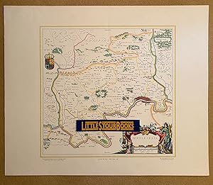
In den WarenkorbZustand: Fine. Coloured facsimile reprint of the original authentic map of Middlesex. 19½'' x 24''. In Fine condition. Sent rolled in a tube. Member of the P.B.F.A. MIDDLESEX (Middleseaxan).

Verlag: Published Jointly with the Royal Geographical Society | Printed by John Bartholomew & Son Ltd., Edinburgh.
Anbieter: Little Stour Books PBFA Member, Canterbury, Vereinigtes KönigreichLittle Stour Books PBFA Member
Verkäufer/-in kontaktierenVerkäufer/-in mit 5 SternenVerbandsmitglied: PBFA
Zustand: Gebraucht - Sehr gut
EUR 24,24
EUR 35,30 VersandVersand von Vereinigtes Königreich nach USAAnzahl: 1 verfügbar
In den WarenkorbZustand: Fine. Coloured facsimile reprint of the original authentic map of Hertfordshire. 19½'' x 24''. In Fine condition. Sent rolled in a tube. Member of the P.B.F.A. HERTFORDSHIRE.
 Weitere Bilder
Verlag: Theatrum Orbis Terrarum Ltd, Amsterdam, 1967
- Hardcover
- Erstausgabe
Anbieter: George Jeffery Books, HERTFORDSHIRE, Vereinigtes KönigreichGeorge Jeffery Books
Verkäufer/-in kontaktierenVerkäufer/-in mit 5 SternenVerbandsmitglied: PBFA
Zustand: Gebraucht - Gut
EUR 363,56
EUR 29,41 VersandVersand von Vereinigtes Königreich nach USAAnzahl: 1 verfügbar
In den WarenkorbVellum. Zustand: Very Good. Limited Edition. Volume 5 of a 12 volume set. Limited to 1000 copies. Book measures 55x34.cm. 321pp, double page maps throughout. Bound in original publishers faux vellum, ornate gilt tooling. Vellum bumped, some dust,dirt marking. Generally binding in good clean firm condition. Internally, pages clea…n throughout. A good solid copy. Size: Filio.
Verlag: Theatrvm Orbis Terrarvm, 1967
- Hardcover
Anbieter: Chapter 1, Johannesburg, GAU, SüdafrikaChapter 1
Verkäufer/-in kontaktierenVerkäufer/-in mit 5 SternenZustand: Gebraucht - Gut
EUR 2.481,23
EUR 25,00 VersandVersand von Südafrika nach USAAnzahl: 1 verfügbar
In den WarenkorbHardcover. Zustand: Very Good. No Jacket. A complete set of 12 volumes, each bound in imitation vellum. Limited edition number 163 of 1100. French text. The boards are a touch worn with the corners a little scuffed, the spine ends a bit creased, but they remain strong and sturdy. Internally neat and fine. The bindings are secure…. A large and very heavy set (a packed weight of around 70kg), but handsome indeed! JK. Our orders are shipped using tracked courier delivery services.
 Weitere Bilder
Verlag: Loreto
Anbieter: Sergio Trippini, Gavirate, VA, ItalienSergio Trippini
Verkäufer/-in kontaktierenVerkäufer/-in mit 5 SternenZustand: Gebraucht
EUR 100,00
EUR 48,00 VersandVersand von Italien nach USAAnzahl: 1 verfügbar
In den Warenkorb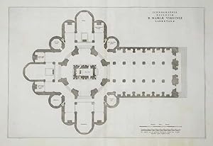 Weitere Bilder
Verlag: Loreto
Anbieter: Sergio Trippini, Gavirate, VA, ItalienSergio Trippini
Verkäufer/-in kontaktierenVerkäufer/-in mit 5 SternenZustand: Gebraucht
EUR 100,00
EUR 48,00 VersandVersand von Italien nach USAAnzahl: 1 verfügbar
In den WarenkorbPianta della chiesa, dedicata alla Vergine Maria.
 Weitere Bilder
Verlag: Tivoli
Anbieter: Sergio Trippini, Gavirate, VA, ItalienSergio Trippini
Verkäufer/-in kontaktierenVerkäufer/-in mit 5 SternenZustand: Gebraucht
EUR 150,00
EUR 48,00 VersandVersand von Italien nach USAAnzahl: 1 verfügbar
In den WarenkorbVeduta panoramica con le grandi cascate, molto decorativa.
 Weitere Bilder
Verlag: Ostia
Anbieter: Sergio Trippini, Gavirate, VA, ItalienSergio Trippini
Verkäufer/-in kontaktierenVerkäufer/-in mit 5 SternenZustand: Gebraucht
EUR 200,00
EUR 48,00 VersandVersand von Italien nach USAAnzahl: 1 verfügbar
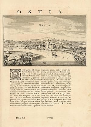
In den WarenkorbVeduta della città lungo il fiume Tevere, percorso da imbarcazioni. Testo al Verso.
 Weitere Bilder
Verlag: Nettuno
Anbieter: Sergio Trippini, Gavirate, VA, ItalienSergio Trippini
Verkäufer/-in kontaktierenVerkäufer/-in mit 5 SternenZustand: Gebraucht
EUR 200,00
EUR 48,00 VersandVersand von Italien nach USAAnzahl: 1 verfügbar
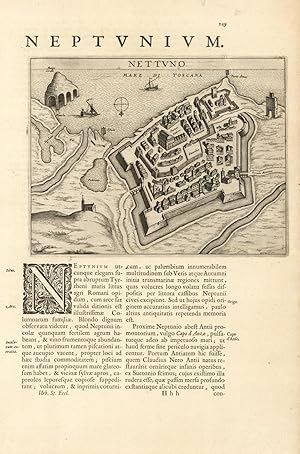
In den WarenkorbPianta planimetrica prospettica della città.
 Weitere Bilder
Verlag: Bologna
Anbieter: Sergio Trippini, Gavirate, VA, ItalienSergio Trippini
Verkäufer/-in kontaktierenVerkäufer/-in mit 5 SternenZustand: Gebraucht
EUR 250,00
EUR 48,00 VersandVersand von Italien nach USAAnzahl: 1 verfügbar
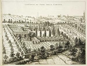
In den WarenkorbVeduta del convento della Certosa.
 Weitere Bilder
Verlag: Bologna
Anbieter: Sergio Trippini, Gavirate, VA, ItalienSergio Trippini
Verkäufer/-in kontaktierenVerkäufer/-in mit 5 SternenZustand: Gebraucht
EUR 250,00
EUR 48,00 VersandVersand von Italien nach USAAnzahl: 1 verfügbar
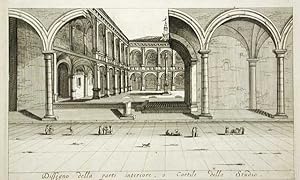
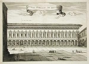
In den WarenkorbVedute dei portici dello studio publico.
 Weitere Bilder
Verlag: Bologna
Anbieter: Sergio Trippini, Gavirate, VA, ItalienSergio Trippini
Verkäufer/-in kontaktierenVerkäufer/-in mit 5 SternenZustand: Gebraucht
EUR 350,00
EUR 48,00 VersandVersand von Italien nach USAAnzahl: 1 verfügbar
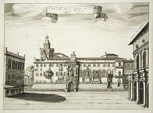
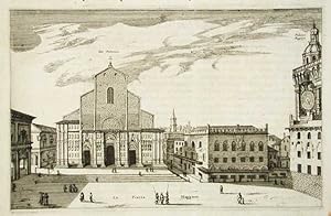
In den WarenkorbVeduta di Piazza Maggiore.
 Weitere Bilder
Verlag: Bologna
Anbieter: Sergio Trippini, Gavirate, VA, ItalienSergio Trippini
Verkäufer/-in kontaktierenVerkäufer/-in mit 5 SternenZustand: Gebraucht
EUR 350,00
EUR 48,00 VersandVersand von Italien nach USAAnzahl: 1 verfügbar
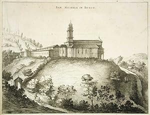
In den WarenkorbVeduta dell chiesa di San Michele in Bosco.
 Weitere Bilder
Verlag: Bologna
Anbieter: Sergio Trippini, Gavirate, VA, ItalienSergio Trippini
Verkäufer/-in kontaktierenVerkäufer/-in mit 5 SternenZustand: Gebraucht
EUR 350,00
EUR 48,00 VersandVersand von Italien nach USAAnzahl: 1 verfügbar
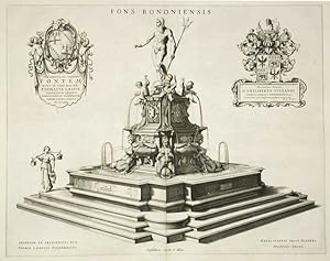
In den WarenkorbStatua del Nettuno.
 Weitere Bilder
Verlag: Bologna
Anbieter: Sergio Trippini, Gavirate, VA, ItalienSergio Trippini
Verkäufer/-in kontaktierenVerkäufer/-in mit 5 SternenZustand: Gebraucht
EUR 350,00
EUR 48,00 VersandVersand von Italien nach USAAnzahl: 1 verfügbar
In den WarenkorbVeduta di Piazza Maggiore.
 Weitere Bilder
Verlag: Bologna
Anbieter: Sergio Trippini, Gavirate, VA, ItalienSergio Trippini
Verkäufer/-in kontaktierenVerkäufer/-in mit 5 SternenZustand: Gebraucht
EUR 350,00
EUR 48,00 VersandVersand von Italien nach USAAnzahl: 1 verfügbar
In den WarenkorbVeduta della chiesa di San Petronio e piazza Maggiore.
 Weitere Bilder
Verlag: Bologna
Anbieter: Sergio Trippini, Gavirate, VA, ItalienSergio Trippini
Verkäufer/-in kontaktierenVerkäufer/-in mit 5 SternenZustand: Gebraucht
EUR 350,00
EUR 48,00 VersandVersand von Italien nach USAAnzahl: 1 verfügbar
In den WarenkorbVeduta dello Publico in Bologna e piazza antistante.
 Weitere Bilder
Verlag: Bologna
Anbieter: Sergio Trippini, Gavirate, VA, ItalienSergio Trippini
Verkäufer/-in kontaktierenVerkäufer/-in mit 5 SternenZustand: Gebraucht
EUR 400,00
EUR 48,00 VersandVersand von Italien nach USAAnzahl: 1 verfügbar
In den WarenkorbClassica veduta delle due torri.
 Weitere Bilder
Verlag: Avignone - Francia
Anbieter: Sergio Trippini, Gavirate, VA, ItalienSergio Trippini
Verkäufer/-in kontaktierenVerkäufer/-in mit 5 SternenZustand: Gebraucht
EUR 400,00
EUR 48,00 VersandVersand von Italien nach USAAnzahl: 1 verfügbar
In den WarenkorbPianta planimetrica prospettica della città.
 Weitere Bilder
Verlag: Palestrina
Anbieter: Sergio Trippini, Gavirate, VA, ItalienSergio Trippini
Verkäufer/-in kontaktierenVerkäufer/-in mit 5 SternenZustand: Gebraucht
EUR 450,00
EUR 48,00 VersandVersand von Italien nach USAAnzahl: 1 verfügbar
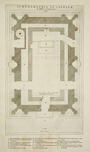
In den WarenkorbPianta planimetrica prospettica del Tempio della Fortuna. In alto titolo entro festone sorretto da putti, in calce rimandi da A a T. Testo al verso.
 Weitere Bilder
Verlag: Tivoli
Anbieter: Sergio Trippini, Gavirate, VA, ItalienSergio Trippini
Verkäufer/-in kontaktierenVerkäufer/-in mit 5 SternenZustand: Gebraucht
EUR 500,00
EUR 48,00 VersandVersand von Italien nach USAAnzahl: 1 verfügbar
In den WarenkorbBella veduta della città.Tratta dall'opera "Theatrum Civitatum / et /Admirandorum / Italae." stampata ad Amsterdam nel 1663. Testo al verso.
 Weitere Bilder
Verlag: WILLEM JANSZOON BLAEU et JOHAN BLAEU, 1640
- Erstausgabe
- Karte
Anbieter: Librairie Maxime Katz, Villeurbanne, FR, FrankreichLibrairie Maxime Katz
Verkäufer/-in kontaktierenVerkäufer/-in mit 2 SternenZustand: Gebraucht - Gut bis sehr gut
EUR 550,00
EUR 36,00 VersandVersand von Frankreich nach USAAnzahl: 1 verfügbar
In den WarenkorbPas de couverture. Zustand: Bon. Edition originale. Blaeu VIRGINAE PARTIS AUSTRALIS ET FLORIDAE, PARTIS ORIENTALIS, INTERJACENTIUMQ, REGIONUM NOVA DESCRIPTIO WILLEM JANSZOON BLAEU et JOHAN BLAEU A AMSTERDAM Circa 1640 Gravure sur cuivre Papier pur chiffon Coloris d'époque 60 x 50 centimètres (format hors tout) Nombreuses rousseu…rs et fragilité du papier avec petits manques (voir les photos) GRAVURE ORIGINALE DE 1640.
 Weitere Bilder
Verlag: Tivoli
Anbieter: Sergio Trippini, Gavirate, VA, ItalienSergio Trippini
Verkäufer/-in kontaktierenVerkäufer/-in mit 5 SternenZustand: Gebraucht
EUR 600,00
EUR 48,00 VersandVersand von Italien nach USAAnzahl: 1 verfügbar
In den WarenkorbVeduta generale della città.
 Weitere Bilder
Verlag: Velletri
Anbieter: Sergio Trippini, Gavirate, VA, ItalienSergio Trippini
Verkäufer/-in kontaktierenVerkäufer/-in mit 5 SternenZustand: Gebraucht
EUR 700,00
EUR 48,00 VersandVersand von Italien nach USAAnzahl: 1 verfügbar
In den WarenkorbPianta planimetrico prospettica della città, In basso rimandi da 1 a 40. Testo al verso.


