
Gesamtpreis (1 Artikel Artikel):
Versandziel:

blackmore nathaniel (2 Ergebnisse)
Direkt zu den wichtigsten Suchergebnissen
Suchfilter
Produktart
- Alle Product Types
- Bücher (2)
- Magazine & Zeitschriften (Keine weiteren Ergebnisse entsprechen dieser Verfeinerung)
- Comics (Keine weiteren Ergebnisse entsprechen dieser Verfeinerung)
- Noten (Keine weiteren Ergebnisse entsprechen dieser Verfeinerung)
- Kunst, Grafik & Poster (Keine weiteren Ergebnisse entsprechen dieser Verfeinerung)
- Fotografien (Keine weiteren Ergebnisse entsprechen dieser Verfeinerung)
- Karten (Keine weiteren Ergebnisse entsprechen dieser Verfeinerung)
- Manuskripte & Papierantiquitäten (Keine weiteren Ergebnisse entsprechen dieser Verfeinerung)
Zustand Mehr dazu
- Neu (Keine weiteren Ergebnisse entsprechen dieser Verfeinerung)
- Wie Neu, Sehr Gut oder Gut Bis Sehr Gut (Keine weiteren Ergebnisse entsprechen dieser Verfeinerung)
- Gut oder Befriedigend (2)
- Ausreichend oder Schlecht (Keine weiteren Ergebnisse entsprechen dieser Verfeinerung)
- Wie beschrieben (Keine weiteren Ergebnisse entsprechen dieser Verfeinerung)
Einband
- alle Einbände
- Hardcover (1)
- Softcover (Keine weiteren Ergebnisse entsprechen dieser Verfeinerung)
Weitere Eigenschaften
- Erstausgabe (Keine weiteren Ergebnisse entsprechen dieser Verfeinerung)
- Signiert (Keine weiteren Ergebnisse entsprechen dieser Verfeinerung)
- Schutzumschlag (Keine weiteren Ergebnisse entsprechen dieser Verfeinerung)
- Angebotsfoto (1)
Sprache (1)
Preis
- Beliebiger Preis
- Weniger als EUR 20 (Keine weiteren Ergebnisse entsprechen dieser Verfeinerung)
- EUR 20 bis EUR 45
- Mehr als EUR 45
Gratisversand
- Kostenloser Versand nach USA (Keine weiteren Ergebnisse entsprechen dieser Verfeinerung)
Land des Verkäufers
Verkäuferbewertung
-

The Poetical Works of Nathaniel Cotton [bound with] Select Poems of Sir Richard Blackmore.
Verlag: London: printed at the Stanhope Press by Whittingham and Rowland, and published by Suttaby, Evance and Fox, 1812., 1812
Anbieter: Cornell Books Limited, Tewkesbury, Vereinigtes Königreich
Verbandsmitglied: PBFA
Verkäuferbewertung 5 von 5 Sternen

EUR 35,66
EUR 17,25 Versand
Versand von Vereinigtes Königreich nach USAAnzahl: 1 verfügbar
In den WarenkorbZustand: Good. Two works bound together (hardback). 16mo (13cm by 8cm), 159pp; 176pp. Two engraved portrait frontispieces. Bound in full red morocco, gilt titling and tooling to the spine, gilt tooling to the boards, all edgs gilt. This book was formerly in an institutional library, with a bookplate to the front pastedown and one library stamp, but the book is nonetheless in good to very good condition overall.
-
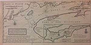
A Description of the Bay of Fundy Shewing ye Coast, Islands, Harbours, Creeks, Coves, Rocks, Sholes, Soundings & Anchorings &c
Verlag: Thomas Bowles, London
Anbieter: Argosy Book Store, ABAA, ILAB, New York, NY, USA
Verkäuferbewertung 5 von 5 Sternen
unbound. Zustand: very good(+). Map. Engraving with original hand coloring. 9" x 18". Shows verso repair along one of two original fold lines, otherwise in very good condition. Beautiful 1736 chart of the Bay. Includes notes on soundings, tides and currents, and an inset of The Harbour of Annapolis Royal. King James I of England named the same territory New Scotland (or Nova Scotia, as it was called in its Latin charter) and granted the land to the Scottish colonizer Sir William Alexander. In the 1620s, the Scots established two settlements, but both were unsuccessful. The Bay of Fundy is the worlds highest tide. Herman Moll (c. 1654-1732) settled in London in the 1670's where he worked as an engraver for Moses Pitt. By the turn of the century, Moll became the foremost map publisher in England, where he produced Atlases and maps. As an engraver, cartographer, mapseller and globemaker he appealed to the public with his unusual views and vignettes. As the demand for his work was sustained, he issued many revised editions of his work.
