
Gesamtpreis (1 Artikel Artikel):
Versandziel:

bergelin (11 Ergebnisse)
Direkt zu den wichtigsten Suchergebnissen
Suchfilter
Produktart
- Alle Product Types
- Bücher (6)
- Magazine & Zeitschriften (Keine weiteren Ergebnisse entsprechen dieser Verfeinerung)
- Comics (Keine weiteren Ergebnisse entsprechen dieser Verfeinerung)
- Noten (Keine weiteren Ergebnisse entsprechen dieser Verfeinerung)
- Kunst, Grafik & Poster (1)
- Fotografien (Keine weiteren Ergebnisse entsprechen dieser Verfeinerung)
- Karten (3)
- Manuskripte & Papierantiquitäten (1)
Zustand Mehr dazu
- Neu (Keine weiteren Ergebnisse entsprechen dieser Verfeinerung)
- Wie Neu, Sehr Gut oder Gut Bis Sehr Gut (3)
- Gut oder Befriedigend (1)
- Ausreichend oder Schlecht (Keine weiteren Ergebnisse entsprechen dieser Verfeinerung)
- Wie beschrieben (7)
Einband
- alle Einbände
- Hardcover (2)
- Softcover (Keine weiteren Ergebnisse entsprechen dieser Verfeinerung)
Weitere Eigenschaften
- Erstausgabe (1)
- Signiert (2)
- Schutzumschlag (Keine weiteren Ergebnisse entsprechen dieser Verfeinerung)
- Angebotsfoto (7)
Sprache (1)
Gratisversand
- Kostenloser Versand nach USA (Keine weiteren Ergebnisse entsprechen dieser Verfeinerung)
Land des Verkäufers
Verkäuferbewertung
-

relié. Zustand: Bon état. Sans lieu, ni date, environ 1950. In-4 cartonné, reliure spirale, 25 pages environ. Imprimé et crée par Draeger, Bergelin géographe.Bords frottés ŕ 3 endroits, sinon bel exemplaire. Livres.
-
Göteborgs försvar 1930.
Anbieter: Antiquaria Bok & Bildantikvariat AB, Göteborg, Schweden
Verkäuferbewertung 5 von 5 Sternen

Wald. Zachrissons Boktryckeri, Göteborg 1930. 96,(16) s. Illustrerad. Trĺdhäftad. Litet nagg i ytterkant pĺ bakre del av omslaget. 24 x 16,5 cm.*Ur innehĺllet bl.a. Hans Georg Mörner av Mĺns Mannerfelt; Frĺn kriget mot Norge 1808-1809 av Carl A. Tiselius; Om förbindelserna till Göteborg och deras politiska, militära och ekonomiska betydelse. En historisk-geografisk studie av M. M. [#\116619].
-
Carte de la Mer Baltique et des Pays Scandinaves.
Verlag: LECONTE A.
Karte
Pas de couverture. Zustand: bon. RO80010824: Non daté. In-Plano. En feuillets. Bon état, Couv. convenable, Dos satisfaisant, Intérieur frais. Carte dépliante en couleurs, de 100/75 cm, hors-texte. Pas de plats de couverture. . . . Classification Dewey : 912-Atlas, cartes et plans.
-
GRAY. Reflets de son histoire. Saint-Georges-de-Luzençon : Maury ; Gray : Société des amis du Musée et de la Bibliothčque, 1991.
Anbieter: Mesnard - Comptoir du Livre Ancien, Ruelle-sur-Touvre, Frankreich
Verkäuferbewertung 4 von 5 Sternen

Erstausgabe Signiert
1 volume in-4° relié plein syvertex marron illustré, 229 p., illustrations. Envois autographes signés des auteurs et illustrateurs du maire etc. Trčs bon état. Un des 2700 exemplaires de l'édition originale.
-

CARTE DE BELGIQUE - HOLLANDE.
Verlag: A. LECONTE
Karte
Pas de couverture. Zustand: bon. R240027501: NON DATE. In-Folio. En feuillets. Etat d'usage, Couv. légčrement passée, Dos satisfaisant, Intérieur acceptable. Carte dépliante illustrée en couleurs de 75 x 110 cm ŕ l'échelle 1/500.000e. Manques en bordure de la carte, quelques fentes et trous. . . . Classification Dewey : 912-Atlas, cartes et plans.
-
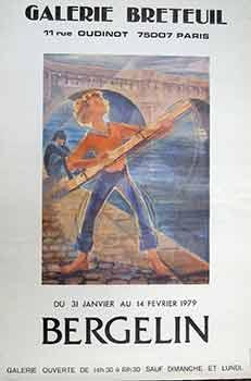
Bergelin : Du 31 Janvier au 14 Fevrier 1979. (Poster).
Verlag: Paris: Galerie Breteuil., 1979
Anbieter: Wittenborn Art Books, San Francisco, CA, USA
Verkäuferbewertung 5 von 5 Sternen
Manuskript / Papierantiquität
Zustand: Good. Large format color print poster 24" x 16". Good. Minor signs of handling. Wear along left edge. Half inch tear on top right corner. Small chip on top edge. Some water damage on verso, not affecting image. Extremely Scarce.
-
1) Carte routičre ZYMA - Suisse. BERGELIN, L. (carthographe, Paris): La Suisse divisée. en 3 cartes routičres dépl. ( GE / ZH / GR. Draeger - Imp. Paris) ens dans l?enveloppe Impr.: ?Cartes Zyma, modčles déposées, Nyon?. 2) Strassenkarte der Schweiz = Carte routičre s.d. ca. 1930. / ENS. avec: Kinstreisen in der Schweiz. 30 n.n. Bl. + Ausf. Verkehrskarte d. Schweiz. 19393) UBS Werbung Postkarte. Otto M. Müller Touristenkarte d. Schweiz.4) T.C.S. Schweizer-Reise mit Verkehrs-Signalen. Sign. E. Tschudi. Ill. 2 S. Lepéorello mit farb. Zeichnungen u. Strassensignale5) Reisekarte der Schweiz. (Schweiz. Bundesbahnen). 1929. 6 S. Text mit 6 fotogr. Abb. - Zh, Orell Füssli, Orig.-Umschlasg mit Abb.
Verlag: 1930 - 1940, 1940
Anbieter: Harteveld Rare Books Ltd., Marly, Schweiz
Verkäuferbewertung 4 von 5 Sternen
in-8vo, Konvolut Tourisme - Schweizerkarten zus., ill. OU. Please notify before visiting to see a book. Prices are excl. VAT/TVA (only Switzerland) & postage.
-

ORIGINAL "GALERIE DU XVIe" POSTER
Verlag: Paris, 1993
Anbieter: Second Story Books, ABAA, Rockville, MD, USA
Verkäuferbewertung 4 von 5 Sternen
Kunst / Grafik / Poster
Original poster in metal frame measuring 16.25 in. x 25.5 in. Poster not examined out of frame. Condition is Very Good with light age toning. AP Consignment. Shelved in Rockville Room B [This is an oversized item. Additional postage necessary for expedited and international orders. Economy International shipping unavailable due to size/weight restrictions. For international and expedited customers, please inquire for rates]. 1381087. Special Collections - Upstairs.
-

Qvartalsskrift för Praktisk Landthushĺllning. Första - Andra Ĺrgĺngen. 1862-63.
Anbieter: Antiquaria Bok & Bildantikvariat AB, Göteborg, Schweden
Verkäuferbewertung 5 von 5 Sternen
Första Ĺrgĺngen. 1862. Med 4 planscher och 9 i texten intryckta träsnitt. Andra Ĺrgĺngen. 1863. Med 4 planscher och 7 i texten intryckta träsnitt. Stockholm, tryckt hos Isaac Marcus, 1862. Stockholm, Huldberg & Komp:s Boktryckeri, 1863-64. 8:o. 252,(4); 192,(2),193-254,(2) s. Samtida halvklotband med rödfärgade snitt. Blekt rygg. *Allt som utkom. Titelblad och register till Första ĺrgĺngen bundna i sluttet av denna. Deltitelblad till Fjärde häftet andra ĺrgĺngen bundet mellan sidan 192 och 193. Saknar huvudtitelblad. Innehĺller även nĺgon artikel om björnjakt och om fĺglar.[#\100569].
-

Tidskrift för svenska landtbruket och dess binäringar. Första - Nionde Ĺrgĺngen.
Anbieter: Antiquaria Bok & Bildantikvariat AB, Göteborg, Schweden
Verkäuferbewertung 5 von 5 Sternen
Stockholm i Tidskriftens expedition 1855-1863. 4:o. 9 vol. Första ĺrgĺngen 1855; Med 18 plancher och 66 träsnitt. (4),380 s. + 18 litografiska planscher, varav tvĺ i färg. Andra ĺrgĺngen 1856; Med 18 pl. och 60 träsn. (6),378 s. + 4 s. bihang + 18 pl. varav en i färg. Tredje ĺrgĺngen 1857; Med 14 pl. och 50 träsn. (6),380 s. + 48 s. bihang + 14 pl. Fjärde ĺrgĺngen 1858; Med 11 pl. och 43 träsn. (6),474 s. + 11 pl. + 8 s. bihang (Förteckning öfver frukt- och park-träd samt bär- och blomster-buskar, törnrosor och perenna växter, m. m. hos K. C. Thorman, Handelsträdgĺrdsmästare.) Femte ĺrgĺngen 1859; Med 120 träsnitt. (6),282,xcv,(1) s. Sjette ĺrgĺngen 1860; Med 12 pl. och 34 träsn. (6),378,xii s. + 12 pl. Sjunde ĺrgĺngen 1861; Med 12 pl. och 30 träsn. (6),378 s. + 12 pl. Ĺttonde ĺrgĺngen 1862; Med 2 portr., 12 pl. och 68 träsn. (6),378 s. + 12 pl. och tvĺ litograferade porträtt (Edvard Nonnen resp. Johan Theophil Nathhorst). Nionde ĺrgĺngen 1863; (2),378,(4) s. + 12 pl. varav en i färg. Vackra samtida halvskinnband i kalv med rikt guldornerade ryggar. Gröna ryggtiteletiketter. Marmorerade pärmpapper av skiftande sort. Mĺnga av planscherna utvikvbara, avbildar bl.a. byggnadsverk, boskapsdjur och lantbruksmaskiner. Planscherna i andra ĺrgĺngen nĺgot lagerfläckade i yttermarginalen. Tidningsstämplar i nedre hörn. Titeletiketten till tredje och sjunde ĺrgĺngen med en liten mista i kanten. Nĺgot nötta pärmpapper och pärmhörn. 26 x 19 cm. 9 volymer. *Ytterligare en ĺrgĺng utkom. Häftesomslagen medbundna sist i varje ĺrgĺng. I slutet finns även medbundet tidningsnotiser och i tredje ĺrgĺngen en förordning samt ett ettbladstryck; Winter-Foder-Ordning för Kor. Stockholm: Henrik And. Nordström, 1832. 2. uppl. 41 x 30 cm. Med en reva i vikningen.[#\1053].
-

La Guerre d'Hitler. Front de Mer.
Erscheinungsdatum: 1940
Anbieter: Geographicus Rare Antique Maps, Brooklyn, NY, USA
Verbandsmitglied: ABAA ESA ILAB
Verkäuferbewertung 4 von 5 Sternen
Karte Signiert
Good. Wear along original fold lines. Verso repairs to fold separations. Areas of infill at several fold intersections. Size 42 x 33 Inches. This is a 1940 Bergelin propaganda map of the British Isles, northern France, and the North Sea at the beginning of World War II (1939 - 1945). The map details the critical effort to keep British and continental shipping lanes and supply lines open. Since this broadside is French, published in Pairs, and anti-German, it must predate the May 1940 German invasion of France. Decoding the Map Focusing on the British Isles and the North Sea, orange highlights industrial areas, iron mines, coal regions, oil regions, and oil refineries in Britain, northern France, Belgium, and western Germany. Purple lines trace shipping routes between Britain and Germany. Orange circles mark the region's principal ports. Wartime Propaganda Text above and below describes international treaties Germany signed but no longer recognized. The blue text along the top is a treaty stipulating that Germany would not deploy undersea mines without notifying shipping companies. The orange text describes how the Reich used such mines without notice. The blue text along the bottom references the Treaty of London on August 22, 1930, guaranteeing that no merchant ship would be sunk without first ensuring the safety of all passengers and crew. Hitler had pulled out of the treaty in August 1938. This time, the orange text described how, out of respect for international law, a British submarine did not sink the German ocean liner 'Bremen' in the North Sea. Historians postulate that this action may have delayed Germany's decision to unleash unrestricted submarine warfare in the Atlantic, thus delaying the critical Battle of the Atlantic. The Battle of the Atlantic Winston Churchill, the British Prime Minister during World War II, claimed that the only part of the war that ever truly frightened him was the 'U-boat peril'. As the war in continental Europe raged, Britain was fighting for its very survival in the Atlantic. Churchill believed that Germany's best hope of winning the war was through the destruction of Allied shipping. Between the fall of France in June 1940 and the end of that year, German U-boats, mines, and aircraft succeeded in sinking three million tons of Allied shipping. If Britain had been cut off from the rest of the world by Hitler's 'wolfpacks', the war surely would have turned out differently. Through Allied persistence and commitment, along with new technology, tactics, and intelligence efforts, the effectiveness of German U-boats gradually waned. The Battle of the Atlantic was never truly 'won' by either side, despite being one of the longest campaigns of the war. Between 75,000 and 85,000 Allied seamen perished while ferrying supplies across the Atlantic. Publication History and Census This map was created by L. Bergelin, printed by Gaston Maillet, and published by A. Leconte in Paris in early 1940. We note two examples cataloged in OCLC, both from the Bibliothčque Nationale de France. We note only two other instances when this piece has appeared on the private market. References: OCLC 494573672, 494475518. Signed by Author(s).

