
Gesamtpreis (1 Artikel Artikel):
Versandziel:

berey (11 Ergebnisse)
Direkt zu den wichtigsten Suchergebnissen
Suchfilter
Produktart
- Alle Product Types
- Bücher (4)
- Magazine & Zeitschriften (Keine weiteren Ergebnisse entsprechen dieser Verfeinerung)
- Comics (Keine weiteren Ergebnisse entsprechen dieser Verfeinerung)
- Noten (Keine weiteren Ergebnisse entsprechen dieser Verfeinerung)
- Kunst, Grafik & Poster (2)
- Fotografien (Keine weiteren Ergebnisse entsprechen dieser Verfeinerung)
- Karten (5)
- Manuskripte & Papierantiquitäten (Keine weiteren Ergebnisse entsprechen dieser Verfeinerung)
Zustand Mehr dazu
- Neu (1)
- Wie Neu, Sehr Gut oder Gut Bis Sehr Gut (Keine weiteren Ergebnisse entsprechen dieser Verfeinerung)
- Gut oder Befriedigend (3)
- Ausreichend oder Schlecht (Keine weiteren Ergebnisse entsprechen dieser Verfeinerung)
- Wie beschrieben (7)
Einband
- alle Einbände
- Hardcover (Keine weiteren Ergebnisse entsprechen dieser Verfeinerung)
- Softcover (2)
Weitere Eigenschaften
- Erstausgabe (1)
- Signiert (Keine weiteren Ergebnisse entsprechen dieser Verfeinerung)
- Schutzumschlag (Keine weiteren Ergebnisse entsprechen dieser Verfeinerung)
- Angebotsfoto (10)
Sprache (3)
Preis
- Beliebiger Preis
- Weniger als EUR 20 (Keine weiteren Ergebnisse entsprechen dieser Verfeinerung)
- EUR 20 bis EUR 45
- Mehr als EUR 45
Gratisversand
Land des Verkäufers
Verkäuferbewertung
-

Barron's Regents Exams and Answers: Earth Science
Sprache: Englisch
Verlag: Barrons Educational Series Inc, 1983
ISBN 10: 0812031652 ISBN 13: 9780812031652
Anbieter: Revaluation Books, Exeter, Vereinigtes Königreich
Verkäuferbewertung 5 von 5 Sternen

EUR 28,84
EUR 11,57 Versand
Versand von Vereinigtes Königreich nach USAAnzahl: 1 verfügbar
In den WarenkorbPaperback. Zustand: Brand New. 528 pages. 7.75x5.50x0.75 inches. In Stock.
-

"Plan de Rhodes" - Rhodos Griechenland Greece / Karte map carte plan
Sprache: Französisch
Verlag: Paris c. 1720., 1720
Anbieter: Antiquariat Steffen Völkel GmbH, Seubersdorf, Deutschland
Verkäuferbewertung 5 von 5 Sternen
Karte
Kupferstich-Karte von ca. 1720. Blatt-Maße: 25,5 x 19 cm. - sehr gut erhalten || Engraved map from ca. 1720. - in very good condition // Wir, das Antiquariat Steffen Völkel, kaufen und verkaufen alte Bücher, Handschriften, Zeichnungen, Autographen, Grafiken und Fotografien. Wir sind stets am Ankauf von kompletten Bibliotheken, Sammlungen und Nachlässen interessiert. Sprache: Französisch Gewicht in Gramm: 10.
-

"Nouvelle Carte Marine de tous les ports de l'Europe sur l'Ocean et sur la Mediterranée" - Europa Europe / sea chart
Sprache: Französisch
Verlag: Paris ca. 1720., 1720
Anbieter: Antiquariat Steffen Völkel GmbH, Seubersdorf, Deutschland
Verkäuferbewertung 5 von 5 Sternen
Karte
Altkolorierte Kupferstich-Karte von Jaillot und Sanson. -- Blatt-Maße: ca. 62,5 x 94 cm. -- teils etwas fleckig und angerändert, sonst gut erhalten. || Old colored engraved map by Jaillot and Sanson. -- with some staining, deposited along all margins, otherwise in very good condition. || A large, ornate map of Europe featuring rhumb lines and two wind roses in the waters, meticulously detailing coastlines and identifying major towns and cities in the interior, leaving the rest blank. Crafted and engraved by Nicolas Berey, the chart is dedicated to Monseigneur Phelypeaaux, a counselor to the King and director of the Depot de Marine. Alexis-Hubert Jaillot, Berey's son-in-law, inherited the plates upon Berey's death (1665). The sea chart boasts 11 distance scales, and is adorned with a grand title cartouche encompassed by military flags, weapons, the royal arms, and a vignette of a sailing ship. // Wir, das Antiquariat Steffen Völkel, kaufen und verkaufen alte Bücher, Handschriften, Zeichnungen, Autographen, Grafiken und Fotografien. Wir sind stets am Ankauf von kompletten Bibliotheken, Sammlungen und Nachlässen interessiert. Sprache: Französisch Gewicht in Gramm: 35.
-
Le Cours du Po dans le Duche de Mantoue
Verlag: Cartografia, Corso del Po
Anbieter: Sergio Trippini, Gavirate, VA, Italien
Verkäuferbewertung 4 von 5 Sternen

Carta del ducato di Mantova applicata su tela all'epoca. Si tratta di uno dei cinque fogli che compongono il corso del Po' disegnato dal Padre Placide de Sainte-Hélčne.
-
Le Cours du Po dans le Milanez
Verlag: Corso del Po
Anbieter: Sergio Trippini, Gavirate, VA, Italien
Verkäuferbewertung 4 von 5 Sternen
Carta del corso del Po da Pavia a Parma. Colorata all'epoca.
-
Lutetić, vulgo, Paris, urbis Galliarum primarić, non Europć solius, sed orbis totius celeberrimć prospectus
Verlag: Alexis-Hubert Jaillot, Paris, 1669
Kunst / Grafik / Poster Erstausgabe
No binding. Zustand: Very good. First. THE RAREST VIEW OF THE SUN KING'S PARIS "THE MOST FAMOUS CITY NOT JUST OF EUROPE BUT OF THE WORLD" First edition, third state. Paris: Alexis-Hubert Jaillot, 1669. Twenty-four sheets joined: 8 woodcut sheets for the title, 10 etched-engraved sheets for the view (the panorama in 4, detail views in 4, vignettes in 2) and 6 sheets of letterpress text. 36" x 101 1/2" framed, 94 5/8" x 29 1/2" visible. Backed on archival Japanese tissue. Tanned, particularly at the letterpress. Repaired chips and a small loss to the title-band (the "L" of "SOLIUS"). Facsimile repairs throughout the letterpress, particularly to the fifth and sixth columns of the French text and to the first column of the Latin text. Small facsimile to the left detail view ("Aspect Occidental du Pont neuf."). A clean and rich impression. On the left bank of the Seine, an influential publisher of maps and views named Nicolas Berey (1610-1665) operated from his shop Aux deux globes along the quai des Augustins. The location was at the heart of the print dealer's district and served as both a retail establishment and the center of the Berey family's extensive engraving production. Berey and then his son, Nicolas II, held the title Enlumineur de la Reine. Nicolas II died just six months after his father, leaving the running of Aux deux globes in Jeanne Berey's (Nicolas I's daughter) hands. Jeanne was married to Alexis-Hubert Jaillot (1632-1712), who expanded the firm that would continue in his family through the XVIIIc. Berey and Jaillot made the most of the copper plates they had taken with the firm, and expanded the earlier Lutetić, vulgo, Paris, urbis Galliarum primarić, non Europć solius, sed orbis totius celeberrimć prospectus, drawn by Noël Cochin (1622-1695) with additions in woodcut (the title) and letterpress (the text in French and Latin). Whereas earlier views, such a those published by Merian and Zeiller, were taken from Belleville (northeast, the modern 19th and 20th arrondisements) or from Montmartre (north, 18th arr.), Cochin's is taken from further south, east-northeast of the city center at Charonne (20th arr., toward Montreuil and Vincennes). The central panoramic view, engraved on four large sheets each measuring 20 3/4" x 16", measures nearly seven feet (over 2 meters) joined. The first state of the engraving ([1662]) was produced one year after the 22-year-old Louis XIV declared absolute monarchy following the death of Cardinal Mazarin. Fitting the proud king's ambitions for France, the Berey panorama is one of the earliest large-scale views of Paris conceived and engraved locally within the city itself, supplanting earlier and smaller views emanating from the Netherlands and Germany. Ironically, the Sun King was wary of the medieval streets and alleys of Paris, and so moved his court to Versailles. This third state -- the rarest -- is the first to introduce textual revisions and minor alterations to the surrounding views, although the central panorama itself remained largely unchanged. Surviving examples are extremely scarce, with only 2 (both the first state) recorded in American institutions: one at Princeton University Library and the at the Getty Research Institute. The Bibliothčque nationale de France is the only institution recorded as holding the second and third states, each in a sole example. One further mention of the work exists in the Catalogue de Livres et Estampes Relatifs ŕ L'Histoire de la Ville de Paris et de ses Environs, Provenant de la Bibliothčque de Feu M. Hippolyte Destailleur, which documents the extensive library of the famous architect and Rococo revivalist upon his death. Finally, the engraving was mentioned in Sue Reed's 1998 French Prints From the Age of the Musketeers, stating that the print was on loan to a traveling exhibition held in Boston, Ottawa, and Paris from 1998 to 1999. Boutier, Plans de Paris, 105C; Inventaire du fonds Français I.364. Not in Berty-Legrand.
-

Paris 1660.
Erscheinungsdatum: 1660
Anbieter: Geographicus Rare Antique Maps, Brooklyn, NY, USA
Verbandsmitglied: ABAA ESA ILAB
Verkäuferbewertung 4 von 5 Sternen
Karte
Soft cover. Fine. Original folds. Size 17 x 42.75 Inches. This is the only known example of Nöel Cochin and Nicolas Berey's 1660 view of Paris - the earliest known large-format view of Paris published in Paris (an earlier large view was issued in Amsterdam). This view is likely a proof state or perhaps a study for a larger view of the same issued two years later in 1662 (c.f. Boutier #105). A Closer Look The panoramic view looks southeast on Paris from Charonne to the northwest, part of the modern-day 20th Arrondissement, located just south of the famous Cimetičre du Pčre-Lachaise. Coverage extends from the Faubourg and Abbaye de Saint-Antoine in the southeast to the hills of Montmartre in the northwest. Prominent landmarks visible in the scene, moving from left to right, include: Faubourg Saint-Antoine Faubourg Saint-Marceau Les Cordeliers Faubourg Saint-Jacques The Bastille Former cathedral of Saint-Étienne The Sorbonne Notre-Dame Church of Saint-Gervais The Louvre Old Grosse Tour of the Temple Montmartre Most visually dominant and the key point of orientation, at the center of the image, is the towering Notre-Dame Cathedral, seen from the rear, with its famous flying buttresses recognizable. Beyond the city, the southern hills are dotted with settlements such as Montrouge, all of which have since been incorporated into urban Paris. In the foreground are lively illustrations of Parisian aristocrats, merchants, and citizens enjoying leisure time in the rural outskirts. In a nod of acknowledgment to Matthäus Merian (1593 - 1650), whose 1638 view Parys doubtless inspired this much grander work, Cochin follows suit and incorporates himself among those in the foreground, a seated artist sketching this very image. Publication History and Census This view was engraved and printed in 1660. As such, it must be considered the first large-scale view of Paris printed in Paris. The view was drawn by Noël Cochin and published by Nicolas Berey, likely the elder. Scratch marks and plate haze suggest this is an early strike off the plate, and in fact, the blank rectangular floral frame in the upper right strongly suggests it is an incomplete proof - typically, there would be a dedication here. This is further underscored by this piece's unique rarity, this being the only known example. Berey reintroduced the image in a new double-sized, though more crudely engraved, plate in 1662, with an elaborate surround. Although also rare, that larger view is known in 3 states and about 6 examples, making it, compared to the present view, relatively common.
-

Terra Sancta Promissionis olim Palestina
Verlag: Paris, 1664
Anbieter: Antipodean Books, Maps & Prints, ABAA, Garrison, NY, USA
Verbandsmitglied: ABAA ANZAAB ESA ILAB
Verkäuferbewertung 3 von 5 Sternen

Very scarce original color engraved map of the Holy Land based on Biblical sources, with an unusual western orientation. By the French editor and enlumineur to the Queen, Nicholas Berey. The map is divided into the areas of the twelve tribes. Showing the Dead Sea, Jerusalem (highlighted in red, but not given much prominence), the Sea of Galilee, and routes marked, including Aegyptum ducens, the route from Egypt. With outline color on the map, and full color on the central inset. With three insets at the bottom, the left one depicting the path of the Israelites out of Egypt (including the crossing of the Red Sea), the central one a plan of the camp of the Israelites with Moses and Aaron, and the right hand, the setting of the Holy Land in the eastern Mediterranean (showing Cyprus). Image size: 21 3/4 x 15 7/8". Paper size: 23 x 17". With a small ink smudge at upper right margin, outside the border, otherwise very good.
-
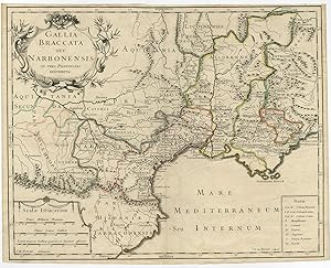
Antique Map of Gallia / Gaul by De Berey (c.1700)
Erscheinungsdatum: 1700
Anbieter: Bartele Gallery - The Netherlands, Langweer, FRL, Niederlande
Verkäuferbewertung 5 von 5 Sternen
Karte
No Binding. Zustand: Good. Antique map titled 'Gallia Braccata seu Narbonensis'. With outline color. Repair on folding line, please study image carefully. Overall size: 48 x 32 cm. Image size: 46 x 37 cm. The collection of Bartele Gallery includes over 50,000 authentic antique maps, sea charts, prints and books. Our Abebooks store includes a selection of maps, prints and books for SALE prices. Please visit our other online sales channels to explore our complete collection of original antique maps and prints!
-
Carte de la Syrie Nouvellement Corrigee. Berey C.A., anno 1727 Carte de la Syrie Nouvellement Corrigee. [Map of Syria, Newly Corrected] Paris / 1727 circa Image Dimensions: 29x27 cm. Rare map of Syria, Lebanon and the Holy Land, published anno 1727 by Claude-Auguste Berey. The map shows the region in fine detail, with mountains, rivers, cities, and more all shown. The map includes an inset map fo the region around Lebanon, showing the cities of Tripoli and Beirut.
Erscheinungsdatum: 1727
Anbieter: Hammelburger Antiquariat, Hammelburg, Deutschland
Verkäuferbewertung 5 von 5 Sternen
Kunst / Grafik / Poster
Kein Einband. Zustand: Befriedigend. Carte de la Syrie Nouvellement Corrigee. Berey C.A., anno 1727 Carte de la Syrie Nouvellement Corrigee. [Map of Syria, Newly Corrected] Paris / 1727 circa Image Dimensions: 29x27 cm. Rare map of Syria, Lebanon and the Holy Land, published anno 1727 by Claude-Auguste Berey. The map shows the region in fine detail, with mountains, rivers, cities, and more all shown. The map includes an inset map fo the region around Lebanon, showing the cities of Tripoli and Beirut.
-

Graecia.
Erscheinungsdatum: 1663
Anbieter: Altea Antique Maps, London, Vereinigtes Königreich
Verbandsmitglied: ABA ILAB PBFA
Verkäuferbewertung 5 von 5 Sternen
Karte
EUR 2.620,78
EUR 40,48 Versand
Versand von Vereinigtes Königreich nach USAAnzahl: 1 verfügbar
In den WarenkorbParis: Berey, 1663. Original colour. 420 x 520mm. An excellent example. A very uncommon map of Greece, engraved by Jan Swelinck after Nicolas Sanson. The title cartouche features an Ottoman ruler, highlighting the Turkish rule over Greece. ZACHARAKIS: 3608, this early state not listed, only a Langlois edition of '1677?'.


![Bild des Verkäufers für Carte de la Syrie Nouvellement Corrigee. Berey C.A., anno 1727 Carte de la Syrie Nouvellement Corrigee. [Map of Syria, Newly Corrected] Paris / 1727 circa Image Dimensions: 29x27 cm. Rare map of Syria, Lebanon and the Holy Land, published anno 1727 by Claude-Auguste Berey. The map shows the region in fine detail, with mountains, rivers, cities, and more all shown. The map includes an inset map fo the region around Lebanon, showing the cities of Tripoli and Beirut. zum Verkauf von Hammelburger Antiquariat](https://pictures.abebooks.com/inventory/md/md31715098835.jpg)