
Gesamtpreis (1 Artikel Artikel):
Versandziel:

basire isaac (27 Ergebnisse)
Direkt zu den wichtigsten Suchergebnissen
Suchfilter
Produktart
- Alle Product Types
- Bücher (11)
- Magazine & Zeitschriften (Keine weiteren Ergebnisse entsprechen dieser Verfeinerung)
- Comics (Keine weiteren Ergebnisse entsprechen dieser Verfeinerung)
- Noten (Keine weiteren Ergebnisse entsprechen dieser Verfeinerung)
- Kunst, Grafik & Poster (10)
- Fotografien (Keine weiteren Ergebnisse entsprechen dieser Verfeinerung)
- Karten (5)
- Manuskripte & Papierantiquitäten (1)
Zustand Mehr dazu
- Neu (16)
- Wie Neu, Sehr Gut oder Gut Bis Sehr Gut (1)
- Gut oder Befriedigend (6)
- Ausreichend oder Schlecht (Keine weiteren Ergebnisse entsprechen dieser Verfeinerung)
- Wie beschrieben (4)
Einband
Weitere Eigenschaften
- Erstausgabe (1)
- Signiert (Keine weiteren Ergebnisse entsprechen dieser Verfeinerung)
- Schutzumschlag (Keine weiteren Ergebnisse entsprechen dieser Verfeinerung)
- Angebotsfoto (23)
Sprache (2)
Gratisversand
Land des Verkäufers
Verkäuferbewertung
-

The Correspondence of Isaac Basire, DD Archdeacon of Northumberland and Prebendary of Durham in the Reigns of Charles I And Charles II With a Memoir of His Life Classic Reprint
Anbieter: PBShop.store US, Wood Dale, IL, USA
Verkäuferbewertung 5 von 5 Sternen

PAP. Zustand: New. New Book. Shipped from UK. Established seller since 2000.
-
The Correspondence of Isaac Basire, DD Archdeacon of Northumberland and Prebendary of Durham in the Reigns of Charles I And Charles II With a Memoir of His Life Classic Reprint
Anbieter: PBShop.store UK, Fairford, GLOS, Vereinigtes Königreich
Verkäuferbewertung 5 von 5 Sternen
EUR 29,80
EUR 5,86 Versand
Versand von Vereinigtes Königreich nach USAAnzahl: 15 verfügbar
In den WarenkorbPAP. Zustand: New. New Book. Shipped from UK. Established seller since 2000.
-

Loose Leaf. Zustand: New. Reproduction. Original title: Map of Namur German: Karte von Namur French: Carte de Namur Spanish: Mapa de Namur High-quality fine-art reproduction based on an original work from the Rijksmuseum. Creation period: 18th century (1751). Professionally printed on premium fine-art paper (Photo Matt Fibre) in size A5. The motif is printed with a white border (museum-style presentation). No.
-

Loose Leaf. Zustand: New. Reproduction. Original title: Map of Ghent German: Karte von Gent French: Carte de Gand Spanish: Mapa de Gante High-quality fine-art reproduction based on an original work from the Rijksmuseum. Creation period: 18th century (1751). Professionally printed on premium fine-art paper (Photo Matt Fibre) in size A5. The motif is printed with a white border (museum-style presentation). No.
-

Loose Leaf. Zustand: New. Reproduction. Original title: Map of Bergen (Mons) German: Karte von Bergen (Mons) French: Carte de Bergen (Mons) Spanish: Mapa de Bergen (Mons) High-quality fine-art reproduction based on an original work from the Rijksmuseum. Creation period: 18th century (1751). Professionally printed on premium fine-art paper (Photo Matt Fibre) in size A5. The motif is printed with a white border (museum-style presentation). No.
-

Loose Leaf. Zustand: New. Reproduction. Original title: Map of Bruges German: Karte von Brügge French: Carte de Bruges Spanish: Mapa de Brujas High-quality fine-art reproduction based on an original work from the Rijksmuseum. Creation period: 18th century (1751). Professionally printed on premium fine-art paper (Photo Matt Fibre) in size A5. The motif is printed with a white border (museum-style presentation). No.
-

Loose Leaf. Zustand: New. Reproduction. Original title: Ypres Foundation Map German: Karte der Ypres-Stiftung French: Carte de la Fondation Ypres Spanish: Mapa de la Fundación Ypres High-quality fine-art reproduction based on an original work from the Rijksmuseum. Creation period: 18th century (1751). Professionally printed on premium fine-art paper (Photo Matt Fibre) in size A5. The motif is printed with a white border (museum-style presentation). No.
-

Loose Leaf. Zustand: New. Reproduction. Original title: Map of Nieuwpoort German: Karte von Nieuwpoort French: Carte de Nieuwpoort Spanish: Mapa de Nieuwpoort High-quality fine-art reproduction based on an original work from the Rijksmuseum. Creation period: 18th century (1751). Professionally printed on premium fine-art paper (Photo Matt Fibre) in size A5. The motif is printed with a white border (museum-style presentation). No.
-

Loose Leaf. Zustand: New. Reproduction. Original title: Map of Brussels German: Karte von Brüssel French: Carte de Bruxelles Spanish: Mapa de Bruselas High-quality fine-art reproduction based on an original work from the Rijksmuseum. Creation period: 18th century (1751). Professionally printed on premium fine-art paper (Photo Matt Fibre) in size A5. The motif is printed with a white border (museum-style presentation). No.
-

Loose Leaf. Zustand: New. Reproduction. Original title: Map of Antwerp German: Karte von Antwerpen French: Carte de Anvers Spanish: Mapa de Amberes High-quality fine-art reproduction based on an original work from the Rijksmuseum. Creation period: 18th century (1751). Professionally printed on premium fine-art paper (Photo Matt Fibre) in size A5. The motif is printed with a white border (museum-style presentation). No.
-

The Correspondence of Isaac Basire, DD Archdeacon of Northumberland and Prebendary of Durham in the Reigns of Charles I And Charles II With a Memoir of His Life Classic Reprint
Anbieter: PBShop.store US, Wood Dale, IL, USA
Verkäuferbewertung 5 von 5 Sternen
HRD. Zustand: New. New Book. Shipped from UK. Established seller since 2000.
-
The Correspondence of Isaac Basire, DD Archdeacon of Northumberland and Prebendary of Durham in the Reigns of Charles I And Charles II With a Memoir of His Life Classic Reprint
Anbieter: PBShop.store UK, Fairford, GLOS, Vereinigtes Königreich
Verkäuferbewertung 5 von 5 Sternen
EUR 38,22
EUR 6,85 Versand
Versand von Vereinigtes Königreich nach USAAnzahl: 15 verfügbar
In den WarenkorbHRD. Zustand: New. New Book. Shipped from UK. Established seller since 2000.
-

EUR 21,84
EUR 48,99 Versand
Versand von Deutschland nach USAAnzahl: Mehr als 20 verfügbar
In den WarenkorbZustand: New.
-

Remarks Upon The Defects And Inaccuracies Of 'the Correspondence Of Isaac Basire, By W.n. Darnell'
Sprache: Englisch
Verlag: Creative Media Partners, LLC Mär 2019, 2019
ISBN 10: 1010673351 ISBN 13: 9781010673354
Anbieter: AHA-BUCH GmbH, Einbeck, Deutschland
Verkäuferbewertung 5 von 5 Sternen
Taschenbuch. Zustand: Neu. Neuware.
-

EUR 43,88
EUR 48,99 Versand
Versand von Deutschland nach USAAnzahl: Mehr als 20 verfügbar
In den WarenkorbGebunden. Zustand: New. KlappentextThis work has been selected by scholars as being culturally important, and is part of the knowledge base of civilization as we know it. This work was reproduced from the original artifact, and remains as true to the original w.
-

The Correspondence of Isaac Basire, With a Memoir of His Life by W.N. Darnell
Sprache: Englisch
Verlag: Creative Media Partners, LLC Mai 2016, 2016
ISBN 10: 1358288755 ISBN 13: 9781358288753
Anbieter: AHA-BUCH GmbH, Einbeck, Deutschland
Verkäuferbewertung 5 von 5 Sternen
Buch. Zustand: Neu. Neuware - This work has been selected by scholars as being culturally important, and is part of the knowledge base of civilization as we know it. This work was reproduced from the original artifact, and remains as true to the original work as possible. Therefore, you will see the original copyright references, library stamps (as most of these works have been housed in our most important libraries around the world), and other notations in the work.This work is in the public domain in the United States of America, and possibly other nations. Within the United States, you may freely copy and distribute this work, as no entity (individual or corporate) has a copyright on the body of the work.As a reproduction of a historical artifact, this work may contain missing or blurred pages, poor pictures, errant marks, etc. Scholars believe, and we concur, that this work is important enough to be preserved, reproduced, and made generally available to the public. We appreciate your support of the preservation process, and thank you for being an important part of keeping this knowledge alive and relevant.
-
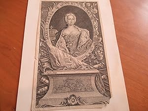
Maria Teresa, Q. Of Hungary Born May 13Th. 1717 (Original Antique Engraving)
Sprache: Englisch
Erscheinungsdatum: 1742
Anbieter: Arroyo Seco Books, Pasadena, Member IOBA, Pasadena, CA, USA
Verbandsmitglied: IOBA
Verkäuferbewertung 4 von 5 Sternen

Kunst / Grafik / Poster Erstausgabe
No Binding. Zustand: Near Fine. 1st Edition. Original Engraving, Originally Issued As One Of Four Images On A Single Sheet, With Two Views Of Prague And A Map . Part Of A Large Collection Of Original Antique Engravings Formed By A Southern California Artist In The Early To Middle Twentieth Century. Each Plate Has Small Glue Marks On Reverse Where They Were Tipped In To An Album. This Engraving Has A Small Loss At Lower Right Corner.
-

Plan of the Battle of Eckeren.
Verlag: c1745., 1745
Anbieter: Asia Bookroom ANZAAB/ILAB, Canberra, ACT, Australien
Verkäuferbewertung 5 von 5 Sternen
Highly detailed copper engraved regional map, showing Fort St. Philip, F. de la Croix, F. Liefkenshock and Lillo. Beyond the river are towns, farms and roads. A number of ships in the Escaut. Depicts the French attack of June 30, 1703. Trifle browned in the left section of the image but otherwise very good. Large title cartouche. From Tindal's Continuation of Rapin's History. The cartouche reads: Eckeren - A Village in the Netherlands, in Brabant, in the county of Ryem, at which were attacked by ye French, 30 June 1703.
-

Antient Germany.
Verlag: London: 1745, 1745
Anbieter: Peter Harrington. ABA/ ILAB., London, Vereinigtes Königreich
Verbandsmitglied: ABA ILAB PBFA
Verkäuferbewertung 5 von 5 Sternen
EUR 90,18
EUR 25,68 Versand
Versand von Vereinigtes Königreich nach USAAnzahl: 1 verfügbar
In den WarenkorbAn interesting map of the Northern parts of Germany with the names of the ancient tribes that inhabited them. Copper engraving. Hand coloured. Size: 226 x 314 mm Good condition. A repaired tear to lower right corner.
-

Mapa Antiguo - Old Map : PLAN OF CARDONA A STRONG CITY AND CASTLE OF CATALONIA, upon the River CARDONER as besieged by the French and defended by the Allies.
Verlag: Ed Tindal, Rapin, Paris, 1745
Anbieter: LIBRERÍA MAESTRO GOZALBO, Carcaixent, V, Spanien
Verkäuferbewertung 5 von 5 Sternen
Karte
Zustand: Buen estado. 1 lámina sin enmarcar Buen estado Grabado en plancha de cobre por J Basire. For Tindal's continuation of Rapin's History of England.
-

A Pholey Town & Plantations about it, from Moore (Illust).
Verlag: London: Gentleman's Magazine, [1745?]., 1745
Anbieter: Wittenborn Art Books, San Francisco, CA, USA
Verkäuferbewertung 5 von 5 Sternen
Manuskript / Papierantiquität
Zustand: Good. 14 x 9 inches. Very Good. Laid paper. Travels into the inland parts of Africa: containing a description of the several nations for the space of six hundred miles up the River Gambia; their trade, habits, customs, language, manners, religion and government; the power, disposition and characters of some Negro princes; with a particular account of Job Ben Solomon. Scarce.Isaac Basire (1704 - 1768) was an engraver and first in a family line of prolific and well-respected engravers. Isaac Basire was known as a map engraver. His most well-known work is the frontispiece to an edition of Bailey's dictionary (1755).
-
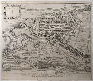
Cony, a strong City of Piedmont in the States of Savoy.
Verlag: London-47, 1743
Anbieter: Robert Frew Ltd. ABA ILAB, London, Vereinigtes Königreich
Verbandsmitglied: ABA ILAB PBFA
Verkäuferbewertung 5 von 5 Sternen
Karte
EUR 180,36
EUR 11,67 Versand
Versand von Vereinigtes Königreich nach USAAnzahl: 1 verfügbar
In den Warenkorb41 x 48 cm. Uncoloured. Double page plan of Cuneo. 4cm tear without loss to lower margin affecting 2mm of plate. Generally very good.
-

Mapa Antiguo - Old Map : PLAN of the TOWN and CASTLE of LERIDA, with the Approaches made before it by the French & Spanish Armies under the command of the D of Orleans during the Siege began Oct 2, 1707
Verlag: Ed Tindal, Rapin, London, 1745
Anbieter: LIBRERÍA MAESTRO GOZALBO, Carcaixent, V, Spanien
Verkäuferbewertung 5 von 5 Sternen
Karte
Zustand: Buen estado. 1 lámina sin enmarcar Buen estado Grabado en plancha de cobre por J Basire. For Tindal's continuation of Rapin's History of England. Coloreado a mano.
-

Zustand: ACEPTABLE. Formato (cm): 31x21.
-

Mapa Antiguo - Old Map : DRAUGHT of ye BAY of BULLS between the TOWN of ROTTA and FORT St CATHERINE,
Verlag: Ed Tindal, Rapin, London, 1745
Anbieter: LIBRERÍA MAESTRO GOZALBO, Carcaixent, V, Spanien
Verkäuferbewertung 5 von 5 Sternen
Karte
Zustand: Buen estado. 1 lámina sin enmarcar Buen estado Grabado en plancha de cobre por J Basire. For Tindal's continuation of Rapin's History of England. Coloreado a mano. Draught of ye. Bay of Bulls between the town of Rotta and Fort St. Catherine, under the Command of his Grace the Duke of Ormond; with the disposition of the Firgates which were ordered ot stand in by the Shore, to favour the Landing; as also the Situation of the Ground and Bay, with that of the Enemy s Batteries & Troops. Grabado al acero con texto al pie.
-
Antique Map-BATTLE-OSTEND-BELGIUM-MILITARY MAP-BATTLE LINES-SHIPS-Basire-1744
Erscheinungsdatum: 1744
Anbieter: Pictura Prints, Art & Books, Overasselt, Niederlande
Verkäuferbewertung 5 von 5 Sternen
'PLAN OF THE INVESTITURE OF OSTEND SURRENDERED, 6 JULY, 1706.'This print shows a map of the View of the City of Ostend in Belgium. A military map showing battle lines and positions, contours and geographical features such as buildings, fortifications, fields and rivers. Ships in the North Sea.Made by after an anonymous artist.Medium: Engraving on hand laid (verge) paper.Sheet size: 51 x 40 cm (20.08 x 15.75 inch). Image size: 47.5 x 38 cm. (18.7 x 14.96 inch).BATTLE-OSTEND-BELGIUM-MILITARY MAP-BATTLE LINES-SHIPS | RB-T.29-LARGEBACKGROUND INFORMATIONThis attractive print was published by Knapton, John and Paul, London, 1744. From Thomas Rapin's History of England. Condition: good, given age. Folds as published. Creasing in upper margin and upper right corner. Paper separation at top and bottom fold, backed. General age-related toning and/or occasional minor defects from handling. Please study scan carefully.
-
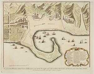
Plan of the Works of the City of Messina, one of the strongest and most considerable Cities of Sicily, and a fine Sea-port.
Erscheinungsdatum: 1750
Anbieter: Altea Antique Maps, London, Vereinigtes Königreich
Verbandsmitglied: ABA ILAB PBFA
Verkäuferbewertung 5 von 5 Sternen
Karte
EUR 216,43
EUR 40,86 Versand
Versand von Vereinigtes Königreich nach USAAnzahl: 1 verfügbar
In den WarenkorbNo Binding. Zustand: Good. London, Rapin & Tindall, c.1750. Coloured. 380 x 480mm. Engraved by Basire for Rapin's History of England, with an extensive key.
