Gesamtpreis (1 Artikel Artikel):
Versandziel:

bankes thomas (21 Ergebnisse)
Direkt zu den wichtigsten Suchergebnissen
Suchfilter
Produktart
- Alle Product Types
- Bücher (15)
- Magazine & Zeitschriften (Keine weiteren Ergebnisse entsprechen dieser Verfeinerung)
- Comics (Keine weiteren Ergebnisse entsprechen dieser Verfeinerung)
- Noten (Keine weiteren Ergebnisse entsprechen dieser Verfeinerung)
- Kunst, Grafik & Poster (4)
- Fotografien (Keine weiteren Ergebnisse entsprechen dieser Verfeinerung)
- Karten (2)
- Manuskripte & Papierantiquitäten (Keine weiteren Ergebnisse entsprechen dieser Verfeinerung)
Zustand Mehr dazu
- Neu (7)
- Wie Neu, Sehr Gut oder Gut Bis Sehr Gut (1)
- Gut oder Befriedigend (5)
- Ausreichend oder Schlecht (Keine weiteren Ergebnisse entsprechen dieser Verfeinerung)
- Wie beschrieben (8)
Einband
Weitere Eigenschaften
- Erstausgabe (1)
- Signiert (Keine weiteren Ergebnisse entsprechen dieser Verfeinerung)
- Schutzumschlag (Keine weiteren Ergebnisse entsprechen dieser Verfeinerung)
- Angebotsfoto (17)
Sprache (3)
Preis
- Beliebiger Preis
- Weniger als EUR 20 (Keine weiteren Ergebnisse entsprechen dieser Verfeinerung)
- EUR 20 bis EUR 45
- Mehr als EUR 45
Gratisversand
- Kostenloser Versand nach USA (Keine weiteren Ergebnisse entsprechen dieser Verfeinerung)
Land des Verkäufers
Verkäuferbewertung
-

A new and authentic system of universal geography, antient and modern: including all the late important discoveries made by the English, and other ... various nations, in the different hemispheres
Sprache: Englisch
Verlag: Gale Ecco, Print Editions, 2010
ISBN 10: 1171450281 ISBN 13: 9781171450283
Anbieter: Ria Christie Collections, Uxbridge, Vereinigtes Königreich
Verkäuferbewertung 5 von 5 Sternen

EUR 33,34
EUR 13,86 Versand
Versand von Vereinigtes Königreich nach USAAnzahl: Mehr als 20 verfügbar
In den WarenkorbZustand: New. In.
-

The Emergence of Peer Competitors: A Framework for Analysis
Anbieter: Revaluation Books, Exeter, Vereinigtes Königreich
Verkäuferbewertung 5 von 5 Sternen
EUR 41,53
EUR 11,57 Versand
Versand von Vereinigtes Königreich nach USAAnzahl: 1 verfügbar
In den WarenkorbPaperback. Zustand: Brand New. 171 pages. 8.75x8.75x0.50 inches. In Stock.
-

A new and Authentic System of Universal Geography, Antient and Modern: Including all the Late Important Discoveries Made by the English, and Other ... in the Different Hemispheres of 2; Volume 1
Sprache: Englisch
Verlag: Gale Ecco, Print Editions, 2018
ISBN 10: 1385817828 ISBN 13: 9781385817827
Anbieter: Ria Christie Collections, Uxbridge, Vereinigtes Königreich
Verkäuferbewertung 5 von 5 Sternen
EUR 42,94
EUR 13,86 Versand
Versand von Vereinigtes Königreich nach USAAnzahl: Mehr als 20 verfügbar
In den WarenkorbZustand: New. In.
-

A New and Authentic System of Universal Geography, Antient and Modern
Sprache: Englisch
Verlag: Gale Ecco, Print Editions, 2010
ISBN 10: 1171450281 ISBN 13: 9781171450283
EUR 39,30
EUR 48,99 Versand
Versand von Deutschland nach USAAnzahl: Mehr als 20 verfügbar
In den WarenkorbZustand: New.
-

EUR 49,64
EUR 48,99 Versand
Versand von Deutschland nach USAAnzahl: Mehr als 20 verfügbar
In den WarenkorbEinband - fest (Hardcover). Zustand: New.
-
![Bild des Verkäufers für A New and Authentic System of Universal Geography, Antient and Modern [microform]: Including All the Late Important Discoveries Made by the English, a zum Verkauf von AHA-BUCH GmbH](https://pictures.abebooks.com/inventory/md/md31915224479.jpg)
A New and Authentic System of Universal Geography, Antient and Modern [microform]: Including All the Late Important Discoveries Made by the English, a
Sprache: Englisch
Verlag: Creative Media Partners, LLC Sep 2021, 2021
ISBN 10: 1015076661 ISBN 13: 9781015076662
Anbieter: AHA-BUCH GmbH, Einbeck, Deutschland
Verkäuferbewertung 5 von 5 Sternen
Taschenbuch. Zustand: Neu. Neuware.
-
![Bild des Verkäufers für A New and Authentic System of Universal Geography, Antient and Modern [microform] : Including All the Late Important Discoveries Made by the English, and Other Celebrated Navigators of Various Nations, in the Different Hemispheres; From the Celebrated. zum Verkauf von AHA-BUCH GmbH](https://pictures.abebooks.com/inventory/md/md31912911786.jpg)
A New and Authentic System of Universal Geography, Antient and Modern [microform] : Including All the Late Important Discoveries Made by the English, and Other Celebrated Navigators of Various Nations, in the Different Hemispheres; From the Celebrated.
Sprache: Englisch
Verlag: Creative Media Partners, LLC Sep 2021, 2021
ISBN 10: 1013828313 ISBN 13: 9781013828317
Anbieter: AHA-BUCH GmbH, Einbeck, Deutschland
Verkäuferbewertung 5 von 5 Sternen
Buch. Zustand: Neu. Neuware.
-
Various Instruments used by the Natives of Ohaheite. Double Page Antique Engraving Showing Various Tools Axe, Tattoo Needle, Scrapers, Tahiti, Tahitian Tools, Instruments & Flute - Cook
Verlag: Charles Cook 1787, 1787
Anbieter: PROCTOR / THE ANTIQUE MAP & BOOKSHOP, DORCHESTER, Vereinigtes Königreich
Verbandsmitglied: PBFA
Verkäuferbewertung 5 von 5 Sternen
Kunst / Grafik / Poster
EUR 39,31
EUR 23,13 Versand
Versand von Vereinigtes Königreich nach USAAnzahl: 1 verfügbar
In den WarenkorbDouble Plate Size 15.5 x 9 inches. Black & White Engraving. Unframed In good condition. Some light tanning & a few small marks. This fine original cooper-plate engraved antique print of various Instruments and tools of Tahiti and surrounding Islands visited by Captain James Cook in 1769, during his First Voyage of Discovery was published in Thomas Bankes 1787 edition of A New, Royal and Authentic System of Universal Geography, Antient and Modern. printed by Charles Cook, London.
-

A perspective View of the City of Dublin, from Phoenix Park
Verlag: London, 1790
Anbieter: Clive A. Burden Ltd., Chalfont St. Giles, BUCKS, Vereinigtes Königreich
Verkäuferbewertung 5 von 5 Sternen
Karte
EUR 59,56
EUR 25,62 Versand
Versand von Vereinigtes Königreich nach USAAnzahl: 1 verfügbar
In den WarenkorbNo binding. 180 x 265 mm., in good condition. This fine copper plate engraving of the city of Dublin is from Thomas Bankes' 'New and Complete System of Geography'.
-
A New Royal Authentic and Complete System of Universal Geography Antient and Modern: including All the Late Important Discoveries Made by the English, and Other Celebrated Navigators of Various Nations, in the Different Hemispheres; .
Verlag: J Cooke, London, 1787
Anbieter: Barter Books Ltd, Alnwick, NORTH, Vereinigtes Königreich
Verbandsmitglied: IOBA
Verkäuferbewertung 5 von 5 Sternen
EUR 1.501,03
EUR 9,25 Versand
Versand von Vereinigtes Königreich nach USAAnzahl: 1 verfügbar
In den WarenkorbBrown hardback leather cover. Zustand: Good. Reprint. G : in good condition. Cover worn with loss to leather. Front board loose. Worming (extinct) to prelims. Occasional foxing and marks. 390mm x 260mm (15" x 10"). 990pp, [vi] + plates. 90 b/w plates + 18 b/w maps (8 fold-out). . And Containing a Complete Genuine History and Description of the Whole World, . with an Account of the Rise, Progress, and Present State of Navigation throughout the Known World. 2 volumes bouns as 1. William Cooper His Booke. Heavy book extra shipping needed for overseas.
-

A New Royal Authentic and Complete System of Universal Geography Antient and Modern: &c. &c. [Bankes' New System of Universal Geography]
Verlag: J. Cooke, London, 1787
Anbieter: Arapiles Mountain Books - Mount of Alex, Castlemaine, VIC, Australien
Verkäuferbewertung 5 von 5 Sternen
Erstausgabe
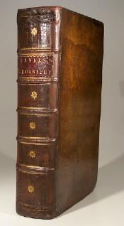
Hard Cover. Zustand: G+. First Edition. Undated, but 1787-1788. 2 vols. Elephant Folio. original full calf gilt, spine labels (rubbed & worn, rebacked with original spines laid-down, hinges slackening, cloth tape strengthening to hinges, both volumes, some chipping to leather, amateurish repairs, internally clean & complete); pp. [iv], 1-460, with frontispiece, 94 plates (full-page, 1/2 page &1/4 page) on 51 sheets, 6 folding maps/charts + 1 full page; [ii (title, last blank)], 461-990 (page 663 erroneously labelled 635), [4 (list of Subscribers), misbound between p.988 & 989], 2 [Directions to the Binder for placing the cuts]), with 70 plates (full-page & 1/2 page) on 39 sheets, 6 folding maps/charts + 10 full page (see Alan Frost in La Trobe Journal No. 8, October 1971 for a history of the book, highlighting differences in content and pagination between editions). Very heavy set (9 kg), additional postage may be required for international and domestic delivery. A good copy of an early issue, intact but would benefit from some restoration. Ex-libris Charles Scobie (ANARE, Macquarie Island, 1948), with his ownership signature and date (29-5-1941) to rear pastedown.
-
A Modern, Authentic and Complete System of Universal Geography
Verlag: C.Cooke, London, 1793
Anbieter: Wadard Books PBFA, Farningham, KENT, Vereinigtes Königreich
Verbandsmitglied: PBFA
Verkäuferbewertung 4 von 5 Sternen

EUR 4.109,95
EUR 24,29 Versand
Versand von Vereinigtes Königreich nach USAAnzahl: 1 verfügbar
In den WarenkorbHardcover. Zustand: Very Good. Undated circa 1793. The content based on information received up until 1793. 6+990pp+2 - 88 plates, 22 maps. Whilst the scope purports to be the genuine history and description of the Whole World, such was the importance of Cook's discoveries that the first 106pp incorporating 25 plates and three maps is taken up with Cook's voyages. To this is included a particular description of the improved state of the New Colony formed at Port Jackson and Norfolk Island, where the convicts are now settled, and an account of the excursions and discoveries made in the interior parts of New Holland. Altogether this is a gargantuan production with stunning plates and maps. Contemporary full calf, superbly rebacked with the original spine relaid. Photographs available on request.
-
A New, Royal and Authentic System of Universal Geography, Antient and Modern:. All the late important Discoveries made by the English, and other celebrated Navigators of various Nations, in the different Hemispheres, from the Celebrated Columbus, the first Discoverer of America, to the Death of our no less celebrated Countryman Captain Cook, & c. and the Latest Accounts of the English Colony of Botany Bay:.
Verlag: C. Cooke, London, 1789
Anbieter: Antipodean Books, Maps & Prints, ABAA, Garrison, NY, USA
Verbandsmitglied: ABAA ANZAAB ESA ILAB
Verkäuferbewertung 3 von 5 Sternen

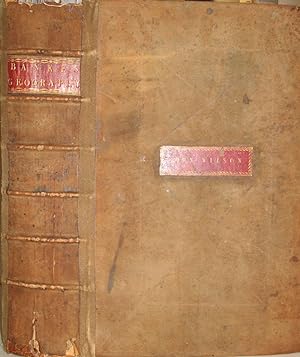
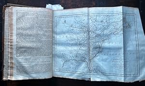
Hardcover. 2nd or 3rd edition. Likely to be an original subscriber's copy, listed as "Wilson - Crown Court, Broad St.", likely to be "John Wilson" whose red gilt leather ownership label is mounted into the front board, with special blind tooled lines surrounding it. A second or third edition, published between 1789 & 1791, according to research by Alan Frost published in the LaTrobe Journal of the State Library of Victoria, No. 8, 1971. A very bright unsophisticated copy of this work, which has become increasingly scarce. Ferguson 59 describes a 1 volume edition & cites only the Mitchell Library copy. Many of the illustrations were derived from Cook's Voyages, and were the most generally available representations of the natives of the Pacific Northwest, Tasmania, New Zealand, Hawaii & the Pacific accessible to the public at the time. It is these contemporary images which make this work scarce as so many have been broken up. Folio. Frontispiece, title page, (verso blank), (i) Royal Licence, (ii) Address to the Reader, (1)-990 Texts, etc. +2 pp Directions to the Binder, 2 pp A List of Subscribers, Complete with 90 plates & 22 maps (the map of Great Britain has original hand color; the map of Europe has been hand colored, not unpleasantly but not professionally). Maps and plates are in very good + condition with no refolding or cracking which is usual in this work. Bound in period reversed calf, red gilt title label on spine. Matching early reverse calf strengthening of outer hinge, a couple of splits on leather of spine and very chipped at top and bottom, o/w a very nice copy. "The geography books which appeared in the closing decades of the eighteenth century. are of considerable significance to students of the history of ideas, for the light they shed on English interest in geography and geographical exploration at the end of the eighteenth century. One of the most imposing of these usually quite imposing books is Thomas Bankes, Edward Warren Blake, and Alexander Cook's A New Royal Authentic and Complete System of Universal Geography. A massive folio volume this was a popular work, running to six editions in the ten years from 1787 to 1797."(Frost, Thomas Bankes's Complete System, The La Trobe Journal, 1971). Extedned title - All the late important Discoveries made by the English, and other celebrated Navigators of various Nations, in the different Hemispheres, from the Celebrated Columbus, the first Discoverer of America, to the Death of our no less celebrated Countryman Captain Cook, & c. and the Latest Accounts of the English Colony of Botany Bay:.
-

A Perspective View of the Bank of England.
Verlag: London: c 1775, 1775
Anbieter: Peter Harrington. ABA/ ILAB., London, Vereinigtes Königreich
Verbandsmitglied: ABA ILAB PBFA
Verkäuferbewertung 5 von 5 Sternen
EUR 113,17
EUR 25,45 Versand
Versand von Vereinigtes Königreich nach USAAnzahl: 1 verfügbar
In den WarenkorbEstablished in 1694, it is the second oldest central bank in the world. It was established to act as the English Government's banker, and to this day it still acts as the banker for HM Government. The Bank's headquarters has been located in London's main financial district, the City of London, on Threadneedle Street, since 1734. It is sometimes known as The Old Lady of Threadneedle Street or simply The Old Lady. Size: 400 x250 mm. Copperplate engraving. Good condition.
-

The Royal Exchange.
Verlag: London: c 1775, 1775
Anbieter: Peter Harrington. ABA/ ILAB., London, Vereinigtes Königreich
Verbandsmitglied: ABA ILAB PBFA
Verkäuferbewertung 5 von 5 Sternen
EUR 113,17
EUR 25,45 Versand
Versand von Vereinigtes Königreich nach USAAnzahl: 1 verfügbar
In den WarenkorbThe Royal Exchange was officially opened by Queen Elizabeth I on 23 January 1571. This is an engraving of the second exchange built on the site. It was designed by Edward Jarman, and was opened in 1669, however it unfortunately was destroyed by fire in 1838. The first Royal Exchange was founded by the Elizabethan merchant Sir Thomas Gresham in 1565, to act as a centre of commerce for the city. It was also destroyed by fire in the Great Fire of London in 1666. Size: 250 x370 mm. Copperplate engraving with hand colour. Lower margin slightly chipped, otherwise in good condition.
-

A Man and Woman of the Chipeways to the eastward of the Missisippi in North America. / A Man and Woman of the Nawdowessies of the Missisippi.
Verlag: Artist: Bankes Thomas ca :, 1789
Anbieter: Antique Sommer& Sapunaru KG, München, Deutschland
Verkäuferbewertung 4 von 5 Sternen
Kunst / Grafik / Poster
Technic: Feather Lithography, colorit: colored, condition: Somer stains upper margin, size (in cm): 30,5 x 17,5 cm, View shows two scenes with Native Americans on the Mississippi River. A man and woman with child from the Chipeways east of the Missisippi in North America and a man and woman with child from the Nawdowessies. From Bankes New System of Geography. Engraved by Grignion.
-

View in Anamooka, and the Inhabitants.
Verlag: Artist: Bankes Thomas ca :, 1787
Anbieter: Antique Sommer& Sapunaru KG, München, Deutschland
Verkäuferbewertung 4 von 5 Sternen
Kunst / Grafik / Poster
Technic: Copper print, colorit: original colored, condition: Stain at the outer margin, size (in cm): 21,5 x 30,5 cm, View of the island of Nomuka (Anamooka), a small island in the southern part of the Ha'apai Islands in the Kingdom of Tonga (Friendship Islands). Excerpt from the original illustration by John Webber, artist on the third voyage of James Cook to the South Seas. Thomas Bankes' edition of 'A New, Royal and Authentic System of Universal Geography, Antient and Modern' from the year 1787. Engraved by Roberts.
-
New, Royal, and Authentic System of Universal Geography, Antient and Modern; All the late, important Discoveries, made by the English, and other celebrated Navigators of various Nations, in the different Hemispheres, from the celebrated Columbus, the first Discoverer of America, to the Death of our no less celebrated Countryman Captain Cook, &c. And Containing a Genuine History and Description of the hole World, etc. etc. Europe, Asia, Africa, and America; a Complete Atlas, to which is added a complete Guide to Geography, Astronomy, the Use of the Globes, Maps, &c. Likewise containing every important, interesting, and valuable Discovery throughout the Whole of Captain Cook's Voyages Round the World,. Also containing a Particular Account of
Verlag: Printed for C. Cook. London. ?. 2 volumes. Large folio, 1787
Anbieter: Patrick Pollak Rare Books ABA ILAB, SOUTH BRENT, DEVON, Vereinigtes Königreich
Verkäuferbewertung 3 von 5 Sternen
EUR 1.429,55
EUR 28,91 Versand
Versand von Vereinigtes Königreich nach USAAnzahl: 1 verfügbar
In den Warenkorbpp. (ii), 460; (ii), (461)-970, (ii) Directions to Binder. 22 engraved maps, some folding, by THOMAS BOWEN and 90 engraved plates. Lacking 9 maps [New Discoveries : World : World Chart : Africa : Europe : South America : Great Britain : Asia : Russian Empire] and both frontispieces and 1 plate, with 2 plates erroneously listed. Contemporary calf worn but joints intact, final text leaf to v.I lacking lower half, one other text leaf torn across without loss, a few corners torn, 2 plates damaged with loss at the top margin, occasional marginal tear and loss, offered as a good reading copy.
-

Various Kind of Vessels on the Coast of Malabar - kolorierter Kupferstich. Engreved for T. Bankess complete System of Geography.
Sprache: Deutsch
Verlag: London, Cooke, 1789
Anbieter: Antiquariat Buchseite, Purkersdorf, Österreich
Verkäuferbewertung 5 von 5 Sternen
Kunst / Grafik / Poster
Zustand: Gut. Erstauflage, EA. 1 Blatt in Rahmen hinter Glas mit Passepartout, koloriert, guter Zustand Sprache: Deutsch Gewicht in Gramm: 1100.
-

Winter Palace of the Empress of Russia at Petersburg.
Erscheinungsdatum: 1787
Anbieter: Antiquariaat Dat Narrenschip, Middelburg, Niederlande
Verkäuferbewertung 5 von 5 Sternen
Karte
No Binding. Zustand: Fine. Antique print of The Winter Palace in Saint Petersburg. Backside blank. Copper engraving, published in London 1787-1790 in "A New Royal Authentic and Complete System of Universal Geography," Thomas Bankes. Dimensions (image): 13 x 18 cm.
-
A New and Authentic System of Universal Geography, Antient and Modern: including All the late important Discoveries made by the English, and other celebrated Navigators of various Nations, in the different Hemispheres, and containing a Genuine History and Description of the Whole World,. Together with a complete History of every Empire, Kingdom, and State. I-II.
Anbieter: Bruce Marshall Rare Books, Cheltenham, Vereinigtes Königreich
Verkäuferbewertung 5 von 5 Sternen
EUR 3.573,87
EUR 4,74 Versand
Versand von Vereinigtes Königreich nach USAAnzahl: 1 verfügbar
In den WarenkorbZustand: Very Good. 2 vol.,[2], 460, [2], 461-990, [2]pp., 2 engraved frontispieces, 109 engraved plates (12 folding), contemporary tree calf, spines gilt, green and red morocco labels to spines, folio, London, For C. Cook, [1790?] Bankes' handsomely illustrated compendium of mostly eighteenth-century voyages, with over 100 pages describing the new discoveries in 'New Holland', with three folding maps, updated to include an expedition to Botany Bay "with a particular description of Port Jackson, where the convicts are now settled" undertaken in 1787-1788. There is also several maps and information of New South Wales, Norfolk Island, New Zealand and other Pacific Islands alongside those of Captain Cook's three voyages to the Pacific. Further sections deal with explorations in China, Japan, the Middle East, East Indies, Africa, and America. [ESTC T173389].