Gesamtpreis (1 Artikel Artikel):
Versandziel:

arrowsmith aaron 1750 (18 Ergebnisse)
Direkt zu den wichtigsten Suchergebnissen
Suchfilter
Produktart
- Alle Product Types
- Bücher (17)
- Magazine & Zeitschriften (Keine weiteren Ergebnisse entsprechen dieser Verfeinerung)
- Comics (Keine weiteren Ergebnisse entsprechen dieser Verfeinerung)
- Noten (Keine weiteren Ergebnisse entsprechen dieser Verfeinerung)
- Kunst, Grafik & Poster (Keine weiteren Ergebnisse entsprechen dieser Verfeinerung)
- Fotografien (Keine weiteren Ergebnisse entsprechen dieser Verfeinerung)
- Karten (1)
- Manuskripte & Papierantiquitäten (Keine weiteren Ergebnisse entsprechen dieser Verfeinerung)
Zustand Mehr dazu
- Neu (2)
- Wie Neu, Sehr Gut oder Gut Bis Sehr Gut (Keine weiteren Ergebnisse entsprechen dieser Verfeinerung)
- Gut oder Befriedigend (1)
- Ausreichend oder Schlecht (Keine weiteren Ergebnisse entsprechen dieser Verfeinerung)
- Wie beschrieben (15)
Einband
Weitere Eigenschaften
- Erstausgabe (3)
- Signiert (Keine weiteren Ergebnisse entsprechen dieser Verfeinerung)
- Schutzumschlag (Keine weiteren Ergebnisse entsprechen dieser Verfeinerung)
- Angebotsfoto (7)
Sprache (2)
Gratisversand
Land des Verkäufers
Verkäuferbewertung
-
![Beispielbild für A New and Elegant General Atlas [cartographic Material]: Comprising All the New Discoveries, to the Present Time; Containing Sixty-three Maps zum Verkauf von Ria Christie Collections](https://pictures.abebooks.com/isbn/9781014804327-de-300.jpg)
A New and Elegant General Atlas [cartographic Material]: Comprising All the New Discoveries, to the Present Time; Containing Sixty-three Maps
Anbieter: Ria Christie Collections, Uxbridge, Vereinigtes Königreich
Verkäuferbewertung 5 von 5 Sternen

EUR 17,57
EUR 13,82 Versand
Versand von Vereinigtes Königreich nach USAAnzahl: Mehr als 20 verfügbar
In den WarenkorbZustand: New. In.
-
![Beispielbild für A New and Elegant General Atlas [cartographic Material]: Comprising All the New Discoveries, to the Present Time; Containing Sixty-three Maps zum Verkauf von Ria Christie Collections](https://pictures.abebooks.com/isbn/9781019457160-de-300.jpg)
A New and Elegant General Atlas [cartographic Material]: Comprising All the New Discoveries, to the Present Time; Containing Sixty-three Maps
Anbieter: Ria Christie Collections, Uxbridge, Vereinigtes Königreich
Verkäuferbewertung 5 von 5 Sternen
EUR 30,91
EUR 13,82 Versand
Versand von Vereinigtes Königreich nach USAAnzahl: Mehr als 20 verfügbar
In den WarenkorbZustand: New. In.
-

An Atlas Of Ancient Geography, for the use of King's College School.
Verlag: London: J.Arrowsmith And B.Fellowes, 1842., 1842
Anbieter: D & E LAKE LTD. (ABAC/ILAB), Toronto, ON, Kanada
Verkäuferbewertung 2 von 5 Sternen

8vo. engraved title, engraved index, & 19 engraved maps with outline colour. later cloth (centre fold tears to margins of a few maps, 1 trimmed & mounted with long tear repaired).
-
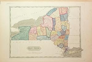
A New and Elegant General Atlas, comprising all the new discoveries, to the present time; containing Sixty-Three Maps, drawn by Arrowsmith and Lewis
Verlag: Philadelphia; Baltimore; Washington City; Petersburg; Norfolk: John Conrad & Co., et al., 1804., 1804
Anbieter: Arader Galleries - AraderNYC, New York, NY, USA
Verkäuferbewertung 5 von 5 Sternen
Erstausgabe
4to., 10 x 13 ˝ inches. 63 engraved maps, several of which are folding, complete as issued, with title page, and list of maps, maps colored in early hand, and numbered in ink manuscript in upper right corners (both title page and list of maps pages torn with rough repairs, heavy foxing affecting some maps, short tears). Original half parchment on marbled paste boards (some splitting, staining on boards including early ink stain on bottom edge, shelf wear). Provence: Manuscript ownership inscriptions on title page "1805". Purchased at Freeman's: April 2016, Sale 1540, Lot 408. On the map of North America the outline of an imagined Nebraska territory is written in a 19th century hand. "FOR PINKERTON'S GEOGRAPHY" added in early manuscript hand to title page. First edition, second issue of Arrowsmith and Lewis's important atlas, with the correct complement of 63 maps called for in the list of contents (the first issue of the same year incorrectly listed 65). The maps are the same in both of the issues. CONTAINS THE FIRST PRINTED MAP OF THE STATE OF OHIO. The original thirteen states are included, and also the District of Maine, Vermont, Kentucky, Tennessee, Ohio (which had been admitted to the Union in 1803), Mississippi Territory, and Louisiana. This complete atlas additionally has maps that cover the known world. "This is a gathering of maps by Arrowsmith and by Lewis. The maps by Arrowsmith are taken from Pinkerton's Modern Geography, London, 1802. Lewis' maps are those of the States and territories. The map of Louisiana is important. The map of Ohio is one of first of state. Wheat, curiously, was unaware of Pinkerton's book." (W. Heckrotte-TW 259). Wheat lists four of the maps included in this atlas and considers them to be significant - Louisiana (Wheat 259), British Possessions in America (Wheat 260), Spanish Dominions in North America (Wheat 261) and North America (Wheat 262) - and says of them collectively "When considered together the four afford a remarkably clear epitome of the knowledge of the West at the moment when Meriwhether Lewis and William Clark were poised for the take-off of their history-making expedition." References: P-LG 702. W-TW 259, 260, 261, 262. Location note: For inquiries please contact Greg McMurray, MLS, Director, Rare Books.
-
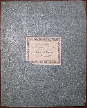
A Comparative Atlas of Ancient and Modern Geography, for the Use of Schools. Compiled from Original Authorities and containing the latest Discoveries.
Verlag: London: John Arrowsmith, 1842., 1842
Anbieter: Arader Galleries - AraderNYC, New York, NY, USA
Verkäuferbewertung 5 von 5 Sternen
Erstausgabe
4to., (11 x 9 inches). (Index a bit browned). 57 fine engraved maps with original hand color in outline (very occasional spotting). Original publisher's green cloth, printed paper label on the front cover (extremities a bit worn). First edition. A comprehensive school atlas, containing 26 ancient maps, each with its corresponding modern equivalent, as well as 4 maps of the new world, including "Western Hemisphere," "North America" (showing Texas as a republic), "United States," "West Indies," and "South America." An acclaimed British cartographer, Aaron Arrowsmith drafted accurate, detailed charts that earned him the titles of Hydrographer to the King of England and Geographer to the Prince of Wales, extremely important distinctions during an era when Britain ruled the seas. An acclaimed British cartographer, Aaron Arrowsmith drafted accurate, detailed charts that earned him the titles of Hydrographer to the King of England and Geographer to the Prince of Wales, extremely important distinctions during an era when Britain ruled the waves. One of the first great British cartographers of North America, Arrowsmith introduced a new standard of excellence in mapmaking in the late 18th century and almost single-handedly made London the center for the cartographic trade. Arrowsmith built his great success on this ability to attract both commercial and general viewers through his combination of visual and scientific appeal. The most influential and respected map publisher of the late 18th and early 19th centuries, Arrowsmith issued maps that were the result of careful synthesis rather than systematic, scientific inquiry. His role in cartographic production was to gather the best available information from a wide variety of sources, weigh the relative merits of conflicting data, and compile the most accurate depiction possible of an area. Arrowsmith accomplished this synthesis better than any other commercial mapmaker of his day and, as a result, his maps were the most sought after and highly prized on three continents. Phillips 6064.
-
A New and Elegant General Atlas. Comprising All the New Discoveries, to the Present Time. Containing Sixty Three Maps, Drawn By Arrowsmith and Lewis. Intended to accompany the new improved edition of Morse's Geography
Verlag: Boston: Thomas & Andrews, May 1812., 1812
Anbieter: Arader Galleries - AraderNYC, New York, NY, USA
Verkäuferbewertung 5 von 5 Sternen
4to., (10 6/8 x 9 inches). Folding engraved double-hemisphere world map, folding map of the "World on Mercator's Projection", and 61 full-page maps (browned, spotted and stained). Contemporary sheep backed formerly marbled paper boards (very worn). Provenance: with the early ownership inscriptions and pen trials of three generations of the Robbins family; given by them to the Scoville Memorial Library in Sausbury Connecticut, with their ink library stamp on the front paste-down. Second edition, first published with fewer maps of America in 1804. Including "the primary map of the newly purchased territory of Louisiana and its surroundings" (Cohen), and making all too clear the limits of geographical knowledge of the country at the time. Based on the apparently solid and experienced cartography of French mapmaker Antoine Soulard, who is given no credit here, the map of Louisiana shows the state stretched almost coast-to-coast, reflecting French pretensions to the territory. The map of the United States extends just west of the Mississippi, which is completely blank except for a rough approximation of the Missouri River up to the 42nd parallel north, approximately. This atlas also clearly portrays the hopes and fears of various competing factions for possession of the North American West. The present mapmakers give some emphasis to British pretensions to the territories shown, while nodding to Spanish and U.S. possessions. In their rather basic form these are the maps that Lewis and Clark relied upon in their explorations, and it was not until the 1814 publication of their report that the inaccuracies could be corrected. With full-page maps of Australasia, Polynesia, North America, the United States, New Hampshire, Massachusetts, Maine, Vermont, Rhode Island, Connecticut, New York, New Jersey, Pennsylvania, Delaware, Maryland, Virginia, North Carolina, South Carolina, Georgia, Kentucky, Tennessee, Ohio, Mississippi Territory, Louisiana, British Possessions in America, Spanish Dominions in North America, the Viceroyalty of New Granada, the Government of Caracas, with Guiana, the Viceroyalty of Peru, Chili, the Viecroyalty of la Plata, the West Indies, South America. Aaron Arrowsmith was a prominent English cartographer, engraver, and publisher, who created about two hundred maps during his illustrious career. He became hydrographer to the Prince of Wales around 1810, and to the King in 1820. Samuel Lewis, noted American draftsman, penman, cartographer, and geographer, published both independently and jointly with Arrowsmith. Samuel Lewis "is to be especially remembered as the draftsman who put in form for publication the celebrated map (originally drawn by William Clark) that in 1814 gave to the world its first detailed reflection of the American Northwest, as Lewis and Clark had pictured it" (Wheat, vol. II, p. 5, footnote 3; see also Wheat 316 and 317). Cohen, p. 80. Phillips A-718.
-
Carte des Etats-Unis de l'Amerique septentrionale copiee et gravee sur celle d'Arrowsmith.
Verlag: Paris: Tardieu, 1820., 1820
Anbieter: Arader Galleries - AraderNYC, New York, NY, USA
Verkäuferbewertung 5 von 5 Sternen
Large folding engraved wall map (61 x 56 4/8 inches) in 16 sections, laid down on brown cartographic linen, edged with silk (two short separations at folds). Showing the United States as far west as Missouri and Arkansas and decorated with a fine vignette of Niagara Falls, and a plan of Washington D.C. dated 1800, with original hand-colour in outline. Preserved in the original marbled paper boards chemise and orange paper boards slipcase (a bit worn at the extremities). A beautiful map, first published by Tardieu in 1802. This French edition of Arrowsmith's seminal map of the United States was first issued by Arrowsmith in 1796. From 1795 to 1857 at least nineteen editions or revisions of Arrowsmith's map of "North America" were published by him or his successors. On the subsequent third edition of 1815 this map, the Missouri River system is based on Lewis and Clark's published map. Arrowsmith's 'Map of the United States of North America' is the most desirable from his well noted career.
-
A Map of the United States of North America, Drawn from a Number of Critical Researches
Verlag: London: A. Arrowsmith, 1796, Additions 1802 [but, After 1808]., 1808
Anbieter: Arader Galleries - AraderNYC, New York, NY, USA
Verkäuferbewertung 5 von 5 Sternen
Fine folding engraved wall map in four separate sheets mounted on cartographic linen (each 25 x 29 inches), each in 15 sections, with EXCEPTIONALLY FINE AND DELICATE ORIGINAL HAND-COLOUR IN FULL, and decorated with a large and fine vignette of Niagara Falls lower right (some light browning and offsetting); original blue paper boards slipcase (quite worn at extremities), title on printed paper label on front cover, and sectional titles on printed labels on verso of each section. Provenance: with the contemporary mapseller's label of C. Smith of the Strand on the verso of one section. AN EXCEPTIONALLY FINE EXAMPLE OF ARROWSMITH'S IMPORTANT MAP of America, first issued 1796, this is the second edition with Additions to 1802, third issue with Arrowsmith's address given as "10 Soho Square", and Arrowsmith is now styled "Hydrographer to H.R.H. the Prince of Wales". The 1802 edition is the last of Arrowsmith's large American maps to be issued before the Louisiana Purchase and it is known that Thomas Jefferson ordered himself a copy at about the same time as the Louisiana Purchase in 1803. It is also the edition that Lewis and Clark consulted for their monumental expedition. Arrowsmith's 'Map of the United States of North America' is the most desirable from his well noted career. An acclaimed British cartographer, Aaron Arrowsmith drafted accurate, detailed charts that earned him the titles of Hydrographer to the King of England and Geographer to the Prince of Wales, extremely important distinctions during an era when Britain ruled the waves. One of the first great British cartographers of North America, Arrowsmith introduced a new standard of excellence in mapmaking in the late 18th century and almost single-handedly made London the center for the cartographic trade. Arrowsmith built his great success on this ability to attract both commercial and general viewers through his combination of visual and scientific appeal. The most influential and respected map publisher of the late 18th and early 19th centuries, Arrowsmith issued maps that were the result of careful synthesis rather than systematic, scientific inquiry. His role in cartographic production was to gather the best available information from a wide variety of sources, weigh the relative merits of conflicting data, and compile the most accurate depiction possible of an area. Arrowsmith accomplished this synthesis better than any other commercial mapmaker of his day and, as a result, his maps were the most sought after and highly prized on three continents. Stephens 79 (e).
-
A Map of the United States of North America, Drawn from a Number of Critical Researches
Verlag: London: A. Arrowsmith, 1796, Additions 1802., 1802
Anbieter: Arader Galleries - AraderNYC, New York, NY, USA
Verkäuferbewertung 5 von 5 Sternen
Fine folding engraved wall map in four separate sheets mounted on cartographic linen with silked edges (each 25 x 29 inches), each in 12 sections, with original hand-colour in outline, and decorated with a large and fine vignette of Niagara Falls lower right (some light browning and offsetting, silk edges a bit frayed); original blue paper boards slipcase, title in manuscript on label on the front cover. Provenance: withdrawn from the Ipswich Free Museum and Library, with their ink library stamps in two places on the recto, and several places on the verso of the map. A FINE EXAMPLE OF ARROWSMITH'S IMPORTANT MAP of America, first issued 1796, this is the second edition with Additions to 1802, third issue with Arrowsmith's address given as "10 Soho Square", and Arrowsmith is now styled "Hydrographer to H.R.H. the Prince of Wales". The 1802 edition is the last of Arrowsmith's large American maps to be issued before the Louisiana Purchase and it is known that Thomas Jefferson ordered himself a copy at about the same time as the Louisiana Purchase in 1803. It is also the edition that Lewis and Clark consulted for their monumental expedition. Arrowsmith's 'Map of the United States of North America' is the most desirable from his well noted career. An acclaimed British cartographer, Aaron Arrowsmith drafted accurate, detailed charts that earned him the titles of Hydrographer to the King of England and Geographer to the Prince of Wales, extremely important distinctions during an era when Britain ruled the waves. One of the first great British cartographers of North America, Arrowsmith introduced a new standard of excellence in mapmaking in the late 18th century and almost single-handedly made London the center for the cartographic trade. Arrowsmith built his great success on this ability to attract both commercial and general viewers through his combination of visual and scientific appeal. The most influential and respected map publisher of the late 18th and early 19th centuries, Arrowsmith issued maps that were the result of careful synthesis rather than systematic, scientific inquiry. His role in cartographic production was to gather the best available information from a wide variety of sources, weigh the relative merits of conflicting data, and compile the most accurate depiction possible of an area. Arrowsmith accomplished this synthesis better than any other commercial mapmaker of his day and, as a result, his maps were the most sought after and highly prized on three continents. Stephens 79 (e).
-
A New and Elegant General Atlas. Comprising All the New Discoveries, to the Present Time. Containing Sixty Three Maps, Drawn By Arrowsmith and Lewis. Intended to accompany the new improved edition of Morse's Geography.
Verlag: Boston: Thomas & Andrews, May 1812., 1812
Anbieter: Arader Galleries - AraderNYC, New York, NY, USA
Verkäuferbewertung 5 von 5 Sternen
4to., (10 6/8 x 9 inches). Folding engraved double-hemisphere world map, folding maps of the "World on Mercator's Projection", and 61 full-page maps (browned and waterstained). Contemporary sheep backed marbled paper boards (worn). Second edition, first published with fewer maps of America in 1804. With full-page maps of Australasia, Polynesia, North America, the United States, New Hampshire, Massachusetts, Maine, Vermont, Rhode Island, Connecticut, New York, New Jersey, Pennsylvania, Delaware, Maryland, Virginia, North Carolina, South Carolina, Georgia, Kentucky, Tennessee, Ohio, Mississippi Territory, Louisiana, British Possessions in America, Spanish Dominions in North America, the Viceroyalty of New Granada, the Government of Caracas, with Guiana, the Viceroyalty of Peru, Chili, the Viecroyalty of la Plata, the West Indies, South America. Aaron Arrowsmith was a prominent English cartographer, engraver, and publisher, who created about two hundred maps during his illustrious career. He became hydrographer to the Prince of Wales around 1810, and to the King in 1820. Samuel Lewis, noted American draftsman, penman, cartographer, and geographer, published both independently and jointly with Arrowsmith. Samuel Lewis "is to be especially remembered as the draftsman who put in form for publication the celebrated map (originally drawn by William Clark) that in 1814 gave to the world its first detailed reflection of the American Northwest, as Lewis and Clark had pictured it" (Wheat, vol. II, p. 5, footnote 3; see also Wheat 316 and 317). Cohen, p. 80. Phillips A-718. Catalogued by Kate Hunter.
-
A New General Atlas.Exhibiting The Boundaries And Divisions, Also the Chains of Mountains and other Geographical Features of all the Known Countries in the World.
Verlag: London: Longman, Rees, Orme, Brown & Green, 1829., 1829
Anbieter: D & E LAKE LTD. (ABAC/ILAB), Toronto, ON, Kanada
Verkäuferbewertung 3 von 5 Sternen

Hardcover. 4to. [ff. 2]. engraved title vignette. 53 engraved maps (1 double-page). contemporary half roan (very worn, joints partly split, hinges taped, dampstaining to lower margins, pencil notes & doodles on verso of some maps, several penned entries on 2 maps, 1 world map with Australia partly inked in, several ink stains on map of South America, some light foxing, lower outer corner of first few leaves dog-eared). cfNational Maritime Museum, Atlases, 293 (1817).
-

Chart of the Pacific Ocean.
Verlag: Artist: Arrowsmith Aaron ( - 1823 ) London; ca: 1798, 1750
Anbieter: Antique Sommer& Sapunaru KG, München, Deutschland
Verkäuferbewertung 3 von 5 Sternen
Karte
Technic: Copper print, colorit: original colored, condition: Perfect condition, size (in cm): 23 x 35 cm, This nautical chart from 1798 shows the routes and dates of the exploration of the Pacific Ocean with the coasts of China, Russia, western Canada, the USA and South America. It also shows South East Asia, Australia, New Zealand, Japan, Kamchatka and Central America.
-
A New General Atlas, Constructed from the Latest Authorities, by A. Arrowsmith, Hydrographer to the Prince Regent, Exhibiting the Boundaries and Divisions also the Chains of Mountains and other Geographical Features of all the Known Countries in the World; Comprehended in Fifty Three Maps from Original Drawings. First edition.
Verlag: Edinburgh & London : A. Constable & Co. Longman & Company, 1817
Anbieter: Wittenborn Art Books, San Francisco, CA, USA
Verkäuferbewertung 5 von 5 Sternen
Erstausgabe
Zustand: Good. 4to 23.5 x 29cm. Contemporary half red roan binding with printed label, worn. Original prospectus from Tthe Edinburgh Gazetteer boundi n. The atlas includes 53 engraved maps, including two of the world and six of the Americas. Original tissue guards in place.The atlas was first published in 1817 and was reissued a number of times afterward. This is the first edition.OCLC Number / Unique Identifier:54151018.David Rumsey (5960) says of the atlas:"Although the maps are not large, they are dense with information. This complete atlas features index and 53 copperplate maps, drawn by Arrowsmith and engraved by Sidney Hall, with a few engraved by Thomson in collaboration with Hall. The maps include two world, 29 related to Europe and Scandinavia, 16 on Asia, Africa, and Oceania, and six related to the Americas. The United States map shows Georgia extending from the coast to the Mississippi River. The area west of the Mississippi is blank and labeled Louisiana. Engraved title page has Atlas holding the globe above two putti, one sailing a dingy, the other engaged in cartographic studies with a globe, map and dividers."I.
-

A Map of the United States of North America Drawn from a Number of Critical Researches. Additions to 1802.
Verlag: London: A. Arrowsmith, 24 Rathbone Place, 1796 (1802), 1802
Anbieter: Arader Galleries - AraderNYC, New York, NY, USA
Verkäuferbewertung 5 von 5 Sternen
Engraved wall map (51 x 57 3/4 in.; 129.5 x 146.7 cm) in 36 sections, backed on linen with green silk selvages, all but the engraved vignette of Niagara Falls with original extensive handcoloring. CONDITION/BINDING: Light scattered foxing extending from the vignette up the Atlantic coast, selvage partially detached in upper left corner. Modern portfolio of marbled paper over pasteboard, old printed paper label. (65B2E) The third issue, with revisions to the Great Lakes region and bearing the Rathbone Place address in the imprint. A slightly later state of the map was used by Lewis and Clarke to plan their epic transcontinental expedition. Aaron Arrowsmith is considered the greatest cartographer of his period, specializing in wall maps prepared to exacting standards, which were frequently revised and improved. PROVENANCE: Sotheby's New York, 17 January 2018, lot 47. REFERENCE: Stevens & Tree 79(c).
-
Asia
Verlag: London: Aaron Arrowsmith, 1 January 1801., 1801
Anbieter: Arader Galleries - AraderNYC, New York, NY, USA
Verkäuferbewertung 5 von 5 Sternen
Fine folding engraved wall map mounted on cartographic linen (50 x 58 4/8 inches) in 24 sections by George Allen, with fine hand-colouring in outline, with the title in a large cartouche top left (some marginal waterstain along the top edge, a bit browned). A fine wall map dedicated to Major James Rennell (1724-1830) and showing the track of the "Lion" in 1793, commanded by Sir Erasmus Gower, the ship which took Lord Macartney embassy to China in 1793 and 1794. It includes all of Asia from the Arabian Gulf in the West, to the Philippines in the southeast, the Arctic circle in the north and the Ceylon in the south. Rennell regarded as "the Father of Indian Surveying" (Gole "Early Maps of India") charted the currents through the India Ocean and around Africa, and later surveyed the Indian interior. He recognized Europe's growing fascination with India: "As almost every particular relating to Hindoostan is become an object of popular curiosity, it can hardly be deemed superfluous to lay before the public an improved system of its geography" (Rennell Preface to "Memoir of a Map of Hindoostan.", 1785). He was appointed at age 24 as surveyor of the British East India Company's dominions in Bengal. In 1765, Rennell began surveying India. By this time, the British East India Company had maintained its foothold on the region for over one hundred years, but it was still another century before Queen Victoria would set her eyes eastward, and Rennell's explorations and accounts helped to fill that gap in time. Rennell combined data from British Army columns with Ain-e-Akbari (1598), a translation of Islamic geography of the empire which helped him acquire information about old divisions (he therefore subdivided the country according to the Mughal provinces of 'subas'). Aaron Arrowsmith's reputation for drafting accurate, detailed charts earned him the titles of Hydrographer to the King of England and Geographer to the Prince of Wales, extremely important distinctions during an era when Britain ruled the waves. One of the first great British cartographers of North America, Arrowsmith introduced a new standard of excellence in mapmaking in the late 18th century and almost single-handedly made London the center for the cartographic trade. Arrowsmith built his great success on this ability to attract both commercial and general viewers through his combination of visual and scientific appeal. The most influential and respected map publisher of the late 18th and early 19th centuries, Arrowsmith issued maps that were the result of careful synthesis rather than systematic, scientific inquiry. His role in cartographic production was to gather the best available information from a wide variety of sources, weigh the relative merits of conflicting data, and compile the most accurate depiction possible of an area. Arrowsmith accomplished this synthesis better than any other commercial mapmaker of his day and, as a result, his maps were the most sought after and highly prized on three continents.
-
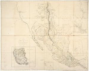
A New Map of Mexico and Adjacent Provinces Compiled from Original Documents by A. Arrowsmith 1810.
Verlag: London: A. Arrowsmith 10 Soho Square, 5th October 1810., 1810
Anbieter: Arader Galleries - AraderNYC, New York, NY, USA
Verkäuferbewertung 5 von 5 Sternen
ARROWSMITH, Aaron (1750-1823). A New Map of Mexico and Adjacent Provinces Compiled from Original Documents by A. Arrowsmith 1810. London: A. Arrowsmith 10 Soho Square, 5th October 1810. Fine folding engraved map (51 x 83 4/8 inches), in 24 sections laid down on cartographic linen. Showing Mexico, extending in the east from the Mississippi Delta to the Pacific Ocean in the west; and north-south from 42° to 15°, thus including present Texas and the Southwest and California to above Mendocino, with 3 insets (some browning). Provenance: from the important cartographical library of Warren Heckrotte, his sale, Rare Cartography, Exploration and Voyages, Part I, 29th October, 2015, lot 107 The most accurate and important map of Texas in the first quarter of the 19th century First issue, stating that Arrowsmith is Hydrographer to H.R.H. the Prince of Wales, rather than to His Majesty, and the eastern boundary of Texas running along the Mermento River, as first delineated by Alexander von Humboldt, beginning "about a hundred miles east of the mouth of the Salinas, or well into Louisiana, at the mouth of what is called the Mermento River, and then runs northeast along that river and then northwest to only a little above the 32nd parallel, and then runs slightly south of west, with San Saba around 100 miles beyond the boundary" (Streeter 1046D). This was the first large-scale map to depict the important discoveries of Pike and Humboldt in the Southwest, and it became the most influential and widely copied map of the region of its the era. The boundary of Texas follows Humboldt's lines. "By combining the best parts of Humboldt's and Pike's maps and avoiding their errors, and by adding his own new information, Arrowsmith contributed a significantly improved depiction of the region" (Martin & Martin 25). The insets are: Valley of Mexico from Mr. Humboldt's Map Vera Cruz Acapulco. Warren Heckrotte writes that "Arrowsmith shows the route of the Dominguez - Escalante expedition. I know of no earlier representation of this expedition. Humboldt did not show it. Where did Arrowsmith get this information? I have the first three issues: this one, the original; additions to 1815, in the atlas to Thomson's Alcedo; and additions to 1816, removed from a copy of the atlas.There is an issue, additions to 1817 and the last issue, ca 1820. I have not determined what changes or additions Arrowsmith made." One of the first great British cartographers of North America, Arrowsmith introduced a new standard of excellence in mapmaking in the late 18th century and almost single-handedly made London the center for the cartographic trade. Arrowsmith built his great success on this ability to attract both commercial and general viewers through his combination of visual and scientific appeal. The most influential and respected map publisher of the late 18th and early 19th centuries, Arrowsmith issued maps that were the result of careful synthesis rather than systematic, scientific inquiry. His role in cartographic production was to gather the best available information from a wide variety of sources, weigh the relative merits of conflicting data, and compile the most accurate depiction possible of an area. Arrowsmith accomplished this synthesis better than any other commercial mapmaker of his day and, as a result, his maps were the most sought after and highly prized on three continents.
-
Map of America
Verlag: London: 24 Rathbone Place, 4th September, 1804, 1804
Anbieter: Arader Galleries - AraderNYC, New York, NY, USA
Verkäuferbewertung 5 von 5 Sternen
ARROWSMITH, Aaron (1750-1823). Map of America. London: 24 Rathbone Place, 4th September, 1804 Magnificent engraved folding map of America, float-mounted and framed (map size: 50 4/8 x 58 4/8 inches), laid down on linen in 24 sections and trimmed with pale blue silk, with original hand-colour in full, the title top right within a superb elaborate vignette by W. & G. Cooke, featuring the bounty of America, including a moose, squirrels, coconut trees and potatoes, with Arrowsmith's Rathbone Place labels on the verso (one torn with loss, silk trim a bit frayed in places). Provenance: with the near contemporary ownership inscription of Grace Grindleford in pencil on the verso First issue of Aaron Arrowsmith's important "Map of America" (1804), published from his Rathbone Place address, and before the recent Louisiana Purchase could be included within the United States. It is one of the rarest and most significant maps Arrowsmith ever produced. The map depicts North and South America and the oceans that stretch between the Sandwich (Hawaii) and Cape Verdes Islands, and draws on a number of sources in order to create his much heralded "Map of America." Building on his earlier map of North America, "A Map Exhibiting all the New Discoveries in the Interior Parts of North America" (1795), Arrowsmith made use of the accounts of Cook, Vancouver, Mears, and La Perouse in order to create his updated 1804 wall chart. Though Meriwether Lewis and William Clark and Alexander von Humboldt had not yet concluded their own expeditions of the continent, Arrowsmith was, nevertheless, able to incorporate the recent findings of Alexander Mackenzie. In 1789, Mackenzie had been commissioned by the North-West Fur Company of Canada (a rival of the Hudson Bay Company) to explore the Rocky Mountains and the Canadian Arctic. Mackenzie's tour of some 2,990 miles was achieved in the astonishing period of 120 days, from Slave Lake to the Arctic shore and back. Mackenzie's atlas, which was published with the account of Vancouver's Pacific voyages in 1798, provided much of the coastal detail for Arrowsmith's highly accurate depictions of British-controlled western Canada and Russian Alaska. Though several editions of Arrowsmith's "Map of America" were released between 1804 and 1840, this example, in its earliest state, shows the Rocky Mountains as a single range, the Missouri River extends far north of its true source, the Columbia River is similarly mislocated, and Vancouver Island is shown as part of the mainland. Nevertheless, this map is successful in a number of other ways. South America is represented with incredible accuracy, the missions in upper California are designated and named, and extensive forts situated in the Mississippi Valley are also shown. One of the first great British cartographers of North America, Arrowsmith introduced a new standard of excellence in mapmaking in the late 18th century and almost single-handedly made London the center for the cartographic trade. Arrowsmith built his great success on this ability to attract both commercial and general viewers through his combination of visual and scientific appeal. The most influential and respected map publisher of the late 18th and early 19th centuries, Arrowsmith issued maps that were the result of careful synthesis rather than systematic, scientific inquiry. His role in cartographic production was to gather the best available information from a wide variety of sources, weigh the relative merits of conflicting data, and compile the most accurate depiction possible of an area. Arrowsmith accomplished this synthesis better than any other commercial mapmaker of his day and, as a result, his maps were the most sought after and highly prized on three continents. Goss, The Mapping of North America 70; Rumsey 2286 (1811 issue); Stevens & Tree, "Comparative Cartography" 1a, in Tooley, The Mapping of America ; Tooley Map 110-2; Map Collector's Circle 68.
-
A Map of the United States of North America.
Verlag: London: A. Arrowsmith, 1796, .Additions .1815, 1815
Anbieter: Arader Galleries - AraderNYC, New York, NY, USA
Verkäuferbewertung 5 von 5 Sternen
ARROWSMITH, Aaron Sr. (1750-1823). A Map of the United States of North America. London: A. Arrowsmith, 1796, .Additions .1815 4 sheets, matted separately (each 26 x 32 inches, full margins showing the plate-mark). An exceptionally fine and detailed map of North America, with original hand-colour in outline, and decorated with a magnificent cartouche of Niagara Falls with printed caption beginning, "Among the many Natural Curiosities which this Country affords, the Cataract of Niagara is infinitely the greatest." lower right. AN EXCEPTIONALLY FINE EXAMPLE OF ARROWSMITH'S IMPORTANT MAP OF THE UNITED STATES, this is the third edition, with additions to 1815, the Missouri River system is based on Lewis and Clark's published map Arrowsmith's 'Map of the United States of North America' is the most desirable from his well noted career. An acclaimed British cartographer, Aaron Arrowsmith drafted accurate, detailed charts that earned him the titles of Hydrographer to the King of England and Geographer to the Prince of Wales, extremely important distinctions during an era when Britain ruled the waves. One of the first great British cartographers of North America, Arrowsmith introduced a new standard of excellence in mapmaking in the late 18th century and almost single-handedly made London the center for the cartographic trade. Arrowsmith built his great success on this ability to attract both commercial and general viewers through his combination of visual and scientific appeal. The most influential and respected map publisher of the late 18th and early 19th centuries, Arrowsmith issued maps that were the result of careful synthesis rather than systematic, scientific inquiry. His role in cartographic production was to gather the best available information from a wide variety of sources, weigh the relative merits of conflicting data, and compile the most accurate depiction possible of an area. Arrowsmith accomplished this synthesis better than any other commercial mapmaker of his day and, as a result, his maps were the most sought after and highly prized on three continents.