Army map service corps engineers (28 Ergebnisse)
Verlag: Washington D. C. 1952
- Karte
Anbieter: Versandantiquariat Hösl, Neuried, , DeutschlandVersandantiquariat Hösl
Verkäufer/-in kontaktierenVerkäufer/-in mit 5 SternenZustand: Gebraucht - Sehr gut
EUR 17,00
EUR 9,50 VersandVersand von Deutschland nach USAAnzahl: 1 verfügbar
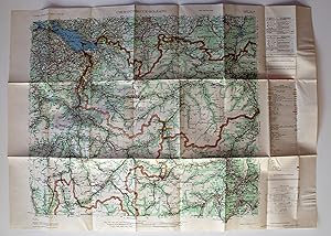
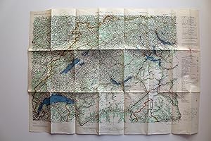
Zustand: Sehr gut. The Army Map Service (AMS) was the military cartographic agency of the United States Department of Defense from 1941 to 1968, subordinated to the United States Army Corps of Engineers.The major task of the Army Map Service was the compilation, publication and distribution of military topographic maps and relat…ed products required by the Armed Forces of the United States.Between 1941 and 1945, the Army Map Service prepared 40,000 maps of all types, covering 400,000 square miles of the earth's surface. (WIkipedia) Große farbige Straßenkarte der Zentralschweiz und Teilen der Nachbarländer Franreich, Deutschland und Italien, vielfach gefaltet, praktisch ohne Gebrauchsspuren und wie neu. Legende in Englisch, Französisch und Deutsch. Gefaltet ist die Größe ca. 21,4 x 12,5 cm. AMS M405. First Edition - AMS. Copied in 1952 from kartogr. Anstalt Freytag-Berndt u. Artaria, Wien, 1:300,000, Auto-Strassenkarten, cartes routières, 1951. Sprache / Language: en 1 Seiten. ca. 62,6 x 88 cm.
Verlag: Washington D.C. 1952
- Erstausgabe
- Karte
Anbieter: Versandantiquariat Hösl, Neuried, , DeutschlandVersandantiquariat Hösl
Verkäufer/-in kontaktierenVerkäufer/-in mit 5 SternenZustand: Gebraucht - Sehr gut
EUR 17,00
EUR 9,50 VersandVersand von Deutschland nach USAAnzahl: 1 verfügbar
Zustand: Sehr gut. 1. Auflage. The Army Map Service (AMS) was the military cartographic agency of the United States Department of Defense from 1941 to 1968, subordinated to the United States Army Corps of Engineers.The major task of the Army Map Service was the compilation, publication and distribution of military topographic ma…ps and related products required by the Armed Forces of the United States.Between 1941 and 1945, the Army Map Service prepared 40,000 maps of all types, covering 400,000 square miles of the earth's surface. (WIkipedia) Große farbige Straßenkarte der Zentralschweiz und Teilen der Nachbarländer Franreich, Deutschland und Italien, vielfach gefaltet, praktisch ohne Gebrauchsspuren und wie neu. Legende in Englisch, Französisch und Deutsch. Gefaltet ist die Größe ca. 21,4 x 12,5 cm. AMS M405. First Edition - AMS. Copied in 1952 from kartogr. Anstalt Freytag-Berndt u. Artaria, Wien, 1:300,000, Auto-Strassenkarten, cartes routières, 1951. Sprache / Language: en 1 Seiten. ca. 62,6 x 88 cm.

Sprache: Englisch
Verlag: Washington, 1962
- Erstausgabe
Anbieter: Books and Beaches, Anna Bechteler, Icking, , DeutschlandBooks and Beaches, Anna Bechteler
Verkäufer/-in kontaktierenVerkäufer/-in mit 5 SternenZustand: Gebraucht - Sehr gut
EUR 18,00
EUR 48,00 VersandVersand von Deutschland nach USAAnzahl: 1 verfügbar
Zustand: Sehr gut. Folding Map 1: 250.000. Very good condition. Uncommon. Showing the area of Leh/Ladakh. Sprache: Englisch Gewicht in Gramm: 50.
Sprache: Englisch
Verlag: Washington, n.d. (ca. 1960). 1960
Anbieter: Books and Beaches, Anna Bechteler, Icking, , DeutschlandBooks and Beaches, Anna Bechteler
Verkäufer/-in kontaktierenVerkäufer/-in mit 5 SternenZustand: Gebraucht - Sehr gut
EUR 18,00
EUR 48,00 VersandVersand von Deutschland nach USAAnzahl: 1 verfügbar
Zustand: Sehr gut. Folding Map 1: 250.000. As new condition (may be later printing, but not noted as such). Uncommon. Showing the area of Mastuj on the border to Afghanistan. Sprache: Englisch Gewicht in Gramm: 50.
Sprache: Englisch
Verlag: Washington, n.d. (ca. 1960). 1960
Anbieter: Books and Beaches, Anna Bechteler, Icking, , DeutschlandBooks and Beaches, Anna Bechteler
Verkäufer/-in kontaktierenVerkäufer/-in mit 5 SternenZustand: Gebraucht - Sehr gut
EUR 18,00
EUR 48,00 VersandVersand von Deutschland nach USAAnzahl: 1 verfügbar
Zustand: Sehr gut. Folding Map 1: 250.000. As new condition (may be later printing, but not noted as such). Uncommon. Showing the area of Shyok in Ladakh, with Lingzi Tang, Changlung La, Panglung. Sprache: Englisch Gewicht in Gramm: 50.
Sprache: Englisch
Verlag: Washington, n.d. (ca. 1960). 1960
Anbieter: Books and Beaches, Anna Bechteler, Icking, , DeutschlandBooks and Beaches, Anna Bechteler
Verkäufer/-in kontaktierenVerkäufer/-in mit 5 SternenZustand: Gebraucht - Sehr gut
EUR 18,00
EUR 48,00 VersandVersand von Deutschland nach USAAnzahl: 1 verfügbar
Zustand: Sehr gut. Folding Map 1: 250.000. As new condition. Uncommon (may be later printing, but not noted as such). Showing the area of Simla. Sprache: Englisch Gewicht in Gramm: 50.
Sprache: Englisch
Verlag: Washington, n.d. (ca. 1960). 1960
Anbieter: Books and Beaches, Anna Bechteler, Icking, , DeutschlandBooks and Beaches, Anna Bechteler
Verkäufer/-in kontaktierenVerkäufer/-in mit 5 SternenZustand: Gebraucht - Sehr gut
EUR 18,00
EUR 48,00 VersandVersand von Deutschland nach USAAnzahl: 1 verfügbar
Zustand: Sehr gut. Folding Map 1: 250.000. As new condition (may be later printing, but not noted as such). Uncommon. Showing the area of Palampur in Kangra Valley/Himachal Pradesh. Sprache: Englisch Gewicht in Gramm: 50.
Sprache: Englisch
Verlag: Washington, n.d. (ca. 1960). 1960
Anbieter: Books and Beaches, Anna Bechteler, Icking, , DeutschlandBooks and Beaches, Anna Bechteler
Verkäufer/-in kontaktierenVerkäufer/-in mit 5 SternenZustand: Gebraucht - Sehr gut
EUR 18,00
EUR 48,00 VersandVersand von Deutschland nach USAAnzahl: 1 verfügbar
Zustand: Sehr gut. Folding Map 1: 250.000. As new condition (may be later printing, but not noted as such). Uncommon. Showing the area of Mastuj on the border to Afghanistan. Sprache: Englisch Gewicht in Gramm: 50.
Sprache: Englisch
Verlag: Washington, n.d. (ca. 1960). 1960
Anbieter: Books and Beaches, Anna Bechteler, Icking, , DeutschlandBooks and Beaches, Anna Bechteler
Verkäufer/-in kontaktierenVerkäufer/-in mit 5 SternenZustand: Gebraucht - Sehr gut
EUR 20,00
EUR 48,00 VersandVersand von Deutschland nach USAAnzahl: 1 verfügbar
Zustand: Sehr gut. Folding Map 1: 250.000. As new condition. Uncommon (may be later printing, but not noted as such). Showing the area of Kashmir with Srinagar. Sprache: Englisch Gewicht in Gramm: 50.
Sprache: Englisch
Verlag: Washington, 1960
Anbieter: Books and Beaches, Anna Bechteler, Icking, , DeutschlandBooks and Beaches, Anna Bechteler
Verkäufer/-in kontaktierenVerkäufer/-in mit 5 SternenZustand: Gebraucht - Sehr gut
EUR 20,00
EUR 48,00 VersandVersand von Deutschland nach USAAnzahl: 1 verfügbar
Zustand: Sehr gut. Colour folding Map 1: 250.000. As new condition (may be later printing, but not noted as such). Uncommon. Showing the area of Phari with parts of Eastern Bhutan, Tashigang, Tagye, Kyungdu to Taga Dzong. Sprache: Englisch Gewicht in Gramm: 50.
Sprache: Englisch
Verlag: Washington, n.d. (ca. 1960). 1960
Anbieter: Books and Beaches, Anna Bechteler, Icking, , DeutschlandBooks and Beaches, Anna Bechteler
Verkäufer/-in kontaktierenVerkäufer/-in mit 5 SternenZustand: Gebraucht - Sehr gut
EUR 20,00
EUR 48,00 VersandVersand von Deutschland nach USAAnzahl: 1 verfügbar
Zustand: Sehr gut. Colour Folding Map 1: 250.000. As new condition (may be later printing, but not noted as such). Uncommon. Showing the area of Kashmir / Tibet Border with Khunjerab River, Shimshal Pass, Chikar, Koktash. Sprache: Englisch Gewicht in Gramm: 50.
 Weitere Bilder
Verlag: Army Map Service 1944
- Softcover
- Karte
Anbieter: Librería Miguel Miranda, Lope de Vega n.º XIX, Madrid, M, SpanienLibrería Miguel Miranda
Verkäufer/-in kontaktierenVerkäufer/-in mit 5 SternenZustand: Gebraucht
EUR 45,00
EUR 14,95 VersandVersand von Spanien nach USAAnzahl: 1 verfügbar
Zustand: Good / Bien. Washington: Army Map Service, [ca. 1959?].- Mapa en colores plegado de 64,5 x 55 cm, Scale 1: 500.000; Refer to this map as: SHEET SB 57-4 Series X401; Texto en inglés. Tan solo tiene los nombres de algunos pueblos o zonas costeras manuscritos a bolígrafo azul. Por lo demás en perfecto estado. Book in engli…sh GEOGRAFÍA, GUÍAS Y ATLAS DEL EXTRANJERO.

Verlag: Army Map Service 1956
- Softcover
- Karte
Anbieter: Librería Miguel Miranda, Lope de Vega n.º XIX, Madrid, M, SpanienLibrería Miguel Miranda
Verkäufer/-in kontaktierenVerkäufer/-in mit 5 SternenZustand: Gebraucht
EUR 50,00
EUR 14,95 VersandVersand von Spanien nach USAAnzahl: 1 verfügbar
Zustand: Good / Bien. Washington: Army Map Service, [ca. 1956].- Es un mapa a escala 1 : 25.000 en colores y plegado, de 71 x 54,4 cm; Texto en inglés.- Al verso tiene la totografía aérea del área cartografiada en el mapa. Excelente estado. Book in english GEOGRAFÍA, GUÍAS Y ATLAS DEL EXTRANJERO.
 Weitere Bilder
Verlag: Army Map Service 1952
- Softcover
- Karte
Anbieter: Librería Miguel Miranda, Lope de Vega n.º XIX, Madrid, M, SpanienLibrería Miguel Miranda
Verkäufer/-in kontaktierenVerkäufer/-in mit 5 SternenZustand: Gebraucht
EUR 50,00
EUR 14,95 VersandVersand von Spanien nach USAAnzahl: 1 verfügbar
Zustand: Good / Bien. Washington: Army Map Service, [ca. 1952].- Mapa en colores plegado de 54,5 x 68,2 cm, Scale 1: 250.000, Location diagram for NF 4-16; Texto en inglés. Excelente estado. Book in english GEOGRAFÍA, GUÍAS Y ATLAS DEL EXTRANJERO.
 Weitere Bilder
Verlag: Army Map Service 1952
- Softcover
- Karte
Anbieter: Librería Miguel Miranda, Lope de Vega n.º XIX, Madrid, M, SpanienLibrería Miguel Miranda
Verkäufer/-in kontaktierenVerkäufer/-in mit 5 SternenZustand: Gebraucht
EUR 60,00
EUR 14,95 VersandVersand von Spanien nach USAAnzahl: 1 verfügbar
Zustand: Good / Bien. Washington: Army Map Service, [ca. 1952].- Mapa en colores plegado de 55,5 x 72,5 cm, Scale 1: 250.000, Location diagram for NF 4-11; Texto en inglés. Excelente estado. Book in english GEOGRAFÍA, GUÍAS Y ATLAS DEL EXTRANJERO.
 Weitere Bilder
Sprache: Englisch
Verlag: Army Map Service (AMS), Corps of Engineers, Washington DC 1968
- Karte
Anbieter: Dendera, London, Vereinigtes KönigreichDendera
Verkäufer/-in kontaktierenVerkäufer/-in mit 5 SternenZustand: Gebraucht - Gut
EUR 89,07
EUR 28,83 VersandVersand von Vereinigtes Königreich nach USAAnzahl: 1 verfügbar
No Binding. Zustand: Very Good. Colour printed paper map with 5 insets 91x101cm folding into a printed title panel 13x21cm. Dated 10-68, this is one sheet in a series of six revised and issued during 1963-68 based on World 1/1M Series 1301. Very good, neatly folded. Centred on the Syrian Desert, coverage is bounded by Adana (NW)…, Zakho (NE), the Trans-Arabian Pipeline (Tapline) pumping station at Al Uwayqilah (SE), and the UAR Egypt - Israel border (SW). Features include international and military boundaries, 5 road types (hard and loose surface, track and trail), rail, airports and airstrips, drainage, relief, explanatory notes, and an Arabic-English glossary. The courses of Tapline and the Iraq Petroleum Company pipelines are shown. The inset plans are of Damascus, Aleppo, Beirut, Jerusalem, and Amman. The verso repeats the main map in b/w on a 1/1.5M scale, giving military focused phrases in English, Arabic and Turkish (requesting help, water, the location of soldiers etc) and hours of darkness. There are also extensive text descriptions of several distinctive and highly geographical areas from cultivated plains to Saudi sand dunes.
 Weitere Bilder
Sprache: Englisch
Verlag: Army Map Service (AMS), Corps of Engineers, Washington DC 1963
- Karte
Anbieter: Dendera, London, Vereinigtes KönigreichDendera
Verkäufer/-in kontaktierenVerkäufer/-in mit 5 SternenZustand: Gebraucht - Gut bis sehr gut
EUR 89,07
EUR 28,83 VersandVersand von Vereinigtes Königreich nach USAAnzahl: 1 verfügbar
No Binding. Zustand: Near Fine. Colour printed paper map with 5 insets 100x87cm folding into a printed title panel 13x21cm. First printing dated 12-63, this is one sheet in a series of six revised and issued during 1963-68 based on World 1/1M Series 1301. Near fine, neatly folded. Centred on Iran, coverage is bounded by Dogubeya…zit (NW), the Caspian (NE), Isfahan (SE), and Kerbala (SW). Features include international and military boundaries, 5 road types (hard and loose surface, track and trail), rail, airports and airstrips, drainage, relief, explanatory notes, and a glossary. The insets are plans for Al Mawsil, Tehran, Tabriz, Baghdad, and Isfahan. The verso repeats the main map in b/w on a 1/1.5M scale, giving military focused phrases in English, Russian, Arabic, Azerbaijani Turkish, and Persian (requesting help, water, the location of soldiers etc) and hours of darkness. There are also extensive text descriptions of several distinctive and highly geographical areas from desert to cultivated areas.
 Weitere Bilder
Sprache: Englisch
Verlag: Army Map Service (AMS), Corps of Engineers, Washington DC 1964
- Karte
Anbieter: Dendera, London, Vereinigtes KönigreichDendera
Verkäufer/-in kontaktierenVerkäufer/-in mit 5 SternenZustand: Gebraucht - Gut bis sehr gut
EUR 89,07
EUR 28,83 VersandVersand von Vereinigtes Königreich nach USAAnzahl: 1 verfügbar
No Binding. Zustand: Near Fine. Colour printed paper map with 1 inset 99x86cm folding into a printed title panel 13x21cm. First printing dated 3-64, this is one sheet in a series of six revised and issued during 1963-68 based on World 1/1M Series 1301. Near fine except for a small stain to the title panel that has carried throug…h to the image, neatly folded. Centred on Mashhad, coverage is bounded by Kizyl-Arvat (NW), Bukhara (NE), Farah (SE), and Dasht-e-Lut (SW). Other main settlements included on this sheet are Herat and Ashkhabad. Features include international and military boundaries, 5 road types (hard and loose surface, track and trail), oil pipelines, rail, airports and airstrips, drainage, relief, explanatory notes, and a glossary. Some areas are marked unsurveyed. The inset is a plan for Mashhad. The verso repeats the main map in b/w on a 1/1.5M scale, giving military focused phrases in English, Russian, Persian and Turkish (requesting help, water, the location of soldiers etc) and hours of darkness. There are also extensive text descriptions of several distinctive and highly geographical areas from mountains, to deserts, basins and plains.

Verlag: Army Map Service 1954
- Softcover
- Karte
Anbieter: Librería Miguel Miranda, Lope de Vega n.º XIX, Madrid, M, SpanienLibrería Miguel Miranda
Verkäufer/-in kontaktierenVerkäufer/-in mit 5 SternenZustand: Gebraucht
EUR 75,00
EUR 14,95 VersandVersand von Spanien nach USAAnzahl: 1 verfügbar
Zustand: Good / Bien. Washington: Army Map Service, [ca. 1954?].- Mapa en colores plegado de 142 x 115,3 cm, Scale 1: 250.000; Texto en inglés. Los bordes están reforzados con papel adhesivo. Salvo esto, el mapa en buen estado. Book in english GEOGRAFÍA, GUÍAS Y ATLAS DEL EXTRANJERO.
 Weitere Bilder
Verlag: Army Map Service 1957
- Softcover
- Karte
Anbieter: Librería Miguel Miranda, Lope de Vega n.º XIX, Madrid, M, SpanienLibrería Miguel Miranda
Verkäufer/-in kontaktierenVerkäufer/-in mit 5 SternenZustand: Gebraucht
EUR 80,00
EUR 14,95 VersandVersand von Spanien nach USAAnzahl: 1 verfügbar
Zustand: Good / Bien. Washington: Army Map Service, [ca.1957?].- Two color maps folded, 102 x 64 cm (Central) and 71 x 75,5 cm (Southern); Scale 1:1.000.000; Texto en inglés. Tienen en los bordes señales de haber estado pegados con papel celofán adhesivo. En general buen estado. Book in english GEOGRAFÍA, GUÍAS Y ATLAS DEL EXTRA…NJERO.
 Weitere Bilder
Sprache: Englisch
Verlag: Army Map Service, Corps of Engineers, US Army, Washington DC 1957
- Erstausgabe
- Karte
Anbieter: Dendera, London, Vereinigtes KönigreichDendera
Verkäufer/-in kontaktierenVerkäufer/-in mit 5 SternenZustand: Gebraucht - Gut
EUR 148,46
EUR 28,83 VersandVersand von Vereinigtes Königreich nach USAAnzahl: 1 verfügbar
No Binding. Zustand: Very Good. 1st Edition. Colour printed folding paper map 72x56cm. About very good, neatly folded with ms reference number to the right-hand border and verso. Compiled in 1952 by AMS from Forces Francaises du Levant sheets (dated 1945), and printed by AMS in January 1957 (1-57). The Yazidi district of Sinjar…in northern Iraq is shown in the lower right quadrant, bounded by the Syrian border. An "Approximate Police Jurisdiction" line runs across its centre, which may relate to the crushing of the Yazidi revolt in 1935 and imposition of military control, which was reimposed and extended in 1939. The rest of the sheet features Syria as far as Sharabin in the east. Details include settlements of different sizes, different grades of road and rail, and extensive geographical features. Around the margins are reliability and location diagrams, legend, scales, glossary, and other data, metadata and instructions. Rare.
 Weitere Bilder
Sprache: Englisch
Verlag: Army Map Service, Corps of Engineers, US Army, (Washington DC) 1967
- Erstausgabe
- Karte
Anbieter: Dendera, London, Vereinigtes KönigreichDendera
Verkäufer/-in kontaktierenVerkäufer/-in mit 5 SternenZustand: Gebraucht - Sehr gut
EUR 267,22
EUR 28,83 VersandVersand von Vereinigtes Königreich nach USAAnzahl: 1 verfügbar
No Binding. Zustand: Fine. 1st Edition. Colour printed paper folding map, 89x98cm. Fine, neatly folded. Printed in July 1967 (7-67), this was issued to inform US strategy in the wake of the Six Day War (5-10 June). Centred on Israel and its neighbours, coverage is bounded by the Gulf of Antalya (NW), Diyarbakir and Tall Afar (NE…), Tabah and Hail (SE), and Nag Hammadi on the Nile (SW) on a 1/1.5M scale. It shows the 1949 Armistice Demarcation (Green) Line. Features include international boundaries (demarcated or undemarcated), populated areas, airfields (including abandoned), railroads (including under construction), primary and secondary roads, and underground oil pipelines and pumping stations (including sections not in use). Rare in commerce. Worldcat also records 2nd and 3rd editions dated 1973.
 Weitere Bilder
Sprache: Englisch
Verlag: Army Map Service, Corps of Engineers, US Army, Washington DC 1957
- Karte
Anbieter: Dendera, London, Vereinigtes KönigreichDendera
Verkäufer/-in kontaktierenVerkäufer/-in mit 5 SternenZustand: Gebraucht - Befriedigend
EUR 279,10
EUR 28,83 VersandVersand von Vereinigtes Königreich nach USAAnzahl: 1 verfügbar
No Binding. Zustand: Good. 3rd Edition. Colour printed paper folding map with inset 100x79cm. Good, neatly folded, spotted, at some point displayed, with pinholes and shadowing from old tape (since removed) to the corners and top edge, and a closed tear. Dated 2-52 to the code, and printed 5-57. Offering a strategic Cold War era… overview of the region, coverage is centred on the Arabian Peninsula, bounded by Greece (NW), the USSR-China border (NE), the Rann of Kutch (SE), and Libyan Desert (SW) on a 1/5M scale. The inset shows the Nile Delta on a 1/1.25M scale. Details include international boundaries (demarcated, delimited, or de facto), 6 sizes of settlement, major oil pipelines, pumping stations, motorable routes, and 3 gauges of railway. A Glossary broken down by country includes geographical terms translated for Afghanistan, Albania, Anglo-Egyptian Sudan, Arabia, Egypt, Greece, India and Pakistan, Iran, Iraq, Italy Eritrea Libya, Syria and Lebanon, Turkey, and USSR.
 Weitere Bilder
Sprache: Englisch
Verlag: Army Map Service, Corps of Engineers, US Army, Washington DC 1957
- Karte
Anbieter: Dendera, London, Vereinigtes KönigreichDendera
Verkäufer/-in kontaktierenVerkäufer/-in mit 5 SternenZustand: Gebraucht - Gut bis sehr gut
EUR 534,44
EUR 28,83 VersandVersand von Vereinigtes Königreich nach USAAnzahl: 1 verfügbar
No Binding. Zustand: Near Fine. 3rd Edition. Colour printed paper folding map 122x81cm. Near fine, neatly folded, initialled to the top right corner. On a Lambert Projection, coverage is bounded by the Rumania-USSR border (NW), Aral Sea (NE), Karachi (SE), and the Libyan Desert (SW). The Arabian Peninsula is shown as far south a…s Qatar and the Trucial Coast, thus including all of the Gulf, naming all 7 Emirates. This was first compiled and drawn by the AMS in 1943, with main communications revised in 1955. Its printing date of October 1957 (10-57) suggests it may have been issued in relation to the Syrian Crisis (18 Aug to end-Oct 1957), a major Cold War flashpoint that threatened to draw in countries across the region. Iraq, Lebanon, Jordan and Turkey were considering supporting Arab or Western intervention to overthrow the Syrian government, believing it had become Communist. Turkey's deployment along its Syrian border escalated the situation with the USSR threatening to attack Turkey if it attacked Syria, and the US threatening to attack the USSR if it attacked Turkey. The Crisis resolved when Turkey backed down in response to US pressure, and Khrushchev visited the Turkish Embassy in Moscow. Details include 3 gauges of railroad, abandoned railroads, rail stations, 4 grades of roads and tracks, telegraph, towns of 5 levels of importance, streams, waterholes, canals, boundaries, the Armistice Line, contours at 1km intervals, and extensive geographical features. Users are encouraged to forward errors and omissions to the AMS Commanding Officer.
 Weitere Bilder
Sprache: Englisch
Verlag: Directorate of Military Survey (D Survey, Ministry of Defence), London 1969
- Karte
Anbieter: Dendera, London, Vereinigtes KönigreichDendera
Verkäufer/-in kontaktierenVerkäufer/-in mit 5 SternenZustand: Gebraucht - Gut
EUR 564,13
EUR 28,83 VersandVersand von Vereinigtes Königreich nach USAAnzahl: 1 verfügbar
No Binding. Zustand: Very Good. Colour printed paper map 70x65cm. Good, neatly folded with refold creases, light staining or tanning, and a short closed tear. Prepared by the US Army Corps of Engineers Army Map Service 1968, boundaries revised by Survey Production Centre, Royal Engineers (SPC.RE) in 1969, and published by D Surv…ey in the same year. Centred on the Red Sea, coverage is about equally divided between UAR Egypt and Sudan, and Saudi Arabia. Features include various sizes of settlement, grades of road and track, rail, major and minor airports, mines, forts, extensive drainage and arid features, with notes about terrain in the image. The Egypt-Sudan side is bounded by the Red Sea coast from the entrance to the Gulf of Suez to Guadiloab, with the Sahara divided by the Nile into Western, Eastern, Libyan and Nubian Deserts. This edition is contemporary with imminent completion of the New Aswan High Dam, shown here including Lake Nasser with the old course of the Nile traced through it. Other points of interest include several Pharaonic locations along the Nile, Kharga Oasis, and ancient caravan routes including the Darb El Arabain, Darb El Tawil, and Darb El Harrak. The Saudi side covers the Red Sea coast from the entrance to the Gulf of Aqaba to Lith, thus including both Mecca and Medina and their associated ports, extending inland as far as Hail (NE).
 Weitere Bilder
Sprache: Englisch
Verlag: Army Map Service (AMS), Corps of Engineers, Washington DC 1963
- Karte
Anbieter: Dendera, London, Vereinigtes KönigreichDendera
Verkäufer/-in kontaktierenVerkäufer/-in mit 5 SternenZustand: Gebraucht - Sehr gut
EUR 771,97
EUR 28,83 VersandVersand von Vereinigtes Königreich nach USAAnzahl: 1 verfügbar
No Binding. Zustand: Fine. A complete set of 6 colour maps in fine condition, folded down to 13x22cm with title panels and sheet index to the fronts. These were first compiled in 1962 from the World 1/1M Series 1301, revised, and variously printed during 1963-68 as follows: (1) United Arab Republic, 10-68, 100x101cm with insets…for Cairo, Alexandria, Asyut, Suez, Ismailia // (2) Syria, Lebanon, Israel, Jordan, 10-68, 91x101cm with insets for Damascus, Aleppo, Beirut, Jerusalem, and Amman // (3) Iran, Iraq, Turkey, 12-63, 100x87cm with insets for Al Mawsil, Tehran, Tabriz, Baghdad, and Isfahan // (4) Iran, Afghanistan, USSR, 3-64, 99x86cm with inset for Mashhad // (5) Iran, Iraq, Saudi Arabia, Kuwait (also including Bahrain and northern Qatar), 5-64, 99x86cm with insets for Basrah, Abadan, and Ahvaz // (6) Iran, Afghanistan, Pakistan (also including Trucial States and northern Muscat and Oman), 7-64, 99x86cm. Features include international and military boundaries, 5 road types, oil pipelines and pumping stations, rail, airports and airstrips, drainage, relief, explanatory notes, and an Arabic-English glossary. The versos repeat the main map in b/w on a 1/1.5M scale with distinctive areas demarcated and described in detail (as sand dunes, cultivated plains etc). It also contains military focused phrases, requesting help, water, the location of soldiers etc (in English, Arabic, Persian, Russian, Turkish, and Azeri Turkish varying based on the coverage), and hours of darkness.
 Weitere Bilder
Sprache: Englisch
Verlag: United States Army, Washington DC 1964
- Erstausgabe
- Karte
Anbieter: Dendera, London, Vereinigtes KönigreichDendera
Verkäufer/-in kontaktierenVerkäufer/-in mit 5 SternenZustand: Gebraucht - Befriedigend
EUR 5.344,40
EUR 28,83 VersandVersand von Vereinigtes Königreich nach USAAnzahl: 1 verfügbar
No Binding. Zustand: Good. 1st Edition. A set of four adjoining US Army K462 Series colour printed maps, including the very significant Western Persian Gulf sheet. Each approx 85x100cm, adapted from Aramco-USGS originals. All stated first editions, first printings dated Feb 1964 (Edition 1-AMS). Good overall. Neatly folded with…pinholes to some corners and edges, some wear along folds, occasional small areas of staining, and the original USGS map numbers in ms to the edges. The originals were prepared as part of the groundbreaking USGS-Aramco mapping exercise for the Saudi Government during 1956-63. One of its main products was a series of Geographic maps divided into 21 Quadrangles on a 1/500K scale, numbered I-200B to I-220B. These along with their geological equivalents were designed to support exploration and exploitation of petroleum, minerals, and groundwater. Evidenced by this set, the Geographic series also proved highly valuable to the US Army's Corps of Engineers, which was supporting Saudi Arabia through a massive long-term construction and infrastructure development programme. The AMS additions include a Universal Transverse Mercator grid, and marginal data revised to 1963. The maps are labelled in English and Arabic, including a Glossary, sources of base compilation, and Index Map. Details include international boundaries (where they exist), settlements of various sizes (including ruins, date gardens, and cultivated areas); transport (rail and stations, types of road and camel tracks, landing fields and airports). Hydrogaphic features include wells, wadis etc. Hypsographic features include descriptions of different types of sand terrain. Miscellaneous features include oil and gas installations. The sheets adjoin in 2 rows of 2, between them covering the area bounded by Safaniyah (NW), Gezdan (NE), Uruq (SE), and Al Arawik (SW), taking in all of Qatar and Bahrain, parts of Saudi Arabia and Iran, and parts of what would become the UAE. SHEETS: (1) NG 39-W: Western Persian Gulf, Saudi Arabia, Bahrain, Qatar. Copied from Map I-208B originally prepared in 1958 by a joint Aramco-USGS team including Max Steineke, TF Harriss, KR Parsons, and EL Berg. This covers the Gulf coast from Safaniyah to the western half of Qatar, including all of Bahrain, and the key Aramco locations including Al Khobar, Dhahran, Dammam, Jubail, Ras Tanura, Abqaiq, etc. Installations include the Trans-Arabian Pipeline with Tapline Road and the Al Qatif-Al Qaysumah Pipeline that feeds into it, with the Saudi Government Railroad to the lower edge. Among significant local sites are the port of Uqair, Hofuf Oasis, and the Darb Al Uqayr connecting them, and other ancient camel trails including Darb Huwwijan, Darb Mazalij, Darb Mikhyat, and Darb Az Zuayyini. Installations and settlements are also shown in Bahrain and Qatar, with partially defined maritime boundaries. // (2) NG 39-E: Central Persian Gulf, Arabia, Iran. Copied from Map I-209B originally prepared in 1959 by Aramco's Richard Bramkamp and Leon Ramirez. Extending eastward from NG 39-W, this covers the Arabian coast from the eastern half of Qatar to Ar Ruways, and the Iranian coast from the islands of Jabrin to Jazireh-ye Qeys. // (3) NF 39-W: Northwestern Rub al Khali, Saudi Arabia. Copied from Map I-213B originally prepared in 1959 by Bramkamp and Ramirez. This is the continuation inland of NG 39-W. // (4) NF 39-E: Northeastern Rub al Khali, Saudi Arabia. Copied from Map I-214B originally prepared in 1959 by Bramkamp and Ramirez. Extending westward from NF 39-W and southwards from NG 39-E.
 Weitere Bilder
Verlag: US Army, Washington DC 1964
- Softcover
- Karte
Anbieter: Dendera, London, Vereinigtes KönigreichDendera
Verkäufer/-in kontaktierenVerkäufer/-in mit 5 SternenZustand: Gebraucht - Gut
EUR 326,60
EUR 28,83 VersandVersand von Vereinigtes Königreich nach USAAnzahl: 1 verfügbar
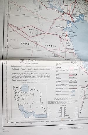
Soft cover. Zustand: Very Good. 4th Edition. Colour printed paper map 85x85cm. Very good, neatly folded with some creasing and marks. This was originally compiled in 1951, revised for major communications and place names in 1956, and printed by AMS dated 9-64. 1:2,500,000. The main features are land transport links, with numerou…s grades of principal or other roads (hard surface, loose surface (all or dry weather), track, trail, tunnel, pass) and rail (various gauges), and water features. The map also highlights the widespread territorial uncertainties at this time. The Iran-Pakistan boundary is labelled "Undemarcated". Also undemarcated is a stretch of the Iran-USSR border at Gasan-Kuli. A note states that "The boundaries of Qatar, the Trucial Principalities, and Muscat and Oman have not been defined and therefore have not been shown on this map". However, all 7 of the Emirates are labelled, along with other key locations on the Arabian side of the Gulf, strategic features including oil pipelines and the Saudi Govt Railroad, and undemarcated boundaries for the Neutral Zones and Iraq-Kuwait. The attribution of Gwadar here to Muscat and Oman became outdated in 1958. This comes with an English-Farsi glossary, and inset index map of Iran's internal boundaries.


