Gesamtpreis (1 Artikel Artikel):
Versandziel:

archibald fullarton (30 Ergebnisse)
Direkt zu den wichtigsten Suchergebnissen
Suchfilter
Produktart
- Alle Product Types
- Bücher (20)
- Magazine & Zeitschriften (Keine weiteren Ergebnisse entsprechen dieser Verfeinerung)
- Comics (Keine weiteren Ergebnisse entsprechen dieser Verfeinerung)
- Noten (Keine weiteren Ergebnisse entsprechen dieser Verfeinerung)
- Kunst, Grafik & Poster (10)
- Fotografien (Keine weiteren Ergebnisse entsprechen dieser Verfeinerung)
- Karten (Keine weiteren Ergebnisse entsprechen dieser Verfeinerung)
- Manuskripte & Papierantiquitäten (Keine weiteren Ergebnisse entsprechen dieser Verfeinerung)
Zustand Mehr dazu
- Neu (Keine weiteren Ergebnisse entsprechen dieser Verfeinerung)
- Wie Neu, Sehr Gut oder Gut Bis Sehr Gut (Keine weiteren Ergebnisse entsprechen dieser Verfeinerung)
- Gut oder Befriedigend (15)
- Ausreichend oder Schlecht (Keine weiteren Ergebnisse entsprechen dieser Verfeinerung)
- Wie beschrieben (15)
Einband
Weitere Eigenschaften
- Erstausgabe (Keine weiteren Ergebnisse entsprechen dieser Verfeinerung)
- Signiert (Keine weiteren Ergebnisse entsprechen dieser Verfeinerung)
- Schutzumschlag (Keine weiteren Ergebnisse entsprechen dieser Verfeinerung)
- Angebotsfoto (18)
Sprache (1)
Gratisversand
- Kostenloser Versand nach USA (Keine weiteren Ergebnisse entsprechen dieser Verfeinerung)
Land des Verkäufers
Verkäuferbewertung
-

Map of Huntingdonshire showing towns, villages, roads and railways.
Verlag: Archibald Fullarton & Co n.d. circa 1840, 1840
Anbieter: PROCTOR / THE ANTIQUE MAP & BOOKSHOP, DORCHESTER, Vereinigtes Königreich
Verbandsmitglied: PBFA
Verkäuferbewertung 5 von 5 Sternen

EUR 20,21
EUR 23,08 Versand
Versand von Vereinigtes Königreich nach USAAnzahl: 1 verfügbar
In den WarenkorbSize 10.5 x 8 inches. With later hand colouring. In portrait. In very good condition. A few faint marks on margins. Also shows Reference to Hundreds.
-

East Riding of Yorkshire with Ainsty Liberty.
Verlag: c. 1840. 8in x 10in., 1840
Anbieter: R.G. Watkins Books and Prints, Ilminster, SOMER, Vereinigtes Königreich
Verkäuferbewertung 5 von 5 Sternen
EUR 11,89
EUR 32,32 Versand
Versand von Vereinigtes Königreich nach USAAnzahl: 1 verfügbar
In den WarenkorbMap, drawn by George Kemp, engraved by James Neele & Co, vignette of Beverley Minster, two vertical folds, slight spotting,
-

ORIGINAL ENGRAVED ANTIQUE MAP OF SURREY
Verlag: Published by Archibald Fullarton & Co. Ca 1843, 1843
Anbieter: PROCTOR / THE ANTIQUE MAP & BOOKSHOP, DORCHESTER, Vereinigtes Königreich
Verbandsmitglied: PBFA
Verkäuferbewertung 5 von 5 Sternen
EUR 26,15
EUR 23,08 Versand
Versand von Vereinigtes Königreich nach USAAnzahl: 1 verfügbar
In den WarenkorbUncoloured Unmounted. In very good condition. With neat center fold. Strong impression. Engraved surface Size 24.5 x 19cm.
-

ORIGINAL ENGRAVED ANTIQUE MAP OF SURREY
Verlag: Published by Archibald Fullarton & Co. Ca 1834, 1834
Anbieter: PROCTOR / THE ANTIQUE MAP & BOOKSHOP, DORCHESTER, Vereinigtes Königreich
Verbandsmitglied: PBFA
Verkäuferbewertung 5 von 5 Sternen
EUR 26,15
EUR 23,08 Versand
Versand von Vereinigtes Königreich nach USAAnzahl: 1 verfügbar
In den WarenkorbHand coloured Unmounted. In very good condition. A few light foxing marks on margins. Two neat folds. Strong impression. Engraved surface Size 24.5 x 19cm.
-
ORIGINAL ENGRAVED MAP OF Middlesex.
Verlag: Published by Fullarton, Archibald & Co Edinburgh 1833, 1833
Anbieter: PROCTOR / THE ANTIQUE MAP & BOOKSHOP, DORCHESTER, Vereinigtes Königreich
Verbandsmitglied: PBFA
Verkäuferbewertung 5 von 5 Sternen
EUR 33,29
EUR 23,08 Versand
Versand von Vereinigtes Königreich nach USAAnzahl: 1 verfügbar
In den WarenkorbOverall size: ca. 8.5 x 11 inches In very good condition. Small tape on both side margins. A few faint foxing spots on margins. Antique engraved copperplate map with original hand colouring. The Map shows the principal roads, rivers, railways and canals.
-

Southern States of Germany comprising Bavaria, Wurtemburg, Baden, Nassau, Darmstadt, Coburg.
Verlag: Edinburgh & London 1856, 1856
Anbieter: Peter Harrington. ABA/ ILAB., London, Vereinigtes Königreich
Verbandsmitglied: ABA ILAB PBFA
Verkäuferbewertung 5 von 5 Sternen
EUR 35,66
EUR 25,39 Versand
Versand von Vereinigtes Königreich nach USAAnzahl: 1 verfügbar
In den WarenkorbThe map includes five insets with the city plans of Nuremberg, Munich, Mayence, Frankfurt and the State of Frankfurt. Copper engraving. Hand coloured. Size: 260 x 325 mm Very good condition.
-

Northern & Central Germany; Map & City Plans (1874 Engraving)
Verlag: Fullarton, UK, 1874
Anbieter: Maynard & Bradley, Leicester, Vereinigtes Königreich
Verkäuferbewertung 5 von 5 Sternen
EUR 71,27
EUR 25,33 Versand
Versand von Vereinigtes Königreich nach USAAnzahl: 1 verfügbar
In den WarenkorbSoftcover. Zustand: Very Good. 1874. A largely presentable engraving, including plans of Dresden, Leipzig and Hamburg. Lightly browned around the outer edges and with a few damp marks and some small nicks and creases repaired and reinforced with conservation tape, but otherwise unmarked with no major encroachments onto the printed images, and with text remaining clear throughout. Why on Amazon do most sellers not describe their actual book? Buy with confidence and support a genuine Independent Bricks & Mortar Real Bookshop. We are Maynard & Bradley CAMBO & PBFA(now lapsed) members here in Leicester City Centre. Size: 325 x 480 mm. 1. Item Type: Book. Quantity Available: 1. Shipped Weight: Under 500 grams. Category: Geography & Maps; Britain/UK; 19th century; Inventory No: 47438.
-

Southern Germany; Map & City Plans (1874 Engraving)
Verlag: Fullarton, UK, 1874
Anbieter: Maynard & Bradley, Leicester, Vereinigtes Königreich
Verkäuferbewertung 5 von 5 Sternen
EUR 71,27
EUR 25,33 Versand
Versand von Vereinigtes Königreich nach USAAnzahl: 1 verfügbar
In den WarenkorbSoftcover. Zustand: Very Good. 1874. A largely presentable engraving, including plans of Frankfurt, Munich & Nuremberg. Lightly browned around the outer edges and with a few small nicks and creases repaired and reinforced with conservation tape, but otherwise unmarked with no major encroachments onto the printed images, and with text remaining clear throughout. Why on Amazon do most sellers not describe their actual book? Buy with confidence and support a genuine Independent Bricks & Mortar Real Bookshop. We are Maynard & Bradley CAMBO & PBFA(now lapsed) members here in Leicester City Centre. Size: 325 x 480 mm. 1. Item Type: Book. Quantity Available: 1. Shipped Weight: Under 500 grams. Category: Geography & Maps; Britain/UK; 19th century; Inventory No: 47437.
-

French Ports & Harbours, Plan of Paris (1874 Engraving)
Verlag: Fullarton, UK, 1874
Anbieter: Maynard & Bradley, Leicester, Vereinigtes Königreich
Verkäuferbewertung 5 von 5 Sternen
EUR 79,59
EUR 25,33 Versand
Versand von Vereinigtes Königreich nach USAAnzahl: 1 verfügbar
In den WarenkorbSoftcover. Zustand: Very Good. 1874. A largely very presentable engraving, including plans of ports at Brest, Boulogne, Marseilles, Toulon, Chaerbourg and Le Havre, and a city plan of Paris. Lightly browned around the outer edges and with a few small nicks and creases repaired and reinforced with conservation tape, but otherwise unmarked with no major encroachments onto the printed images, and with text remaining clear throughout. Why on Amazon do most sellers not describe their actual book? Buy with confidence and support a genuine Independent Bricks & Mortar Real Bookshop. We are Maynard & Bradley CAMBO & PBFA(now lapsed) members here in Leicester City Centre. Size: 325 x 480 mm. 1. Item Type: Book. Quantity Available: 1. Shipped Weight: Under 500 grams. Category: Geography & Maps; Britain/UK; 19th century; Inventory No: 47278.
-
Southern States of Germany comprising Bavaria, Wurtemburg, Baden, Nassau, Darmstadt, Coburg etc.
Anbieter: Antiquariat Lang, Rennerod, Deutschland
Verkäuferbewertung 4 von 5 Sternen

Kolorierte Orig.-Kupferstich-Karte. London & Edinburgh: A. Fullarton, (1856). - 6-Segment-Karte: 46 x 30 unter Glas in dunkelbraun-cremefarbenem Passepartout und goldgerahmtem, dunkelbraunem Echtholzrahmen: 61,5 x 46. * Die sechsteilige Karte von Süddeutschland in der Mitte des 19. Jahrhunderts zeigtdie damaligen Kleinstaaten Bayern, Württemberg, Baden, Nassau, Darmstadt und Coburg sowie 5 Segmente mit den Stadtplänen von Nürnberg, München, Mainz, Frankfurt a. M. sowie das Umland von Frankfurt. - A map of the Southern German states in the middle of 19. century, showing Bavaria, Wurtemburg, Baden, Nassau, Darmstadt and Coburg. There are four insets of the city plans of Nuremberg, Munich, Mayence, Frankfort and the 'State of Frankfort'. Published in The Royal Illustrated Atlas of Modern Geography. - Sehr gut erhalten / Fine condition !
-
Map of Huntingdonshire
Anbieter: St Marys Books And Prints, Stamford, Vereinigtes Königreich
Verkäuferbewertung 4 von 5 Sternen
EUR 53,49
EUR 23,83 Versand
Versand von Vereinigtes Königreich nach USAAnzahl: 1 verfügbar
In den WarenkorbHardback. c 1843 Hand coloured Mounted framed and glazed in Hogarth frame Map Measures approx 725 inches x 95 inches Framed measurements are approx 1175 inches x 1475 inches A clean bright map in very nice condition. book.
-

Durham
Erscheinungsdatum: 1833
Anbieter: Hornseys, Ripon, Vereinigtes Königreich
Verbandsmitglied: PBFA
Verkäuferbewertung 5 von 5 Sternen
EUR 29,72
EUR 28,85 Versand
Versand von Vereinigtes Königreich nach USAAnzahl: 1 verfügbar
In den WarenkorbNo Binding. Zustand: Good. Original copper engraving. Date: c.1833. Sheet size: 31.8cm x 26cm. Later but not modern hand-colouring. Blank to the reverse. Age staining which is mainly confined to the margins and to the reverse. In good condition.
-

Gazetteer/Scotland,anno 1845,Fullarton, 2 Vols.
Verlag: Fullarton Archibald, Edinburgh
Anbieter: Hammelburger Antiquariat, Hammelburg, Deutschland
Verkäuferbewertung 4 von 5 Sternen
Hardcover. Zustand: very good. Gazetteer/Scotland,anno 1845,Fullarton, 2 Vols. "THE TOPOGRAPHICAL, STATISTICAL, AND HISTORICAL GAZETTEER OF SCOTLAND, EDINBURGH; LONDON; AND DUBLIN; A. FULLARTON AND CO. 1845" A. Fullarton, anno 1845, 2 Vols, Volume first A-H, second I-Z, each 27x20 cm., original binding, No.1: VI, IXIV, 814 pages, No.2: II, 852 pages. With one folio-map of Scotland, 16 steelengravings and numerous woodcuts within the pagination. Contemporary binding, only little foxed.
-
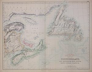
British North America, Sheet 1, East. Newfoundland, New Brunswick, Nova Scoria, Prince Edward Island etc.
Verlag: Fullarton, Archibald, Edinburgh, 1862
Anbieter: Argosy Book Store, ABAA, ILAB, New York, NY, USA
Verkäuferbewertung 5 von 5 Sternen
unbound. Map. Color engraving. Image measures 16" x 20 3/4". 1862. This is a wonderful map of the East Coast of Canada, covering Nova Scotia, New Brunswick, Newfoundland and Prince Edwards Island. The two islands (Nova Scotia and Newfoundland) as well as Prince Edward Island, are shown as they are situated off the coasts of New Brunswick and Labrador. Each is abundantly labeled with the names of cities, ports, rivers, mountains, and most importantly, bays and harbors, as these sites were the keys to the economic prosperity with the 19th-century market. From Fullarton's "Royal Illustrated Atlas", considered the last highly decorative atlas published in England. Beautifully engraved and colored with a mixture of printed color and hand color. Engraved by J. Hugh Johnson. Map is in good condition with small chips and tears along edges and centerfold. Archibald Fullarton was a prominent Glasgow-based publisher who worked under the firm of A. Fullarton & Co. This is a fine example of his work.
-
Scenery and Animated Life Kamtchatka and Kirghiz Steppes
Verlag: A. Fullarton & Co. c.1850, London & Edinburgh, 1850
Anbieter: Alexandre Antique Prints, Maps & Books, Toronto, ON, Kanada
Verkäuferbewertung 5 von 5 Sternen
Kunst / Grafik / Poster
Zustand: Very Good. Image Size : , Platemark Size : , Paper Size : 264x193 (mm), 10.39x7.60 (Inches), Hand Colored, Lithograph.
-
Scenery and Animated Life Madeira and Azores II.
Verlag: A. Fullarton & Co. c.1850, London & Edinburgh, 1850
Anbieter: Alexandre Antique Prints, Maps & Books, Toronto, ON, Kanada
Verkäuferbewertung 5 von 5 Sternen
Kunst / Grafik / Poster
Zustand: Very Good. Image Size : , Platemark Size : , Paper Size : 264x188 (mm), 10.39x7.40 (Inches), Hand Colored, Lithograph.
-
Scenery and Animated Life West Coast of South America II.
Verlag: A. Fullarton & Co. c.1850, London & Edinburgh, 1850
Anbieter: Alexandre Antique Prints, Maps & Books, Toronto, ON, Kanada
Verkäuferbewertung 5 von 5 Sternen
Kunst / Grafik / Poster
Zustand: Very Good. Image Size : , Platemark Size : , Paper Size : 265x198 (mm), 10.43x7.80 (Inches), Hand Colored, Lithograph.
-
Scenery and Animated Life West Coast of South America I.
Verlag: A. Fullarton & Co. c.1850, London & Edinburgh, 1850
Anbieter: Alexandre Antique Prints, Maps & Books, Toronto, ON, Kanada
Verkäuferbewertung 5 von 5 Sternen
Kunst / Grafik / Poster
Zustand: Very Good. Image Size : , Platemark Size : , Paper Size : 264x191 (mm), 10.39x7.52 (Inches), Hand Colored, Lithograph.
-
Scenery and Animated Life Guayana II
Verlag: A. Fullarton & Co. c.1850, London, 1850
Anbieter: Alexandre Antique Prints, Maps & Books, Toronto, ON, Kanada
Verkäuferbewertung 5 von 5 Sternen
Kunst / Grafik / Poster
Zustand: Very Good. A scenery of Guyana., Image Size : , Platemark Size : , Paper Size : 197x263 (mm), 7.76x10.35 (Inches), Hand Colored, Lithograph.
-

Oceania, or Islands in the Pacific Ocean, on Mercators Projection, comprising Polynesia, Malaysia and Australia.
Verlag: London & Edinburgh, 1874. 400 x 500mm (15ľ x 19ľ inches)., 1874
Anbieter: Tooley, Adams & Co., Wallingford, OXON, Vereinigtes Königreich
Verkäuferbewertung 4 von 5 Sternen
EUR 71,33
EUR 42,88 Versand
Versand von Vereinigtes Königreich nach USAAnzahl: 1 verfügbar
In den WarenkorbOriginal coloured lithograph; short centrefold split at lower margin (repaired), otherwise a fine example. The Pacific Ocean, with all the islands individually marked. From 'The Royal Illustrated Atlas of Modern Geography'.
-
Scenery and Animated Life West Indies I
Verlag: A. Fullarton & Co. c.1850, London & Edinburgh, 1850
Anbieter: Alexandre Antique Prints, Maps & Books, Toronto, ON, Kanada
Verkäuferbewertung 5 von 5 Sternen
Kunst / Grafik / Poster
Zustand: Very Good. Image Size : , Platemark Size : , Paper Size : 265x197 (mm), 10.43x7.76 (Inches), Hand Colored, Lithograph.
-
Scenery and Animated life Ceylon I
Verlag: A. Fullarton & Co. c.1850, London, 1850
Anbieter: Alexandre Antique Prints, Maps & Books, Toronto, ON, Kanada
Verkäuferbewertung 5 von 5 Sternen
Kunst / Grafik / Poster
Zustand: Very Good. Image Size : , Platemark Size : , Paper Size : 265x198 (mm), 10.43x7.80 (Inches), Hand Colored, Lithograph.
-
Scenery and Animated Life Borneo
Verlag: A. Fullarton & Co. c.1850, London, 1850
Anbieter: Alexandre Antique Prints, Maps & Books, Toronto, ON, Kanada
Verkäuferbewertung 5 von 5 Sternen
Kunst / Grafik / Poster
Zustand: Very Good. Image Size : , Platemark Size : , Paper Size : 165x198 (mm), 6.50x7.80 (Inches), Hand Colored, Lithograph.
-
Scenery and Animated Life Iceland
Verlag: A. Fullarton & Co. c.1850, London, 1850
Anbieter: Alexandre Antique Prints, Maps & Books, Toronto, ON, Kanada
Verkäuferbewertung 5 von 5 Sternen
Kunst / Grafik / Poster
Zustand: Very Good. Image Size : , Platemark Size : , Paper Size : 258x194 (mm), 10.16x7.64 (Inches), Hand Colored, Lithograph.
-
Scenery and Animated Life Ceylon II
Verlag: A. Fullarton & Co. c.1850, London, 1850
Anbieter: Alexandre Antique Prints, Maps & Books, Toronto, ON, Kanada
Verkäuferbewertung 5 von 5 Sternen
Kunst / Grafik / Poster
Zustand: Very Good. Image Size : , Platemark Size : , Paper Size : 265x282 (mm), 10.43x11.10 (Inches), Hand Colored, Lithograph.
-

Devonshire.
Verlag: Glasgow: The Parliamentary Gazetteer, c.1840, 1840
Anbieter: Peter Harrington. ABA/ ILAB., London, Vereinigtes Königreich
Verbandsmitglied: ABA ILAB PBFA
Verkäuferbewertung 5 von 5 Sternen
EUR 112,93
EUR 25,39 Versand
Versand von Vereinigtes Königreich nach USAAnzahl: 1 verfügbar
In den WarenkorbAn attractive map of the county embellished with a vignette view of Exeter Cathedral. Scale, compass rose and list of hundreds. Copper engraving. Hand coloured. Size: 256 x 308 mm Very good condition.
-

Glocestershire.
Verlag: Glasgow: The Parliamentary Gazetteer, c.1840, 1840
Anbieter: Peter Harrington. ABA/ ILAB., London, Vereinigtes Königreich
Verbandsmitglied: ABA ILAB PBFA
Verkäuferbewertung 5 von 5 Sternen
EUR 112,93
EUR 25,39 Versand
Versand von Vereinigtes Königreich nach USAAnzahl: 1 verfügbar
In den WarenkorbAn attractive map of the county embellished with a vignette view of Gloucester Cathedral. Scale, compass rose and list of hundreds. Copper engraving. Hand coloured. Size: 310 x 258 mm Very good condition.
-

Cheshire.
Verlag: Glasgow: The Parliamentary Gazetteer, c.1840, 1840
Anbieter: Peter Harrington. ABA/ ILAB., London, Vereinigtes Königreich
Verbandsmitglied: ABA ILAB PBFA
Verkäuferbewertung 5 von 5 Sternen
EUR 112,93
EUR 25,39 Versand
Versand von Vereinigtes Königreich nach USAAnzahl: 1 verfügbar
In den WarenkorbAn attractive map of the county embellished with a vignette view of Eaton Hall, South of Eccleston. Scale, compass rose and list of hundreds. Copper engraving. Hand coloured. Size: 258 x 324 mm Very good condition.
-

Portuguese Islands in the Atlantic Ocean.
Verlag: London & Edinburgh, 1874. 460 x 305mm (18 x 12 inches)., 1874
Anbieter: Tooley, Adams & Co., Wallingford, OXON, Vereinigtes Königreich
Verkäuferbewertung 4 von 5 Sternen
EUR 95,10
EUR 42,88 Versand
Versand von Vereinigtes Königreich nach USAAnzahl: 1 verfügbar
In den WarenkorbOriginal coloured lithograph; minor spotting and light age-toning to margins, otherwise very good condition. Two maps on one sheet, one of the Islands in the Atlantic, including the Azores, Terceira, San Miguel, Pico, Fayal and others, the lower one the Island of Madeira. From 'The Royal Illustrated Atlas of Modern Geography'.
-

West Riding of Yorkshire.
Verlag: Glasgow: The Parliamentary Gazetteer, c.1840, 1840
Anbieter: Peter Harrington. ABA/ ILAB., London, Vereinigtes Königreich
Verbandsmitglied: ABA ILAB PBFA
Verkäuferbewertung 5 von 5 Sternen
EUR 142,65
EUR 25,39 Versand
Versand von Vereinigtes Königreich nach USAAnzahl: 1 verfügbar
In den WarenkorbAn attractive map of the county embellished with a vignette view of Proprietory School Wakefield. Scale, compass rose and list of hundreds. Copper engraving. Hand coloured. Size: 258 x 316 mm Very good condition.