Gesamtpreis (1 Artikel Artikel):
Versandziel:

alkemade schelling (11 Ergebnisse)
Direkt zu den wichtigsten Suchergebnissen
Suchfilter
Produktart
- Alle Product Types
- Bücher (11)
- Magazine & Zeitschriften (Keine weiteren Ergebnisse entsprechen dieser Verfeinerung)
- Comics (Keine weiteren Ergebnisse entsprechen dieser Verfeinerung)
- Noten (Keine weiteren Ergebnisse entsprechen dieser Verfeinerung)
- Kunst, Grafik & Poster (Keine weiteren Ergebnisse entsprechen dieser Verfeinerung)
- Fotografien (Keine weiteren Ergebnisse entsprechen dieser Verfeinerung)
- Karten (Keine weiteren Ergebnisse entsprechen dieser Verfeinerung)
- Manuskripte & Papierantiquitäten (Keine weiteren Ergebnisse entsprechen dieser Verfeinerung)
Zustand Mehr dazu
- Neu (Keine weiteren Ergebnisse entsprechen dieser Verfeinerung)
- Wie Neu, Sehr Gut oder Gut Bis Sehr Gut (Keine weiteren Ergebnisse entsprechen dieser Verfeinerung)
- Gut oder Befriedigend (Keine weiteren Ergebnisse entsprechen dieser Verfeinerung)
- Ausreichend oder Schlecht (Keine weiteren Ergebnisse entsprechen dieser Verfeinerung)
- Wie beschrieben (11)
Einband
- alle Einbände
- Hardcover (1)
- Softcover (Keine weiteren Ergebnisse entsprechen dieser Verfeinerung)
Weitere Eigenschaften
- Erstausgabe (1)
- Signiert (1)
- Schutzumschlag (Keine weiteren Ergebnisse entsprechen dieser Verfeinerung)
- Angebotsfoto (7)
Sprache (1)
Preis
- Beliebiger Preis
- Weniger als EUR 20 (Keine weiteren Ergebnisse entsprechen dieser Verfeinerung)
- EUR 20 bis EUR 45 (Keine weiteren Ergebnisse entsprechen dieser Verfeinerung)
- Mehr als EUR 45
Gratisversand
- Kostenloser Versand nach USA (Keine weiteren Ergebnisse entsprechen dieser Verfeinerung)
Land des Verkäufers
Verkäuferbewertung
-
Beschryving van de stad Briele, en den Lande van Voorn, behelzende, I. De beschryving zelf. II. De historie, genealogie, en successie van de heeren, en vrouwen van Voorn . III. De politike regering, nevens de regten, . mitsgaders de regtspleging . omtrent het jaar MCCCC in de stad Briel, en 't Land van Voorn in gebruik geweest zynde. IV. De privilegien, octroyen . betreffende de stad Briele, en den Lande van Voorn .
Verlag: Philippus Losel,, Rotterdam,, 1729
Anbieter: Antiquariaat FORUM BV, Houten, Niederlande
Verkäuferbewertung 5 von 5 Sternen

Signiert
EUR 3.500,00
EUR 25,00 Versand
Versand von Niederlande nach USAAnzahl: 1 verfügbar
In den Warenkorb2 parts in 1 volume. Presentation copy on large paper of the first and only edition of a topographical and historical description of Den Briel on the island of Voorne, illustrated with large, folding maps. The present copy has been bound by the so-called Stag Bindery (active 1693-1743/1758), the most important bindery in Rotterdam in the 18th century. Several other copies of the work with identical bindings are known. According to Storm van Leeuwen they were commissioned by the publisher and "are undoubtedly presentation copies for members of the Den Briel magistracy or persons connected with them." Cornelis van Alkemade (1654-1737) and his son-in-law Pieter van der Schelling (1691-1751) shared a passion for collecting coins, seals, official documents, autographs and books. Van Alkemade also copied many historical documents. The present work reflects his collection on Den Briel, the city that will always be remembered for being the first to be captured by the Dutch in the 80 Years' War in 1572. Van Alkemade gives the usual historical and geographical description, which describes among other things the successive growth of the polders on the island of Voorne, and chronicles the history of the noble family that governed it. The 3 large folding maps show different parts of Voorne, with coats of arms and embellished cartouches along the borders or in the corners. The maps were executed by H. v.d. Dyck, while three other names are mentioned, including Jan Luyken ("I. Luiken Fecit cum Aqua Forti"), who executed and probably also drew the pictorial decoration. The first map is dated 1701. They are the three general maps from Voorne. Caert-Boeck van alle de Dorpen, en Polders Gelegen inden Lande van Oost ende West Voorne, mitsgaders Over Flacquee Resorteerende onder 't Comptoir der Verpondingen 's Lands van Voorne. The fourth map, depicting the southwestern part of the province of South Holland, is found in the second part. It is a later addition, published by Tirion in Amsterdam in 1748.The present work is especially interesting because it contains the first published text of Jan Matthijsen's famous Rechtsboek of the city of Den Briel. It was probably written between 1400 and 1423, and is one of the oldest and most important sources of for the study of Dutch law, especially in the area of procedural law. The second part of the work comprises a collection of privileges and charters.With the bookplate of Jan Willem Six van Vromade (1872-1936) mounted on the front pastedown, the stamp of H. D. Pfann (dates unknown) below, and remnants of a paper label at the foot. The edges and corners of the boards are scuffed, the joints are cracked, but the structural integrity of the binding is still intact, a tear at the head of the spine, lacking the headband. The end paper have been replaced, leaves are slightly browned and foxed, a brown stain in the lower margin first 60 pages of part 2. Otherwise a large paper copy in good condition.l Donkersloot-de Vrij 247; Van Eeghen Collectie 47; Van Eeghen & V.d. Kellen 473; Nijhoff & V. Hattum 2; STCN 20446403X; cf. Storm van Leeuwen, Dutch decorated bookbinding in the 18th century, vol. IIa, pp. 432-446 (for the binding). Contemporary gold-tooled mottled calf by the so-called Stag Bindery in Rotterdam, sewn on 6 supports with the corresponding raised bands on the spine, a black morocco author and title label on the spine lettered in gold, the coat of arms of Den Briel in the centre of both boards, surrounded by two ornamental borders, gold-tooled board edges, mottled edges. With the title page printed in red and black with an engraved printer's device, a double-page plan of Den Briel, 3 folding engraved maps of different parts of Voorne (each ca. 50 x 70.5 cm), and an additional folding map (33 x 38 cm) of the southwestern part of South Holland. Pages: [28], 1-224, [8], 225-376; [8], 1-306, [20] pp.
-

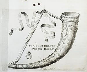
Nederlands Displegtigheden, vertoonende de plegtide gebruiken aan den dis, in hed houden van Maaltyden, en het Drinken de Gezondheden, onder de oude Batavieren, en Vorsten, Graaven, Edelen, en andere Ingetezeden der Niederlande. BAND 1 (von 3). Rotterdam, Phillipps Losel, 1732. Mit gestochenem Frontispiz u.1 gest.Tafel (Goude Bruilofts Pennig), 64 Bl., 562 S., blindgepr.OPgt.-Band der Zeit über 6 Bünden mit 2 goldgepr.RSchildchen, etw.gespreitzt, innen gering gebräunt; gutes Expl. - Über die Tafelgepflogenheiten u.feierlichen Bräuche bei Tisch von der Zeit der alten Bataver bis hin zu Gebräuchen von Fürsten, Grafen u.Adligen des 18.Jhdt. Wichtige Quelle für die Erforschung der niederländ.Gastronomiegeschichte und Ethnologie.
Anbieter: Wissenschaftliches Antiquariat Mayrhofer, Pürbach, Österreich
Verkäuferbewertung 5 von 5 Sternen
Nederlands Displegtigheden, vertoonende de plegtide gebruiken aan den dis, in hed houden van Maaltyden, en het Drinken de Gezondheden, onder de oude Batavieren, en Vorsten, Graaven, Edelen, en andere Ingetezeden der Niederlande. BAND 1 (von 3). Rotterdam, Phillipps Losel, 1732. Mit gestochenem Frontispiz u.1 gest.Tafel (Goude Bruilofts Pennig), 64 Bl., 562 S., blindgepr.OPgt.-Band der Zeit über 6 Bünden mit 2 goldgepr.RSchildchen, etw.gespreitzt, innen gering gebräunt; gutes Expl. - Über die Tafelgepflogenheiten u.feierlichen Bräuche bei Tisch von der Zeit der alten Bataver bis hin zu Gebräuchen von Fürsten, Grafen u.Adligen des 18.Jhdt. Wichtige Quelle für die Erforschung der niederländ.Gastronomiegeschichte und Ethnologie.
-
Het Noortwiikze Schutters-hof en Doel-broederschap uit des lands jaarboeken en hun eige gedenkstukken en bewiisen getroulijk beschreven.
Anbieter: Antiquariaat Brinkman, since 1954 / ILAB, Amsterdam, Niederlande
Verkäuferbewertung 5 von 5 Sternen
Folio. 168 eenzijdig beschreven pp. in fotokopie. Linnen.
-
Nederlands displegtigheden. Vertoonende de plegtige gebruiken aan den dis, in het houden van maaltyden, en het drinken der gezondheden, onder de oude Batavieren, en vorsten, graaven, edelen, en andere ingezetenen der Nederlanden, weleer gebruikelyk, nevens den oorsprongk dezer gewoontens, en der zelver overeenkomst met die van andere volken. Door K. van Alkemade, en Mr. P. van der Schelling.
Verlag: Rotterdam, Philippus Losel 1732-1735., 1735
Anbieter: Antiquariat Haufe & Lutz, Karlsruhe, BW, Deutschland
Verkäuferbewertung 5 von 5 Sternen
Erstausgabe
3 Bände. 8°. [68] Bl., 562 S.; Titel, 557, (61) S.; [46] Bl., 612 S., [27] Bl. mit 2 gestoch. Frontisp. u. 15 (5 gefalt.) Kupfertafeln von F. v. Bleyswyck. Prgt. d. Zt. mit handschr. Rückentitel. Cagle 1075. Graesse I, 78. Oberlé, Fastes 485. Muller 418. Waller 45. Nicht bei Bitting, Simon u. Vicaire. - Erste Ausgabe. - Wichtiges Werk über die Trinksitten in den Niederlanden. Die schönen Kupfer zeigen Trinkgefässe (Trinkhörner, Krüge etc.). - St.a.T., eine Tafel im äußeren Rand knapp beschnitten (geringer Bildverlust), sonst sehr gutes sauberes Exemplar. - Eerste druk. - Belangrijk werk over drinkgewoonten in Nederland. De prachtige gravures tonen drinkgerei (drinkhoorns, kruiken etc.). - St.a.T., één plaat iets bijgesneden in buitenmarge (klein verlies van afbeelding), verder zeer goed net exemplaar. Sprache: niederländisch.
-
Beschryving van de stad Briele, en den lande van Voorn, behelzende, I. De beschryving zelf. II. De historie, genealogie, en successie van de heeren, en vrouwen van Voorn . III. De politike regering, nevens de regten, . mitsgaders de regtspleging . omtrent het jaar MCCCC in de stad Briel, en 't land van Voorn in gebruik geweest zynde. IV. De privilegien, octroyen . betreffende de stad Briele, en den lande van Voorn; . Te samen gesteld, en beschreven door Kornelis van Alkemade, en met eenige hoofddelen, byvoegselen, en aanteekeningen vermeerderd door Mr. P. van der Schelling.
Verlag: Philippus Losel,, Rotterdam,, 1729
Anbieter: Antiquariaat FORUM BV, Houten, Niederlande
Verkäuferbewertung 5 von 5 Sternen
EUR 2.500,00
EUR 25,00 Versand
Versand von Niederlande nach USAAnzahl: 1 verfügbar
In den Warenkorb2 parts in 1 volume. First and only edition of a topographical and historical description of Den Briel on the island of Voorne. Cornelis van Alkemade (1654-1737) and his son-in-law Pieter van der Schelling (1691-1751) shared a passion for collecting coins, seals, official documents, autographs and books. Van Alkemade also copied many historical documents. The present work reflects his collection on Den Briel, the city that will always be remembered for being the first to be captured by the Dutch in the 80 Years' War in 1572. Van Alkemade gives the usual historical and geographical description, which describes among other things the successive growth of the polders on the island of Voorne, and chronicles the history of the noble family that governed Voorne. The present work is especially interesting because it contains the first published text of Jan Matthijsen's famous Rechtsboek of the city of Den Briel. It was probably written between 1400 and 1423, and is one of the oldest and most important sources of for the study of Dutch law.Maps with tears in some folds, a few leaves with some names checked off and a water stain in the upper right corner of the last 25 leaves. The blind-stamped centrepiece on the front board has cut through the vellum at the upper right edge. In good condition.l Donkersloot-de Vrij 247; V. Eeghen & V.d. Kellen 473; Klaversma & Hannema 47. Contemporary blind-tooled vellum sewn on 7 cords (each board with a scrollwork centrepiece in a panel design of double fillets), manuscript title on spine, red sprinkled edges. With title-page printed in red and black with engraved publisher's device (including printers at a press and compositors at case), a double-page engraved plan of Den Briel and 3 folding engraved maps of different parts of Voorne (each ca. 50 x 70.5 cm). Pages: [28], 224, [8], 225-376; [8], 306, [20] pp.
-
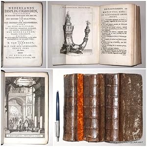
Nederlands displegtigheden, vertoonende de plegtige gebruiken aan den dis, in het houden van maaltyden, en het drinken der gezondheden, onder de oude Batavieren, en vorsten, graaven, edelen, en andere ingezetenen der Nederlanden, weleer gebruikelyk (.).
Verlag: Rotterdam, Philippus Losel, 1732-1735., 1735
Anbieter: Charbo's Antiquariaat, Amsterdam, Niederlande
Verkäuferbewertung 5 von 5 Sternen
Zustand: Redelijk ex. 3 delen. (CXXXIV)+562;(III)+557+(61); (XC)+612+(54) pp. Compleet met 2 identieke gegrav. titels & 17 gravures op 15 platen. Gebonden. Half leer uit de tijd. (Banden wat geschaafd, papier op platten van 2e deel afwijkend van andere delen; rugeinden iets besch.; van het 2e deel zijn de eerste 150 pp. in de benedenmarge wat watervlekkig). * Waller, Populaire boeken, 45; Muller, Populaire prozaschrijvers, 418.
-

Rotterdam, Philippus Losel, 1732, 2 volumes in contemporary full parchment spitsel bindings, with handwritten titles on spine and blue and red sprinkled edges, (I)[132]+562 (II)557+[6] pp., parchment with some stains and a tear on the spine of volume 2, the endpapers in front and back are crinkled and folded (titlepages intact), the inside coverboards are exposed, a page is coming loose in the preface of volume 1, the bookblocks are hardly stained and show clear printwork. With an engraved titlepage in both volumes (F. van Bleyswyck inven. & fec.). In volume 1 there are two small engravings depicting a "goude bruilofts penning", volume 2 has 11 engravings (F. van Bleyswyck fecit) of which three can fold out. l Two volumes (of three).
-
Beschryving van de stad Brielle en den lande van Voorn, 2 delen in één band, Rotterdam, Ph. Losel, 1729.
Anbieter: Antiquariaat Arine van der Steur / ILAB, Den Haag, Niederlande
Verkäuferbewertung 5 von 5 Sternen
Folio, gebonden in geheel leren band uit de tijd, (28) 376 (8) 306 (17) pag. Exemplaar zonder de vier kaarten, eerste en laatste pagina's met waterschade, doch vakkundig gerepareerd.
-
Rotterdam, Ph. Losel, 1732-1735. 3 volumes in full contemporary vellum. 562+557+612 pag. Illustrated with 2 frontispices and 15 engravings. Beautiful complete set.B0302.
-

EUR 2.300,00
EUR 31,80 Versand
Versand von Niederlande nach USAAnzahl: 1 verfügbar
In den WarenkorbFolio, moderne leren band, (28)+376+(8)+306+(17) pag. Geillustreerd met een plattegrond van Brielle en drie grote, oud-handgekleurde kaarten van Oost-Voorne, Zuid-Voorne en West-Voorne. B0454.
-

EUR 1.840,00
EUR 31,80 Versand
Versand von Niederlande nach USAAnzahl: 1 verfügbar
In den WarenkorbFolio, half leren band uit de tijd, (28)+376+(8)+306+(17) pag. Geillustreerd met een plattegrond van Brielle en drie grote kaarten van Oost-Voorne, Zuid-Voorne en West-Voorne. De kaarten hier en daar gerepareerd, sporen van een boekenworm in de marge. B0898.