Gesamtpreis (1 Artikel Artikel):
Versandziel:

alex keith johnston (62 Ergebnisse)
Direkt zu den wichtigsten Suchergebnissen
Suchfilter
Produktart
- Alle Product Types
- Bücher (62)
- Magazine & Zeitschriften (Keine weiteren Ergebnisse entsprechen dieser Verfeinerung)
- Comics (Keine weiteren Ergebnisse entsprechen dieser Verfeinerung)
- Noten (Keine weiteren Ergebnisse entsprechen dieser Verfeinerung)
- Kunst, Grafik & Poster (Keine weiteren Ergebnisse entsprechen dieser Verfeinerung)
- Fotografien (Keine weiteren Ergebnisse entsprechen dieser Verfeinerung)
- Karten (Keine weiteren Ergebnisse entsprechen dieser Verfeinerung)
- Manuskripte & Papierantiquitäten (Keine weiteren Ergebnisse entsprechen dieser Verfeinerung)
Zustand Mehr dazu
- Neu (4)
- Wie Neu, Sehr Gut oder Gut Bis Sehr Gut (Keine weiteren Ergebnisse entsprechen dieser Verfeinerung)
- Gut oder Befriedigend (8)
- Ausreichend oder Schlecht (1)
- Wie beschrieben (49)
Einband
Weitere Eigenschaften
- Erstausgabe (Keine weiteren Ergebnisse entsprechen dieser Verfeinerung)
- Signiert (Keine weiteren Ergebnisse entsprechen dieser Verfeinerung)
- Schutzumschlag (Keine weiteren Ergebnisse entsprechen dieser Verfeinerung)
- Angebotsfoto (21)
Sprache (2)
Gratisversand
Land des Verkäufers
Verkäuferbewertung
-

The school atlas of physical geography illustrated in a series: The elementary facts of geology, hydrography, meteorology and natural history
Anbieter: Ria Christie Collections, Uxbridge, Vereinigtes Königreich
Verkäuferbewertung 5 von 5 Sternen

EUR 24,69
EUR 13,85 Versand
Versand von Vereinigtes Königreich nach USAAnzahl: Mehr als 20 verfügbar
In den WarenkorbZustand: New. In.
-

School Atlas of Physical Geography
Anbieter: Ria Christie Collections, Uxbridge, Vereinigtes Königreich
Verkäuferbewertung 5 von 5 Sternen
EUR 25,12
EUR 13,85 Versand
Versand von Vereinigtes Königreich nach USAAnzahl: Mehr als 20 verfügbar
In den WarenkorbZustand: New. In.
-
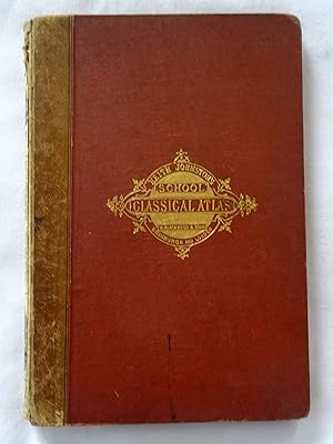
School Atlas of Classical Geography Comprising in Twenty Plates Maps and Plans of All the Important Countries and Localities Referred to by Classical Authors,
Sprache: Englisch
Verlag: William Blackwood & Sons, London, England,, 1874
Anbieter: Tony Hutchinson, Seale, Vereinigtes Königreich
Verkäuferbewertung 5 von 5 Sternen
EUR 52,38
EUR 24,27 Versand
Versand von Vereinigtes Königreich nach USAAnzahl: 1 verfügbar
In den WarenkorbHardcover. Zustand: Good. New & Enlarged Edition. 23 hinged in double page maps +36pp index. Still well bound but missing leather of spine, foxing to end pages but not maps, interior in nice clean condition. Owner's name and 1876 date at top of title page.
-

Dictionary of geography, descriptive, physical, statistical, and historical; forming a complete general gazetteer of the world, vol I: Aa - Le
Verlag: Longman, Brown, Green & Longmans, London, 1855
Anbieter: Cotswold Internet Books, Cheltenham, Vereinigtes Königreich
Verkäuferbewertung 5 von 5 Sternen
EUR 23,57
EUR 16,18 Versand
Versand von Vereinigtes Königreich nach USAAnzahl: 1 verfügbar
In den Warenkorb2nd ed. Bound in half-leather with marbled boards. Pages clean; front board detached; leather on spine badly deteriorated, & worn at board corners; paper on boards scuffed; would benefit from rebinding. Last page end mid-sentence Used - Acceptable. Poor hardback.
-
Taschenbuch. Zustand: Neu. The school atlas of physical geography illustrated in a series | The elementary facts of geology, hydrography, meteorology and natural history | Alex. Keith Johnston | Taschenbuch | 132 S. | Englisch | 2016 | hansebooks | EAN 9783742846181 | Verantwortliche Person für die EU: Hansebooks GmbH, Trakehner Weg 52, 22844 Norderstedt, gb[at]hansebooks[dot]com | Anbieter: preigu.
-

Taschenbuch. Zustand: Neu. School Atlas of Physical Geography | Alex Keith Johnston | Taschenbuch | Kartoniert / Broschiert | Englisch | 2022 | hansebooks | EAN 9783348072380 | Verantwortliche Person für die EU: Hansebooks GmbH, Trakehner Weg 52, 22844 Norderstedt, gb[at]hansebooks[dot]com | Anbieter: preigu.
-

School Atlas of Classical Geography Comprising in Twenty Plates Maps and Plans of All the Important Countries and Localities Referred to by Classical Authors,
Verlag: Edinburgh ; London : W. & A. K. Johnston,, 1881
Anbieter: G. & J. CHESTERS, TAMWORTH, Vereinigtes Königreich
Verkäuferbewertung 5 von 5 Sternen
EUR 48,93
EUR 8,09 Versand
Versand von Vereinigtes Königreich nach USAAnzahl: 1 verfügbar
In den WarenkorbHardcover. Zustand: Very Good. A very good large hbk (approx A4), 36 pages, 22 double + 1 single page colour maps supported at centre, publisher's black covered boards with wear to the extremities (no dustwrapper).
-
The Battle of Fleurus, Antique Battle Map from Alison's History of Europe Atlas 1789 -1815
Verlag: William Blackwood & Sons, Edin. & London, 1875
Anbieter: Jacques Gander, Fairford, Vereinigtes Königreich
Verkäuferbewertung 5 von 5 Sternen
EUR 21,43
EUR 21,96 Versand
Versand von Vereinigtes Königreich nach USAAnzahl: 1 verfügbar
In den WarenkorbThis map shows The Battle of Fleurus on 26th June 1794. Depicted are the positions of the French and Austrians; their cavalry, infantry and artillery; coloured blue and yellow, according to nationality. The positions before the battle are shown in light colouring.The hand colouring is original , that is to say it dates to the publication of the atlas in 1875. The sheet measures 11 X 8.75 inches, the actual map from its borders measures approx. 6 X 8 inches. The map is by W. & A.K. Johnston, Edin. and the scale is about .75 inches to the mile.The map is in very good condition, and is mostly quite clean with the just the odd spot here or there.
-
The Battle of Trebbia, Antique Battle Map from Alison's History of Europe Atlas 1789 -1815
Verlag: William Blackwood & Sons, Edin. & London, 1875
Anbieter: Jacques Gander, Fairford, Vereinigtes Königreich
Verkäuferbewertung 5 von 5 Sternen
EUR 21,43
EUR 21,96 Versand
Versand von Vereinigtes Königreich nach USAAnzahl: 1 verfügbar
In den WarenkorbThis map shows The Battle of Trebbia on 18th, 19th & 20th June 1799. Depicted are the positions of the French and the Allied Russians & Austrians; their cavalry, infantry and artillery; coloured blue and yellow, according to nationality. positions before and after the battle are coloured light The hand colouring is original , that is to say it dates to the publication of the atlas in 1875. The sheet measures 11 X 8.75 inches, the actual map from its borders measures approx. 6 X 8 inches. The map is by W. & A.K. Johnston, Edin. and the scale is about .5 inches to the mile.The map is in very good condition, and is mostly quite clean with the just the odd spot here or there.
-
Map of the Operations Which Led to the Capitulation of Ulm , Antique Battle Map from Alison's History of Europe Atlas 1789 -1815
Verlag: William Blackwood & Sons, Edin. & London, 1875
Anbieter: Jacques Gander, Fairford, Vereinigtes Königreich
Verkäuferbewertung 5 von 5 Sternen
EUR 21,43
EUR 21,96 Versand
Versand von Vereinigtes Königreich nach USAAnzahl: 1 verfügbar
In den WarenkorbMap of the Operations Which Led to the Capitulation of Ulm in October 1805. Depicted are the positions of the French and Austrians; their cavalry, infantry and artillery; coloured blue and yellow, according to nationality. The hand colouring is original , that is to say it dates to the publication of the atlas in 1875. The sheet measures 11 X 8.75 inches, the actual map from its borders measures approx. 6 X 8 inches. The map is by W. & A.K. Johnston, Edin. and the scale is about 4 miles to the inch.The map is in very good condition, and is mostly quite clean with the just the odd spot here or there.
-
The Battle of Culm , Antique Battle Map from Alison's History of Europe Atlas 1789 -1815
Verlag: William Blackwood & Sons, Edin. & London, 1875
Anbieter: Jacques Gander, Fairford, Vereinigtes Königreich
Verkäuferbewertung 5 von 5 Sternen
EUR 21,43
EUR 21,96 Versand
Versand von Vereinigtes Königreich nach USAAnzahl: 1 verfügbar
In den WarenkorbThis map shows The Battle of Culm 29th August 1813. Depicted are the positions of the French and Allies; their cavalry, infantry and artillery; coloured blue and mauve, according to nationality. The hand colouring is original , that is to say it dates to the publication of the atlas in 1875. Half the map shows the battle and the area around Culm, the other half of the map shows Saxony, part of Prussia with Lutzen, Lepzig, Dresden , Culm etc. marked. The sheet measures 11 X 8.75 inches, the actual map from its borders measures approx. 6 X 8 inches. The map is by W. & A.K. Johnston, Edin. and the scale of the battle map is about 1.25inches to the mile.The map is in very good condition, and is mostly quite clean with the just the odd spot here or there.
-
The Battle of Neerwinden 1793, Antique Battle Map from Alison's History of Europe Atlas 1789 -1815
Verlag: William Blackwood & Sons, Edin. & London, 1875
Anbieter: Jacques Gander, Fairford, Vereinigtes Königreich
Verkäuferbewertung 5 von 5 Sternen
EUR 21,43
EUR 21,96 Versand
Versand von Vereinigtes Königreich nach USAAnzahl: 1 verfügbar
In den WarenkorbThis map shows The Battle of Neerwinden on 18th March 1793. Depicted are the positions of the French and Austrians; their cavalry, infantry and artillery; coloured blue and yellow, according to nationality. the positions of the forces before the battle are shown in lighter colouring. The hand colouring is original , that is to say it dates to the publication of the atlas in 1875. The sheet measures 11 X 8.75 inches, the actual map from its borders measures approx. 6 X 8 inches. The map is by W. & A.K. Johnston, Edin. and the scale is about 1 inch to the mile.The map is in very good condition, and is mostly quite clean with the just the odd spot here or there.
-
The Battle of the Katzbach, Antique Battle Map from Alison's History of Europe Atlas 1789 -1815
Verlag: William Blackwood & Sons, Edin. & London, 1875
Anbieter: Jacques Gander, Fairford, Vereinigtes Königreich
Verkäuferbewertung 5 von 5 Sternen
EUR 21,43
EUR 21,96 Versand
Versand von Vereinigtes Königreich nach USAAnzahl: 1 verfügbar
In den WarenkorbThis map shows The Battle of the Katzbach on 26th August 1813. Depicted are the positions of the the French and the Russians & Prussians; their cavalry, infantry and artillery; coloured blue, green or mauve, according to nationality. The hand colouring is original , that is to say it dates to the publication of the atlas in 1875. The sheet measures 11 X 8.75 inches, the actual map from its borders measures approx. 6 X 8 inches. The map is by W. & A.K. Johnston, Edin. and the scale is about .8 inches to the mile.The map is in very good condition, and the sheet is very clean with perhaps the just the odd spot here or there.
-
The Battle of Dresden, Antique Battle Map from Alison's History of Europe Atlas 1789 -1815
Verlag: William Blackwood & Sons, Edin. & London, 1875
Anbieter: Jacques Gander, Fairford, Vereinigtes Königreich
Verkäuferbewertung 5 von 5 Sternen
EUR 21,43
EUR 21,96 Versand
Versand von Vereinigtes Königreich nach USAAnzahl: 1 verfügbar
In den WarenkorbThis map shows The Battle of Dresden on 26th & 27th August 1813. Depicted are the positions of the the Austrians, Russians, Prussians and French; their cavalry, infantry and artillery; coloured yellow, mauve, green and blue, according to nationality. The hand colouring is original , that is to say it dates to the publication of the atlas in 1875. The sheet measures 11 X 8.75 inches, the actual map from its borders measures approx. 6 X 8 inches. The map is by W. & A.K. Johnston, Edin. and the scale is about .9 inches to the mile.The map is in very good condition, and the sheet is very clean with perhaps the just the odd spot here or there.
-
The Battle of Vimeira, Antique Battle Map from Alison's History of Europe Atlas 1789 -1815
Verlag: William Blackwood & Sons, Edin. & London, 1875
Anbieter: Jacques Gander, Fairford, Vereinigtes Königreich
Verkäuferbewertung 5 von 5 Sternen
EUR 21,43
EUR 21,96 Versand
Versand von Vereinigtes Königreich nach USAAnzahl: 1 verfügbar
In den WarenkorbThis map shows The Battle of Vimeira on 21st August 1808. Depicted are the positions of the Allies and the French; their cavalry, infantry and artillery; coloured red and blue, according to nationality. The hand colouring is original , that is to say it dates to the publication of the atlas in 1875. The sheet measures 11 X 8.75 inches, the actual map from its borders measures approx. 6 X 8 inches. The map is by W. & A.K. Johnston, Edin. and the scale is about 1.5 inches to the mile.The map is in very good condition, there is some adhesive remaining along the extreme left of the sheet where it was removed from its binding, this is well away from the actual map and would easily disappear when mounted. Otherwise the sheet is mostly quite clean with perhaps the just the odd spot here or there.
-
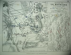
The Battle of La Rothiere, Antique Battle Map from Alison's History of Europe Atlas 1789 -1815
Verlag: William Blackwood & Sons, Edin. & London, 1875
Anbieter: Jacques Gander, Fairford, Vereinigtes Königreich
Verkäuferbewertung 5 von 5 Sternen
EUR 21,43
EUR 21,96 Versand
Versand von Vereinigtes Königreich nach USAAnzahl: 1 verfügbar
In den WarenkorbThis map shows The Battle of La Rothiere on 1st February 1814. Depicted are the positions of the Allies and the French; their cavalry, infantry and artillery; coloured mauve and blue, according to nationality. Positions are shown beflore and after the battle. The hand colouring is original , that is to say it dates to the publication of the atlas in 1875. The sheet measures 11 X 8.75 inches, the actual map from its borders measure approx. 6 X 8 inches. A section of the map shows the part of France explanatory of the 1814 campaign.The map is by W. & A.K. Johnston, Edin. and the scale is about 1 inch to the mile.The map is in very good condition, and very clean with perhaps the just the odd spot here or there.
-
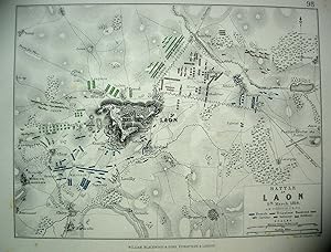
The Battle of Laon, Antique Battle Map from Alison's History of Europe Atlas 1789 -1815
Verlag: William Blackwood & Sons, Edin. & London, 1875
Anbieter: Jacques Gander, Fairford, Vereinigtes Königreich
Verkäuferbewertung 5 von 5 Sternen
EUR 21,43
EUR 21,96 Versand
Versand von Vereinigtes Königreich nach USAAnzahl: 1 verfügbar
In den WarenkorbThis map shows The Battle of Laon on 9th March 1814. Depicted are the positions of the French, Prussians and Russians; their cavalry, infantry and artillery; coloured blue mauve or green according to nationality. The hand colouring is original , that is to say it dates to the publication of the atlas in 1875. The sheet measures 11 X 8.75 inches, the actual map from its borders measure approx. 6 X 8 inches. The map is by W. & A.K. Johnston, Edin. and the scale is about 1. inch to the mile.The map is in very good condition, and very clean with perhaps the just the odd spot here or there.
-
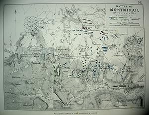
The Battle of Montmirail, Antique Battle Map from Alison's History of Europe Atlas 1789 -1815
Verlag: William Blackwood & Sons, Edin. & London, 1875
Anbieter: Jacques Gander, Fairford, Vereinigtes Königreich
Verkäuferbewertung 5 von 5 Sternen
EUR 21,43
EUR 21,96 Versand
Versand von Vereinigtes Königreich nach USAAnzahl: 1 verfügbar
In den WarenkorbThis map shows The Battle of Montmirail on 11th February 1814. Depicted are the positions of the French. Russians and Prussians; their cavalry, infantry and artillery; coloured blue, green or mauve according to nationality. The hand colouring is original , that is to say it dates to the publication of the atlas in 1875. The sheet measures 11 X 8.75 inches, the actual map from its borders measure approx. 6 X 8 inches. The map is by W. & A.K. Johnston, Edin. and the scale is about 1.25 inches to the mile.The map is in very good condition, and very clean with perhaps the just the odd spot here or there.
-
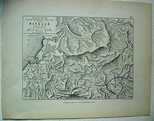
The Battle of Nivelle, Antique Battle Map from Alison's History of Europe Atlas 1789 -1815
Verlag: William Blackwood & Sons, Edin. & London, 1875
Anbieter: Jacques Gander, Fairford, Vereinigtes Königreich
Verkäuferbewertung 5 von 5 Sternen
EUR 21,43
EUR 21,96 Versand
Versand von Vereinigtes Königreich nach USAAnzahl: 1 verfügbar
In den WarenkorbThis map shows The Battle of Nivelle on 10th November 1813. Depicted are the positions of the Allies and French, their cavalry, infantry and artillery; coloured red or blue according to nationality. The hand colouring is original , that is to say it dates to the publication of the atlas in 1875. The sheet measures 11 X 8.75 inches, the actual map from its borders measure approx. 6 X 8 inches. The map is by W. & A.K. Johnston, Edin. and the scale is about 1.25 inches to the mile.The map is in very good condition, and very clean with perhaps the just the odd spot here or there.
-
The Battle of Abensberg, Antique Battle Map from Alison's History of Europe Atlas 1789 -1815
Verlag: William Blackwood & Sons, Edin. & London, 1875
Anbieter: Jacques Gander, Fairford, Vereinigtes Königreich
Verkäuferbewertung 5 von 5 Sternen
EUR 21,43
EUR 21,96 Versand
Versand von Vereinigtes Königreich nach USAAnzahl: 1 verfügbar
In den WarenkorbThis map shows The Battle of Abensberg on 20th April 1809. Depicted are the positions of the French & Bavarians and The Austrians; their cavalry, infantry and artillery; coloured blue and yellow, according to nationality. The hand colouring is original , that is to say it dates to the publication of the atlas in 1875. The sheet measures 11 X 8.75 inches, the actual map from its borders measures approx. 6 X 8 inches. The map is by W. & A.K. Johnston, Edin. and the scale is about 2.5 miles to the inche.The map is in very good condition, although the extreme left of the sheet is ragged where it was removed from its binding, this is well away from the actual map and would easily disappear when mounted. Otherwise the sheet is mostly quite clean with perhaps a few spots here and there.
-
The Battle of Arcole, Two Antique Battle Maps from Alison's History of Europe Atlas 1789 -1815
Verlag: William Blackwood & Sons, Edin. & London, 1875
Anbieter: Jacques Gander, Fairford, Vereinigtes Königreich
Verkäuferbewertung 5 von 5 Sternen
EUR 21,43
EUR 21,96 Versand
Versand von Vereinigtes Königreich nach USAAnzahl: 1 verfügbar
In den WarenkorbThese two maps show The Battle of Arcole on 15th, 16th, & 17th November 1796. one map shows the first day, 15th and the second map shows the third day, 17th November.Depicted are the positions of the French and Austrians; their cavalry, infantry and artillery; coloured blue and yellow, according to nationality. The hand colouring is original , that is to say it dates to the publication of the atlas in 1875. The sheets measures 11 X 8.75 inches, the actual map from its borders measures approx. 6 X 8 inches. The maps are by W. & A.K. Johnston, Edin. and the scale is about .8 inches to the mile.Both maps are in very good condition, and mostly quite clean with the just the odd spot here or there.
-
The Battle of Rivoli, Antique Battle Map from Alison's History of Europe Atlas 1789 -1815
Verlag: William Blackwood & Sons, Edin. & London, 1875
Anbieter: Jacques Gander, Fairford, Vereinigtes Königreich
Verkäuferbewertung 5 von 5 Sternen
EUR 21,43
EUR 21,96 Versand
Versand von Vereinigtes Königreich nach USAAnzahl: 1 verfügbar
In den WarenkorbThis map shows The Battle of Rivoli on 14th & 15th January 1797. Depicted are the positions of the French and Austrians; their cavalry, infantry and artillery; coloured blue and yellow, according to nationality. The hand colouring is original , that is to say it dates to the publication of the atlas in 1875. The sheet measures 11 X 8.75 inches, the actual map from its borders measures approx. 6 X 8 inches. The map is by W. & A.K. Johnston, Edin. and the scale is about 1.1 inches to the mile.The map is in very good condition, and is mostly quite clean with the just the odd spot here or there.
-
The Battle of Mount Thabor 1799, Antique Battle Map from Alison's History of Europe Atlas 1789 -1815
Verlag: William Blackwood & Sons, Edin. & London, 1875
Anbieter: Jacques Gander, Fairford, Vereinigtes Königreich
Verkäuferbewertung 5 von 5 Sternen
EUR 21,43
EUR 21,96 Versand
Versand von Vereinigtes Königreich nach USAAnzahl: 1 verfügbar
In den WarenkorbThis map shows The Battle Mount Thabor on 16th April 1799. Depicted are the positions of the French and Turks; their cavalry, infantry and artillery; coloured blue and green, according to nationality. The hand colouring is original , that is to say it dates to the publication of the atlas in 1875. The sheet measures 11 X 8.75 inches, the actual map from its borders measures approx. 6 X 8 inches. The map is by W. & A.K. Johnston, Edin. and the scale is about 4 miles to the inch.The map is in very good condition, and is mostly quite clean with the just the odd spot here or there.
-
The Battles of Turcoing & Tournay , Antique Battle Map from Alison's History of Europe Atlas 1789 -1815
Verlag: William Blackwood & Sons, Edin. & London, 1875
Anbieter: Jacques Gander, Fairford, Vereinigtes Königreich
Verkäuferbewertung 5 von 5 Sternen
EUR 21,43
EUR 21,96 Versand
Versand von Vereinigtes Königreich nach USAAnzahl: 1 verfügbar
In den WarenkorbThis map shows The Battles of Turcoing & Tournay on 18th May and 22nd may 1794. Depicted are the positions of the French and Allies; their cavalry, infantry and artillery; coloured blue and red , according to nationality. The positions before the battle are shown in light colouring.The hand colouring is original , that is to say it dates to the publication of the atlas in 1875. The sheet measures 11 X 8.75 inches, the actual map from its borders measures approx. 6 X 8 inches. The map is by W. & A.K. Johnston, Edin. and the scale is about .25 inches to the mile.The map is in very good condition, and is mostly quite clean with the just the odd spot here or there.
-
The Siege of Gerona, Antique Battle Map from Alison's History of Europe Atlas 1789 -1815
Verlag: William Blackwood & Sons, Edin. & London, 1875
Anbieter: Jacques Gander, Fairford, Vereinigtes Königreich
Verkäuferbewertung 5 von 5 Sternen
EUR 21,43
EUR 21,96 Versand
Versand von Vereinigtes Königreich nach USAAnzahl: 1 verfügbar
In den WarenkorbThis map shows The Siege of Gerona by the French Army of Catalonia from May to October 1809. Depicted are the positions of the French batteries; coloured blue. The hand colouring is original , that is to say it dates to the publication of the atlas in 1875. The sheet measures 11 X 8.75 inches, the actual map from its borders measures approx. 6 X 8 inches. The map is by W. & A.K. Johnston, Edin. and the scale is about 2.5 inches to the mile.The sheet has some surface tearing and a ragged edge on the extreme left of the sheet where it was removed from its binding, although it is well away from the actual map and will disappear easily once the map is mounted.
-
The Battles of Smolensko and Valtelina, Antique Battle Map from Alison's History of Europe Atlas 1789 -1815
Verlag: William Blackwood & Sons, Edin. & London, 1875
Anbieter: Jacques Gander, Fairford, Vereinigtes Königreich
Verkäuferbewertung 5 von 5 Sternen
EUR 21,43
EUR 21,96 Versand
Versand von Vereinigtes Königreich nach USAAnzahl: 1 verfügbar
In den WarenkorbThis map shows The Battles of Smolensko and Valtelina on 17th,18th & 19th August 1812. Depicted are the positions of the French and Russians; their cavalry, infantry and artillery; coloured blue and green, according to nationality. The hand colouring is original , that is to say it dates to the publication of the atlas in 1875. The sheet measures 11 X 8.75 inches, the actual map from its borders measures approx. 6 X 8 inches. The map is by W. & A.K. Johnston, Edin. and the scale is about 1.6 inches to the mile.The map is in very good condition, and is mostly quite clean with the just the odd spot here or there.
-
The Battle of Zurich 1799, Antique Battle Map from Alison's History of Europe Atlas 1789 -1815
Verlag: William Blackwood & Sons, Edin. & London, 1875
Anbieter: Jacques Gander, Fairford, Vereinigtes Königreich
Verkäuferbewertung 5 von 5 Sternen
EUR 21,43
EUR 21,96 Versand
Versand von Vereinigtes Königreich nach USAAnzahl: 1 verfügbar
In den WarenkorbThis map shows The Battle of Zurich on 4th June 1799. Depicted are the positions of the French and Austrians; their cavalry, infantry and artillery; coloured blue and yellow, according to nationality. The hand colouring is original , that is to say it dates to the publication of the atlas in 1875. The sheet measures 11 X 8.75 inches, the actual map from its borders measures approx. 6 X 8 inches. The map is by W. & A.K. Johnston, Edin. and the scale is about .8 inches to the mile.The map is in very good condition, and is mostly quite clean with the just the odd spot here or there.
-
The Battle of Stockach 1799, Antique Battle Map from Alison's History of Europe Atlas 1789 -1815
Verlag: William Blackwood & Sons, Edin. & London, 1875
Anbieter: Jacques Gander, Fairford, Vereinigtes Königreich
Verkäuferbewertung 5 von 5 Sternen
EUR 21,43
EUR 21,96 Versand
Versand von Vereinigtes Königreich nach USAAnzahl: 1 verfügbar
In den WarenkorbThis map shows The Battle of Stockach on 25th March 1799. Depicted are the positions of the French and Austrians; their cavalry, infantry and artillery; coloured blue and yellow, according to nationality. There is an inset map showing the Tyrol. The hand colouring is original , that is to say it dates to the publication of the atlas in 1875. The sheet measures 11 X 8.75 inches, the actual map from its borders measures approx. 6 X 8 inches. The map is by W. & A.K. Johnston, Edin. and the scale is about 2.5 miles to the inch.The map is in very good condition, and is mostly quite clean with the just the odd spot here or there.
-
The Battle of Jemappes, Antique Battle Map from Alison's History of Europe Atlas 1789 -1815
Verlag: William Blackwood & Sons, Edin. & London, 1875
Anbieter: Jacques Gander, Fairford, Vereinigtes Königreich
Verkäuferbewertung 5 von 5 Sternen
EUR 21,43
EUR 21,96 Versand
Versand von Vereinigtes Königreich nach USAAnzahl: 1 verfügbar
In den WarenkorbThis map shows The Battle of Jemappes on 6th November 1792. Depicted are the positions of the French and Austrians; their cavalry, infantry and artillery; coloured blue and yellow, according to nationality. the positions of the forces on the 5th are shown in lighter colouring. The hand colouring is original , that is to say it dates to the publication of the atlas in 1875. The sheet measures 11 X 8.75 inches, the actual map from its borders measures approx. 6 X 8 inches. The map is by W. & A.K. Johnston, Edin. and the scale is about 2.5 inches to the mile.The map is in very good condition, and is mostly quite clean with the just the odd spot here or there.
-
The Battles of Gross Beeren and Dennewitz, Antique Battle Map from Alison's History of Europe Atlas 1789 -1815
Verlag: William Blackwood & Sons, Edin. & London, 1875
Anbieter: Jacques Gander, Fairford, Vereinigtes Königreich
Verkäuferbewertung 5 von 5 Sternen
EUR 21,43
EUR 21,96 Versand
Versand von Vereinigtes Königreich nach USAAnzahl: 1 verfügbar
In den WarenkorbThis map shows The Battles of Gross Beeren on 23rd August 1813 and Dennewitz on 6th September 1813, half the sheet is devoted to each battle. Depicted are the positions of the French and the Allies; their cavalry, infantry and artillery; coloured blue and green, according to nationality. The hand colouring is original , that is to say it dates to the publication of the atlas in 1875. The sheet measures 11 X 8.75 inches, the actual map from its borders measures approx. 6 X 8 inches. The map is by W. & A.K. Johnston, Edin. and the scale is about .4 inches to the mile.The map is in very good condition, and is mostly quite clean with the just the odd spot here or there.