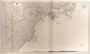
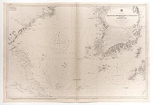
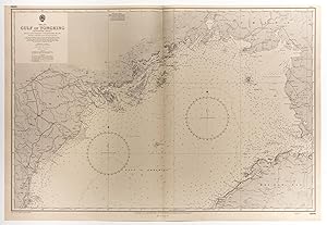
Admiralty chart (202 Ergebnisse)

Verlag: Taunton, 1979, 1979
Anbieter: Pennymead Books PBFA, Knaresborough, Vereinigtes KönigreichPennymead Books PBFA
Verkäufer/-in kontaktierenVerkäufer/-in mit 5 SternenVerbandsmitglied: PBFA
Zustand: Gebraucht
EUR 8,01
EUR 17,51 VersandVersand von Vereinigtes Königreich nach USAAnzahl: 1 verfügbar
Large chart 27 x 40" Two light folds.

Verlag: London, 1944, 1944
Anbieter: Pennymead Books PBFA, Knaresborough, Vereinigtes KönigreichPennymead Books PBFA
Verkäufer/-in kontaktierenVerkäufer/-in mit 5 SternenVerbandsmitglied: PBFA
Zustand: Gebraucht
EUR 16,01
EUR 17,51 VersandVersand von Vereinigtes Königreich nach USAAnzahl: 1 verfügbar
Detailed engraved chart. Light folds. 27 x 40".

Verlag: LondonPublished according to Act of Parliament at the Hydrographic Office of the Admiralty July 26th with revisions to 1920., 1841
- Karte
Anbieter: Robert Frew Ltd. ABA ILAB, London, Vereinigtes KönigreichRobert Frew Ltd. ABA ILAB
Verkäufer/-in kontaktierenVerkäufer/-in mit 5 SternenZustand: Gebraucht
EUR 30,05
EUR 11,67 VersandVersand von Vereinigtes Königreich nach USAAnzahl: 1 verfügbar
Original sea chart (68 x 50 cm) engraved by J. & C. Walker. Compass roses, inset maps, soundings marked in fathoms, some spots on the map marked in orange. Soiling, wrinkling, a few tears with some partial losses, notably to title cartouche. Surveyed by Captain W.F.W. Owen, 1826 and Capt. A.T.E. Vidal and Lieut. Bedford, 1836 an…d 1838. Rivre Gabon from French government surveys to 1892.

Verlag: Washington D.C.Published at the Hydrographic Office under the authority of the Secretary of the Navy Feb. with revisions to 1934., 1885
- Karte
Anbieter: Robert Frew Ltd. ABA ILAB, London, Vereinigtes KönigreichRobert Frew Ltd. ABA ILAB
Verkäufer/-in kontaktierenVerkäufer/-in mit 5 SternenZustand: Gebraucht
EUR 30,05
EUR 11,67 VersandVersand von Vereinigtes Königreich nach USAAnzahl: 1 verfügbar
Original engraved sea chart (80 x 93 cm). Soundings marked in fathoms, compass roses. Soiled and dampstained.

Verlag: Washington D.C.Published at the Hydrographic Office under the authority of the Secretary of the Navy with revisions to 1919., 1886
- Karte
Anbieter: Robert Frew Ltd. ABA ILAB, London, Vereinigtes KönigreichRobert Frew Ltd. ABA ILAB
Verkäufer/-in kontaktierenVerkäufer/-in mit 5 SternenZustand: Gebraucht
EUR 30,05
EUR 11,67 VersandVersand von Vereinigtes Königreich nach USAAnzahl: 1 verfügbar
Original engraved sea chart (80 x 93 cm). Soundings marked in fathoms, compass roses. Soiling and dampstaining.

Verlag: LondonPublished at the Admiralty.under the Superintendence of Rear Admiral Sir W.J.L. Wharton 25th October with revisions to 1920., 1914
- Karte
Anbieter: Robert Frew Ltd. ABA ILAB, London, Vereinigtes KönigreichRobert Frew Ltd. ABA ILAB
Verkäufer/-in kontaktierenVerkäufer/-in mit 5 SternenZustand: Gebraucht
EUR 30,05
EUR 11,67 VersandVersand von Vereinigtes Königreich nach USAAnzahl: 1 verfügbar
Original sea chart (51 x 68 cm) engraved by Edward Weller. Compass roses, soundings marked in fathoms, some spots on the map marked in orange. Generally a very good example. From the latest Italian Government Charts, 1911.

Verlag: LondonPublished at the Admiralty.under the Superintendence of Rear Admiral Sir W.J.L. Wharton December 17th with revisions to 1920., 1898
- Karte
Anbieter: Robert Frew Ltd. ABA ILAB, London, Vereinigtes KönigreichRobert Frew Ltd. ABA ILAB
Verkäufer/-in kontaktierenVerkäufer/-in mit 5 SternenZustand: Gebraucht
EUR 30,05
EUR 11,67 VersandVersand von Vereinigtes Königreich nach USAAnzahl: 1 verfügbar
Original sea chart (52 x 68.5 cm) engraved by Davies & Company. Compass rose, soundings marked in fathoms, some spots on the map marked in orange. Generally very good. From the latest Austrian Government Charts. Martin ica is a coastal village on the Croatian island of Cres, in Primorje-Gorski Kotar.

Sprache: Englisch
Verlag: THE ADMIRALTY, London, 1944
Anbieter: K Books Ltd ABA ILAB, York, YORKS, Vereinigtes KönigreichK Books Ltd ABA ILAB
Verkäufer/-in kontaktierenVerkäufer/-in mit 5 SternenZustand: Gebraucht - Gut
EUR 48,08
EUR 22,76 VersandVersand von Vereinigtes Königreich nach USAAnzahl: 1 verfügbar
No Binding. Zustand: Very Good. A very detailed original Admiralty chart, originally engraved in 1890 but with constant updating to 1944. Shows the mined area to the East of the Humber estuary entrance and the East Riding of Yorkshire, with the Caution "Fishing is prohibited in the Mined Area and passage through it is highly dan…gerous. Vessels disregarding this warning do so at their peril." Gives soundings in fathoms, direction and rate of tidal streams, other Cautionary Notes re buoys, lights and the constantly shifting changes in the Banks and Channels. Folded in sections. Some marking to the paper but clear and sound. Sheet No 1190.
Sprache: Englisch
Verlag: THE ADMIRALTY, London, 1944
Anbieter: K Books Ltd ABA ILAB, York, YORKS, Vereinigtes KönigreichK Books Ltd ABA ILAB
Verkäufer/-in kontaktierenVerkäufer/-in mit 5 SternenZustand: Gebraucht - Gut
EUR 48,08
EUR 22,76 VersandVersand von Vereinigtes Königreich nach USAAnzahl: 1 verfügbar
No Binding. Zustand: Very Good. A very detailed original Admiralty chart, originally engraved in 1942under the Superintendence of Vice-Admiral Sir John Edgell, but with constant updating to 1945. Shows areas in which it is forbidden to anchor or trawl - including one which has been amended in pen. Gives soundings in fathoms, dir…ection and rate of tidal streams, Cautionary Notes re traffic regulations in the Dover Straits plus additional Cautions re oyster beds, the entrance to thhe East Sholes, the changing shape of sand banks, location of South Falls etc. Includes the French coast between Calais and Boulogne. Shows outlines of the 3 lighthouses at South and North Foreland. Folded in sections. Some marking to the paper and damage to small section at edge of sheet with no loss to map. Sheet No 1895.
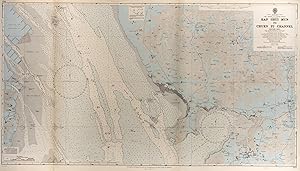
ADMIRALTY SURVEY CHART, FLAMBOROUGH HEAD TO HARTLEPOOL, 1944
ADMIRALTY SURVEY CHART, FLAMBOROUGH HEAD TO HARTLEPOOL, 1944
Sprache: Englisch
Verlag: THE ADMIRALTY, London, 1944
Anbieter: K Books Ltd ABA ILAB, York, YORKS, Vereinigtes KönigreichK Books Ltd ABA ILAB
Verkäufer/-in kontaktierenVerkäufer/-in mit 5 SternenZustand: Gebraucht - Gut
EUR 48,08
EUR 22,76 VersandVersand von Vereinigtes Königreich nach USAAnzahl: 1 verfügbar
No Binding. Zustand: Very Good. A very detailed original Admiralty chart, originally engraved in 1892 under the Superintendence of Captain W J L Wharton RN, but with constant updating to 1944. Shows the mined area offshore, with the Caution "Fishing is prohibited in the Mined Area and passage through it is highly dangerous. Vess…els disregarding this warning do so at their peril." Gives soundings in fathoms, direction and rate of tidal streams. Folded in sections. Some marking to the paper but clear and sound. Sheet No 1191.
ADMIRALTY SURVEY CHART, NORTH FORELAND TO ORFORDNESS INCLUDING THE ENTRANCE TO THE THAMES, 1945
ADMIRALTY SURVEY CHART, NORTH FORELAND TO ORFORDNESS INCLUDING THE ENTRANCE TO THE THAMES, 1945
Sprache: Englisch
Verlag: THE ADMIRALTY, London, 1945
Anbieter: K Books Ltd ABA ILAB, York, YORKS, Vereinigtes KönigreichK Books Ltd ABA ILAB
Verkäufer/-in kontaktierenVerkäufer/-in mit 5 SternenZustand: Gebraucht - Gut
EUR 48,08
EUR 22,76 VersandVersand von Vereinigtes Königreich nach USAAnzahl: 1 verfügbar
No Binding. Zustand: Very Good. A very detailed original Admiralty chart, originally engraved in 1933 but with constant updating to 1945. Shows the mined area to the East of the Thames entrance, with the Caution "Fishing is prohibited in the Mined Area and passage through it is highly dangerous. Vessels disregarding this warning… do so at their peril." Gives soundings in fathoms, direction and rate of tidal streams, other Cautionary Notes re buoys, lights and oyster beds. Folded in four. Some marking to the paper but clear and sound. Sheet No 1610.

Verlag: London, 1953, 1953
Anbieter: Pennymead Books PBFA, Knaresborough, Vereinigtes KönigreichPennymead Books PBFA
Verkäufer/-in kontaktierenVerkäufer/-in mit 5 SternenVerbandsmitglied: PBFA
Zustand: Gebraucht
EUR 32,02
EUR 17,51 VersandVersand von Vereinigtes Königreich nach USAAnzahl: 1 verfügbar
Large sea chart with a few neat m/s endorsements. 40 x 28" Impressive.

Verlag: LondonPublished at the Admiralty.under the Superintendence of Rear Admiral A. Mostyn Field 7th April ., 1908
- Karte
Anbieter: Robert Frew Ltd. ABA ILAB, London, Vereinigtes KönigreichRobert Frew Ltd. ABA ILAB
Verkäufer/-in kontaktierenVerkäufer/-in mit 5 SternenZustand: Gebraucht
EUR 60,11
EUR 11,67 VersandVersand von Vereinigtes Königreich nach USAAnzahl: 1 verfügbar
Original sea chart (68.5 x 51 cm) engraved by J. & C. Walker. Compass roses, inset plan, soundings marked in fathoms, some spots on the map marked in orange. A very good copy. From a French government survey, 1905.

Verlag: LondonPublished at the Admiralty.under the Superintendence of Captain A. Mostyn Field 4th March with revisions to 1921., 1905
- Karte
Anbieter: Robert Frew Ltd. ABA ILAB, London, Vereinigtes KönigreichRobert Frew Ltd. ABA ILAB
Verkäufer/-in kontaktierenVerkäufer/-in mit 5 SternenZustand: Gebraucht
EUR 60,11
EUR 11,67 VersandVersand von Vereinigtes Königreich nach USAAnzahl: 1 verfügbar
Original sea chart (68.5 x 51 cm) engraved by Davies & Company. Compass roses, soundings marked in fathoms, some spots on the map marked in orange. Some light wrinkling and browning mainly to margins. From the latest Russian government charts.

Verlag: Service Hydrographique de la Marine ., 1927
- Karte
Anbieter: Robert Frew Ltd. ABA ILAB, London, Vereinigtes KönigreichRobert Frew Ltd. ABA ILAB
Verkäufer/-in kontaktierenVerkäufer/-in mit 5 SternenZustand: Gebraucht
EUR 60,11
EUR 11,67 VersandVersand von Vereinigtes Königreich nach USAAnzahl: 1 verfügbar
Original engraved sea chart (75 x 104 cm). Soundings marked in fathoms, some spots on the map marked in red. Some toning and dampstaining, notably to upper right portion. D'àpres les levés exécutés successivement en 1920 et 192a par M.M. L. Pelissier et C. Villain.

Verlag: Madrid ., 1929
- Karte
Anbieter: Robert Frew Ltd. ABA ILAB, London, Vereinigtes KönigreichRobert Frew Ltd. ABA ILAB
Verkäufer/-in kontaktierenVerkäufer/-in mit 5 SternenZustand: Gebraucht
EUR 60,11
EUR 11,67 VersandVersand von Vereinigtes Königreich nach USAAnzahl: 1 verfügbar
Original engraved sea chart (72 x 110 cm). Soundings marked in fathoms, numerous inset plans, some spots on the map marked in yellow, blue, and pink. Toning, dampstaining, darkening to left hand portion. Levantada en los años de 1922 a 1925 por la Comision Hidrografica.

Verlag: Service Hydrographique de la Marine with revisions to 1927., 1915
- Karte
Anbieter: Robert Frew Ltd. ABA ILAB, London, Vereinigtes KönigreichRobert Frew Ltd. ABA ILAB
Verkäufer/-in kontaktierenVerkäufer/-in mit 5 SternenZustand: Gebraucht
EUR 60,11
EUR 11,67 VersandVersand von Vereinigtes Königreich nach USAAnzahl: 1 verfügbar
Original engraved sea chart (75 x 104 cm). Soundings marked in fathoms, inset map, some spots on the map marked in orange. Some light soiling mainly to margins and verso. D'àpres la reconnaissance effectuée en 1912 sous la direction de M.E. Fichot et al.

Verlag: LondonPublished at the Admiralty.under the Superintendence of Captain W.J.L. Wharton 25th June with revisions to 1914., 1894
- Karte
Anbieter: Robert Frew Ltd. ABA ILAB, London, Vereinigtes KönigreichRobert Frew Ltd. ABA ILAB
Verkäufer/-in kontaktierenVerkäufer/-in mit 5 SternenZustand: Gebraucht
EUR 60,11
EUR 11,67 VersandVersand von Vereinigtes Königreich nach USAAnzahl: 1 verfügbar
Original sea chart (69 x 102 cm) engraved by Edward Weller. Compass roses, soundings marked in fathoms, some spots on the map marked in orange. Generally a very good copy. Surveyed by Capt. E. Mouchez of the French Navy, 1867-70.

Verlag: LondonRe-published at the Admiralty.under the Superintendence of Rear Admiral Sir W.J.L. Wharton 23rd October with revisions to 1920., 1897
- Karte
Anbieter: Robert Frew Ltd. ABA ILAB, London, Vereinigtes KönigreichRobert Frew Ltd. ABA ILAB
Verkäufer/-in kontaktierenVerkäufer/-in mit 5 SternenZustand: Gebraucht
EUR 60,11
EUR 11,67 VersandVersand von Vereinigtes Königreich nach USAAnzahl: 1 verfügbar
Original sea chart (68.5 x 51 cm) engraved by Malby & Sons. Compass rose, vignette of the bay, soundings marked in fathoms, some spots on the map marked in orange. Some light marginal smudging, generally very good. From an Austrian Government survey 1870. With small corrections 1920. The Bay of Vlorë is a large bay of the Adriat…ic Sea situated along the Albanian Adriatic Sea Coast on the Mediterranean Sea in Southern Europe.

Verlag: LondonPublished at the Admiralty.under the Superintendence of Captain G.H. Richards 14th December with revisions to 1920., 1864
- Karte
Anbieter: Robert Frew Ltd. ABA ILAB, London, Vereinigtes KönigreichRobert Frew Ltd. ABA ILAB
Verkäufer/-in kontaktierenVerkäufer/-in mit 5 SternenZustand: Gebraucht
EUR 60,11
EUR 11,67 VersandVersand von Vereinigtes Königreich nach USAAnzahl: 1 verfügbar
Original sea chart (71 x 123 cm) engraved by Davies & Powell. Compass roses, inset maps, soundings marked in fathoms, some spots on the map marked in orange. Some light offsetting, generally very good. Surveyed by Lieut. G.R. Wilkinson et al., H.M.S. 'Medina' 1862.

Verlag: LondonPublished at the Admiralty.under the Superintendence of Rear Admiral W.J.L. Wharton 18th May with revisions to 1908., 1897
- Karte
Anbieter: Robert Frew Ltd. ABA ILAB, London, Vereinigtes KönigreichRobert Frew Ltd. ABA ILAB
Verkäufer/-in kontaktierenVerkäufer/-in mit 5 SternenZustand: Gebraucht
EUR 60,11
EUR 11,67 VersandVersand von Vereinigtes Königreich nach USAAnzahl: 1 verfügbar
Original sea chart (68 x 71 cm) engraved by Davies & Company. Compass rose, soundings marked in fathoms, some spots on the map marked in orange. Some light marginal soiling, generally very good. From a French government survey 1868.

Verlag: LondonPublished according to Act of Parliament at the Hydrographic Office of the Admiralty May 13th with revisions to 1915., 1846
- Karte
Anbieter: Robert Frew Ltd. ABA ILAB, London, Vereinigtes KönigreichRobert Frew Ltd. ABA ILAB
Verkäufer/-in kontaktierenVerkäufer/-in mit 5 SternenZustand: Gebraucht
EUR 60,11
EUR 11,67 VersandVersand von Vereinigtes Königreich nach USAAnzahl: 1 verfügbar
Original sea chart (51.5 x 69 cm). Compass roses, soundings marked in fathoms, some spots on the map marked in orange. Some slight marginal soiling, generally very good.
Verlag: LondonPublished at the Admiralty 19th Feb. . under the Superintendence of Rear Admiral E.G. Irving. O.B.E. Hydrographer 1962., 1962
- Karte
Anbieter: Robert Frew Ltd. ABA ILAB, London, Vereinigtes KönigreichRobert Frew Ltd. ABA ILAB
Verkäufer/-in kontaktierenVerkäufer/-in mit 5 SternenZustand: Gebraucht
EUR 60,11
EUR 11,67 VersandVersand von Vereinigtes Königreich nach USAAnzahl: 1 verfügbar
71 x 125cm. Colour printed sea chart with hand coloured additions. Stamp to verso noting corrections. Two vertical folds but generally very good.
Verlag: LondonPublished at the Admiralty 8th April under the Superintendence of Rear Admiral K.St.B.Collins C.B. O.B.E. D.S.C. Hydrographer. 1960., 1960
- Karte
Anbieter: Robert Frew Ltd. ABA ILAB, London, Vereinigtes KönigreichRobert Frew Ltd. ABA ILAB
Verkäufer/-in kontaktierenVerkäufer/-in mit 5 SternenZustand: Gebraucht
EUR 60,11
EUR 11,67 VersandVersand von Vereinigtes Königreich nach USAAnzahl: 1 verfügbar
71.5 x 121cm. Printed sea chart with hand coloured additions. Two stamps to verso from Lilley & Reynolds Ltd noting corrections to 1964. Two vertical folds but generally very good.
Verlag: LondonThe Admiralty., 1944
- Karte
Anbieter: Robert Frew Ltd. ABA ILAB, London, Vereinigtes KönigreichRobert Frew Ltd. ABA ILAB
Verkäufer/-in kontaktierenVerkäufer/-in mit 5 SternenZustand: Gebraucht
EUR 60,11
EUR 11,67 VersandVersand von Vereinigtes Königreich nach USAAnzahl: 1 verfügbar
66 x 99 cm. Quarter folded. Predominantly uncoloured, but with what would appear to be the lighthouses highlighted. Three printed labels bearing notes and cautions, two small sections of the chart pasted anew. Some old ink annotations and amendments. Some light soiling on verso, otherwise in good condition. Originally published…1936, this edition of the chart published 1944 and subsequently updated with manuscript ink annotations to 1948.
Verlag: LondonThe Admiralty. 9th March but with corrections up to 1945, 1888
- Karte
Anbieter: Robert Frew Ltd. ABA ILAB, London, Vereinigtes KönigreichRobert Frew Ltd. ABA ILAB
Verkäufer/-in kontaktierenVerkäufer/-in mit 5 SternenZustand: Gebraucht
EUR 60,11
EUR 11,67 VersandVersand von Vereinigtes Königreich nach USAAnzahl: 1 verfügbar
65 x 115 cm. Large sea chart of the waters between Melville Island and the North Coast of Australia. Predominantly uncoloured, but with a few points annotated in red. Folded. Pencil annotations on verso. Solied on verso, but generally in very good condition.
Verlag: LondonPublished at the Admiralty 18th Decr under the Superintendence of Vice-Admiral A.Day. C.B. C.B.E.D.S.O. Hydrographer. 1953. But with corrections to 1964., 1953
- Karte
Anbieter: Robert Frew Ltd. ABA ILAB, London, Vereinigtes KönigreichRobert Frew Ltd. ABA ILAB
Verkäufer/-in kontaktierenVerkäufer/-in mit 5 SternenZustand: Gebraucht
EUR 72,13
EUR 11,67 VersandVersand von Vereinigtes Königreich nach USAAnzahl: 1 verfügbar
71 x 107.5cm. Printed sea chart. Three stamps to verso from Lilley & Reynolds Ltd noting corrections to 1964. Two vertical folds but generally very good.

Verlag: LondonPublished at the Admiralty.under the Superintendence of Captain F.J. Evans 2nd September with revisions to 1920., 1878
- Karte
Anbieter: Robert Frew Ltd. ABA ILAB, London, Vereinigtes KönigreichRobert Frew Ltd. ABA ILAB
Verkäufer/-in kontaktierenVerkäufer/-in mit 5 SternenZustand: Gebraucht
EUR 84,15
EUR 11,67 VersandVersand von Vereinigtes Königreich nach USAAnzahl: 1 verfügbar
Original sea chart (51 x 69 cm) engraved by Davies & Company. Compass rose, soundings marked in fathoms, some spots on the map marked in orange. Some light marginal soiling, generally very good. From a French government survey of 1873.
Verlag: LondonPublishes at the Admiralty 20th Novr under the Superintendence of Captain A.Mostyn Field R.N. F.R.S Hydrographer. 1905 but with corrections to 1964., 1905
- Karte
Anbieter: Robert Frew Ltd. ABA ILAB, London, Vereinigtes KönigreichRobert Frew Ltd. ABA ILAB
Verkäufer/-in kontaktierenVerkäufer/-in mit 5 SternenZustand: Gebraucht
EUR 84,15
EUR 11,67 VersandVersand von Vereinigtes Königreich nach USAAnzahl: 1 verfügbar
71 x 104cm. Printed sea chart with hand coloured additions. One horizontal fold but generally very good.
Verlag: LondonPublished at the Admiralty 19th My under the Superintendence of Rear Admiral E.G. Irving. O.B.E. Hydrographer 1961. But with corrections to 1964., 1961
- Karte
Anbieter: Robert Frew Ltd. ABA ILAB, London, Vereinigtes KönigreichRobert Frew Ltd. ABA ILAB
Verkäufer/-in kontaktierenVerkäufer/-in mit 5 SternenZustand: Gebraucht
EUR 84,15
EUR 11,67 VersandVersand von Vereinigtes Königreich nach USAAnzahl: 1 verfügbar
70cm x 101cm. Printed sea chart with hand coloured additions. Stamp to verso noting corrections to 1964. Vertical fold but generally very good.


