Gesamtpreis (1 Artikel Artikel):
Versandziel:

accurate (28 Ergebnisse)
Direkt zu den wichtigsten Suchergebnissen
Suchfilter
Produktart
- Alle Product Types
- Bücher (19)
- Magazine & Zeitschriften (Keine weiteren Ergebnisse entsprechen dieser Verfeinerung)
- Comics (Keine weiteren Ergebnisse entsprechen dieser Verfeinerung)
- Noten (Keine weiteren Ergebnisse entsprechen dieser Verfeinerung)
- Kunst, Grafik & Poster (4)
- Fotografien (Keine weiteren Ergebnisse entsprechen dieser Verfeinerung)
- Karten (4)
- Manuskripte & Papierantiquitäten (1)
Zustand Mehr dazu
Einband
Weitere Eigenschaften
- Erstausgabe (2)
- Signiert (Keine weiteren Ergebnisse entsprechen dieser Verfeinerung)
- Schutzumschlag (Keine weiteren Ergebnisse entsprechen dieser Verfeinerung)
- Angebotsfoto (15)
Sprache (3)
Gratisversand
Land des Verkäufers
Verkäuferbewertung
-

SHE BELIEVED SHE COULD. BUT TACOS: "She Believed She Could So She Did" parody for people in the real world (lined blank journal / gag gift)
Anbieter: Revaluation Books, Exeter, Vereinigtes Königreich
Verkäuferbewertung 5 von 5 Sternen

EUR 9,44
EUR 11,58 Versand
Versand von Vereinigtes Königreich nach USAAnzahl: 1 verfügbar
In den WarenkorbPaperback. Zustand: Brand New. 100 pages. 9.00x6.00x0.23 inches. In Stock.
-

Accurate Smokeless Powders Loading Guide: Number One
Verlag: Accurate Arms Company Inc.
Anbieter: ThriftBooks-Dallas, Dallas, TX, USA
Verkäuferbewertung 5 von 5 Sternen
Paperback. Zustand: Good. No Jacket. Pages can have notes/highlighting. Spine may show signs of wear. ~ ThriftBooks: Read More, Spend Less.
-

Zen Mandala Coloring Book
Anbieter: Revaluation Books, Exeter, Vereinigtes Königreich
Verkäuferbewertung 5 von 5 Sternen
EUR 12,80
EUR 11,58 Versand
Versand von Vereinigtes Königreich nach USAAnzahl: 1 verfügbar
In den WarenkorbPaperback. Zustand: Brand New. 36 pages. 11.00x8.50x0.09 inches. In Stock.
-
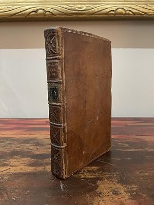
The Arabian Nights; Entertainments; consisting of One Thousand and One Stories, Volume II
Sprache: Englisch
Verlag: Printed for James Goodwin, 10 Ave-Maria- Lane, Paternoster Row, London, 1813
Anbieter: Ryde Bookshop Ltd, Isle of Wight, Vereinigtes Königreich
Verkäuferbewertung 5 von 5 Sternen
EUR 11,92
EUR 23,11 Versand
Versand von Vereinigtes Königreich nach USAAnzahl: 1 verfügbar
In den WarenkorbLeather Bound. Zustand: Fair. Firmly bound original full leather binding, gilt decorations and titles on the spine. Some rubbing to hinges, edges and extremities. Top edges rubbed, a little loss from the spine top, front board detached, pages mostly clean with some foxing present. Second volume of two volume set.
-
Accurate Smokeless Powder
Verlag: Accurate Arms Co., McEwen, 1994
Anbieter: Browse Awhile Books, Tipp City, OH, USA
Verkäuferbewertung 5 von 5 Sternen
Soft Cover. Zustand: Fine. 346pp. Size: Quarto.
-
Accurate Smokeless Powders Loading Guide: Number One
Anbieter: Aamstar Bookshop / Hooked On Books, Colorado Springs, CO, USA
Verbandsmitglied: RMABA
Verkäuferbewertung 4 von 5 Sternen

Soft cover. Zustand: As New. B guns, This large format softcover, 346 pages, is as NEW, red spine, gilt title.
-
Accurate Parts Mfg. Co. The Clutch - How to Service It. 1940
Verlag: Accurate Parts Mfg. Co., 1940
Anbieter: Riverby Books, Fredericksburg, VA, USA
Verkäuferbewertung 5 von 5 Sternen
Soft cover. Zustand: Good. Softcover. Brightly-colored red and yellow paper wraps, stapled at the fold, with white lettering on the front cover. Front cover depicts a sectional view of a clutch. Measures 8-1/2" x 11", 56 pages, in good condition. Illustrated throughout with black-and-white photographs, drawings and technical diagrams. Catalogue is intended to service the clutch that the company manufactures. It covers details of the construction of the clutch, methods of operation, frequent causes of malfunction, and methods for reconditioning your clutch. Illustrations throughout are commonly labeled, to show important components, or are otherwise closeup views of parts of the clutch. Covers are slightly rubbed. Edges and corners show wear and tear. Writing, in pen and pencil, is evident to front cover. The Accurate Parts Mfg. Co., a manufacturer of car parts, was based in Cleveland, Ohio. $25.
-
Accurate (R) Smokeless Powder; Reloaders Guide 2005
Verlag: Western Powders, Inc, Miles City, Montana, 2004
Anbieter: Ground Zero Books, Ltd., Silver Spring, MD, USA
Verkäuferbewertung 5 von 5 Sternen
Erstausgabe
Wraps. Zustand: Very good. Presumed First Edition, First printing. 63, [1] pages. Includes Accurate Powder Specifications, Introduction and Special Notes, Acknowledgments, Legend, Special Warnings, Accurate Smokeless Powder Descriptions, Smokeless Propellant Storage, Handgun Data, Cowboy Action Shooting, Rifle Data; Quick-Find Guide for Shotshell Data, Background Information on Shotshell Loading, Bushing Data (Volumetric Loading), Shotshell Data; Shotshell Information on Wads and Primers. What's New in the Load Guide: New Calibers: Handgun: 48 Ruger, 500 S&W; Revised Adjusted Data: Handgun: 7.62X25 Tokarev, 9mmx19P, .357 Magnum; .45 ACP; Rifle: .223 Remington, .270 Winchester, .45-70 Gov. This booklet is an introductory guide to the use of Accurate Smokeless Propellants, including the Scot series of shotshell propellants. The data for the metallic cartridges has been derived from the more comprehensive No. 2 loading guide. The shotshell data is the latest available on the Scot series, and is only available in this guide. Western Powders, Inc. has been one of North America's leading distributors of gun powder since 1972. Located in Miles City, Montana, our current operations evolved from our distribution of Dupont IMR Powders in the 1970s. Our business has grown significantly and we now distribute powder for every major brand of firearm propellants. After establishing a highly efficient distribution network for gun powders, we decided to develop and market our own brand of propellants in 1998 under the "Ramshot" name. To further broaden our operations, we purchased "Accurate Arms" in 2005 and "Montana X-Treme Gun Cleaning Products" in 2006. Our most recent brand introduction was Blackhorn 209 Muzzleloading Propellant, which has revolutionized the muzzleloading industry since its introduction in 2008. Every product developed by Western Powders sets the industry's highest standards for performance and reliability. Western Powders proudly supports the freedom to bear arms and strive to make hunting and recreational shooting more enjoyable for every one of our customers.
-
Loading Guide for Accurate Smokeless Powders, Fifth Edition; It's Time to Switch to Accurate!
Verlag: Accurate Arms Company, Inc, McEwen, TN, 1991
Anbieter: Ground Zero Books, Ltd., Silver Spring, MD, USA
Verkäuferbewertung 5 von 5 Sternen
Wraps. Zustand: Very good. Second printing [stated]. 32 pages. Oversized book, measuring 11 inches by 8-1/2 inches. Includes Introduction, Safety Notes, and information on Handguns and Rifles. Also includes Loading Data for Accurate 2700, which requires high loading density, as well as heavier bullet weights. Two items of ephemera have been laid in--one is a product flyer on Accurate Smokeless Powders, and one on Data for Accurate 2015br. The Accurate 2015br news release was addressed to John Lyman, The Tarheel Gunner who was a noted naval and arms authority. Smokeless powder is the name given to a number of propellants used in firearms and artillery that produce negligible smoke when fired, unlike the gunpowder or black powder they replaced. The term is unique to the United States and is generally not used in other English-speaking countries, which initially used proprietary names such as "Ballistite" and "Cordite" but gradually shifted to "propellant" as the generic term. The basis of the term smokeless is that the combustion products are mainly gaseous, compared to around 55% solid products (mostly potassium carbonate, potassium sulfate, and potassium sulfide) for black powder. Despite its name, smokeless powder is not completely free of smoke; while there may be little noticeable smoke from small-arms ammunition, smoke from artillery fire can be substantial. This article focuses on nitrocellulose formulations, but the term smokeless powder was also used to describe various picrate mixtures with nitrate, chlorate, or dichromate oxidizers during the late 19th century, before the advantages of nitrocellulose became evident. Since the 14th century gunpowder was not actually a physical "powder", and smokeless powder can be produced only as a pelletized or extruded granular material.[citation needed] Smokeless powder allowed the development of modern semi- and fully automatic firearms and lighter breeches and barrels for artillery. Burnt gunpowder leaves a thick, heavy fouling that is hygroscopic and causes rusting of the barrel. The fouling left by smokeless powder exhibits none of these properties (though some primer compounds can leave hygroscopic salts that have a similar effect; non-corrosive primer compounds were introduced in the 1920s. This makes an autoloading firearm with many moving parts feasible (which would otherwise jam or seize under heavy black powder fouling). Smokeless powders are classified as, typically, division 1.3 explosives under the UN Recommendations on the transportation of Dangerous goods - Model Regulations, regional regulations (such as ADR) and national regulations. However, they are used as solid propellants; in normal use, they undergo deflagration rather than detonation.
-
The Rose : A Treatise on the Cultivation, History, Family Characteristics,
Erscheinungsdatum: 1882
Anbieter: Ouromantiq Books, Brewster, NY, USA
Verkäuferbewertung 5 von 5 Sternen
Hardcover. Zustand: Good. 1882 copyright, no other date. Near VG. Minimal ex-library markings. Light external wear, a bumped corner, a bit of fraying at top of spine, gilt remains bright. Pages yellowed with occasional minor blemishes. Spine a bit slanted, bindign reasonably firm.
-
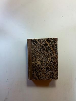
Opera Quoad Extant. Nova Editio Stereotypa. Tom II. Historiarum Libri V. Germania. Agricola. Dial. De Oratoribus. Index.
Sprache: Deutsch
Verlag: Caroli Tauchnitii, Lipsiae, 1846
Anbieter: ANTIQUARIAT Franke BRUDDENBOOKS, Lübeck, Deutschland
Verkäuferbewertung 5 von 5 Sternen
12° gebunden, HLn. Zustand: Gut. 397 S. Buch ist in altersgemäßem Zustand, Seiten altersbedingt nachgedunkelt, Einband etwas berieben/bestossen, Wir senden umgehend mit beiliegender MwSt.Rechnung. Sprache: Deutsch Gewicht in Gramm: 200.
-

Accurate Smokeless Powder Loading Guide Number One (1994)
Verlag: Accurate Arms Company, 1994
Anbieter: Elizabeth's Bookshops, Fremantle, WA, Australien
Verkäuferbewertung 4 von 5 Sternen
Softcover. Zustand: FINE! GUNS pp. 346 FINE COPY #301022 Elizabeth's Bookshops have been one of Australia's premier independent book dealers since 1973. Elizabeth's family-owned business operates four branches in Perth CBD, Fremantle (WA), and Newtown (NSW). All orders are dispatched within 24 hours from our Fremantle Warehouse. All items can be viewed at Elizabeth's Bookshop Warehouse, 23 Queen Victoria Street\, Fremantle WA. (Please note: Over standard weight or size. Orders via ABE Books or Biblio or from Overseas may incur additional postage charges. We will contact you prior to processing order to request your approval or contact us to confirm postage cost.).
-
The Essays of Michael, Seigneur de Montaigne, Translated into English. Volume III
Verlag: D. Chamberlaine, Dublin, 1760
Anbieter: John and Tabitha's Kerriosity Bookshop, Minneapolis, MN, USA
Verkäuferbewertung 5 von 5 Sternen
Zustand: Fine. 8th. Volume III of IV, in original binding in good condition with original cloth page holder still attached. Pages are clear and clean. Overall, a very good copy.
-
[John Joy Bell, Scottish journalist and chronicler of Glaswegian working-class life.] Autograph Letter Signed to 'Mr Keary' [Peter Keary, editor of Pearson's Weekly], explaining why the piece he is submitting for the '1000th Number' is sub-par.
Verlag: 22 June ; on letterhead of Clyde Cottage Craigendoran Helensburgh, 1909
Anbieter: Richard M. Ford Ltd, London, Vereinigtes Königreich
Verkäuferbewertung 5 von 5 Sternen
Manuskript / Papierantiquität
EUR 66,78
EUR 5,21 Versand
Versand von Vereinigtes Königreich nach USAAnzahl: 1 verfügbar
In den Warenkorb1p, 12mo. In good condition, lightly aged and worn. Folded for postage. Reads: 'Dear Mr Keary, / Enclosed is for 1000th Number of Pearson's Weekly. It is not what I wanted to do for you, but illness and other interruptions have spoiled my work for the last two months. So please reject if necessary. / Faithfully yours / J. J. Bell'.
-

Voyage au Cap de Bonne-Espérance et autour du Monde, avec le Capitaine Cook, et principalement dans le Pays des Hottentots et des Caffres Traduit par M.Le Tourneur.
Verlag: Paris, Buisson, 1787
Anbieter: Hünersdorff Rare Books ABA ILAB, London, Vereinigtes Königreich
Verkäuferbewertung 2 von 5 Sternen

EUR 715,48
EUR 26,05 Versand
Versand von Vereinigtes Königreich nach USAAnzahl: 1 verfügbar
In den WarenkorbHardcover. Zustand: Very Good. No Jacket. 3 volumes in 8vo. xxxvi + 389 + [1]p; [2] + 366p + [1]f errata; [4] + 366p+ [3]f. With one double-page engraved plate, one folding engraved map, and 12 folding engraved plates. Contemporary polished calf, spine gilt, hinges cracked but firm, corners worn. First French language edition of the author's eye-witness account of Captain Cook's second voyage to the Cape of Good Hope as part of his circumnavigation in 1772-5. Sparrman (1748-1820),professor of zoology at Uppsala University and an outstanding pupil of Linnaeus, accompanied the voyage as assistant to the naturalists Johann and Georg Forster which is related in the first volume. Most of the work comprises his observations on the flora, fauna and mixed population of the Cape Colony made during expeditions into the interior of the country when working as a doctor in Cape Town. The description of termites and their nests is especially noteworthy. First published in Swedish in 1783, and immediately translated into the major European languages, the book became a bestseller. It is thought to be the most accurate contemporary description of the Cape. The illustrations of the present French edition are considered the best. Du Rietz, Bibl. Polynesiana 1223; Mendelsohn II, p361.i.
-

Dänemark / Schleswig-Holstein / Südschweden.
Anbieter: Antiquariat Martin Barbian & Grund GbR, Saarbruecken, Deutschland
Verkäuferbewertung 5 von 5 Sternen
Kunst / Grafik / Poster
Kupferstich von Gibson nach Roberts, um 1750, 20x29,5 cm (am oberen Rand außerhalb der Darstellung etwas fleckig).
-

Vevey-Sion Blatt XVII
Erscheinungsdatum: 1875
Anbieter: Geographicus Rare Antique Maps, Brooklyn, NY, USA
Verbandsmitglied: ABAA ESA ILAB
Verkäuferbewertung 4 von 5 Sternen
Karte
Very good condition. Dissected and mounted on linen as issued. Some mended separations in linen not affecting surface of map. Size 21.5 x 29 Inches. This superbly detailed 1844 Dufour map of the municipalities of Brig-Glis and Airolo in the Lepontine Alps of Switzerland, from the first geometrically accurate map of the Swiss Confederation; this example is an 1875 revision of the map. It spans from the canton of Vaud to the canton of Valais. The eastern portion of Lac Léman is shown; much of the map shows the Rotten river valley, or the upper Rhone, showing the cities of Sierre, Sion, and Ridde. The Dufour Map This Brig-Airolo map is sheet 18 of Guillaume Henri Dufour's monumental, twenty-five sheet topographical map of Switzerland. The Dufour map was the first geometrically accurate depiction of the recently formed Swiss confederation . Work was initiated on the 1:100000 topographic map of Switzerland in 1832; the twenty-five sheets - each covering an area of 70 by 48 kilometers - were published serially between 1845 and 1865. An Organizational Feat Dufour oversaw the work of numerous scientists, topographers and engravers in order to achieve this masterpiece. Between 1834 and 1837 geodesist Johannes Eschmann compiled existing cantonal networks to form a 'Triangulation primordiale,' the first modern nationwide triangulation spanning Switzerland from the north to the south; these provided the geodetic reference system which formed the framework for the Dufour Map. Simultaneously, Dufour enlisted a team of surveyors to supply topographic data. In order to organize the efforts of so many - from survey to engraving - Dufour founded the Federal Topographical Bureau in Geneva in 1838. An Astonishing Degree of Precision The surveys were executed at a very high resolution, ranging from 1:50000 in alpine areas to 1:25000 in the Central Plateau, Jura and Southern Ticino areas; these were integrated into Eschmann's framework before surveys could even begin. While Dufour specified that his surveyors should do so 'as accurately as possible' it should be noted that there existed at the time no quantifiable standard for such accuracy to which to refer. In spite of this, analysis of the Dufour maps reveal a mean deviation of only 153 metres - a mere 1.5 millimeters on the map! A Pinnacle of the Engravers' Art After the original surveys were examined, they were then reached to the scale of 1:100,000 for uniformity, then transferred to copperplate, engraved, and printed. The Dufour maps are justifiably held in regard for the quality of their engraving, particularly in the presentation of Switzerland's wildly varied terrain. The maps' beautiful shading resulted in their distinctive three-dimensional effect. During a period in which the mapmaker's art was increasingly moving to lithography, the execution of these maps in copperplate represents a triumph of the cartographic medium dominant from the 16th century on. The map's quality was hailed from its production: the 1875 journal XXXX, reporting the cartographic offerings of that year's Geographical Congress at Paris, set it above the pack: Switzerland, though one of the smallest countries in Europe, nevertheless holds a foremost rank in this exhibition. The large Federal map, produced under the direction of General Dufour, - of whose recent decease we are reminded by the crepe ceiling the Swiss coat-of-arms, - is certainly one of the finest specimens of cartography in a large scale to be seen here. A comparison of it with the Swiss atlas surveyed 1786-1802 by Weiss, a copy of which is exhibited, forcibly brings home to us the great strides which the art of cartography has made since then. Publication History and Census The first sheets of the Dufour map were published in 1845 with the project culminating in 1865; it can be presumed that the individual maps were published in multiple editions in the intervening period. Nevertheless, we see only six examples of this separate sheet in.
-
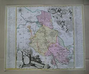
GEOGRAPHISCHE DELINEATION des Stiffts Ambts Wurtzen nebst den Aembtern Eilenburg und Düben mit denen darein gehörigen Städten Flecken und Dorffschafften auch angraentzenden Orthen
Verlag: um 1760., Amsterdam, 1760
Anbieter: Magdeburger Antiquariat, Magdeburg, ST, Deutschland
Verkäuferbewertung 5 von 5 Sternen
Altkolor. Kupferstich b. Petrus Schenk. ca. 47,5 x 55,5 cm. Dekorative Karte in schönem Altkolorit. Links unten mit ornamentaler Kartusche. Rückseitig handschriftlich betitelt und nummeriert.
-
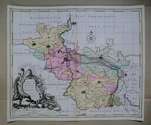
GEOMETRISCHER GENERAL RIS des Stiffts Merseburg
Verlag: Amsterdam, 1745
Anbieter: Magdeburger Antiquariat, Magdeburg, ST, Deutschland
Verkäuferbewertung 5 von 5 Sternen
Altkolor. Kupferstich b. Petrus Schenk. ca. 46 x 56 cm. Dekorative Karte in schönem Altkolorit. Links unten mit ornamentaler Kartusche.
-

Map of the Burman Dominions, and Adjacent Countries.
Erscheinungsdatum: 1829
Anbieter: Geographicus Rare Antique Maps, Brooklyn, NY, USA
Verbandsmitglied: ABAA ESA ILAB
Verkäuferbewertung 3 von 5 Sternen

Karte
Very good. Light wear and toning along original fold lines. Closed 6.5 inch tear alongthe right border professionally repaired on verso. Verso repairs to fold separations. Close right margin. Blank on verso. Size 30.5 x 24.5 Inches. This is an 1829 John Crawfurd and John Walker map of Burma (Myanmar). The map, considered the first accurate map of this region, was prepared to illustrate John Crawfurd's Embassy to Ava to negotiate with Burmese King Bagyidaw following the First Anglo-Burmese War (1824 - 1826). A Closer Look Centered on the Irrawaddy Valley, the map depicts from Calcutta to Yunnan Province in China and northern Laos and from Tassisudon to the mouths of the Irrawaddy River and the Gulf of Martaban. Dozens of villages, towns, and cities are labeled all along the Irrawaddy River from Rangoon to Mandalay, in the Irrawaddy Delta, and on the roads from Rungpoor to Bhamo and from Bhamo to Amarapura, but otherwise much is left blank, illustrating how little this region was known to European powers of the early 19th century. First Anglo-Burmese War Bagyidaw, aka Sagaing Min, the seventh king of the Konbaung Dynasty of Burma (1784 - 1846), inherited an empire near its height in terms of both territory and military power. He was unfortunate enough to share a border with British India, which had an interest in expanding its holdings into Burma. The British fostered rebellions in Bagyidaw's border provinces, including Arakan, Manipur, and Assam, all of which had been brought into the fold of Burmese dominion by Bagyidaw's grandfather. When Bagyidaw ordered his troops to peruse rebels into British territory, the war began. With an ill-defined border and rugged mountainous jungle territory, the First Anglo-Burmese War turned out to be one of the longest, most expensive, and bloodiest wars in the history of British India. Nonetheless, it ended decisively for the British, despite throwing British India into a severe economic crisis and ultimately contributing to the demise of the British East India Company's remaining privileges Crawfurd Mission to Ava, 1826 In the aftermath of war, Lord Amherst sent John Crawfurd on an envoy mission to Burma to negotiate terms with the chastised King Bagyidaw. Crawfurd and his party traveled up the Irrawaddy from Rangoon to Ava on the paddle steamer Diana with four support boats. Arriving at the Court of Ava, Crawfurd negotiated a complete surrender of Assam, Manipur, Cachar, Jaintia, Arakan Province, and Tenasserim to British India. The king also conceded to a trade agreement in return for a delay in indemnity payments and later sent his own mission to Calcutta. For the Burmese Empire, it was the beginning of the end. The Third Burmese Empire, for a brief time the terror of British India, was crippled and no longer a threat to the eastern frontier. The Konbaung Dynasty itself went through a sharp decline until, ultimately, all of Burma was under British control. Scientific and Reconnaissance Tour de Force The Crawfurd expedition was forced to delay its return to India so that the shallow-draft riverboats cold be repaired. They used the time to gather intelligence on the region, contributing to this map, as well as collect seven chests of fossils from the riverbank near Magwe, and nearly 18,000 botanical specimens for the Calcutta Botanical Garden. The work led to the discovery of a new species of mastodon, the Stegolophodon. It also provided the first accurate data regarding the interior of Burma, laying the groundwork for further British dominance in the region. Publication History This map was published in 1829 to accompany Journal of an Embassy from the Governor General of India to the Court of Ava by John Crawfurd. It was engraved by John Walker and published in London. It does not appear in all editions of Crawfurd's narrative and there appears to be only one edition.
-
Map of the Kingdoms of Siam and Cochin China.
Erscheinungsdatum: 1828
Anbieter: Geographicus Rare Antique Maps, Brooklyn, NY, USA
Verbandsmitglied: ABAA ESA ILAB
Verkäuferbewertung 4 von 5 Sternen
Karte Erstausgabe
Good. Some wear along old fold lines. Repaired and reinforced split along bottom horizontal fold. Some discoloration and repair where originally tabbed into volume, at center. Laid down on archival tissue. Size 37 x 25 Inches. This rare large-format 1828 map of Southeast Asia, compiled by John Walker to illustrate John Crawfurd's mission to Siam (Thailand), is the first accurate survey of the coasts of Siam. Coverage extends from China to Singapore and from the Gulf of Martaban (Burma) to Vietnam and Hainan. Siam at the time was inaccessible to European merchants and even diplomats, with its coasts and interior largely unknown. This map is an amalgam of European sources, but with regard to Siam, it was derived primarily from secretly acquired early 19th-century Siamese surveys previously unknown to Europeans and, for all intents and purposes, still lost. Historical Context Following the resurgence of the Kingdom of Siam after the Burmese-Siamese War (1765 - 1767), Siam emerged as a major political power and the central state in Southeast Asia. The regional destabilization following Siamese victory led to a power vacuum in Burma, which precipitated a series of further conflicts, both between Siam and Burma and between Burma and Great Britain, lasting well into the early 19th century. The British took advantage of the weak Burmese military to seize additional territory in Assam, Manipur, and Arakan during the First Anglo-Burmese War (1824 - 1826). At the same time, Siam continued to grind away at both Burmese territory to the west and parts of Laos and Cambodia to the east, stopped only by Vietnamese and French forces in Indochina. To the south, Britain exerted a strong influence over the Malay States, leaving only Siam as a fully independent and powerful Southeast Asian state resistant to European influence. The Crawfurd Mission The Scottish linguist, diplomat, doctor, and colonial administrator John Crawfurd (1783 - 1868) was sent to the Kingdom of Siam by the Governor-General of India, Lord Francis Edward Rawdon-Hastings (1754 - 1826). Hastings was interested in evaluating the growing power of Siam, acquiring a reliable reconnaissance of Siamese lands, establishing trade relations, and understanding Siamese policy with regard to both the Malay States to the south (particularly Penang, to which the British had laid claim) and to French attempts to establish a colonial presence in Vietnam. While the mission failed to establish trade relations, evaluate Siamese political positions regarding Penang, or explore the interior, Crawfurd did collect cartographic materials detailing the coast, much of which John Walker compiled into this map. The 'Mohammedan Mariner' In the appendix to Crawfurd's Journal of an Embassy from the Governor-General of India to the Courts of Siam and Cochin-China , he lists the sources of this remarkable map. Many are new surveys conducted en route , earlier British surveys of the Malay States and Bengal, and French sources for Indochina, but the bulk of the map as it relates to Siam is based upon cartography passed clandestinely to Crawfurd by a Siamese Muslim navigator. To quote Crawfurd, From the Cape of Patani to the point of Kwiis taken from a Mohammedan mariner, a native of Siam, possessed of considerable intelligence-who was acquainted with the use of maps and the quarterstaff, and could even take an altitude of the sun with our quadrants. he goes on to describe how this same mariner, in fear of his life, divulged less and less information the closer the came to Siam, .a great deal of useful information . as we approached Siam they became much more shy and reserved, and now communicated nothing without a strict injunction to secrecy. They constantly resisted our solicitations to assist in translating the Governor-general's letter into Siamese, observing that the communication of his Majesty's titles would be considered as the divulgement of a state secret, which might cost them their lives. The comman.
-
Carte Marine de la Mer Caspiene.
Erscheinungsdatum: 1721
Anbieter: Geographicus Rare Antique Maps, Brooklyn, NY, USA
Verbandsmitglied: ABAA ESA ILAB
Verkäuferbewertung 3 von 5 Sternen
Karte
Very good. Platemark visible. Light offsetting. Stated size represents two panels. Size 37 x 24.5 Inches. A seminal production, this is Guillaume Delisle's 1721 map of the Caspian Sea according to the surveys of Van Verden and S. I Soimonov. It is the first printed map of the Caspian Sea based upon actual survey work. Although other cartographers also copied the work of Van Verden and Soimonov, Delisle was the first, and his mapping is the finest and truest to the original manuscript. The First Accurate European Map of the Caspian Sea Around 1718 Russian Tzar Peter the Great sponsored a number of cartographic expeditions to the farthest reaches of his vast empire. One such was a command to map the Caspian Sea given to Dutch navigator Carl Van Verden. Though well-known since antiquity, the world's largest lake was largely ignored by surveyors until Van Verden's work in the early 18th century. By charging Van Verden with the mapping of the Caspian, Peter the Great hoped to lay the foundations for further expansion into Central Asia, Persia, and eventually India. Van Verden created the most advanced mapping of the Caspian Sea to date, offering a new perspective on the region and opening the navigational possibility of the world's largest lake. Delisle Presents New Information to the World In 1721 Peter presented the Paris Académie Royale des Sciences with a copy of S. I. Soimonov and Carl Van Verden's map of the Caspian region. Without further delay, Delisle redrew the map (with great care), translated the inscriptions into French and printed it on separate sheets in reduced size in the Travaux of the Academy. He also included the map in his Atlas. In this way, the exact outline of the Caspian Sea, drawn on the Russian map of 1720, first appeared in a map prepared in western Europe. In 1723, G. Delisle returned anew to the map of Verden and Soimonov and transposed from it the correct outline of 'Caspia' to the map which he was preparing. This can be seen by the outline of Verden and Soimonov on their map of 1720. This point is confirmed by the caption on the map of 1723 which describes it as 'dressée pour l'usage du Roi (Louis XIV) sur la carte de cette mer faite par l'ordre du Czar (Peter I)'. The fact that Delisle used a map with Russian names becomes clear from the inscriptions on the map of 1723. 'Dua Brata ou Les Deux Freres','Ostrov Giloi-Isle Habite', 'Ostrov Svinoi ou Isle des Cochons', 'Krasnie Vodi ou Les Eaux Rouges', and others. The map proper is surrounded by eight inset maps detail various gulfs, bays, ports, and rivers. The upper sheet has two large cartouches, the left bearing the title and dedication to Van Verden and the right a description of the map. The right-hand cartouche also features two dragons. Publication History and Census This map was originally prepared for publication in the Académie Royale des Sciences journal Bibliographie Générale des Travaux Historiques , but it was also simultaneously issued independently and in various Delisle atlases. It is well represented in institutional collections. References: Rumsey 4764.082, 4764.081, 4764.083. Allen, W. E. D., 'The sources for G. Delisle's 'Carte de Pays Voisin de la Mer Caspienne of 1723', Imago Mundi, Vol. 13 (1956), pp. 137 - 150.
-

Italien / Italia / Italie.
Anbieter: Antiquariat Martin Barbian & Grund GbR, Saarbruecken, Deutschland
Verkäuferbewertung 5 von 5 Sternen
Kunst / Grafik / Poster
Kupferstich von G. Rollos, 1771, 19x28,5 cm.
-
Verlag: Albion Publishing Co. London. January Vol.1 no.1. Large folio, 1894
Anbieter: Patrick Pollak Rare Books ABA ILAB, SOUTH BRENT, DEVON, Vereinigtes Königreich
Verkäuferbewertung 4 von 5 Sternen
EUR 77,51
EUR 28,94 Versand
Versand von Vereinigtes Königreich nach USAAnzahl: 1 verfügbar
In den Warenkorbpp. 16. Illustrated. On pink paper. Disbound, a few small marginal tears, else in very good condition. *The Mirror of Life is in the field as an organ to interest the sportsman, theatrical man, and all who appreciate first-class illustrations and bright reading matter. Boxing will be given precedence over all other sport, and every encouragement possible shown to advance its popularity.' Considerable prominence is given to the forthcoming fight between Jim Sullivan and Charles Mitchell, in Florida. COPAC no copy.
-
BIBLE
Anbieter: Librairie Philosophique J. Vrin, Paris, Frankreich
Verkäuferbewertung 4 von 5 Sternen
BIBLENovum Jesu-Christi Testamentum, ad Exemplar Vaticanum accurate revisum.P., Barbou, 1785, in-12 rel. pl. veau, dos lisse, orné, filets dorés sur les plats, roulettes dorées sur les coupes et sur les chasses, tranches dorées, front. gravé. 400 gr.
-

Karte von Luxemburg und dem nordwestlichen Saarland.
Anbieter: Antiquariat Martin Barbian & Grund GbR, Saarbruecken, Deutschland
Verkäuferbewertung 5 von 5 Sternen
Kunst / Grafik / Poster
Altkolorierter Kupferstich von Ioh. Bapt. Homann, Nürnberg, um 1730, 48x58 cm (Van der Vekene: 3.07 B) *Die Karte zeigt das Gebiet zwischen Namur, Münstereifel, Saarlouis und Stenay.
-
Karte der Meerenge von Gibraltar, links davon ein Vogelchauplan von Cadiz und Umgebung sowie von Ceuta, rechs davon eine Detaillan von Gibraltar und 1 Karte von Minorca, darunter Ansichten von Cadiz, der Festung Gibraltar sowie Tanger von
Anbieter: Antiquariat Martin Barbian & Grund GbR, Saarbruecken, Deutschland
Verkäuferbewertung 5 von 5 Sternen
Kunst / Grafik / Poster
der See- und Landseite. Flächenkolorierter Kupferstich von Johann Baptist Homann, Nürnberg, um 1730, 48,5x57,5 cm (rückseitig teils Papierreste einer alten Rahmung).
-
Vogelschauplan von Metz und Umgebung.
Sprache: Deutsch
Anbieter: Antiquariat Martin Barbian & Grund GbR, Saarbruecken, Deutschland
Verkäuferbewertung 5 von 5 Sternen
altkolorierter Kupferstich bei Homann-Erben, 1738, 47x55 cm *Prachtvoller, dekorativer Plan der Stadt. *Es liegen zwei Kolorit-Varianten vor. Bitte wählen Sie bei einer eventuellen Bestellung die gewünschte Variante.